Snowbirding 2022: Campsite Log

Some details about the places I camped during my winter 2021/22 trip to points south.

I thought I’d keep track of the places I camped each night in case anyone wants to try any of them.

Edited February 17, 2022:
Where I am now/just added: Navaro Beach Camp, , CA.

PlaceCostHookupsFacilitiesConnectComments
Three Islands State Park, ID$36*E **G **C*Rate includes non-ID surcharge. **Water turned off for season.
Pahranagat National Wildlife Refuge, NVfreenoneT G *C*Multiple pit toilets. Lakeside sites. Wildlife, hiking/biking trails. Close to road.
Valley of Fire State Park, NV. Atyl Campground.$35*E W **T S G****Rate includes non-NV surcharge. **Dump station only. ***WiFi available for a fee. Nice sites, quiet, red rocks. Good value.
Lake Mead National Recreation Area, NV. Stewart’s Point.freenoneT*C*Pit toilets in one area. Huge area right on the lake. Many campers but lots of space. Quiet, private.
Lake Mead National Recreation Area, AZ. Willow Beach Campground.$57*E W S **T S L G RW ****Rate includes Good Sam discount and tax. **Sewer on site and at dump station. ***Free WiFi for one device. Overpriced but very pleasant. 50% off 65+ with pass.
Lake Mead National Recreation Area, AZ. Kingman WashfreenoneT *C*One central pit toilet. Quiet, underutilized, early sunset because of canyon, 3 miles down gravel road. You can camp right on the lake. Coyotes, burros.
Lake Mead National Recreation Area, NV. Six Mile Covefree *noneT G *C ****Park entrance fee or pass is required. **Central pit toilets. ***Weak come-and-go cell signal. Quiet (on weekdays), 30 minute drive down gravel road from park entrance station. You can camp right on the lake. Beware of soft sand in parking area.
Davis Camp. Bullhead City, AZ$36.25*E W **T S GC*Includes extra fee for dogs and tax. **Dump station. County park campground on Colorado River just downstream from Davis Dam.
Oatman-Topock Dispersed BLM CampingfreenonenoneC**Usable Cell phone signal on Verizon. Close to road, rugged terrain.
Needle Mt Road BLM Dispersed CampingfreenonenoneC**Usable Cell phone signal on Verizon. Relatively close to freeway, rugged terrain.
Lake Havasu State Park, Overflow Camping Area$25.00*T S GC*Dump station available. Limited number of beachfront sites. Inadequate generator rules.
Pomosa Road Dispersed Camping, Quartzsite, AZfreenonenoneC**Usable Cell phone signal on Verizon. Very quiet.
Holtville Hot Spring BML Long Term Camping area$40.00*noneT S** GC*$40 covers up to 14 consecutive days in this and other long term areas. **Toilet and shower are at the hot spring. No soap allowed. Relatively flat, featureless area with dispersed camping. Lots of long term campers with expansive solar setups.
New Camp, Salton Sea Recreation Area$37 *E W **T S*** G RC*Rate includes $7 reservation fee. **Dump station only. ***Shower was solar hot water, $1/token. Hookup campsites were either in a large parking area or adjacent to main road with railroad track nearby. Camp store closed. I would not camp there again; not worth the money.
Joshua Tree South BLM Dispersed CampingfreenonenoneCLarge area along maintained gravel roads just south of Joshua Tree National Monument. Many campers, but plenty of space. Easy access to I-10 freeway about 1 mile away. Remarkably quiet.
Rice Ranch, Quartzsite AZ$40*E W SGC***Somewhat discounted rate due to past business relationship. **Strong signal but slow due to heavy load on local cell towers during Quartzsite’s busy period. Centrally located very near two main venues, bicycling distance to all others. At noisy intersection.
A Friend’s House, Gilbert, AZ$0n/an/an/aEvery year I visit with some friends in Gilbert, AZ. I stay in their guest room and let my camper sit empty in their driveway. The last night of my stay, they had more houseguests so I moved into the camper for the night, still parked in their driveway and not hooked up to utilities.
USFS Apache Jct Dispersed Camping$0nonenoneC**Cell signal was acceptable but not good. Wide open area not far from off-road vehicle recreation parking. Shooting within 1/2 mile before dark and before dawn in the morning. Coyotes. Two late arrivals slept in their vehicles and departed before light, which was kind of weird. Beautiful desert.
Catalina State Park, Tucson (Ringtail area dry camping)$20none*T S G RC***Dump station available. **Cell signal was acceptable but not good. Nice park with many hiking, biking, and equestrian trails. Dog friendly. Main campgrounds offer electric and water at sites; nearly impossible to reserve.
Casino Del Sol RV Park, Tucson, AZ$56E W ST S L GC W**Wifi near central building only. New campground with asphalt parking surrounded by gravel. Newly planted trees. No ambiance at all, but plenty of amenities. Expensive.
Las Cienegas National Conservation Area$0nonenone*C*Pit toilets available in group camping areas. Active historic cattle ranch(es) with dispersed camping.
A friend’s house, Sierra Vista, AZn/an/an/an/aMy Gilbert friends have a new second home in Sierra Vista and invited me to check it out. We stayed two nights and I helped them with a few of their renovation chores. It was wicked cold those two nights and I was glad to be indoors.
BLM Darby Wells Road Dispersed Camping, Ajo, AZ$0nonenoneCDispersed camping in Sonoran desert just south of an open pit copper mine.
Holtville Hot Spring BML Long Term Camping area$40.00*noneT S** GCSee notes from first stay. I stayed for another 6 nights in February.
Mojave Narrows County Park, Victorville, CA$39E W ST S GCCounty campground right next to TWO train tracks. Sites were dirty, land was poorly kept. Other campers were loud, but train was worse; it ran all night. NOT recommended.
Gaviota Lane, Ventura, CA$0nonenonenoneRelatively quiet side street behind a strip mall with an apartment complex across the street.
Jalama County Beach Campground, Lompac, CA$50none*T S G RW***I picked one of the beachfront sites which had no hookups. Other sites had hookups. There was a dump station. **No cell signal at all; WiFi was iffy. Very nice campground 14 miles down a twisty road.
Limekiln State Park, Lucia, CA$35noneT S G RnoneTiny campground tucked into a canyon under a bridge. Some sites are near the beach; others are in a dense wooded area next to a creek. No cell signal. Quiet. Pleasant stay but being out closer to the beach would have been nicer.
Bay Flat Road, Bodega Bay, CA$0nonenoneCRecommended to me by campground host at full Bodega Dunes Campground. Pullout alongside the road right on the bay. Quiet except for fog horn, barking sea lions, and some traffic.
Navaro Beach Campground$35noneT* GC***Pit toilets. **Very weak cell signal on Verizon was enough to check in at social media and send/receive texts. Pleasant campground adjacent to a beach. Just 10 sites include table and fire ring. Very quiet.

Key to codes

HookupsFacilitiesConnectivity
E – Electric
W – Water
S – Sewer
T – Toilet
S – Shower
L – Laundry
G – Garbage
R – Recycle
C – Usable Cell Signal (Verizon)
W – Free WiFi

Snowbirding 2022: Glenns Ferry ID to Alamo NV

This second trip vlog post should be a bit of an improvement. What do you think?

Well, I took the feedback I got from folks who watched my first Snowbirding 2021 vlog post and I used it to make some improvements — as I could.

The Time-lapse

The main problem was the time-lapse out the truck’s front window. A lot of folks just thought I was just throwing tons of photos out there in rapid fire. I guess that’s what a time-lapse is.

At least one person suggested slowing it down; I actually did slow it down to 50% of normal speed. Slower would make the video even longer and most folks simply don’t have 10+ minute attention spans. So I used the same speed in this video.

Another person suggested recording video of the whole drive and using clips. That would probably be better except for two problems:

  • I’d have a heck of a time choosing the clips.
  • Recording 8 hours of 4K video would take up a ton of storage space.

But I do like this idea and I think I’ll try to put it to work the next time I move to a new spot. But not in the next video; I’ve already recorded that with the same time-lapse settings. Sorry!

Why include it at all? I really think the terrain change is fascinating and hope some viewers do, too. And remember — you can always stop the picture to take a better look at one of the clips.

Music

Some folks said that the silent time-lapse wasn’t quite right. That it needed music. I’ve got you covered. I happened to have two royalty-free music clips on my laptop when I compiled the video on Monday evening. (That was a good thing because I had absolutely no Internet connection on any of my devices at Monday’s campsite.) One of the clips worked well (in my opinion) and I added it with ducking (a reduction of sound level) when I was narrating.

Talking Head Narration

I’m still fine-tuning this. I realized that the best way to do it was to narrate a segment with the selfie camera when I was near the end of the drive segment. I also realized that I needed to keep it short and simple.

The narration during time-lapse in this video was actually two separate clips. It took four tries to get the first clip. (Hell, I was just driving down the road so I did multiple takes. No distraction; I just push a button, talk, and push the button again.)

The second clip was done in two takes but it was pretty bad and needed a lot cut out. You can see the cuts. You can also sense how tired I am at the end of it. I’d had a frustrating stop in Wells where the credit card reader at the pump wouldn’t work, the cashier wouldn’t let me just fill the tank (I had to give her a dollar amount), the DEF I bought cost a whopping $22 for 2 gallons, and I couldn’t get the DEF bottle open in the 21°F temperature outside. The unedited narration includes me whining about all of this and I cut most of it out. But I sure do look defeated at the end of that clip.

I recorded the final narration when I edited the video, which was two nights later.

The Video

Here’s the video; it was posted after the date of this blog post, which matches the day of arrival at my Pahranagut National Wildlife Refuge campsite (Saturday, December 11, 2021).

The Next Video

There’s no driving in the next video. It’ll cover some of what I did during the time I spent at the wildlife refuge with my pups.

In the meantime, your feedback is still welcome. I’m trying hard to get a format that pleases viewers while meeting my needs without sacrificing my sanity.

Snowbirding 2022: Malaga WA to Glenns Ferry ID

My first day of travel — in vlog format.

Well, I’m off on this year’s snowbirding trip to points south. I came very close to not going. It was last week’s cold weather snap and the fact that my house-sitters had no where to live if I didn’t leave that finally got me packed and out the door.

I’m trying something new this year: video logging or vlogging of my travels. This video is my first stab at the format. It’s not perfect but as I edit and compile the video, I get more ideas on how to make it better so I expect my entries to improve as time goes on.

Why am I doing this? Well, I want to be able to vlog my future boat journeys. Let’s face it: most people these days would rather watch a video than read a blog — even if they both contain the same content. And I really do get a kick out of showing off some of the stuff I see and do along the way. So these videos are my way of learning how to and practicing vlogging.

I’m using three cameras to make these videos, but I’ll likely streamline it down to just two. A GoPro Hero 8 produces time-lapse videos of my drive. I think folks might get a kick out of seeing some of the terrain I drive through. There’s a whole lot of nothing out west and the folks who live in big cities often have no clue. (Yes, I did pass a “Next Gas 111 Miles” sign yesterday; if the camera caught it, I’ll share it.) It’s also interesting to see how the geology changes. And the weather.

The other two cameras are actually iPhones. One is the iPhone 8 Plus I got for free about 3 years ago when I bought my iPhone XS. It’s not connected to a cell plan but it still works great as a camera and on an Internet connection for creating and sharing content. I had it set up mounted to make selfies while I drove. I later realized that I didn’t like the way I had to do a freeze frame of the video to insert my commentary so I’m likely to discontinue it. The other is my new iPhone 13 Pro, which I use for handheld selfie videos while out of the truck. I’ll likely set this up to record occasional selfies behind the wheel. Two cameras is enough. It’s not like I’m flying a helicopter or anything. ;-)

I compile the video content on my MacBook Air — the same one I was “forced” to buy back in August or September while I was cruising on the Great Lakes. It’s a better machine than the 2yo MacBook Pro I’d been using so I got that machine all clean up and sent it back to Apple for a $380 gift card and set this one up as my main laptop. I use an app called Screenflow, which seems to work fine and gives me picture-in-picture capabilities. It also does a great job optimizing the rendered files so they’re remarkably small, even at 4K resolutions.

The main hurdle I’ve got is to get the video uploaded. My laptop uses my iPhone or iPad as a hotspot and Verizon has managed to degrade hotspot upload/download speeds to the point where it’s nearly impossible to share video. So I fooled it today by using AirDrop to send the finished file from my laptop to my iPhone and then upload it to YouTube from there. (It’s still taking quite a while, though, so maybe Verizon fooled me into thinking that would work?) I may have to upload these in batches in the future, possibly when taking up table space at a Starbucks or other WiFi hotspot with decent bandwidth. But since I don’t expect to see those more than once a week or so, don’t you expect to see these posts much more often than that.

That said, here’s the video:

I also want to say again that I’m just a few (11 as of this morning) YouTube Channel subscribers short of being able to do livestream videos from a mobile device. If you’re not a subscriber, why not?

Snowbirding 2022: Planning My Winter Travels

I start planning for a few months on the road.

I travel south every winter and have been doing so since moving to Washington in 2013. I camp out in an RV — at first, my giant fifth wheel and later one of two different slide in truck campers. I still have that second truck camper and will be taking it south again this year.

Let the Past Guide My Future

Last winter, I spent 2 1/2 months camped out on BLM land along the Colorado River. I had a great campsite, a good friend for company about half of that time, and a comfortable, productive stay. But I’d also brought along a shit-ton of extra equipment — a 12-foot cargo trailer full of it. It made my campsite very comfortable, but it also made it very inconvenient to travel.

My friend Bill reminded me — in an offhand way — of a simple fact: I’d sold my ultra comfortable fifth wheel and bought a truck camper because I wanted the convenience of being able to go anywhere I wanted to go. By hooking up a trailer to it, I was losing the benefit of the truck camper’s small footprint, mobility, and (for lack of a better word) parkability. Why was I doing that?

The answer is, I don’t know.

I guess that if I wanted to go to a campsite and stay there for 2 1/2 months, it doesn’t really matter how big my rig is. That old fifth wheel would have been the ultimate in luxury parked near the river last year. (As a matter of fact, I did park it there for a few weeks a few years ago on my last trip south with it.) But what if I actually wanted to travel around and see stuff? Take a few tips from Bill’s travel routine?

And that is what I want. If all goes well over the next year or so, this will be my last year driving down to Arizona and California with a camper on my truck. I should make it count.

The Lure of Staying Home

My biggest problem this year is that I don’t really want to leave home.

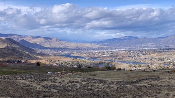
I love my home. It’s comfortable and it has everything I want or need to stay busy and make the most of my time. And even though there’s a 6-week period where the sun does not actually shine on my property — it certainly shines out on the Wenatchee Valley, which I can see clearly from every window in my home.

Autumn View
If this isn’t something worth seeing out the window every day, I don’t know what is.

And no, I don’t really mind the cold or snow. I don’t particularly like it, but I don’t hate it.

What I do hate is the short winter days. The sun is currently setting here at around 4:20 PM and it’s dark by 5 PM. Since I don’t have a regular job, my body clock is my only real clock. And since I’m going to bed when it’s still light out in the summer when the sun sets at 9 PM, it’s hard to stay up for 5 hours after it gets dark in the winter. I feel ready for bed by 7 PM — and if I happen to fall asleep around then, I’m usually up by 2 AM. And that really sucks.

So it’s mostly the darkness that makes me want to leave town. There’s 90 minutes more of daylight in Arizona and the clocks seem to be more practically set; the sun is currently setting at 5:20 PM down in Phoenix. That extra hour really makes a difference to me.

And I won’t deny that warm weather is a plus. Last year, I wore a t-shirt outside from the day I arrived at my campsite on the Colorado River south of I-10 just before Thanksgiving until the day I left Death Valley in mid February. Yeah, it got chilly at night, but all day long, I was able to soak up the sun. I really do love the sun.

So at this point, as I sit in my camper at the Spokane Fairgrounds and Expo Center on a Sunday morning, waiting for the last day of an Arts and Crafts show to begin, I’m working hard to convince myself that I really do need to start my trip south right after Thanksgiving.

The Plan

The plan is that I have no plan. And that’s causing a problem, too.

Because I’m not going to go to a familiar spot and park for two months or more, part of that time with a friend, I really don’t know what I’m going to do. So I need to make a plan.

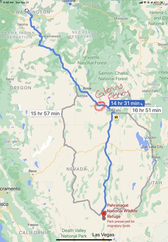
The beginning of the plan is pretty easy. I’ll take the fastest route south: I-84 southeast through Washington, Oregon, and Idaho to Twin Falls and then US-93 south to I-15 just outside of Las Vegas.

If I get an early enough start and the weather is good, I’ll spend the first night at Glenns Ferry in Idaho, where there’s a state park campground not far off I-84 where I can plug in. (I like to plug in in cold weather so I can run my quiet portable electric heater to save propane and battery power.) The next day, I’ll continue into Twin Falls and down US-93 into Nevada. I’ll have “arrived” in the south when I reach one of my favorite enroute camping destinations: Pahranagat National Wildlife Refuge just south of Alamo. If it is as I remember it — totally under utilized, quiet, and free — we’ll spend two nights there and enjoy some hiking around the lakes.

Route South
My route south with stopping points. This is the same route I took annually when I came north for cherry season back when I lived in Arizona, so I know it very well.

The “we” includes my pups, Lily and Rosie, of course.

From there, I’m thinking of Valley of Fire State Park southeast of there. I doubt we’ll get a campsite in the park, but we’ll definitely do some hiking on the trails there. Again, my rig parks just like any other truck, so parking spaces aren’t an issue. We’ll likely camp on some BLM land east of there, which I’d camped at long ago with my big rig. This time, however, we might spend a few days and go exploring close to the shoreline of Lake Mead. There appears to be a ghost town down there and I can never resist a good ghost town hike.

From there — well, I have a loose plan.

I spent some time yesterday morning with Google Maps, trying to figure out where to go. I’d considered heading east through a few of the National Parks in southern Utah, but I suspect the elevations will make them cold. My camper is not a good winter rig; it has terrible insulation. I could imagine myself blasting the propane heater all night every night and waking to near dead batteries and tanks I’d have to fill every few days. I doubted commercial campgrounds would be open for a power connection. And then there were daytime activities — am I really going to want to hike or explore, possibly in snow, if the temperature is hovering around freezing? I’m not fooling myself: the answer is no.

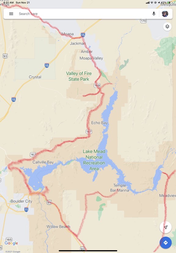
So I thought I’d continue southwest along Lakeshore Road and over the Colorado River into Arizona, keeping just far enough from Las Vegas to avoid traffic. There are campsites along Lake Mead — both on the park’s paved roads and on unpaved roads that my 4WD truck shouldn’t have any trouble negotiating. I thought I’d try a few of those, depending on the weather. I expect it to be relatively warm during the day and cool (or maybe even cold) at night. The goal is to find campsites where I can relax, get out and hike, and not be bothered by other campers and their equipment. I considered a visit to Willow Beach campground with a boat rental and a trip back up to the Arizona hot springs, but I’m not sure if I want the expense. That campground is a great place to refresh my rig after dry camping for a while, but it’s crazy expensive and the boat rental isn’t cheap either. (As I near my early retirement, I’m starting to budget myself. Or at least try to.)

Lake Mead Area Explorations
Here’s a map of the Lake Mead area, marked up with the places I’m thinking of exploring. There are several places where I can access the lake where dry camping should be easy.

From there, south to I-40 at Kingman, perhaps with a quick stop at Kingman mine to replenish my supply of turquoise beads. I was thinking of driving along Route 66 eastbound — I’ve never done the long Arizona stretch. It would be great to find a campsite somewhere out there.

Then on to Flagstaff, where I’d likely have to park at a commercial campground, if any are open, just to keep my rig warm at night. I’d like to go back to Lowell Observatory and walk around town a bit. Flag is at 7000 feet and cold in the winter, so how long I stay depends on what the weather is like.

I did think of visiting the Grand Canyon along the way, but that’s really weather dependent. If there’s snow on the ground, I won’t. If not and if it’s been dry, I might go up there and spend a night in the National Forest just south of the park. I’ve always wanted to do that but I know that the roads can get pretty muddy. And then there’s the cold.

After Flag — well, I don’t know.

I wanted to go into New Mexico — it’s been ages since I was there — and hoped to visit Albuquerque and Santa Fe and maybe even Taos. But a quick look at elevation numbers pushed that thought right out of my mind. Santa Fe is at 7000 feet or more and in December, that means cold. (See above.)

Camping Map
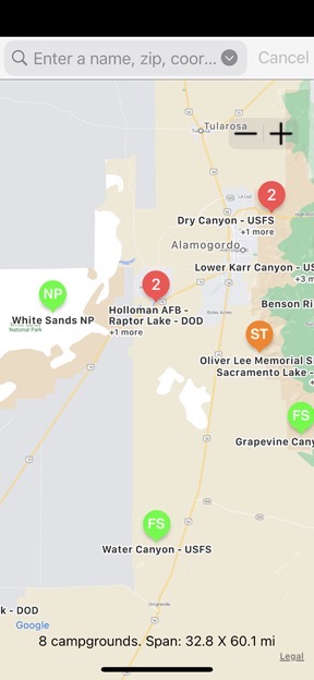
Here’s a zoomed out screen grab from the Ultimate CG app on my iPhone for the area near White Sands. This app, like many others with the same functionality for iOS and Android devices, taps into a database of public campgrounds and campsites, many of which are free. It’s perfect for campers who want to stay as far from KOAs as possible.

So the solution is to stick to lower elevations or destinations farther south. I might start around Albuquerque and travel south from there. I’ve always wanted to visit White Sands. And there seems to be some good remote camping options down there.

Once I’m down there, I can continue west back into Arizona. I need to be in Tucson at the beginning of February for a jewelry-making class, but I seriously doubt my travels up to that point will take me through December and January. While my friend Bill has no qualms about zig-zagging back and forth through the southwest when he travels, my rig doesn’t get 25 mpg. In fact, I’m lucky to get half that, which means I burn twice as much fuel. At $3 to $4 per gallon for diesel, it starts adding up. (Remember, I’m trying to get into a budget mindset.)

So maybe I should go south from Flagstaff and stick to places in Arizona? Maybe camping near Sedona’s red rocks? Heading back to the Arizona side of the Colorado River? Now I’m heading into the territory I wanted to avoid: the same place I spent last year. While I wouldn’t mind spending a few days in Quartzsite in mid January — I want to attend the Pow Wow again — I don’t want to camp long term anywhere near Quartzsite. The Pow Wow is January 19 through 23. I prefer to go during the week (instead of on the weekend) to minimize exposure to crowds. So that pretty much sets when I need to be in Quartzsite.

And then there’s Tucson from February 2 through 5.

So I have to plan around that. What do I do between the two? Head over to southern New Mexico? Visit my friends in Gilbert and Chandler? Or Wickenburg? Or check out that campsite Bill showed me last winter in California, south of Desert Center? Or go farther west, perhaps all the way out to San Diego?

And will I be able to meet up on the road with my friend Bill? Possibly for a trip up to our favorite hot springs resort near Death Valley?

And then there’s the possibility that I might need to be home by February 10 to prep for crew duties on another boat trip — this time on the Intracoastal Waterway traveling at a slower pace from Charleston, SC to as far as we get in 2 1/2 months. (I’ll know more in a few days about whether that will actually happen; I’ve got my fingers crossed.)

I have to mention here that the possible boat trip is yet another reason why I’m not so motivated to head south. As I mentioned at the top of this post, I love my home. It’s comfortable. It’s easy to live in. If I go south for 2 1/2 months and then go on a boat trip for 2 1/2 months, that’s 5 months away from home. Do I really want to be away that long? I know I definitely want to do another boat trip, but do I really want to do another trip to Arizona?

So as you can see, I don’t really have a plan. I have ideas for a plan. Too many ideas.

The Clock is Ticking

Meanwhile, the clock continues to tick and calendar pages continue to whiz by. My house sitters expect to move in on December 1, which is less than two weeks from today. I can put them off until Christmas — they have somewhere else to stay until then — but do I really want to head south then?

I don’t know. I’m just making this up as I go along.

Snowbirding 2020 Postcards: A Foggy Drive

Can’t enjoy the scenery when you can’t see it.

Although it was an outstandingly beautiful morning in Twin Falls, ID, 15 minutes south on US 93 put me in thick fog. Visibility, at times, dropped to far less than 1/4 mile as the road rose and then fell through the fog layers.

Fog
There wasn’t much to see because of the thick fog and I had to keep focused on what was in front of me anyway. Photo includes a meat and cheese snack on the dashboard, which I bought in Starbucks to eat along the way.

Miraculously, I was able to stick to the speed limit — 70 mph — for most of my drive. The road is painfully straight in most places and there was very little other traffic.

The fog came and went pretty much all day long, finally lifting as I descended on the final stretch of US 93 before it intersects with I-15. By that time, I’d driven through rain and snow and had been stuck behind a semi with broken brake lights (and apparently broken cruise control) for about 100 miles. I was a very happy camper when I finally got around him.