One more video. I think this is one of the best I’ve done since arriving in Washington State. Unfortunately, the SD card filled up about 30 seconds before I landed.
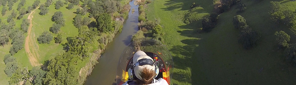
In this video, I’m flying low up the Columbia River from Lake Chelan Airport to Pateros. The air is calm and the water surface is almost as smooth as glass.
I’ve been very busy lately — too busy to write a real entry. But here’s another helicopter video for those who are interested in these things.
In this video, I’m coming in to Lake Chelan Airport from the south. The video includes a 1500 fpm descent — that’s about the same descent rate as an engine-failure autorotation maneuver — to the Columbia River. Includes some views of Chelan Falls and the lake.
I relocated to Pateros, WA today. I’d been based in Quincy, WA for about three weeks when my contracts ended. My second batch of contracts had been pushed back a week, leaving me with 2 weeks with nothing to do. But I soon found another contract — this one 50 miles (as the helicopter flies) north at Brewster. Because the motel at Brewster was supposed to be pretty bad, they set me up at the Lake Pateros Motor Inn, right on the Columbia River, between Brewster and Lake Chelan.
I flew up to Chelan to meet with my dispatcher. He’s the guy who will call me and send me to the various orchards that need drying. I used my POV.1 camera to capture the highlights (such as they were) of my flight from Quincy Airport to Chelan Airport. You can view it here:
After filling up with fuel and killing time reading about the 100 Things to Do in Chelan, my contact, Dan, drove up. After a quick chat, he told me I should move my helicopter over to an area away from the pumps. That, of course, required that I start up the helicopter and fly it over. It was about 200 yards away, in a grassy area on the other side of a bunch of hangars. I suspect that Dan just wanted to check out my hovering abilities because there really wasn’t any reason for me to move. But I moved and made a nice smooth landing on the grass.
I got into his truck and he went over the paperwork with me. There was a lot of it, but not more than I can handle. Then he drew a map to show me where the motel in Pateros was and where I should land the helicopter beside it. We talked about where the orchards were. He said he’d send Mark, another pilot, out to fly with me this afternoon to show me the orchards. And that was it.
Well, he did tell me a funny story about what his one-year-old puppy did one afternoon when he left her home alone, but I’d better not repeat it here. Let’s just say it involved dirty laundry, a doggie pool, and the UPS lady.
I climbed back into my helicopter as Dan drove away. I fired it up and turned on the camera. I then proceeded to record the video embedded below. This video features a landing on the grassy spot to the east of the hotel, right along the river.
I have to say that I’m getting better at recording these things. Although I don’t like the mount I used for these flights — I call it the “wiggle-stick” because of the way it vibrates in flight — I am getting better at narrating what’s going on. I hope some of the people who visit the blog find them interesting. If you do, please use the Comment link or form to let me know so I keep delivering them.
Fighting stir-craziness by taking the helicopter out for a spin.
I must have brought Arizona weather — the clear cloudless skies but not the heat — with me to central Washington. Since Thursday, the weather here has been pretty much perfect. Saturday was the fourth beautiful day in a row. It was also the sixth day since the last time I’d flown. And while I could have spent another day in my camper or under its awning, reading or writing, with time off for a walk or a bike ride, I was ready to do something more substantial.
It was time to go flying.
I put it off as long as I could. But by 12:30, I was on my way to the airport, where Zero-Mike-Lima is resting in a rented T-hangar. I put the pilot door back on, stowed my helmet in the big plastic storage box I keep in the hangar to keep dust off my things. Then I installed my POV.1 camera on the helicopter’s nose and hooked it into the audio system. The helicopter had already been pre-flighted on Tuesday when I thought I was going to fly for work, so I just hooked up the tow bar and dragged the helicopter out to the ramp.
I took my time about it. I wasn’t in any rush. Truth is, I still hadn’t decided on where I was going to go. In fact, even when I took off at about 1 PM, I didn’t know for sure where I was going.
I headed southwest, over the golf course and campground where I’m staying. Then I continued on toward the Gorge Amphitheater. There’s a resort/winery near there called Cave B and I wanted to identify it from the air. I’m also hoping to get some tour flights on nice days with some of their guests. (It’s nice to fly, but it’s nicer to fly when someone else is paying you to do it.) From there, I hopped on the Columbia River, making a hard right to follow it upriver toward Wenatchee.
The Columbia River is one of the great rivers of America. It starts somewhere up in Canada and winds southwest through valleys, canyons, and steep gorges, with numerous dams along the way. The dams aren’t in place to hold back water in an arid land. Instead, they’re in place to generate electricity. This gives the residents of Washington State cheap, reliable power. It also makes a little place like Quincy, WA attractive for companies like Microsoft and Intuit, both of which have built data centers among the crops.
In this area, where the river flows in a wide valley, there’s often orchards alongside. The first of these along my flight path was at Crescent Bar, where a cherry orchard stretches up the side of the hill. Crescent Bar is a recreational area, with campgrounds, condos, boat ramps, and a golf course. It was surprisingly quiet that day — a Saturday — and I could only assume that cold water or high gas prices kept boaters out of the water.
I continued upriver, snapping photos of the orchards I was responsible for drying that season. The photos didn’t come out very good; there was a lot of glare in the cockpit bubble. Most of these orchards are not far above water level. It’s warmer at these elevations than it is on higher terrain, closer to Quincy. I’d be drying the higher elevation orchards in the next part of the season. Maybe, if I was lucky, I’d be sent farther north when that was done, perhaps to dry cherries closer to the Canadian border in August.
I got a photo of the Rock Island Dam as I overflew it. I know it’s not the best photo, but it does give you an idea of the kinds of dams along this river. Most of them are short and wide, spanning the river and allowing the water to drop just a few feet. This is apparently enough to generate mass quantities of electricity. The drawback to all this is the power lines — they’re all over the place anywhere near a dam. This is a hazard for low-flying aircraft. Although I’ve cruised parts of the Colorado River at just a few hundred feet, I’d never do the same here. Too many damn wires!
Beyond the dam was the outskirts of Wenatchee. I took one photo while still downriver, hoping to capture the snow-capped mountains in the distance, but forgot to take any photos while closer. Instead, I let the POV.1 video camera do the job. Here’s a segment of video as I flew along the Columbia River through Wenatchee. East Wenatchee is on the right and Wenatchee is on the left.
(Keep in mind that the video camera is mounted on the outside of the helicopter, on its nose. I have no way to adjust it in flight, so sometimes I mention things that simply are not visible to the camera.)
I continued on up the river, passing over a number of dams and overflying more small communities on the banks of the river. I could have lived in any of those houses — at least in the summer months. I assume the area gets pretty darn cold in the winter.
I reached Chelan Falls about 40 minutes into the flight and followed them up to Lake Chelan. The falls were a beautiful turquoise blue color — probably a trick of the light on the rushing water. The video doesn’t do it justice. I overflew the town and flew partway up the northeast shore of the lake, then made a U-turn and returned back to the Columbia River. I’ll have to explore Chelan another time. (If the weather continues to keep me free from flying duties, I may drive up tomorrow!)
I continued up the Columbia with the vague idea of flying to the Coulee Dam. I was overflying another dam when I checked my chart and realized I still had quite a distance to go. I honestly can’t afford to spend too much unpaid time in the helicopter, so I cut the flight short, climbing up out of the valley to the southeast. At first, I thought I’d go back to Ephrata for fuel, but then decided to beeline it to Wenatchee. I wanted to check out the fuel facility there, since I’m likely to stop there for fuel when drying some of my orchards.
I landed and topped off my tanks at the self-serve pumps. It’s vital that I have full tanks of fuel when I start flying for cherry work, and I brought the level all the way up to the top of both tanks. Then I went inside to chat with the guys in the FBO. One, the guy at the desk, was a “nice young man” kind of kid — 18 years old, friendly, eager to help. He asked me questions about flying helicopters for a living. The other guy, the line guy, was a bit older and kind of crude and bossy. When I mentioned I was in the area to dry cherries, he cut me off before I could finish talking and told me to move my helicopter to the end of the ramp. I told him I wasn’t based in Wenatchee and I think he had a problem understanding that. I tried to limit my conversation to the desk guy, but the line guy kept butting in. After a while, I got tired of it and left.
I flew back along the Columbia River as far as Crescent Bar, then climbed up to Quincy. The video below records that 15-minute flight, beginning just after takeoff in Wenatchee.
It had been a great flight with near perfect weather. But I’m looking forward to doing the kind of flying that brought me here. You can bet I’ll report on that when I get a good taste of it.
A late afternoon takeoff from the helipad on the west end of Wickenburg Airport’s ramp. On board with me are three wranglers from the local guest ranch — each on their very first helicopter ride. But the shadow steals the show.
I don’t know why, but the audio didn’t come through on Viddler. I may try to upload it again. For now, you’ll have to be satisfied with the video only.
Update: After fiddling around with the original video and compressing it prior to re-upload, I got the sound to work right. Here’s the good version of the video, with sound.
 I put it off as long as I could. But by 12:30, I was on my way to the airport, where Zero-Mike-Lima is resting in a rented T-hangar. I put the pilot door back on, stowed my helmet in the big plastic storage box I keep in the hangar to keep dust off my things. Then I installed my POV.1 camera on the helicopter’s nose and hooked it into the audio system. The helicopter had already been pre-flighted on Tuesday when I thought I was going to fly for work, so I just hooked up the tow bar and dragged the helicopter out to the ramp.
 In this area, where the river flows in a wide valley, there’s often orchards alongside. The first of these along my flight path was at Crescent Bar, where a cherry orchard stretches up the side of the hill. Crescent Bar is a recreational area, with campgrounds, condos, boat ramps, and a golf course. It was surprisingly quiet that day — a Saturday — and I could only assume that cold water or high gas prices kept boaters out of the water.
 I got a photo of the Rock Island Dam as I overflew it. I know it’s not the best photo, but it does give you an idea of the kinds of dams along this river. Most of them are short and wide, spanning the river and allowing the water to drop just a few feet. This is apparently enough to generate mass quantities of electricity. The drawback to all this is the power lines — they’re all over the place anywhere near a dam. This is a hazard for low-flying aircraft. Although I’ve cruised parts of the Colorado River at just a few hundred feet, I’d never do the same here. Too many damn wires!
 Beyond the dam was the outskirts of Wenatchee. I took one photo while still downriver, hoping to capture the snow-capped mountains in the distance, but forgot to take any photos while closer. Instead, I let the POV.1 video camera do the job. Here’s a segment of video as I flew along the Columbia River through Wenatchee. East Wenatchee is on the right and Wenatchee is on the left.
 I flew back along the Columbia River as far as Crescent Bar, then climbed up to Quincy. The video below records that 15-minute flight, beginning just after takeoff in Wenatchee.