Drifting through Napa Sacramento Valley by balloon.
As I mentioned in a recent blog post about Thursday’s helicopter flight through Napa Valley, I’d been invited to take a spot on a hot air balloon flight with Napa Valley Balloons, Inc. on Friday morning out of Yountville (just north of Napa). I actually did the flight on Friday as planned. Well, sort of.
I was invited to fly by Bob, the pilot I’d met a few weeks before at the airport where I’m currently living in the Sacramento area. Bob had landed with his passengers in what I consider my “backyard” here — the ramp I can see from the back window of my RV. I’d taken some photos of his landing and had sent the best one to him. He said he’d try to get me on a future flight; I told him I’d take him and two friends up in my helicopter. After too many windy days, the weather had finally calmed down and I was scheduled for the first flight with an opening: Friday, March 21.
I got my confirmation with instructions via email. All passengers were supposed to meet at Domaine Chandon in Yountville at 6:30 AM. Google Maps told me that was about an hour away. And because I don’t like to be late to anything, I gave it an extra half hour of drive time. That meant leaving at 5 AM.
I’m an early riser and didn’t have any trouble making that departure time. With my first cup of coffee in a travel mug, I put Penny and her breakfast into the truck and we headed out.
I’d just passed the exit for Winters when my cell phone rang. It was Bob. “Don’t leave yet,” he told me. “I think there’s fog in the valley. We might depart from Winters instead.”
“I just passed Winters,” I told him.
“Wow. You’re running early. Why don’t you hang out there and I’ll let you know when I have a better handle on the weather.”
We hung up and I gave it some thought. It was dark out, but I could clearly see the moon and stars. No fog here. But also no place to just “hang out.” I kept driving, thinking of maybe pulling over in Vacaville, which was coming up. I could see the rotating beacon of the airport there, Nut Tree. Maybe I could find a coffee shop close to the freeway to wait at?
But then I started thinking about how long it would take me to continue the drive if Bob gave me the green light to keep coming. I didn’t want to be the last one to arrive. And I was hoping to see them inflate the balloons. I’d keep going and, if I had to drive back to Winters, I’d do it with them.
So I kept going.
I was just entering Napa when I started seeing the low clouds of a marine layer creeping into the valley. Still clear overhead. I called Bob.
“I don’t know what to tell you,” he said. “It’s a tough call. The crew and passengers are still meeting at Chandon.”
“I’ll be there in 10 minutes,” I told him. “No bother if I have to drive back. I don’t want to hold anyone up.”
We hung up again.
I pulled into the Chandon driveway at 6 AM and followed the signs to the parking area. I took Penny for a quick walk before following more signs to the reception area. I’d been to Domaine Chandon years before — probably on my very first trip to Napa Valley with my future wasband. My memory of the place did not match the grand establishment I was at that morning. Gardens, ponds, fountains, patios, catering rooms. The place was huge and, even in the dark, impressive. I looked forward to seeing it in the daylight.
I was the first passenger to arrive. I signed in and signed a waiver, grabbed a cup of coffee and a tiny croissant, and then chatted with the two receptionist and the pilots as they arrived. Bob was no where in sight, probably still trying to figure out whether it would be clear enough to fly.
The answer came with a phone call to one of the pilots who then began briefing the 40 or so passengers who had arrived. Safety first, legal matters second. Bob had determined that the flying conditions in Napa that morning were neither safe nor legal. We’d be departing from Winters, in the Sacramento Valley.
While the passenger briefing continued, I asked one of the pilots where they were departing from in Winters. He showed me on Google Maps on my phone. Bob’s crew and the other two crews were already enroute with plans to have the balloons fully inflated when the rest of the passengers arrived in the shuttle vans.
Apparently, I wouldn’t see Domaine Chandon in the daylight that day after all.
I got directions, told the pilot and crew in the reception area that I’d go on ahead, and left. Before I left, one of the receptionists gave me two Chandon bags. I could tell there was a bottle in one of them. Consolation prize for missing breakfast with the rest of the passengers. How nice!
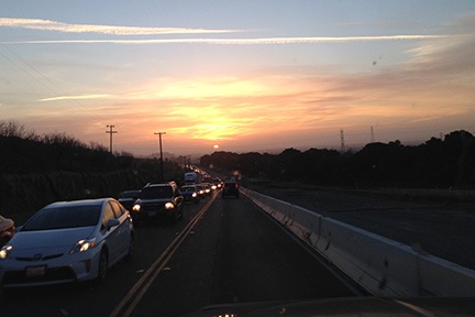
I got to see the sun rise through the marine layer on my way back.
It was a quick drive back. The fog was settling in and, although it was high still over the highway, I could see that Bob had made a good call. As the sun came up through the marine layer, it was pretty obvious that low clouds were filling in the valley.
There was a balloon company setting up beside the freeway at the Winters exit. I called Bob, thinking they might have relocated. He said that was their competition. Before he could give me directions, I told him I knew where to go. I hung up, followed Google’s guidance, and wound up in a field north of town where crews were spreading out three large balloons.
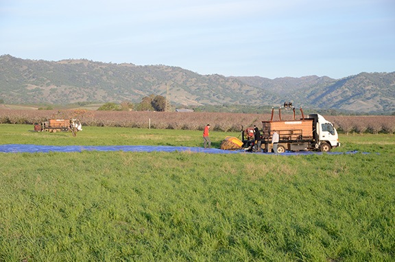
The crews were already beginning to set up the balloons when I arrived.
I’d been ballooning twice before. The first time was at a balloon festival in New Jersey, back in the 1990s, before I’d moved to Arizona. My future wasband had taken his niece and me for a flight. It was a great experience in what was probably considered a medium balloon. I don’t remember there being many people in our basket. I do remember being in a crowd of brightly colored balloons ascending into the sky over southwestern New Jersey farmland. I remember drifting silently on the breeze over people’s backyards while dogs barked. I remember seeing a woman in her bathrobe coming out to ge the morning newspaper. I remember grabbing the leaves off the top of a tree. And I remember the loud rush of gas and flames as the pilot added heat to the balloon envelope to keep us afloat.
The second time had been much more recently and I’d honestly almost forgotten it. It was back in January 2012 when I did a charter job that also involved a balloon. (Long story.) It was a tethered flight out in the desert west of where I lived in Arizona at the time. I blogged about it here.
This was different. This was real ballooning with a real commercial balloon company and pilot. The basket and balloon were huge; the basket could hold 17 people, including the pilot, and the balloon had to be large enough to lift that. The basket was carried to the site in a large truck with a hydraulic lift gate in the back. It took a lot of brute strength to get it down and into position on the ground beside the empty balloon.
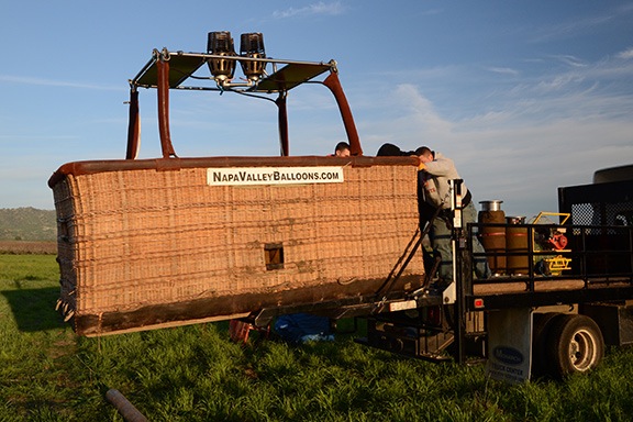
The baskets for these balloons are huge.
I put Penny on her leash and wandered over with my camera to watch.
If you’ve never seen a hot air balloon inflated, here’s how it’s done. They start by spreading out the empty balloon envelope on the ground. They lay the basket on its side beside the bottom of the balloon and fasten the balloon to the basket with a series of ropes and carabiners. Then they put out one or two large fans that are fastened to generators, fire up the generators, and use the fans to start pushing air into the balloons. One or two members of the crew hold the balloon open at the bottom for the air to go in.
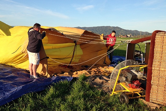
Bob (left) and a crew member hold open the balloon while two large fans begin filling it with air.
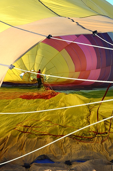
It’s odd seeing people walking inside the balloon as it is inflated.
Meanwhile, crew members work in and around the balloon to make sure all the rigging is properly organized and there aren’t any tangles. I’m sure they do other stuff, too. It’s actually quite odd to see them walking around inside the balloon as it’s being inflated.
At a certain point, the balloon has enough air in it to begin holding its shape. But that air is the same temperature as the rest of the air. The balloon won’t fly. It’s time to add hot air. The pilot lights up the burners and adds fuel to shoot flames into the balloon. The fans and generators are shut off and moved away. As the hot air enters, the balloon starts to rise.
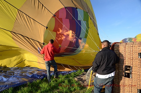
Adding heat to the balloon completes the inflation and makes it rise. You can see the other two balloons also being inflated on the right side of this picture.
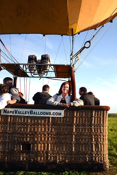
Yes, that’s me in a balloon.
At some point, the balloon has enough lift to bring the basket to the upright position. That’s when it’s time to load up.
The passengers on our flight arrived during the inflation process. Most of them hung back, although a few came closer to take pictures. I snapped a photo of a couple for them. No one else seemed to want to get that close.
The basket had five compartments: one on each corner for passengers and one in the middle that ran from the front to the back of the basket for the pilot and the fuel canisters. Bob and the crew loaded us up with two couples in each compartment except mine; I shared with just two people. It was cosy but not crowded. A member of the ground crew took a photo of me just before we lifted off.
And then we were off the ground, drifting into the sky. Bob snapped a photo with a GoPro he had mounted off the balloon envelope.
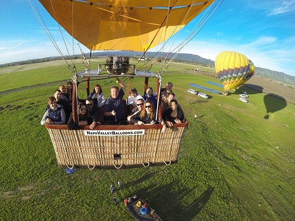
Is this a great picture, or what? Gotta love those GoPros! Bob sent about a dozen shots and I like this one the best.
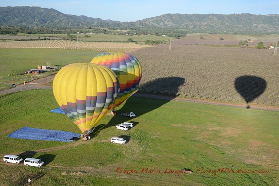
I took this photo of our companions still on the ground as we were lifting off; you can see our shadow on the right.
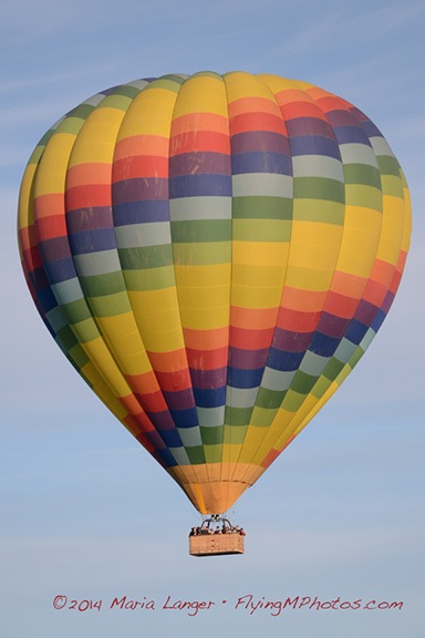
I got this nice shot of one of our companion balloons not long after takeoff.
The flight was wonderful. If you’ve never been in a hot air balloon and you can scrape together the cost of a flight, you really owe it to yourself to do it. It’s a completely novel experience, floating above the ground with this massive structure above your head keeping you aloft. There’s nothing like it.
We were the first ones from our group off the ground, so Bob did most of the navigating — which meant climbing and descending to test the direction of the wind at different altitudes. When he’d find an altitude that took us in the direction he wanted to go, he’d stick to that altitude. We buzzed along in what seemed like a gentle breeze, sometimes reaching in excess of 10 miles per hour. We moved mostly south down the valley with our companions behind us and the balloons from the other company mostly out to the east.
Navigation seems to be the big challenge — and fun — for a balloon pilot. Bob decided to do a “splash and dash” — that’s when the balloon touches down gently in a body of water and then takes off quickly again. He aimed us for Putah Creek, where it ponds up just upstream from a small dam. It was amazing to see him home in on the small pond with nothing to steer with except the wind. We cleared the trees on one side of the pond, descended quickly, and splash! Some water came into the bottom of the basket, soaking our shoes as we climbed out. I looked straight down into the pond and shot two photos of our reflection as we continued drifting south.
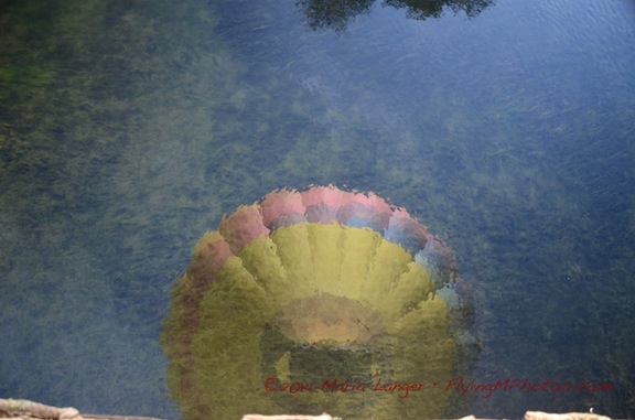
Here’s our reflection just after lifting off. That’s the edge of the basket in the bottom of the shot.
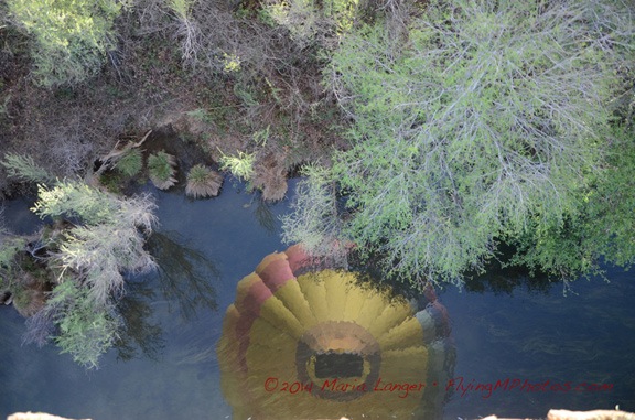
Here’s another shot a few moments later when we were drifting away from the pond past the tops of the trees.

Here’s the second balloon from our group going for a splash and dash. Can you see the reflection of his basket in the pond surface?
We continued drifting mostly south for a while. Meanwhile, the ground crew had packed up and were chasing us on the ground. One of the crew members was driving my truck with Penny inside. Bob talked on the radio occasionally, suggesting potential landing zones. We passed them one by one, occasionally seeing the ground crew below us, my truck easily recognizable by the big white fuel transfer tank on the back.
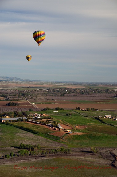
Here’s another shot of our companions.
Eventually, the flight had to end. We’d flown south nearly to I-80. There were a number of office complexes down below us that had plenty of room for landing. We wound up coming in on the grounds of a college campus in a very gentle breeze — so gentle, in fact, that the basket didn’t even tip when landing. We touched down several times — each time, Bob would say, “We’re not done yet.” — before coming to a rest against a curb on an empty cul de sac. Bob began deflating the balloon as the crew came out to grab ropes. The balloon fell gently to the ground ahead of our flight path.
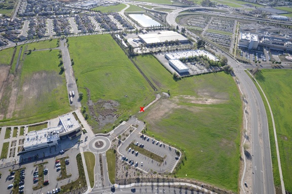
X marks the spot of our landing zone.
The passengers climbed out while the ground crew worked on getting the balloon and basket gathered up and loaded. Bob said goodbye and hurried off with half the passengers in one of the vans. They’d go back to Domaine Chandon for a champagne breakfast. I could have come along, but didn’t see any reason to be a burden. After all, I’d been a guest on the flight. Just experiencing that was enough for me.
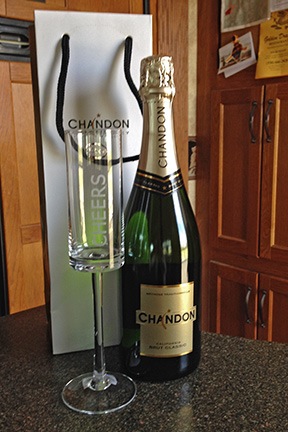
My parting gift from Friday’s flight.
I watched the ground crew work on the balloon for a while, then went back to the truck where Penny was waiting. I let her out for a little walk before we headed out. I stopped in Winters along the way and had a late breakfast at a sidewalk cafe.
I’d forgotten all about the two Chandon bags in the truck, but caught sight of them when I was getting out back at the airport where I’m living. I brought them inside and unwrapped a bottle of Chandon sparkling wine and a glass to toast with.
That champagne is chilling in the fridge right now.

 What I want to share today is what I found in folder labeled “funnies.” They were mostly the kind of jokes that get distributed by email these days. But back in the 1980s, there wasn’t any email — at least not to speak of. Instead, we used copy machines to share the humor with other friends throughout the office. This cartoon is a good example. Someone — maybe even me — whited out the caption and typed in one more appropriate for the workplace. I was a Field Supervisor and I had several whiney people working for me. Beekman was the nearest hospital.
 One of the guys I worked with was a bit of an artist and he would sketch out cartoon characters and scenes of coworkers and workplaces. I found a legal sized sheet of paper covered with his doodles. I recognize Larry, Jim, Seymour, and Frank (the big boss) on this sheet. Can’t remember the names of the others.


 A box in the garage was full of outdated computer media, including complete installation diskette sets for Microsoft Word 6 for Mac, Microsoft Office 4.2 for Mac, and Microsoft Office 95 for Windows. I also found (and discarded about 20 100MB ZIP disks, countless diskettes, and even a SCSI cable for an old PowerBook computer. I threw 95% of it away; I just saved a box of data diskettes on the off chance that I can find a device that can read them.
 Thanksgiving 1996 was probably the best ever. By that point, we’d discovered the U.S. Southwest and were in love with it. I’d gotten a cookbook filled with southwest recipes and we decided to make the entire meal from it. I whipped up a fancy menu with funky fonts and southwest style borders and printed it out for our guests’ reference. Mike set up our dining room table to seat all 14 guests together. I don’t know quite how we pulled it off, but we managed to serve every single dish piping hot. It was the absolute best Thanksgiving dinner I ever had and I’m so proud to have been one of the two people who prepared it. I still occasionally make more than a few items from that menu. (I would have made some this year, but the cookbook was already packed.)
 Later, when we moved to Arizona, we didn’t spend many Thanksgivings with family — although I do recall my mom, stepdad, sister, brother, and sister in law coming out to stay with us for Thanksgiving 2004. That was the first — and I believe only — time that I got to use my good china for a big dinner. My mom had been buying me place settings over the years and I added a few right before they arrived so we had enough to go around. I don’t remember the dinner itself being that special, but I do recall the trip to Torrance, CA, that my sister, brother, and sister-in-law made a few days before to tour the Robinson Helicopter factory.
  Oddly enough, that’s the day they put the shell of my helicopter on the assembly line. And, of course, the visit also gave us the opportunity to get a group photo outside, in front of our house.
 In later years, once our camping shed at Howard Mesa was fully set up for simple living, we had Thanksgiving there at least once, in 2008. It was a bit of a challenge preparing a large meal in the tiny kitchen and we had to be sure to buy a turkey small enough to fit in the apartment-sized oven. I’d planned to make mango chutney (in addition to cranberries with Mike’s mom’s recipe) but had forgotten to bring the mangos. So I used the same recipe to make apple chutney with the apples we’d brought along. Not a bad substitution. It was a quiet Thanksgiving with just the two of us and our dog, Jack. The horses, Jake and Cherokee, roamed around outside. And the sunset was beautiful.
 Penny is an excellent flyer. Not only is she perfectly at ease in any seat — front or back — of the helicopter, but she doesn’t mind curling up for a nap in her travel box when its tucked away under the seat in front of me on an airliner.
 They’d done a lot of work to their house since my last visit and the guest room was completely redone and very comfortable. I set up camp in there for me and Penny. Penny, in the meantime, got to meet their dogs: Emma (a pit bull), Bentley (a hound), and Zoe (a border collie). Of the three, Bentley is the oldest and wasn’t very interested in his tiny house guest. Emma wasn’t really, either. But Zoe and Penny soon became fast friends, sharing the few toys I’d brought along for Penny. Whenever we just hung around the house, they’d play together. In the evenings, when Zoe stretched out on her big bed, Penny would curl up beside her.
 Autumn was in full swing in the Georgetown area and trees were turning color everywhere. The best I saw, however, was right in my friend’s front yard: a small maple tree brilliant with shades of red and orange. Every morning, the sun would come through the other trees, sprinkling this little tree with splotches of golden light. Day after day, I pulled out my camera, attempting to capture the glorious colors. I think this shot came out the best.


 On Sunday, Rod took us in his

 Afterward, we headed down to where Liz works, the
 A few years ago, my husband bought us a pair of Spin Master battery-operated radio-controlled helicopters. They’re tiny little things, maybe 8 inches long made of styrofoam, suitable for indoor flying only. We played with them that Christmas but soon lost interest with frustration. They’ve been lying around the house since then and I just charged them both up and started playing with mine again.
 This isn’t my first RC helicopter. Back in the early 2000s — maybe 2002? — I bought a kit and constructed a gas-powered one. Mine was a
  This year, however, RC helicopters are big. I’ve seen them in mall kiosks all over the place. They’re big electric models with fuselages designed to match real helicopters, both military and civilian. They seem to be a big hit.
 On my little helicopter, forward movement is determined by simple weight and balance; a few push pins in the nose (see photo; sunglasses give you a sense of scale) gives me just the right amount of weight for slow forward flight. One control lever increases or decreases power, like a collective/throttle combination. Another lever points left or right like a limited action cyclic. Tail rotor trim can be avoided if set right. It’s pretty challenging and, fortunately, pretty sturdy. I crash-land almost every time I fly it, but I am getting better.