With just two wire near misses, one do-over, and some green on my tail rotor.
Yesterday was the big day. After being on standby for about three weeks here in Washington State, I finally got to dry some cherries.
We were watching the radar via the Internet and saw what looked like a little “perfect storm” converging on the town of Brewster, just up the river from my motel in Pateros. Convective activity to the west, east, and south all moved toward each other, as if they were magnetically drawn together. But it was the thunderstorm cells from the southeast that actually hit the town, one after the other. The wind kicked up, lightning flared, and whitecaps appeared on the normally calm lake surface. Although not a drop fell on us eight miles downriver, we could clearly see that Brewster was getting dumped on.
My “boss” called. “It’s raining like hell in Brewster,” he said. One of the growers had called him to report in. I was put on “active standby.” Since it was only around 6 PM, that meant there was a pretty good chance I’d fly.
We waited, watching the storms move through. An Enstrom helicopter came upriver and slowly settled down over an orchard just south of the downpour, upriver from our position. Beyond him, the sky was dark gray and forked lightning bounced from cloud to cloud. He wasn’t there long. He departed to the southeast.
My phone rang again at about 7 PM. “I’ve got some for you,” the boss said. “Got a pen?”
“I’m getting one,” I told him, hurrying back to my motel room.
He listed five orchards. I wrote down their names. They were all within 10 miles of each other, starting just upriver from my position. By that time, the wind had calmed. Although it looked as if it might still be raining in Brewster and beyond, it had apparently stopped over my orchards.
“Okay,” I told him, “I’ll get started.”
I changed into my flight suit and put on socks and sneakers. Then I went down to the helicopter with Mike. We pulled off my door and the tie-downs. The motel guests saw what we were doing. There were some kids and they started asking questions. Mike told them he’d answer all the questions when I was gone.
I started up the helicopter and organized all my gear out on the passenger seat while I was warming up: my handheld GPS with coordinates for all the orchards and a looseleaf binder with marked-up aerial photos of all the orchards. I plugged my cellphone into the device I’d bought to enable cellphone communication in flight. I tuned the radio into the frequency Mike would be monitoring on the handheld: 123.45. Then I finished my startup process. I was about to take off when my cellphone fell off its mount and the communication plug game loose. I set it up again, amazed at how much it was vibrating while I was on the ground. Then I took off.
I was climbing through about 200 feet, heading upriver, when my phone rang. It was the boss. “C called and says its raining there,” he told me.
C was the second orchard I’d be drying. (I won’t use real names here for various reasons.) It was across the river from the first and not far from where I’d seen the Enstrom do some drying at least 30 minutes before.
I asked him what he wanted me to do. He responded that he was just letting me know. I ended the call. I was already arriving at the first orchard, M.
 M’s orchard was snuggled into a strip of land between a rocky bluff and a road. The rows stretched across the field at an angle that went downhill toward the river. I got down low and flew around two of the main block’s three sides to get a handle on how I’d tackle the job. At that time, I also looked for obstacles. The only power lines were on the other side of the road and were not a factor. Other than that, there were three tall PVC poles that stuck up about 5 feet above the tree tops in various locations and, of course, that rocky bluff.
I started on one end of the block and worked my way down the first row, from the rocks to the road. I pivoted with a pedal turn over the road, pleased that the wind wasn’t going to fight me. Then I worked my way up the next row. At the top, I sidestepped to the next row, made a 90° pedal turn, and began flying sideways down the row. When I was sure my tail would clear the rocky bluff, I completed my turn with another 90° pedal turn and continued down the row.
I repeated this process at the top and bottom of each row, noticing a few things as I flew:
- There was enough wind to push the downwash I generated to the southeast side of the helicopter. So as I flew over one row, I was really drying the row next to it.
- When I flew downhill, I flew higher yet faster than when I flew uphill. Both made perfect sense, although the speed was sloppy flying. I had to fly higher on the way downhill to prevent my tail rotor from tangling in the trees uphill, behind me.
- It was extremely difficult to see the rows of trees. They were big and bushy and, from the air, there wasn’t much space between them. I had to rely on occasional views of the reflective material on the ground to remain lined up.
- I was generating a lot more downwash than I expected. I may have been flying a little low.
I was about a third of the way through the field when it started to rain. Keeping in mind that it was my job to dry the cherries, it didn’t make much sense to dry them when it was still raining. So I decided to call it quits and work on the next field, Orchard C. I flew across the river. It was still raining there, but much lighter. As I did my reconnoissance around the field, the rain just about let up. I settled down over the first row of trees and started drying.
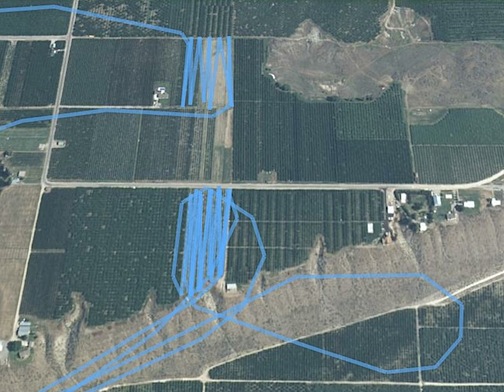
 This block was also on a slope, but a much gentler one. Its main obstacles included a tall fan in the middle of the field and a set of powerlines that ran across the upriver side of the block. Down below were numerous white picking buckets like the 5-gallon plastic “cans” filled with paint that you might buy to paint your house. The helicopter’s downwash sent most of them flying — in fact, if anyone had been down there, he would have been in serious danger. There were also some ladders, most of which were lying on the ground. The ladders must have been sturdy because my downwash did not knock over any of the ones that had been left standing.
I went up and down the rows, being careful to avoid the wires at the end of each row when I made my turn. When I got to the rows closest to the fan tower, I simply sidestepped around it, double-drying a set of trees a bit farther away and pretty much avoiding the ones closest to the tower. But I think that my altitude — 10 or so feet off the top of the trees — spread the downwash around enough to get most of the trees. I wasn’t going to get fancy with the maneuvers I’d learned in May — not on my first flight, anyway. I finished that field in about 20 minutes, then climbed and crossed the river. Then I restarted the first field, Orchard M.
In the meantime, I could hear other pilots on the radio. There was a group working out of Brewster Airport. One of them was flying a JetRanger; another was flying a big Sikorsky. They were working together, somehow. I didn’t see them. Later, I did see a few Sikorskys hovering over fields in Brewster. They looked like big bugs hovering 50 feet off the trees.
I finished the main block of Orchard M and repositioned over a tiny block of younger trees farther down the hill. The trees were smaller and I found that I could dry two rows with one pass. I finished them off quickly and pulled up, heading toward my next orchard. I’d finished 23 acres (including the re-do) in a little more than an hour. Not exactly fast, but with ferry time factored in, it wasn’t bad.
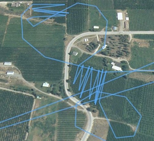
 My next orchard was full of surprises. Only 3 acres in size, it was shaped kind of like an uppercase letter D, but backwards from my point of view. The rounded edge was lined with seven very large pine trees. Where the trees ended, a set of power lines completed the border of the field. There was a house at the top of the D and another house not far away on one of the rounded edges. I soon realized that I’d have an audience for my flight as I saw folks gathering along the deck of the second house.
As I approached the orchard and got ready to settle down to tree top level, I saw two areas where the tree branches were going wild, as if Big Foot were walking among them. It turned out to be ground blowers that the grower was using to get the drying process started. The first time I got into the wake of one of these blowers, I got pushed around quite a bit, but when the grower realized I was overhead, he repositioned to one end of the orchard and shut down.
Meanwhile, I’d begun drying. In this particular orchard, due to the shape of the block and the size of the trees, it was impossible to see the rows. I’d fly down what I thought was one row, make a complex turn at the end to avoid the big pine tree, and get ready to start up the next row only to realize that I’d either already done that row or I’d missed a bunch. Fortunately, my downwash was covering more than just one row at a pass and I had to satisfy myself (and the grower) with that.
Near the end of the block, while making a difficult turn to avoid a big pine, I heard a loud noise and felt the helicopter shudder. At first, I thought my tail rotor had struck the tree and I shot forward to clear it. But the helicopter seemed to fly fine and, as I continued flying, I figured I must have just overflown one of the bird cannons. Erik had warned that it would “scare the shit out of you the first time you heard one.” He wasn’t kidding.
As I neared the very last row of the block, I realized that it was uncomfortably close to the powerlines I’d noticed there before. Still a little frazzled by the loud noise I’d heard only minutes earlier, I decided I’d done enough. I lifted up and started toward my next orchard.
I’d climbed to about 250 feet to cruise to the next orchard when I consulted my list of orchards to do. I knew I had only two left. That’s when I realized that I’d forgotten to do the one near to the big D. The only problem I had with that orchard was that although I had a photo of it, I’d never actually seen it in person from the air. We’d skipped it during my preview flight and I didn’t have its coordinates. That meant I had to find it from the air while in flight, using the photo as my guide.
It’s not as easy as it sounds. There were orchard blocks all over the place below me. I had to get down low to look at the fruit on the trees. Most of them seemed to be apples and pears. When I finally found a cherry block, I assumed I had the right one and settled in over it. It was a block of young trees in a very easy layout with no obstructions. Nice and calming after the previous block.
I noticed my phone ringing and reached out to answer it. It was Jim, another pilot who is based in Chelan. “Dan’s on the phone with the grower. He says you’re dying the wrong block.”
I found that hard to believe. How many cherry blocks were out there?
“He says to go closer to the gray house.” What followed were instructions relayed by phone to get me in the right place. It was a lot like the game kids play when they’ve hidden something and give instructions to find it. “You’re getting warmer, it’s to your right, now it’s behind you.” You get the idea. I finally homed in on it. Jim had complained that he couldn’t understand me on the phone so we didn’t get the goodbyes done properly before I disconnected. I wasn’t about to let go of the collective while hovering 10 feet over cherry trees at 10 knots.
The block was easy and went quickly. I was definitely able to dry two rows at once and that really sped things up. I was making up for my earlier slow flights. As I flew back and forth, I caught sight of the people on the gray house’s porch supervising. Then I was done and climbing out for my last orchard.
I had the coordinates for that, as well as the photo. I should have followed the GPS until I got a bit closer before descending to look for the fruit on the trees. I was cruising over orchard blocks at about 50 feet when I saw a set of power lines crossing the road about 150 feet in front of me. I pulled pitch and brought the cyclic back smoothly. Two men walking on the road stared as I climbed almost straight up to clear the wires. Whew! Learned my lesson. I followed the GPS the remaining 3/4 mile to the field.
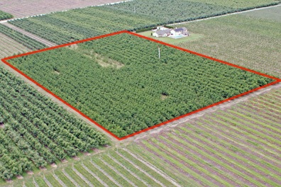
 This last block also had blowers going. It was a nice 6-aqcre block with no wires and just one fan tower. I settled down 10 feet over the space between two rows of relatively young trees and followed them to the end at about 10 knots. When I got near the end, I spotted the grower watching me from a seat on an ATV. He gave me a thumbs up.
I can’t tell you how good that simple gesture made me feel. It was my first day on the job and I’d made someone — a man who had waited more than 90 minutes for me to arrive — happy. Maybe I’d saved his crop. Who knows? But it sure made me feel good as I cruised over every other row of trees, drying the whole block in about 15 minutes.
By this time, it was nearing 9 PM. The sun would be setting shortly. The storm had cleared out and the setting sun was casting an orange light over the Columbia River and mountains on the east side. It was beautiful. I climbed up to 400 feet and pushed a few buttons. Soon I had the boss on the phone. I told him I was done and asked if there were any others. He couldn’t hear me. Not at all. He told me to do the one I’d just finished, but if the grower waved me off, I should forget about it. But the grower had given me a thumbs up. I was done. Since I couldn’t communicate, I hung up. I figured I’d call him from the ground.
I got Mike on the radio and told him I was coming in. He met me on the lawn beside the motel, holding my door. I shut down and we buttoned the whole thing up, adding fuel to top the tanks and putting on the tie-downs.
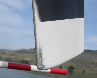
 That’s when I got a good look at the tail rotor. Although it was not damaged beyond a bit more paint worn off, it did have signs of something green on each blade. Maybe that loud noise wasn’t a bird cannon after all.
I’d flown 2.1 hours. Although I probably should have done the work more quickly, I now know what to expect and how to get the job done more efficiently.
I can’t wait until the next rain!
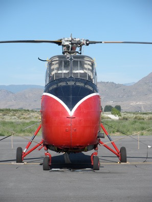 This is the ship I’d most like to fly. It’s a Sikorsky and I think it’s an S55. It has a radial engine and, a few days later, I had the pleasure of watching it start up and fly away while I was waiting on the ramp in my helicopter for my dispatcher to send me to an orchard.
 This is another Sikorsky. Not quite as pretty, but also used for agricultural work. They dry cherries with these. I saw this one in flight, hovering about 50 feet over an orchard. I think there’s so much downwash that they can just hover in one place and dry the whole orchard. (Which is a good thing, because they cost a fortune to fly.)
 Were you looking for a Huey? How about this one?
 Here’s another helicopter you don’t see every day: a Hiller. This is one of two Hillers that supposedly came down from Canada to dry cherries.
  Here’s the other Hiller in an artsy head-on shot. I love the old helicopters with the big glass bubbles — but I sure wouldn’t want to fly one in the Arizona sun. A buddy of mine in Arizona has one and I think he’s nuts.
 And here’s the pair of them, parked side by side.
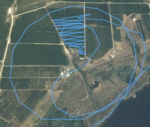
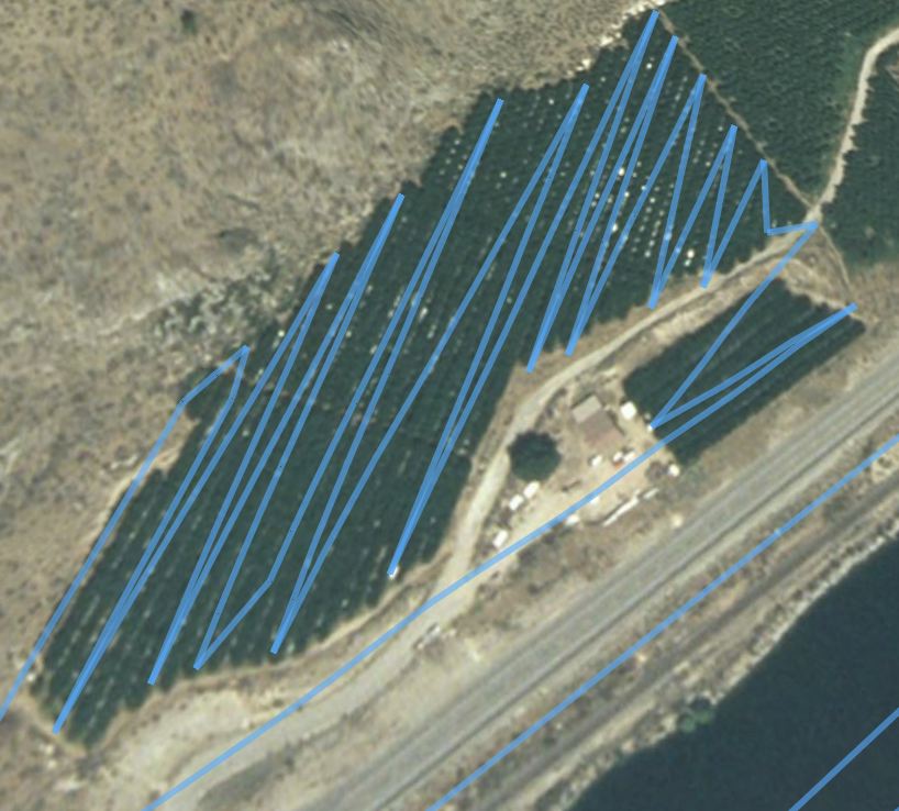
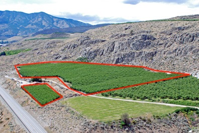 M’s orchard was snuggled into a strip of land between a rocky bluff and a road. The rows stretched across the field at an angle that went downhill toward the river. I got down low and flew around two of the main block’s three sides to get a handle on how I’d tackle the job. At that time, I also looked for obstacles. The only power lines were on the other side of the road and were not a factor. Other than that, there were three tall PVC poles that stuck up about 5 feet above the tree tops in various locations and, of course, that rocky bluff.
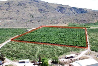 This block was also on a slope, but a much gentler one. Its main obstacles included a tall fan in the middle of the field and a set of powerlines that ran across the upriver side of the block. Down below were numerous white picking buckets like the 5-gallon plastic “cans” filled with paint that you might buy to paint your house. The helicopter’s downwash sent most of them flying — in fact, if anyone had been down there, he would have been in serious danger. There were also some ladders, most of which were lying on the ground. The ladders must have been sturdy because my downwash did not knock over any of the ones that had been left standing.
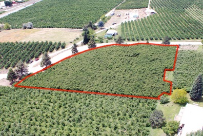 My next orchard was full of surprises. Only 3 acres in size, it was shaped kind of like an uppercase letter D, but backwards from my point of view. The rounded edge was lined with seven very large pine trees. Where the trees ended, a set of power lines completed the border of the field. There was a house at the top of the D and another house not far away on one of the rounded edges. I soon realized that I’d have an audience for my flight as I saw folks gathering along the deck of the second house.
 This last block also had blowers going. It was a nice 6-aqcre block with no wires and just one fan tower. I settled down 10 feet over the space between two rows of relatively young trees and followed them to the end at about 10 knots. When I got near the end, I spotted the grower watching me from a seat on an ATV. He gave me a thumbs up.
 That’s when I got a good look at the tail rotor. Although it was not damaged beyond a bit more paint worn off, it did have signs of something green on each blade. Maybe that loud noise wasn’t a bird cannon after all.