I’m too busy to blog, so don’t expect much here. I finished a book and immediately flew to Ventura, CA to record a video course. I’m in a soundproof booth all day long. Then I go to my hotel and sit at a desk in front of two laptops, preparing for the next day’s recording sessions.
I’m even too busy to tweet!
On Saturday, I fly home. Then, on Sunday, I start another 6-day helicopter excursion.
Since I apparently haven’t posted anything for at least a week, I thought I’d send this just to let everyone know I’m still alive.
Can you still say you’d rather take a tour in an airplane?
Just thought I’d take a moment to share this photo with blog readers. It was taken by Bryan using my Nikon D80 and 10.5mm fisheye lens. He was sitting in the back seat; I was sitting up front with Ryan at the controls. Bryan snapped this shot from between the two seats as we were flying over Lake Shasta in northern California.
Yes, I know we look a bit distorted. That’s the lens in action. But can you get an idea of the view? Huge front bubble window, big side windows. Even the back seats have a great view.
Yet people still take tours of places like the Grand Canyon in airplanes, where they’re lucky to get a limited view out one window.
Cross-Country, Defined
For those of you who are not pilots, allow me to explain the term cross-country as used by a pilot. A cross-country flight is basically any long flight with a landing a certain minimum distance from your starting point. For airplane pilots, it’s at least 50 miles. For helicopter pilots, it’s at least 25 miles. So while this blog entry discusses a very long cross-country flight, we did not fly all the way across the country.
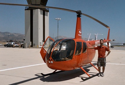
This past Thursday and Friday, I flew by helicopter with two other helicopter pilots, Ryan and Bryan, from Wickenburg, AZ to Boeing Field in Seattle. Bryan and Ryan did just about all of the flying. I sat up front being a nervous passenger when we were near the ground and playing with the radio and GPS. Brian let me make most of his radio calls on the first day, but I didn’t get to do much of that the second day.
It was a mutually beneficial journey. I needed to get the helicopter from Arizona to Washington State. Ryan and Bryan were both CFIs who wanted to build time in an R44 helicopter. It was way cheaper for them to fly with me on this trip than to rent an R44 from a flight school. There was also the added experience of planning and executing a flight through unknown terrain, with fuel stops and an overnight stop along the way. And the money they paid to fly my aircraft helped me cover the cost of this very long and very expensive helicopter flight. Win-win.
A very cool but very helicopter-unfriendly fuel island at Corona Airport in California.
Our flight path took us west, with Bryan at the controls, along state route 60 to I-10, across the Colorado River, and then along I-10 through Bythe, Chiriaco Summit, Palm Springs, and Banning; then back on 60 past March to Riverside on the 91. We stopped at Corona for fuel at what’s likely the coolest but most helicopter-unfriendly fuel island in the world. (We didn’t notice the separate fuel island more suitable for helicopters until we’d stopped and shut down.)
Here’s a video of our transition along the California coast through the LAX airspace on the Shoreline transition route. You might want to turn down the sound while playing it; lots of helicopter noise.
Then Ryan took us west on 91 through the airspace for Fullerton and Long Beach, with a Torrance low pass. (Robinson has entirely too many helicopters waiting for owners on its ramp and in its delivery room.) He then got clearance for the Shoreline helicopter transition of LAX space, which requires the pilot to drop to 150 feet 1/4 mile offshore to pass under LAX departing traffic. We continued following the coast up past Santa Monica, Pacific Palisades, Malibu, Oxnard, Ventura, and Santa Barbara. By then, the marine layer was moving in, so we went inland for a bit. Eventually, we reached San Luis Obispo (and the chatty controller) and stopped for fuel and lunch.
Here’s Ryan on the ramp at San Luis Obispo before departure northbound. I shot this one with my Blackberry’s camera, so pardon the quality.
Bryan was back at the controls for our departure northbound. After a very close call with a large bird, we followed the path of Route 101 northbound. Most of the route was up a riverbed in a very pleasant valley. We got to Salinas and realized that any coastal route would be out of the question — the marine layer was creeping in even there. So we headed over the mountains, eventually ending up in the western part of California’s Central Valley. We stopped for fuel at Byron.
Ryan took over and we continued north over Rio Vista and Yolo, finally hooking up with I-5. We followed that through endless farmland — much of it flooded for a crop that apparently needs lots of water — over Willows Glen and Red Bluff, with more than a few crop-dusters flying nearby at altitudes far below ours. We stopped for the night at Redding, tied down the helicopter, and got a hotel shuttle into town.
We’d flown 8.8 hours.
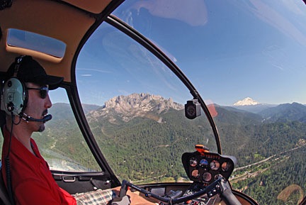
Ryan at the controls as we near Mt. Shasta in northern California.
The next morning, we were back at the airport at 9 AM, preflighting and getting ready to go. Ryan would start the flight. We headed north along I-5, over Lake Shasta and past Mount Shasta, which was snow-covered and beautiful. We were now past Central Valley’s vast farmland and up in the mountains. We flew past Weed, Siskiyou Co., Rogue Valley/Medford, and Grant’s Pass. Much of this flying was in canyons, along the same route as I-5 and a train line.
Things turned a bit iffy as I-5 swung to the east. We were hoping to go north and catch it on the other side of some mountains, shortening our route a bit, but clouds sitting on the tops of those mountains made that a bit uncertain. So we dropped altitude, slowed down, and followed I-5. Ryan flew while Bryan and I kept a sharp lookout for the power lines we knew — from both chart and GPS — were ahead. We weren’t that low and there wasn’t any real danger, but we were certainly not coming out of that canyon anywhere except the I-5 corridor. We passed the powerlines with plenty of room. The road descended into a valley and we stayed up beneath the cloud bottoms. Eventually, the sky cleared. We continued along I-5 past Myrtle Creek and Roseburg and stopped at Cottage Grove State for fuel and lunch.
Then it was Bryan’s turn again. We continued up I-5 past Hobby, Albany Municipal, and McNary. Then we headed northwest over Sportsman’s, Hillsboro, and Scappoose. We crossed the Columbia River and headed north on I-5 again over Kelso Longview and Olympia, with nice views of Mount St. Helens and Mount Rainier in the distance. Then on to Bremmerton, where we stopped for fuel. We probably had enough to make the last 20 minutes, but why take chances?
Zero-Mike-Lima on the ramp at BFI. Another Blackberry photo. And yes, that’s Mt. Rainier in the background.
I flew the last leg with Bryan up front to handle the radio and give me directions. It was only a 15-minute flight, but the airspace was complicated, so I was grateful for the help. I set the helicopter down sloppily in the parking area. We’d flown a total of 14.4 hours.
It was a great flight. We saw so much that most of it is just a blur in my mind. With luck, these photos and videos will help me remember the trip for a long time to come.
Many thanks to Ryan and Bryan for accompanying me on this trip. I hope they learned a lot about cross-country flying.
I’m back in Ventura again, working hard on a new training video for Lynda.com. The schedule is very tough this time around and at the end of the day, I’m absolutely exhausted.
But tonight, I took a few minutes to walk along the path around the harbor. I did it around sunset, waiting for a crescent moon that never appeared. And then I did it again after dinner.
And I took some photos of the samedamnboats I always take pictures of when I’m in Ventura.
This is a night shot taken not far from my room. The bright light in the sky is Venus. This was a long exposure, a full stop “overexposed” — at least as far as my camera’s meter was concerned.
I used my new Slik tripod for this shot. It’s designed for smaller cameras, but it held up my digital SLR with its fat lens pretty well. I like the pivoting head and really wish I’d gone the same route with the Manfrotto I got for more serious photo work.
I was driving down the California coast, looking for a place to stop for breakfast — preferably with a view of the ocean — when I saw a sign for Paradise Cove. I followed the arrow down a narrow road that wound down to the ocean. There was a right turn into a trailer park, but if I went straight, I’d end up in a parking lot on the ocean. A sign warned that parking was $20, but only $3 if you got your parking ticket validated in the restaurant and stayed for less than 4 hours. Ahead of me was a funky little oceanfront restaurant with a handful of cars parked in front of it. I drove through the gate and parked.
It was a typical seaside restaurant — the kind you can imagine filled with people in bathing suits, eating fried clams, with sand and flip-flops on their feet. (That’s my east coast seaside experience talking.) But that Saturday morning was partly cloudy and unseasonably cool for southern California. The main dining room was empty. I was escorted into a kind of sundeck room with big windows facing the ocean. Although all the window tables were full, the waiter kindly sat me at a huge table nearby, where I could enjoy the view as well as the activity going on around me.
I checked out the menu, eager for a big, hot breakfast. I didn’t plan to eat again until after my flight arrived in Phoenix later that evening. Some items on the menu interested me, but it was the eggs benedict I asked the waiter about.
“Are they good?” There’s nothing worse than bad eggs benedict when you’re expecting decent eggs benedict.
“Very good,” he assured me.
I settled down to wait for my breakfast. There was nothing much going on outside the window. Gulls flying around, a few people walking out on the obligatory but short pier. It was mostly dark and cloudy over the ocean, but the sun was breaking through here and there. I watched my fellow diners get their breakfasts delivered. Everything looked outrageously good.
When my breakfast arrived, it looked good. On the plate were two eggs benedict, a good sized portion of roasted potatoes, and some melon slices. I nibbled a potato. It was cooked to perfection. And then I tasted the eggs benedict.
I’ve had eggs benedict in a lot of places — including a lot of fancy and expensive hotel restaurants. But these eggs benedict were the best I’d ever had in my life. It may have been the fact that the eggs were cooked perfectly — whites cooked, yolks still runny. Or the fact that the english muffins beneath them were fresh and not over-toasted. But it was probably because the hollandaise sauce was light and airy and obviously freshly prepared from scratch — not some thick yellow crap from a mix.
You like eggs benedict? Go on out to the Paradise Cove Cafe in Malibu and get some.
I was just finishing up my breakfast when a man about my age came in with two elderly ladies. They got a table by the window near where I was sitting. I watched them, trying not to look obvious about it, recognizing something about them. It came to me slowly. He was the grandson taking his grandmother and her friend out to breakfast.
They reminded me so much of all the times I’d taken my grandmother out to breakfast. This may have been because the woman had the same New York accent my grandmother had. She also spoke rather loudly, had trouble hearing her grandson, and asked the waiter all kinds of questions. She was concerned about whether she’d have to pay for a refill of her “mocha” — a simple mix of coffee and hot chocolate prepared by the waiter. She praised the waiter extensively about how well he’d prepared that mocha for her. The other woman was quieter but seemed to have the same accent. The grandson was attentive but, on more than one occasion, obviously embarrassed.
I knew exactly how he felt.
Before I left, I got up to say hello to them. I discovered that the women were from the Bronx — the same area as my grandmother. The quiet woman was the grandmother’s sister. She complemented me on the way my blue earrings made my eyes look bluer. I could easily have chatted with them all day.
Afterwards, I went outside and took a walk on the pier. I took a photo looking up the coast (shown here) and another looking down the coast (shown below). Amazing that these two photos were taken only moments apart, isn’t it? But the weather was variable and moving quickly. A huge storm front was moving into southern California that would dump rain on the low elevations and snow on the higher ones.
Paradise Cove and places like it are part of the reason I like to travel alone. When you’re traveling with companions, every stop has to be debated and measured. No one ever wants to say, “Let’s stop here and check it out,” because no one wants to be responsible if the place turns out to be rat hole. As a result, opportunities to visit interesting places are missed. Instead, a trip is a long string of predetermined “must see” places, visited one after another with few spontaneous stops along the way.
There was magic at the Paradise Cove Cafe — at least for me that morning. If I’d been with someone else — someone anxious to eat breakfast before starting the drive or satisfied with a chain restaurant for a meal — I would have missed that magic.
I also would have missed out on photo opportunities. When I’m on the road by myself, I stop more often to look at what’s around me and, if I can, take pictures. On this particular Saturday, all I had with me was my little Nikon CoolPix point-and-shoot, but I put it to good use. The weather was a mixture of thick clouds and blue sky. It was the kind of place and day that calls out to photographers. The photos I’m able to include with this blog entry will help me remember this day. (I even took a stealth photo of the grandson/grandmother/aunt outing with my Treo, although I won’t publish it here.)
Anyway, I walked back to my rental car, fired it up, and paid my $3 parking fee on the way out. It had been well worth the money.


 And I took some photos of the
  And went inside the
  Afterwards, I went outside and took a walk on the pier. I took a photo looking up the coast (shown here) and another looking down the coast (shown below). Amazing that these two photos were taken only moments apart, isn’t it? But the weather was variable and moving quickly. A huge storm front was moving into southern California that would dump rain on the low elevations and snow on the higher ones.
 There was magic at the Paradise Cove Cafe — at least for me that morning. If I’d been with someone else — someone anxious to eat breakfast before starting the drive or satisfied with a chain restaurant for a meal — I would have missed that magic.