Something different, something fun.
As Thanksgiving approached this year, I was faced with the prospect of not having anyone to spend it with for the first time in my life.
Past Thanksgivings
When I was a kid, it was a big family event that often involved my grandparents, aunt and uncle, and cousins. I can remember more than a few Thanksgiving dinners in the tiny dining room of our house in Cresskill, NJ. For at least part of that time, the dining room table was a pool table with a piece of plywood on top and a nice linen tablecloth on top of that. (Not quite Beverly Hillbillies.) I distinctly remember being able to fool around with the pool balls while siting at the table. Of course, my grandmother always insisted on taking photos of the table all set with my mom’s best china. And a closeup of the turkey before carving. I wonder where all those photos are today?
Later, after Mike and I began living together, we’d occasionally host Thanksgiving dinner at our Harrington Park, NJ house. It was a big deal for everyone to travel out our way — most of his family and even some of mine were in New York and had to deal with the horrendous traffic. But we tried hard to make it worth the drive. 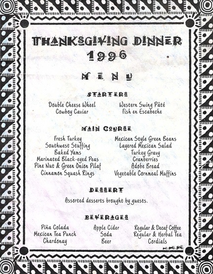 Thanksgiving 1996 was probably the best ever. By that point, we’d discovered the U.S. Southwest and were in love with it. I’d gotten a cookbook filled with southwest recipes and we decided to make the entire meal from it. I whipped up a fancy menu with funky fonts and southwest style borders and printed it out for our guests’ reference. Mike set up our dining room table to seat all 14 guests together. I don’t know quite how we pulled it off, but we managed to serve every single dish piping hot. It was the absolute best Thanksgiving dinner I ever had and I’m so proud to have been one of the two people who prepared it. I still occasionally make more than a few items from that menu. (I would have made some this year, but the cookbook was already packed.)
 Later, when we moved to Arizona, we didn’t spend many Thanksgivings with family — although I do recall my mom, stepdad, sister, brother, and sister in law coming out to stay with us for Thanksgiving 2004. That was the first — and I believe only — time that I got to use my good china for a big dinner. My mom had been buying me place settings over the years and I added a few right before they arrived so we had enough to go around. I don’t remember the dinner itself being that special, but I do recall the trip to Torrance, CA, that my sister, brother, and sister-in-law made a few days before to tour the Robinson Helicopter factory.
  Oddly enough, that’s the day they put the shell of my helicopter on the assembly line. And, of course, the visit also gave us the opportunity to get a group photo outside, in front of our house.
Other Thanksgivings in our Wickenburg home included friends who weren’t fortunate enough to have someone else to spend Thanksgiving with. I remember one Thanksgiving when we invited a friend, his girlfriend, and his dad to join us for dinner. I think it was just the five of us, but our guest brought a dozen bottles of wine. No, we didn’t drink them all — but it sure was a fun meal.
 In later years, once our camping shed at Howard Mesa was fully set up for simple living, we had Thanksgiving there at least once, in 2008. It was a bit of a challenge preparing a large meal in the tiny kitchen and we had to be sure to buy a turkey small enough to fit in the apartment-sized oven. I’d planned to make mango chutney (in addition to cranberries with Mike’s mom’s recipe) but had forgotten to bring the mangos. So I used the same recipe to make apple chutney with the apples we’d brought along. Not a bad substitution. It was a quiet Thanksgiving with just the two of us and our dog, Jack. The horses, Jake and Cherokee, roamed around outside. And the sunset was beautiful.

Dealing with the Prospect of Having Thanksgiving Alone
Although I’d hoped to have the divorce settled long before Thanksgiving so I could get on with my life, by October, I realized that was not going to happen. Apparently, my soon-to-be ex-husband and I had different ideas of what the word “fair” meant. So I slowed down on my high-speed packing and prepared to stay, probably through Christmas (and maybe as long as through March). And that’s when I realized that I might not have anyone to spend Thanksgiving with.
I was going to be like one of those unfortunate people that we’d taken in for Thanksgiving in the past.
All of my friends without family in the area were traveling. Some were skipping dinner altogether. As the day came closer and closer, it seemed more and more likely that I’d have Thanksgiving dinner alone — just me and Penny the Tiny Dog. At first, I was okay with that — after all, I’d lived mostly alone every summer for the past five years. And I’d spent plenty of time alone when my soon-to-be ex was spending weeks in New Jersey or weekdays in Phoenix. But for some reason, Thanksgiving was different.
I realized that it bugged me that I’d be alone on Thanksgiving for the first time in my entire life — especially after 29 consecutive years spending it with the man who would be spending his day with my replacement instead of me.
The emotional pain from that realization was fierce.
Meanwhile, I’d gotten two Thanksgiving invitations that required travel. One was to my brother’s house in New Jersey. I really didn’t want to take that long trip for such a short stay. The other was to my friends Rod and Liz’s house in Georgetown, CA. I gave the situation a lot of thought. And on the Monday before Thanksgiving, I finally decided and bought my round-trip tickets for Sacramento.
Flying Commercial with Penny the Tiny Dog
I’d planned a six-day trip, arriving on Wednesday before Thanksgiving and departing on Monday, after the holiday crowd had gone home. I decided to keep things simple and pack a big bag, which I would check. I’d carry Penny on board in her travel box.
 Penny is an excellent flyer. Not only is she perfectly at ease in any seat — front or back — of the helicopter, but she doesn’t mind curling up for a nap in her travel box when its tucked away under the seat in front of me on an airliner.
I usually keep her on her leash until just before boarding time. We’ll walk through the terminal and she’ll wait patiently while I grab a latte. Then we’ll hang out by the gate until they start boarding. Everyone loves her — she’s cute and funny to watch, especially when she’s playing with her toys. When we’re ready to board, I’ll coax her — admittedly, sometimes forcefully — into her box and close the door. Then we get in line, board the plane, and I tuck her under the seat. I don’t usually even check on her in flight. She really does just curl up and go to sleep.
When we get off the plane, I carry her out in her box and then get her on her leash as soon as we’re clear of the crowds getting off the plane. Occasionally, after a long flight, she finds a place in the terminal to take a leak or a poop. You can’t really blame her — it’s not as if they have restrooms for dogs. (SEATAC has a pet area that is so stinky, even Penny wouldn’t go in.) I’m prepared for that eventuality with paper shop towels and poop bags, so it isn’t a huge deal. Arriving from Phoenix in Sacramento was accident-free. While waiting for my luggage, I took her outside to a grassy area where she was able to take care of business before my friends arrived to pick us up.
In case you’re wondering, the airlines do charge a fee for carry-on pets. Alaska Airlines charges $100 each way; US AIrways, which is what I took to Sacramento, charges $125 each way. The pet case counts as your carry-on bag, so unless you travel very light, you’ll likely have to spend another $25 to check your bag, too. I think this is outrageous. In fact, Penny’s return fare cost more than my seat on the plane for that flight. According to the check-in folks, I could buy a seat for her. I suspect that’s bullshit, but I’ll try on our next trip.
Although I prefer a mid-sized dog — I sorely miss my border collie, Charlie, and his border collie/Australian shepherd mix predecessor, Jack — I admit that it’s a lot easier to travel with a tiny dog. And she really does seem to like to travel with me. A real adventurer!
Our California Stay
The weather was just clearing out when I arrived — low clouds after some morning rain were burning off. The weather turned perfect and stayed that way straight through our departure on Monday.
My friends picked us up in their old but meticulously maintained Land Rover and whisked us away for a late breakfast. It was great to see them and we talked about all kinds of things. I brought them up to date on the divorce bullshit, even though I’d purposely neglected to read the latest correspondence from opposing counsel. (I didn’t want more bullshit to ruin my weekend and it turned out to be an excellent decision.) Then we climbed back into the car where Penny was waited and headed up to Georgetown, in the foothills of the Sierra Nevada Mountains.
Rod and Liz live in a great little house on a big piece of land south of Georgetown. Georgetown is a tiny town with even fewer services than Wickenburg, so they do most of their shopping and dining out in either Placerville or Auburn. Their area is quiet and the huge front lawn — which, by the way, is large enough to land a helicopter on — is shielded from the main road by a barrier of tall trees and a creek.
 They’d done a lot of work to their house since my last visit and the guest room was completely redone and very comfortable. I set up camp in there for me and Penny. Penny, in the meantime, got to meet their dogs: Emma (a pit bull), Bentley (a hound), and Zoe (a border collie). Of the three, Bentley is the oldest and wasn’t very interested in his tiny house guest. Emma wasn’t really, either. But Zoe and Penny soon became fast friends, sharing the few toys I’d brought along for Penny. Whenever we just hung around the house, they’d play together. In the evenings, when Zoe stretched out on her big bed, Penny would curl up beside her.
 Autumn was in full swing in the Georgetown area and trees were turning color everywhere. The best I saw, however, was right in my friend’s front yard: a small maple tree brilliant with shades of red and orange. Every morning, the sun would come through the other trees, sprinkling this little tree with splotches of golden light. Day after day, I pulled out my camera, attempting to capture the glorious colors. I think this shot came out the best.
We had Thanksgiving Dinner at Liz’s mom’s house. She lives in a 55+ park in Placerville. A friend of hers had made the stuffing and she’d started the turkey. When we arrived in the afternoon, Liz made a few other things and put the finishing touches on what had already been prepared or started. A friend of Liz’s mom, John, joined us and we had a nice dinner for five around her dining table with the four dogs lounging around the little house and Liz’s mom’s cat hiding out in a bedroom. The food was good and, as you might expect, I ate a lot more than I should have. (I fully expected to gain a few pounds during this trip because of the sheer quantity of food I ate and was pleasantly surprised when the scale at home on Tuesday morning registered roughly what it had a week before.)
We spent the next few days just getting out and around in the area.
On Friday, Rod and Liz needed to run some errands down in the Folsom area, so we took the Land Rover down. We had lunch at the excellent Sutter Street Grill in Folsom, which serves breakfast all day. I had a great omelet and took half home for the next day. We fetched Penny out of the car and walked around town. I bought a[nother] scarf — blue with fish on it — and let Liz treat me to some gelato. We made our way back to the car, past a skating rink full of kids. It was a great place, a great day. I felt really alive to be out and about in a new place with friends.

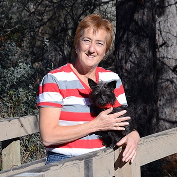
On Saturday, we went for a short hike close to their home. It was a nice spot, with several creeks coming together on their way to the American River. Although most of the leaves were gone, it was pleasant to be in the woods, especially after months in the Arizona desert. There was a little bridge across the creek and we took the opportunity to take photos of each other. Here’s Rod and Liz in one shot and me and Penny in the other.
On Saturday night, we were invited a burn party at a friend’s house. Let me explain. In this area, folks have lots of trees and brush. To get rid of this stuff, they burn it. They’re allowed to do this with a permit on certain days and under certain conditions. Unfortunately, our host discovered after inviting everyone that she wasn’t allowed to burn that day. But the party went on anyway, on the back patio of a wonderful little rental house she owns on the American River. There was a fireplace back there and we kept feeding it logs. Lots of food: shrimp cocktail, sausages, salads, dips, and chips. Our host was a part owner of a 100+ year old winery in either Napa or Sonoma valley (I can’t remember which) and served up the best cabernet and zinfandel (no, not the pink kind), making me feel a bit embarrassed about bringing along some of the white wine from Washington that my husband had left behind in our house. Later, when the fire was good and hot, we took turns roasting marshmallows. I was thrilled when our host offered me a bottle of her winery’s award-winning Zinfandel to take home. (I’m saving it to share it with someone special who will really appreciate it.)


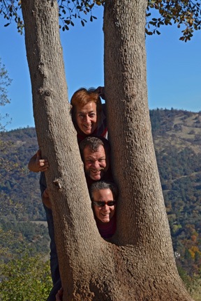
 On Sunday, Rod took us in his Volkswagen Thing for a more strenuous hike without the dogs. We started near the site of Sutter’s Mill — where the California Gold Rush began in 1849, in case you’re not familiar with this bit of history — and hiked up the trail in the Marshall Gold Discover State History Park. The trail was steep and Rod set a good, fast pace that had me huffing and puffing. Funny, but in my fat days, I never would have been able to keep up. On that day I worked up a good sweat but never really lagged behind. At the top of the mountain were some nice view points. We found a picnic area and stopped for a rest and a snack. That’s where I set up my camera and timer for a fun shot of our three heads between two tree boughs and a few more portraits.

 Afterward, we headed down to where Liz works, the Wakamatsu Tea and Silk Colony Farm. This interesting historic site is the location of the first Japanese settlement in the United States. It’s also where the first child to Japanese immigrants was born and the site of the first Japanese immigrant’s death. Today, the farm has trails, the gravesite, and other farm buildings more recent to the area. We walked among the black walnut trees, picking up and munching on walnuts that had fallen from the trees. I’d never had fresh walnuts before and really enjoyed the experience. We hiked past a big pond, followed by the farm dog who bugged Rod to throw sticks for him. We went as far as the gravesite before turning around and going back to the car. The moon had risen in the east and flocks of Canada Geese were flying.

We took it easy on Monday morning. I helped Liz clean up some debris from a tree removal job while Rod took his other Land Rover down to Placerville to get something checked on it. By the time he got back, I was packed up and ready to go. We made a leisurely trip down to Sacramento, stopping for lunch at the excellent Newcastle Produce for a sandwich and other treats. Liz bought a big bag of seedless mandarin oranges and gave me 8 of them to take home. (I shared three of them with my seat mates on the flight home.)
We said goodbye at the airport and I admit that I was very sad to go. It had been a great weekend with friends, doing lots of fun, new things.
My New Life: It’s All about Getting Out and Experiencing New Things
I feel, in a way, that I missed out on a lot of things over the past few years of my life.
Over the past few years, I was stuck in a rut with someone who either couldn’t or didn’t want to get out more. Although I felt that something wasn’t quite right during those years, I now realize that I felt sort of “trapped,” with most of my time spent either at the cavelike Phoenix condo or at our Wickenburg home. Day trips with my “life partner” were only possible on weekends, and even that was limited to places we had already been. He used all of his vacation time traveling back east to be with his family — people who never made me feel welcome or comfortable. More often than not, especially in the last year of our relationship, I felt as if my presence and desire to get out and do different things was an inconvenience to him.
He solved the problem for me, although the way he did it was neither kind nor honorable. That’s something his conscience needs to deal with — if he still has a conscience.
In the meantime, I’m making a special effort to get out more and do more things. The past three months have been among the most active in my entire life, with several trips out of state to visit friends as well as lots of day trips with new people.
But among all the things I’ve done recently, this Thanksgiving trip was the best. Many thanks for Rod and Liz for making me feel so welcome and keeping me busy!
 The folks at Lynda.com put authors up in an area hotel. The first few times I came out here, they put me in a Holiday Inn Express near Ventura Harbor. I really liked my room, which was on the first floor with big windows overlooking the marina. There was a lot of life there — people walking, birds flying, boats, dogs, joggers.
 Which brings me to the pelicans.
 In other words, I wasn’t properly equipped.


