Snowbirding 2018 Postcards: Camping at the Holtville Hot Spring LTVA

The Holtsville Hot Spring in Southern California is a BLM — that’s Bureau of Land Management — managed property just off of I-8 east of Holtville. The property features a maintained hot spring with two soaking tubs and a hot shower, a 14 day free camping area, and a long-term visitor area (LTVA) where camping is available for $40 for two weeks or $180 for the entire season.

I arrived here on Thursday with my friend Janet and we camped out for the night in the free 14 day area. We had a nice soak in the hot tub the following morning and then Janet departed for Yuma and Quartzsite. I stayed behind. I decided that I wanted to spend a few days in the area and I splurged for the $40, 2-week camping permit. I can use the remaining time next week at another LTVA in California or Arizona.

The main benefit to camping in the area north of the freeway is that it is easier to access the hot spring via a hard-packed dirt road that I can take my bicycle on. The sites are spread apart and because there are some trees in the area, there’s a certain level of privacy. The farther away you go from the hot spring and freeway, the quieter it is and the fewer campers are around you. I’m about half a mile away and can’t really hear the freeway at all.

The folks who stay in places like this are serious about off the grid camping. Just about every single rig out here is equipped with at least one solar panel. I have yet to hear a generator running. There are no power, water, or sewer hook ups or even a dumping station. The only luxury convenience is a set of dumpsters so you can get rid of your trash. I noticed more than a few folks filling up gallon sized jugs at the hot spring from a hose that’s provided just for that purpose; I’d like to think that they wash with this water and don’t actually drink it.

Almost all of my fellow campers are retirees and I estimate that at least half of them live on the road full-time. The types of campers range from slide in truck campers like mine to luxury Class A motorhomes pulling cargo trailers or cars. More than a few people have motorcycles or ATVs. People are friendly and often stop to chat while walking or biking by with their dogs.

I sent the Mavic up for picture of my campsite today. Here’s one that gives you a good idea of the area around me.

This photo faces south on an overcast, hazy day. Normally, you’d be able to see mountains in Mexico, which is only 6 or 7 miles away. If you’re wondering why I didn’t back all the way into the campsite, it’s because there are a lot of soft, sandy spots that I could get stuck in. Because I’m only staying here a few days and because I can use my bicycle to ride between my campsite and the hot spring, I didn’t bother taking the camper off the truck. I did, however, lower the legs to steady it so it wouldn’t rock so when I’m inside. The photo makes the place look kind of dreary but I think it’s today’s overcast skies more than anything else. The weather has been in the 70s every day, dropping to the 40s at night. This is the first overcast day I’ve had in over a week, but there’s still enough solar radiation to charge the camper’s batteries.

Aerial Photography: Helicopter vs. Drone

Picking the right tool for the job.

I’ve been thinking a lot lately about aerial photography work with helicopters and drones and thought I’d take a few moments to share my thoughts and conclusions. If you think one or the other is the perfect aerial photography platform, think again and read on.

My Helicopter Aerial Photo Experience

I’m a commercial helicopter pilot and have been one for about 17 years now. Of the modest 3,600 or so hours I’ve spent flying, a lot of it has been on aerial photography missions:

    Airplane over Horseshoe Bend
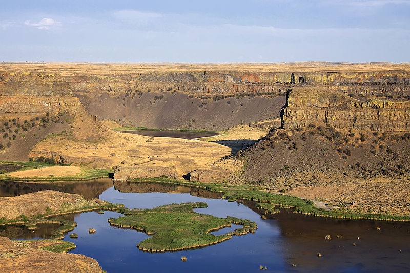
One of my favorite clients, Mike Reyfman, shot this photo of Horseshoe Bend near Lake Powell from about 3000 feet up. Note the tour plane, which was probably flying about 1,000 feet over the “shoe.”

  • Fine art photo flights over Horseshoe Bend, Lake Powell, Monument Valley, Canyonlands National Park, and the Four Corners area near Shiprock, New Mexico. (I’ve probably spent more hours with photographers over Lake Powell, mostly from 2006 to 2011, than any other commercial helicopter pilot. At one point, I could identify every point along the lake from an aerial photo.)
  • High speed desert racing photo flights at the Parker 425 in Parker, AZ.
  • High speed boat racing photo flights at Lake Havasu in Arizona.
  • Bike racing photo flights in the Lake Wenatchee and Leavenworth areas of Washington.
  • Automotive promotional photo flights over proving ground test tracks in Arizona.
  • Architectural and construction photo flights in major cities like Phoenix and Las Vegas as well as remote areas such as Burro Creek in Arizona.
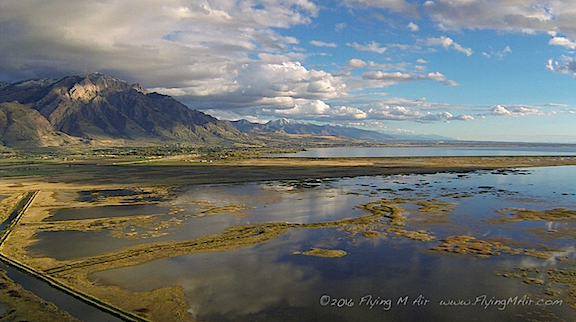
  • Geographical photo flights along the Wenatchee and Columbia Rivers, Lake Chelan, and Stehekin in Washington, Colorado River in Utah, and Salt River in Arizona.
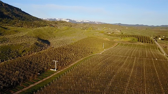
  • Agricultural photo flights in the Quincy, George, and Wenatchee Valley areas of Washington.
  • Wildlife photo flights over the Navajo Reservation and Verde River Valleys in Arizona.
  • Nighttime panoramic photo flights over a crowded football stadium at night in the flight path of Phoenix Sky Harbor airport.
  • 360° panorama photo flights over Lake Powell, Horseshoe Bend, Goosenecks, and Bryce Canyon National Park.
  • Air-to-Air photo shoots with everything from another helicopter to the world’s largest biplane to a 747 outfitted for firefighting.

Each mission had a different purpose, a different focus (pardon the pun). Each required a different kind of flying, from 4,000-foot (AGL) hovers to low-level, high-speed chases in obstacle-rich environments. Some required top speed level flying just to catch a target, others required tight, often difficult maneuvers in a choreographed dance with the target. In each case, my helicopter and I were the tools the photographer used to get the shots he needed. The photographer provided instructions and I positioned us where we needed to be.

Desert Racing Truck
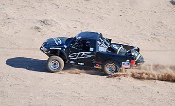
There’s nothing quite like chasing trucks through the desert with a helicopter.

I love aerial photo work, especially the challenging high-speed work I did over desert race courses. There’s nothing that can give me a buzz more than chasing a trophy truck down a twisty dirt track 80 feet off the ground at 80 miles per hour, so close I can hear his passing horn when he comes up on a competitor.

My Drone Aerial Photo Experience

As I’ve written elsewhere in this blog, I was not happy when I started losing aerial photo work to drones. I fought back for a while but, as technological improvements in both the flying and photo capabilities of drones made amazing results easier to achieve, I eventually got on board. I bought my first drone last winter and got my commercial drone pilot certificate soon afterward. (Yes, if you can’t beat them, join them.)

Here’s some footage from a recent practice flight around my home.

I don’t have nearly as much drone photo experience as I do helicopter photo experience, but I’m learning more every time I go out for a flight. I’ve been doing practice flights around my neighborhood, picking photo targets and flying around them for video fly-by shots and still images. I’ve also been taking my drone out to new locations to practice in target areas I find interesting. This winter, I’ll be using my drone to take photos of campsites out in the desert, as well as my activities on various Arizona lakes and rivers. Practice makes perfect and I’d like to get as good at drone photography as I am flying my helicopter on photo missions.

The Best Tool

I have, however, already come up against the limitations of drone photography, primarily related to speed, altitude, and operating temperature. I figured I’d list a few kinds of photo missions and explain which tool I’d pick and why.

Low-level, Low-Speed Operations

This is pretty much a no-brainer: when you’re operating below 200 feet at speeds of less than 20 miles per hour, a drone is probably going to be the better tool for the job. Yes, a helicopter can fly that low and that slow, but it’s far more likely to cause a disruption.

My best example of this is an aerial photo job I did for a local video production company. Believe it or not, they got the Wenatchee Symphony Orchestra to set up and play at dawn in a local park. The park had lots of tall evergreen trees and the orchestra was set up in a clearing. I had to get the videographer low enough for his closeups. The first time we passed, the helicopter’s downwash blew the sheet music off half the stands. (Oops!) A drone would have been a much better tool for this particular mission — and I actually said so during the flight.

Of course, blowing things around isn’t the only issue a low-flying helicopter can cause. It can also be a distraction to people on the ground. One of the flights I did for the same video company was a flight down Wenatchee Avenue not much higher than the highest buildings in the area. I had to fly sideways since the videographer was shooting out a side door. Although we got the job done, I think a drone could have done it better: it could have flown lower without distracting or disturbing drivers and pedestrians. The fight was short — we got the footage in less than 30 seconds — but a drone could have done the same thing without anyone on the ground even noticing it.

Better Choice: Drone

Low-Level, High Speed Operations

Of course, when you add speed, the drone simply can’t do the job. Consider my work chasing vehicles on land or over water. I’m usually flying at 50 miles per hour or more. (Seriously: on some of the boat shoots, I could not keep up; those things are fast.) I know that my drone’s top speed is about 22 miles per hour; even if a drone could go faster, could it keep up? I doubt it. And what happens when it gets out of range of the operator and his controller?

Better Choice: Helicopter

High Altitude Operations

While too many drone pilots seem to ignore drone altitude restrictions, they do exist and violating them is a good way to get into hot water with the FAA. Of course, trouble is a lot better than the possible alternative: flying into the path of another aircraft and causing a crash. As a helicopter pilot with no minimum altitude, I’m terrified that this might happen to me.

In the U.S., the FAA has established a maximum altitude for drones of 400 feet. Although it may be possible to get a waiver for a specific mission, it can take up to 90 days to get that waiver. How often do you know what you need to shoot 90 days in advance?

Helicopters, on the other hand, don’t have any altitude restrictions — other than those related to the helicopter’s performance capabilities. I’ve done photo flights where I had to hover at 9000 feet above sea level. Even if a drone could get up there, without a waiver it would not be legal.

Better choice: Helicopter

Operations Where Drones Aren’t Allowed

One of the things that really bugs me as a drone pilot is the number of places where drone operations are simply not allowed.

Some of them make sense — after all, do you really want to step up to the rim of the Grand Canyon and see a cluster of drones buzzing around in your view? Or attend an outdoor concert with drones flying back and forth over your head?

Meanwhile, drone restrictions in other places seem to make little or no sense. There are parts of Death Valley, for example, that are so remote they have few (if any) visitors and no wildlife. Why not let someone use a drone to take a few great photos that show off the barren wildness of the terrain?

Whatever.

The point is, there are places you can’t take a drone and, oddly enough, you can still take a helicopter. While flight over the Grand Canyon might be off-limits below 14,500 feet in most places, there are many national parks and other places where drone flights are prohibited but there are no restrictions on helicopter operations.

Let me be clear here: Most national parks are charted and pilots are requested to maintain at least 2,000 feet above the highest terrain in the area. Note the use of the word requested. I’ve written about this before. Although it is legal to fly lower in these areas, it’s not something you should do if you can avoid it. If you become a nuisance, you will be cited and will likely have to fight the FAA to keep your certificate. That’s why a lot of commercial pilots simply say no. Also, if people keep flying low-level through these areas, the FAA will make it illegal.

Until then — well, get those shots with a helicopter because without a waiver, you won’t get them legally with a drone.

Better Choice: Helicopter

As for flying low-level over crowds, that’s just plain stupid. Don’t do it with any aircraft, no matter what size it is.

Operation in Extreme Temperatures

All drones have operating temperature limitations, often due to battery capabilities. My drone, for example, will only operate in temperatures between 32°F and 104°F (0°C to 40°C).

My helicopter, however, doesn’t have any temperature limitations specified in the pilot operating handbook — although many people will argue that since performance charts aren’t available below -20°C or above 40°C, flight at those temperatures isn’t allowed. Newsflash: I’ve seen in-flight OAT temperatures of 112°F (45°C) in my helicopter and it still flew. I’ve also flown it when the outside temperature was about -10°F (-23°C) — the hardest part was getting it started; when it finally warmed up, it flew fine. (Unfortunately, it was a door-off photo flight; I don’t think I’ve ever been so cold in my life.)

The point is, if you need to do the shoot in very hot or very cold conditions, you might have to use a helicopter — or wait until conditions change.

Better choice: Helicopter

Operations Over Long Distances

I once had a photo shoot that included dozens of target locations along a 30-mile stretch of the Wenatchee River, a 50-mile stretch of the Columbia River, and the remote lakeside town of Stehekin on Lake Chelan. In my helicopter, we were able to knock off every location on the list in a total of three hours.

None of the flying was very special. It was relatively low and slow stuff, with some slow circling around points of interest. In fact, all of the shots could have been made with a drone. But that drone would have had to be driven to each location and launched for a flight there. It would have taken many hours to get all the shots and, if light was important — as it was for this shoot — the drone pilot/photographer probably wouldn’t have been able to shoot more than two to four locations each day. Add to that a half-day ferry ride to Stehekin, an overnight stay for the best light, and the half-day return trip and the project could have taken up to a month to complete.

Yeah, it would have been cheaper to do it with a drone. But time is money.

Better choice: Helicopter

Not Quite What I Expected

Part 107 Explained
Want to become a commercial drone pilot? Start by learning all about the FAA’s Part 107. This book will help. Buy the ebook edition on Amazon or from Apple. Or buy the paperback edition on Amazon.

In writing this and thinking about the kinds of aerial photo flying I’ve done, I’m surprised at how few photo missions are better handled by a drone than a helicopter. It seems to me that drone aerial photo flights are pretty much limited to situations where the camera needs to fly low and slow. Anything else would probably exceed the capabilities of the drone or violate the law. That might be where a helicopter can get the job done.

Fortunately for commercial drone pilots, there are plenty of missions that require low and slow flight. So there will never be a shortage of work for them.

But what makes me very happy is the knowledge that drones will never fully replace manned aircraft — including helicopters — for aerial photo missions. After all, that’s the kind of flying I really like to do.

Personal Aerial Photography

A few thoughts from someone who has been doing it for a long time.

I’ve been doing aerial photography since I began flying helicopters, way back in the late 1990s. At first, it was a few digital images shot awkwardly with my left hand while my right hand was busy on the cyclic. Later, I went through a variety of different cameras mounted in and on the helicopter, some set to automatically shoot whatever was in front of them and others with limited control from inside the cockpit. I had a POV.1 camera in 2008, which I replaced with a GoPro Hero in 2010. Since then, I’ve had a variety of GoPros, right up to a GoPro 3+. (Even I get tired of throwing money at new versions of hardware.) I’ve created numerous still and video images from my helicopter, some of which still amaze me.

Great Salt Lake
This is one of my very favorite aerial photos: the north end of the Great Salt Lake, shot with a GoPro 3 mounted on the nose of my helicopter as I flew it south to Arizona last autumn. The camera was set to time-lapse mode, shooting one photo every minute. We were probably about 700 feet up here.

But the point of this discussion is this: I’ve been looking at the world from a different point of view for about 20 years now. It’s not the same point of view as an airliner cruising at 29,000 feet and 500 mph. And it’s not the point of view of a private plane cruising at 1,500 feet and 140 mph. It’s the point of view of a helicopter, usually cruising at an average of only 500 feet at 90 miles per hour, with the ability to stop, make sudden turns, or descend for a closer look.

Pilots get used to seeing the world from this different perspective. After a while, it isn’t anything special. We can get a feel for how different things might look from the air: a canyon, a river, a farm, a junkyard. That doesn’t mean it gets boring — it doesn’t. But it does mean that we don’t see anything special about it anymore.

Kind of sad, isn’t it?

That’s one of the reasons I like flying with first time passengers. I get a reminder of what it’s like to see things from a new perspective.

Part 107 Explained
Want to become a commercial drone pilot? Start by learning all about the FAA’s Part 107. This book will help. Buy the ebook edition on Amazon or from Apple. Or buy the paperback edition on Amazon.

But I was reminded again about the novelty of seeing everyday things from above when I watched a documentary on Lynda.com called “Flight Club: Drones and the Dawn of Personal Aerial Imaging.” Listening to the people explain how they felt when they saw these low-level aerial images really helped me understand just how amazing aerial photography is, especially to folks that don’t have a helicopter at their disposal — which, admittedly, is most people.

Folks who know me well know how anti-drone I was when they first started appearing on the scene a few years back. But what convinced me that they were serious photography tools is the quality of the images they produced and the ease at which an operator could get them. I dove into drone photography last winter with the purchase of a Mavic Pro and will be doing a lot more of it in the months to come.

If you are curious about drones for aerial photography, I highly recommend you spend 25 minutes or so watching the documentary I saw last night. I think you’ll enjoy it and learn a lot about why people are so excited about it.

If you do watch, let me know what you think.

Killer Floods

A review with a backstory.

Last summer, I did a flying gig that started in Spokane and had me flying over a good portion of the state. The client was a video production company based in the U.K. that was working on a NOVA documentary about the ice age floods, which are often referred to as the Missoula Floods.

If you don’t know anything about the Missoula Floods, here’s the short version. Millions of years ago, when the Cascades were a chain of active volcanos, they laid down layer after layer of lava that became (mostly) basalt rock. The Ice Ages came and a sheet of ice stretched from the North Pole down into the northern United States. In Montana, the ice sheet formed a dam across the mouth of a valley and huge volumes of water accumulated behind it. Over time, the ice dam was eroded and broke free, releasing all that water very quickly. It came downstream, across Idaho and Washington State, carving out some very interesting canyons and other formations. Then the ice dam was created again and broke again and created again and broke again. This cycle happened at least 15 times, depending on who you talk to, starting about 16,000 years ago. It explains the modern geology of Central Washington state’s coulees (those carved canyons), potholes, dry waterfalls, and so-called Scablands. You can read more about this in Wikipedia. Or you can just watch the documentary I’m reviewing here.

The best way to get an idea of the massive scale of the hydrologic action resulting from the Floods is from the air. Sure, you can take a hike into a coulee or to the top of Dry Falls and look around, but it isn’t until you get a few hundred feet up that you realize just how enormous these places are. So the film crew looked for a helicopter with a Cineflex camera mount. Of course, there aren’t any of those outside a big city and they did have a budget so bringing one in was not an option. They did, however, find my helicopter company, Flying M Air, which, at the time, owned a Moitek gyrostabilized camera mount (which I’ve since sold).

I should mention here that this is the one and only time that damn camera mount got me a flying gig. I bought it to increase my aerial photo business and very seldom used it. I charged a fee for its use and it probably finally paid for itself sometime in 2014; I’d owned it since 2009. It was a beautiful piece of equipment, exquisitely hand made right here in Washington State, but it weighed a ton and took 30 minutes to assemble and another 20 minutes to break down. I hated dealing with it, despite the $500 per use fee I charged. Packed in two huge Pelican cases — one for the mount itself and one for the three Kenyon KS-8 gyros that went with it — it took up space and gathered dust on my garage floor. I sold it to an LA-based pilot for just $5K this past summer. What a steal. The gyros alone were worth more than that — but I don’t miss it one damn bit. It was not one of my best asset acquisition decisions.

The Flights

Turns out that they needed a videographer who could use the mount and had appropriate equipment to mount on it. I turned to Charley Voorhis of Voortex Productions, one of the two local video companies I’ve worked with. Charley has some impressive equipment — I think he brought one of his RED cameras for this gig — and lots of experience with the mount. (I almost wish he’d bought it.) Then I stepped back and let him make his deal with the client. All I cared about was flying.

The day of the flight came and we left, bright and early, for Spokane. I’d already set up the mount as far as I could, tying it down with gaffer tape since it would be out of balance until a camera was on it. I’d put the door back on so we could maximize cruise speed to get to the client meeting site; the helicopter is limited to 100 knots with any door off. We got there on time and met at the FBO to come up with a plan. I had them top off the tanks with fuel and removed the door where the camera mount was. Charley set up his camera.

We wound up doing several flights. The first was a long one that started in Spokane, flew directly out to Dry Falls — which is about 2/3 of the way back to Wenatchee — circled that more times than I can count, and then headed down the smaller lakes to Ephrata, past Moses Lake, and over the Potholes Reservoir. On board were me (of course), Charley, and the video director (or producer?) who told Charley what shots to get. The mount took up a whole seat but I wouldn’t have taken a third passenger if I could; I have a strict policy regarding the number of people on board for photo flights and always limit it to three.

Dry Falls Photo Shoot
Here’s a closeup of my track, recorded automatically by ForeFlight, for the time we were in the Dry Falls area. What’s ironic here is that we flew around in a noisy helicopter for a good 15 minutes and likely bugged the hell out of people on the ground. A drone probably could have gotten the same footage without disturbing so many people. (Of course, it would have taken most of the day.) But because Dry Falls is a Washington State Park, drones are prohibited. Go figure, huh?

Dry Falls
Photo of Dry Falls by © Steven Pavlov / http://commons.wikimedia.org/wiki/User:Senapa, CC BY-SA 3.0, https://commons.wikimedia.org/w/index.php?curid=16059590 I think that most of the footage shot from my helicopter and used in the documentary was shot in this area.

After refueling at Moses Lake — we’d flown about 2-1/2 hours since leaving Spokane — we pretty much high-tailed it back to Spokane. Then we did two flights south past Cheney and east of Ritzville. That’s where the Drumheller Channels are. I’d never even heard of the place, but apparently it’s one of the best examples of the Channeled Scablands. One flight was with the same group on board; the other was with the geologist you see in the documentary. When the geologist was on board, the client’s own videographer flew with me, sitting beside me to shoot the geologist in the seat behind me as he spoke about what we were flying over. That’s probably also when they got footage of my helicopter’s panel and even me. Those two flights each took about a 1-1/2 hours with refueling in Spokane between each one.

After that, we were done. I dropped everyone off in Spokane, retrieved the door, and put it back on. Charley and I sped back to Wenatchee where we went our separate ways.

I think the whole gig was supposed to be just 5 hours, including travel time, but I flew (and billed for) more than 9. It was a very lucrative gig. But what was [almost] better was how much I saw and learned about the geology of the state. That’s one of the reasons I like doing aerial photo work; I get to see and learn a lot.

The Documentary

I have to admit that once my invoice was paid — which took a little effort since the money was coming from the UK — I didn’t give the project much thought. I didn’t even blog about it. That’s probably because last summer was very busy for me and I did a lot of cherry drying work. I even dried cherries later that day. I’d stopped blogging about my interesting flights, although I really don’t know why.

So imagine my surprise when a lawyer friend asked me yesterday in an email if he’d just seen my helicopter in a NOVA episode.

I went online and found the NOVA episode titled Killer Floods immediately. And although I rarely watch television during the day, I’m recovering from a cold and figured it was a good way to kill an hour. So I sat down, fired up the Roku with PBS, and watched it.

Let me start by saying I generally like NOVA documentaries. At least I used to. They’re filled with facts and good videography and leave you feeling better educated about topics than you were before you watched them. But I don’t know if it’s a general trend in documentary filmmaking or just a new NOVA style, but it seems to me that they’re trying too hard to sensationalize the topic or apply it to today’s world.

Two things immediately struck me about this one.

First, the name: Killer Floods. This particular documentary covered three flood events, all three of them were prehistoric. So although it’s likely that they killed something — plants? animals? — they didn’t have an impact on man at the time. In addition, their significance was not the fact that things were killed but more that the flooding changed the shape of the landscape by suddenly and violently eroding and washing away rock.

Second, the attempt to suggest that the three floods documented in the video have anything whatsoever to do with today’s flooding due to climate change. They managed to include footage from the flooding in Houston from Hurricane Harvey — a mere two months before air time! — which has absolutely nothing to do with these three prehistoric floods. Yet the narrator suggested that they might be related. I think that’s stretching it beyond reasonability.

But hey — I get it. They want people to watch so they come up with sensationalized names (see also Killer Hurricanes and Killer Volcanoes), and try to get people interested by pointing to recent events that they’re familiar with. After all, is the average person going to be interested in a documentary about how three prehistoric flood events changed the landscape in relatively remote areas of Central Washington State and Iceland or under the English Channel? I doubt it. NOVA is competing with reality TV, sitcoms, and sports. While I’m interested in just about any topic NOVA covers, most people aren’t. Sad but true.

That said, I thought the documentary was well written and produced, with plenty of good videography, interview clips, and narration. It walked viewers through the logical process of figuring out how each of the three landscape formations they were researching were actually made. (I already explained the one in Washington State; I’ll let you watch the documentary to learn about the other two.) The Washington one was a bit slow for me because I already knew the answer but I found the other two fascinating. I’ve been planning a trip to Iceland for late next summer and may extend it a few days to take in some of the sights shown in the documentary. And now I have a fresh desire to see the White Cliffs of Dover.

But what really tickled me was seeing my helicopter near the very beginning of the documentary, with the Flying M Air logo prominently displayed. Later, a shot shows my door with my name on it. And somewhere else near the beginning, you can see the helicopter’s controls and even a quick shot of me looking like a bit of a bum in my gray sweatshirt.

Those glimpses were enough to get my brother, who never picks up the phone, to give me a call yesterday evening. “I’m watching NOVA. Is that your helicopter?”

And that set off an hour-long conversation about all kinds of things. Heck, I talked more with him yesterday evening than I had all of last year. (Seriously: he just doesn’t like to talk on the phone.)

This obviously isn’t the first time I’ve been involved in a video production. I’ve been flying this helicopter since 2005 and have done countless video/photo shoots over the past 13 years. But I’m pretty sure this is the first one that has appeared on PBS or a highly respected documentary series like NOVA.

It’s about as “big time” as my little company will get — and that’s okay with me.

If you’re going to watch it, watch it soon. The website says it “expires” on December 7. If you’re really interested in flood-related geology, why not get the video? You can buy it on iTunes.

Look for me in the credits.

More about the Wind Machines

A few new videos.

Back in April 2015, I blogged about the wind machines commonly used for frost control in the Wenatchee Valley. Resembling tall fans, different versions of these machines can be found in agricultural areas throughout the west wherever frost — especially early spring frost — is an issue. Around here, they’re often in low areas subject to thermal inversions.

Wind Machine
The wind machines that were running this morning. That’s the Mission Ridge Ski resort in the background. Photo shot with my Mavic Pro.

The machines are fans that generate wind. The blades spin fast — faster than you might think watching the video below — to circulate the air. The fan heads rotate to constantly change the direction of the wind. The net result is that the air is circulated, bringing warm air from above down into the crops.

In the almond orchards of California, they use helicopters to do this. I think it’s because the orchards are so big that they simply can’t install and maintain as many wind machines as they need. The helicopters are likely a lot cheaper in the long run, especially when you have a few years in a row when they’re not needed. I’ve been on frost control contracts for the past five winters now and have yet to turn a rotor blade over an almond tree. (Global climate change?)

This winter was particularly long, setting the tree fruit back two to four weeks. The cherry trees are still blooming around here; last year, the cherries were already beginning to redden in the orchards closest to my home. Nighttime temperatures at my home have been in the low 40s. But in the orchards below me, pockets of colder air form. And this morning, they got cold enough to trigger the temperature-set auto start feature on the wind machines in the closest orchards.

I don’t know exactly when they started. I was up at 4:30, reading before getting out of bed, and I didn’t hear them. But by the time I made my coffee at 5 AM, I could hear them faintly through the walls and windows of my my home. I stepped out on the deck for a better look in the predawn light. The sound was louder and I could see two of the machines to the west spinning. My ears told me that one to the northeast, which I can only see from a handful of spots on my deck, was also spinning.

Here’s the zoomed in video I shot with my phone. When I shut up, you can hear the wind machines.

I did a Periscope — that’s a live Twitter video — of the wind machines. A handful of people tuned in and I answered questions as they came up. I was frustrated that I couldn’t zoom in. I signed off, used the video feature on my phone to capture a short zoomed-in clip, and posted it on Twitter. Then the sun rose and the light got good and I did another Periscope that was mostly to show off how beautiful the area was. The wind machines droned in the background of my voice as I described various things and answered questions.

I went inside, washed some pots from cheesemaking, and listened to the radio. I could hear the wind machines faintly through the walls and windows. I was sort of bummed out that I couldn’t give people a better view.

Part 107 Explained
Want to become a commercial drone pilot? Start by learning all about the FAA’s Part 107. This book will help. Buy the ebook edition on Amazon or from Apple. Or buy the paperback edition on Amazon.

And then I remembered my Mavic Pro.

It took only two or three minutes to set it up. I launched it from my deck, got the video camera going, and sent it to the wind machines, stopping before it got so close that the wind could affect it. The light was beautiful and the image the Mavic sent back to me was clear. I hovered for a while to capture a good clip and then flew around a little, just taking in the view with the camera running. I stopped the video camera, took some stills, and then flew home for some more video of my home and the area around it.

Back inside, I made a fresh cup of coffee and spent a few minutes editing the video and setting it to music. It’s unfortunate that the Mavic doesn’t capture sound, but I understand why: it would be capturing its own buzzing sound, which isn’t pleasant. So music will have to do.

A side note here: I’ve been thinking a lot lately about how much I like living here. I realized — and I think I mentioned in one of those Periscope videos — that I like it here more than anywhere else I’ve lived. I’m not sure if it’s because of the place itself or the fact that I have a home with an amazing view built to exactly meet my needs or because after a stifling relationship that went on a lot longer than it should have I finally have the freedom to do what I want to do with my life and time.

Whatever the reason, I just want to remind readers that we all have just one life and it will eventually end. Don’t waste it stuck in a rut or in a place you’re not happy.