Aerial Photos from Quartzsite

Just a few shots taken by a French photographer.

Back in January, I wrote a blog post called “Over Quartzsite.” In it, I told the story of a photo shoot over Quartzsite, AZ.

The post was remarkable in that it got a comment from someone who had heard about my overflight from one of the folks on the ground that day. It’s always rewarding when I write about one of my experiences and someone who was there from a different point of view comments on it.

Anyway, I didn’t hear anything from the photographer after the flight. Until today. He e-mailed me:

My story about QZ was published last week in France, six pages in a weekly.

I attached few of the aerial shots. Photos 1 & 2 were published.

For your private record you can post it but don’t give them away.

Also, I did again overnight park my camper outside a motel.
On Superbowl Sunday, I drove to Blythe and book a room to watch the game.

Good flights in your lovely state.

Attached to the message were five images that he took that day.

I asked his permission to reproduce low-res versions of the images here. He graciously said yes. If you read French, you can find his article at http://www.vsd.fr/contenu-editorial/photo-story/l-oeil-de-vsd/
58-arizona-les-papys-font-de-la-transhumance
. All of the aerial photos were taken from my helicopter.

Here are the three I like best.

Quartzsite FisheyeThis photo shows a super wide angle view of Quartzsite from the south, right around sunset. No, we weren’t high enough to see the curvature of the earth — that’s the effect of the photographer’s wide-angle lens. (Apparently, I’m not the only one who likes fisheye lenses.) In the foreground is the big tent for the RV show. This is the biggest week in Quartzsite. This, by the way, is what he refers to as Photo 2. I think it’s the best of the bunch.

Quartzsite from the Air
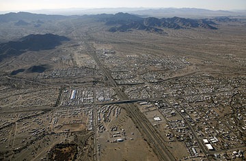
This shot was taken from the east side of town looking west, not long before sunset. The main road you see is I-10; it’s in the other shot, too. All those white specks are RVs — people dry camping out in the desert on BLM land.

Circle the Wagons!I love this shot. It shows a typical area of RV campers. Makes you think of old westerns, doesn’t it? Circle the wagons, boys! We must have spent 20 minutes circling this huge parking lot — I think he took dozens of photos. I think I like this shot because it makes you feel as if the same pattern of circled RVs exists infinitely in this area.

Chasing Race Cars Isn’t for Every Pilot

Analysis of an accident report.

The other day, I got a call from an off-road racing team manager. He was interested in hiring me to chase his truck at an upcoming race. But rather than ask me the usual bunch of questions about rates and ferry times, he grilled me about my flight experience.

How long have you been flying? Do you own the helicopter? How many times have you done this?

I answered all of his questions honestly — I have nothing to hide. I’ve been actively flying for about 8 years, since I bought my first helicopter. I have about 1800 hours of flight time. I own the helicopter I fly and I’ve put all of its 610 hours on it. I’ve followed cars and trucks and boats during races about ten times now.

Then he asked, “Did you hear about the helicopter crash at Lucerne Valley last year?”

I told him I hadn’t.

“One of our guys was on board. The pilot didn’t have very much experience, so we’re careful about who we hire now.”

The Accident Report

Later, after discussing rates and finishing up the call, I looked up the info on the accident he referred to in the NTSB database. I found it under NTSB Accident number LAX05FA189. He’d been wrong about the accident date — nearly three years had passed since the May 28, 2005 accident in Lucerne Valley, CA. The helicopter had been a Robinson R44. Although no one had died, three people had been seriously injured in the crash.

I read accident reports to find out how accidents occur. This helps me stay aware of potential problems with my aircraft or flight situations. Here’s the short text of this particular accident’s description:

The helicopter impacted level terrain and rolled onto its left side while maneuvering during a low-level photo flight. The pilot was flying southbound along a racecourse on a photo flight when he made a hard 180-degree turn, and lost control of the helicopter. As the helicopter began a spin to the right, the pilot noted a loss of rpm and altitude. He asked the certified flight instructor (CFI)/safety pilot to take the flight controls. As the CFI took control of the helicopter, he realized that the rpm’s were decaying and that the helicopter was too low to recover the rpm. He attempted to cushion the impact with the collective. Both pilots reported that there were no preimpact mechanical anomalies with the airframe or engine. No evidence of any preimpact mechanical malfunction was found during the post accident investigation that would have precluded normal operation. During the accident flight, the helicopter was running approximately 131 pounds over the maximum gross weight for an Out of Ground Effect hover for the existing atmospheric conditions. The helicopter was being operated in a high density altitude environment, which was computed to be 7,350 feet mean sea level. The pilot received his rotorcraft helicopter rating 7 days prior to the accident. He had approximately 77 hours of total rotorcraft flight time at the time of the accident. The helicopter manufacturer indicated that photo flights were a high risk phase of flight and issued a safety notice SN-34. Safety Notice SN-34 recommended at least 500 hours and extensive training in both low rpm and settling-with-power recovery techniques prior to flying photo shoot type flights.

The National Transportation Safety Board determines the probable cause(s) of this accident as follows:
the pilot’s failure to maintain adequate main rotor rpm and directional control while maneuvering at low altitude. Contributing factors in the accident were the helicopter’s gross weight in excess of the maximum hover out of ground effect limit, a high density altitude, and the pilot’s lack of overall experience with regard to low rpm and settling-with-power recovery techniques.

Full narrative available

There’s a lot of information here. I’ll review it and explain the parts that might not make sense to folks who aren’t pilots, aren’t helicopter pilots, or are new helicopter pilots.

Out of Ground Effect Hover

Let me start out by explaining that helicopters need more power to hover than to perform just about any other maneuver. That might seem counter intuitive, since when you’re hovering, you’re really not going anywhere. But the reason for this is that when a helicopter is in motion, there’s an increase in lift from the relative wind against the rotor blades.

Effective Translational LiftFrom the FAA’s Rotorcraft Flying Handbook:

Translational lift is present with any horizontal flow of air across the rotor. This increased flow is most noticeable when the airspeed reaches approximately 16 to 24 knots. As the helicopter accelerates through this speed, the rotor moves out of its vortices and is in relatively undisturbed air. The airflow is also now more horizontal, which reduces induced flow and drag with a corresponding increase in angle of attack and lift. The additional lift available at this speed is referred to as “effective translational lift” (ETL).

So you use less power to fly than to hover. And any speed lower than ETL will require more power than speeds above ETL. Helicopter pilots often use 30 knots airspeed as a rule of thumb.

You can break down hovering into two types: in ground effect (IGE) and out of ground effect (OGE). From the Rotorcraft Flying Handbook:

When hovering near the ground, a phenomenon known as ground effect takes place. [Figure 3-7] This effect usually occurs less than one rotor diameter above the surface. As the induced airflow through the rotor disc is reduced by the surface friction, the lift vector increases. This allows a lower rotor blade angle for the same amount of lift, which reduces induced drag. Ground effect also restricts the generation of blade tip vortices due to the downward and outward airflow making a larger portion of the blade produce lift. When the helicopter gains altitude vertically, with no forward airspeed, induced airflow is no longer restricted, and the blade tip vortices increase with the decrease in outward airflow. As a result, drag increases which means a higher pitch angle, and more power is needed to move the air down through the rotor.

Here’s the diagram that goes with this information:

Hovering

Out of Ground Effect Hover R44Operating Handbooks for helicopters provide charts that help pilots determine the expected performance of the aircraft in a variety of conditions. The accident report indirectly refers to the OGE Hover Ceiling chart. This chart tells a pilot the maximum altitude you can expect to maintain an out-of-ground effect hover given the aircraft weight, altitude, and outside air temperature. The one shown here is for a Robinson Raven I helicopter (I can’t seem to find my office copy of my Raven II manual). Here’s how it works. Start by following the weight line up to where it hits the temperature line. Then follow that intersection across to the altitude.

For example, if the aircraft was 2300 pounds and the outside temperature was 20°C, the maximum OGE hover would be 3,000 feet pressure altitude. In this accident, the aircraft was roughly 2,220 pounds at the time of the accident and the temperature was about 31°C. Following those lines on the chart indicates that the maximum OGE hover would be 3,100 feet pressure altitude.

The accident location was at 4,266 feet MSL. So the pilot was operating in an area and at a weight that made out of ground effect hover impossible in his aircraft.

Now I don’t want people reading this to think that you can’t (or shouldn’t) fly a helicopter in a place where you can’t hover out of ground effect. That’s not true. But the OGE hover situation does weigh heavily into this accident because of the maneuvers required for the mission.

Lower Rotor RPM

Having just flown with a photographer for an off-road race, the kinds of maneuvers needed are very fresh in my mind. More than once, we were required to slow down to wait for a vehicle. We also hovered OGE several times, with and without slight tailwinds or crosswinds. And, of course, we often had to make sudden course changes that required sharp 180° turns. These are not simple maneuvers, especially when power is an issue.

I can also say from experience that when flying an R44, if you pull more power than what is available, the first indication of a problem will be a low rotor RPM horn. I’ve had this happen twice on takeoffs at high altitude locations (over 6500 feet) with four people on board. If you can increase airspeed to reduce the amount of power needed to fly, you can get out of the situation, but that normally means a descent. (In one case, I did a running take-off from an airport and was fine once airborne; in the other case, my takeoff was from the edge of a cliff, so a descent wasn’t a problem.)

Here’s how I see this accident setting up. The pilot is going very slowly, below ETL, almost in a hover, and makes a hard turn. The aircraft starts to settle, so he pulls more pitch. This increases the drag on the main rotor blades, but there isn’t enough power to overcome it. The blades slow down. The low rotor RPM warning system sounds its horn. He’s too close to the ground to push the cyclic forward and get the airspeed he needs to get out of the bad situation.

How could this have been prevented? One way is to lighten the load. The maximum gross weight for a Robinson Raven I is 2,400 pounds. The pilot and passengers weighed 230, 180, and 175 respectively. If the pilot had checked the OGE charts, he would have seen that the aircraft was too heavy to fly at speeds less than 30 or so knots. He could have taken on less fuel or, better yet, flown without the 180-pound man beside him.

Another way to prevent the problem is to keep the aircraft speed up, above a minimum of 30 knots. This will prevent the pilot from getting into a situation where OGE hover power is required.

I should note here that I considered buying a friend of mine’s R44 Raven I — until I looked at the OGE hover chart. The performance was simply not acceptable to me. I often fly to the Grand Canyon (6300 feet), our vacation property (6700 feet), and Sedona (5200 feet) on hot days. Based on the chart, it was uncertain whether I’d be able to land and take off from these destinations when the aircraft was near maximum gross weight. I needed the additional power and performance of the Raven II for flexibility and safe operation in these areas.

Pilot Experience

Like my potential client, I think a main contributing factor to this accident was the pilot’s inexperience. He had only 70 hours in helicopters, and this was the first time he’d flown this kind of helicopter at a race event. He simply was not prepared for the kind of maneuvers he’d have to perform to get the job done. Add that to the OGE hover problem and it’s easy to see how this could have happened.

Robinson Helicopter Company knows that inexperienced pilots should not be flying photo missions. It issued Safety Notice SN-34 in March 1999 which states:

There is a misconception that photo flights can be flown safely by low time pilots. Not true. There have been numerous fatal accidents during photo flights, including several involving R22 helicopters.

Often, to please the photographer, an inexperienced pilot will slow the helicopter to less than 30 KIAS [knots indicated airspeed] and then attempt to maneuver for the best picture angle. While maneuvering, the pilot may lose track of airspeed and wind conditions. The helicopter can rapidly lose translational lift and begin to settle. An inexperienced pilot may raise the collective to stop the descent. This can reduce RPM thereby reducing power available and causing an even greater descent rate and further loss of RPM….

The Safety Notice goes on to recommend that the pilot have at least 500 hours pilot-in-command time in helicopters and over 100 hours in the model flown before conducting photo flights.

Conclusion

I’m glad my potential client mentioned this accident and I’m very glad I looked it up. I learned a lot from reading it, analyzing it, and summarizing my thoughts here.

It’s also made me more aware of weight and performance at events like these.

When you do a lot of point-to-point flying, you become somewhat complacent about the aircraft and don’t consider the additional demands of multi-maneuver flying. Although I’m always concerned with the weight of my aircraft on takeoff, I tend to look at it more in terms of whether I’m too heavy to fly legally — over maximum gross weight. With only 3 people on board, unless we’re all fatties, that’s not usually a concern.

Parker was at less than 500 MSL and it was a cool day, so I admit I didn’t check the hover charts. (When you check them over and over, you get a “feel” for them and can “guesstimate” what they’ll say.) But after reading this and thinking about it, I’ll review the charts before each photo flight, even if I’m already pretty sure that OGE operations won’t be a problem.

Any thoughts, comments, experiences you want to share? Use the Comments link or form for this post.

Chasing Desert Racers

At the Best in the Desert/BlueWater Parker 425.

I spent this past Saturday doing one of the things I really love to do: chasing racecars with a helicopter.

The venue was the Best in the Desert Racing Association’s BlueWater Resort & Casino Parker 425, which featured highly modified trucks, cars, and buggies racing on a 140+ mile dirt track through the desert. My client was a television producer who videos these events from multiple cameras and turns them in TV shows. For this event, they had a total of 15 cameras, includibut thingsng one in my helicopter and several in the trucks out on the course.

I flew the helicopter with the cameraman and my husband, Mike, working as a spotter, on board. The cameraman sat behind me with his door off. Mike sat beside me.

We started before dawn at the Parker Airport. I started up at 7 sharp and was warmed up and ready to fly by 7:15. The police escort was leading the 300+ participant vehicles to the starting line on Route 95 in downtown Parker when we began circling about 500 feet overhead. The cameraman had a list of 15 targets he needed to video. The first one was the 15th truck in line at the start. Racers were released 30 seconds apart. When our first target was released, the fun began.

Desert Racing Truck
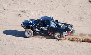
I chased the car down the paved road and onto the dirt track, descending as I left the downtown area. Soon, we were racing beside it just 70 feet up on the long straightaway that heads due east. Mike kept an eye out for wires, calling them out as he saw them. My attention was split between the truck, the wires, and the track in front of me. I worked the cyclic and collective hard, climbing, descending, slowing, speeding up. Both arms and legs worked automatically to make the helicopter do what I needed it to do. Spectators below me went by in a blur. The track made a 90 degree turn to the left and I paused at the inside of the curve just long enough to pivot so the cameraman could keep the camera on the target. Then down the short straightaway to the edge of a steep drop with high wires on one side. The truck descended the hill while I climbed over the wires. I met the truck on the other side and we raced together through a tree-filled dry wash.

“Okay, peel off,” the cameraman instructed.

I turned away from the target and followed the road back. Now we had to find the next target. All we had were numbers — we didn’t know much about how the vehicle looked, other than what class it was in. I had to fly low enough to see them. The first one of us to see a number, called it out. We got the next target halfway back to town. I lowered the collective to slow down and made a sharp 180 degree turn. Then I was on that truck, following it to the wires and into the wash.

We repeated this process about seven or eight times, each time picking up our target a little farther away on the track and ending a little farther down the track. I got to know exactly where all the wires were. Sometimes, I’d look down in time to see a spectator wave up at us or snap a photo. I think there were more photos taken of us that day than of any one racer.

This went on for over an hour.

Then, suddenly we could no longer find any of the targets we needed to video. That started a search up and down the track, flying low enough to read the numbers. Every once in a while, the cameraman would pick out a “trophy truck” or a vehicle driven by someone well-known, and ask me to follow it. I’d follow as closely as I dared, putting the cameraman close to the action. Inside the helicopter, through our noise-reduced headsets, we could sometimes hear the engines of the racers below us or the sirens of the vehicles preparing to pass. We watched one driver slip off the track and race along beside it, scattering spectators who had been standing too close. We shot some video of a modified Hummer flying through the air after a particularly bad bump.

I suppose I should mention here that I wasn’t the only helicopter at the event. There were at least five others: 2 R44s, an Astar, a Eurocopter, and a Bell Jet Ranger. In most cases, they’d been hired to follow a specific race vehicle or team. Once they left the area, they didn’t come back for a while. So keeping an eye out for aircraft wasn’t a serious issue.

After two hours, we headed back to the airport. I shut down and placed a fuel order. Then we drove over to the BlueWater Casino for breakfast. The cameraman the cameraman met with some of the folks he works with to see how many vehicles on his list were still in the race. Each vehicle had a transponder and satellite communications device so it could be tracked from headquarters at the Casino. According to the cameraman, fewer than 50% of the vehicles finish the race. Most of them break. And if you saw the track, you’d understand why.

With an updated list, we headed out again just before noon. We were expecting one of the target vehicles in the pit area, so we stayed nearby. There was a “serpentine” area just east of the airport, with winding, bumpy tracks in a big field surrounded by spectators. I think there was about 5 miles of road there, and it was so twisty that even from the air, I had trouble figuring out the route. We spent about 15 minutes there, filming the action of vehicles skidding around the sandy curves, throwing dust high up into the air. At some point, I realized that I was probably putting on a better show for the spectators than the cars and trucks were.

We spotted a target vehicle as he was leaving the pits and took off after him. More chasing at low level, avoiding wires, slowing when the truck slowed, speeding up when it speeded up. We peeled off and continued down the track, looking for more targets. That’s when we started seeing the breakdowns. Trucks and cars and buggies on the side of the road with parts peeled off of them and drivers bent over their innards. One team was changing a tire. Another was taking the hood off the car. We saw a fender alongside the track. Later, we saw a prone driver with his companion performing CPR. (The rumor I heard was the driver suffered a heart attack or stroke while driving and died on the race course. I have not been able to confirm this yet.)

Desperate to find one last vehicle on the cameraman’s list and looking for exciting footage, we followed the entire 140-mile course. It stretched from Parker through the empty desert as far east as Cunningham Pass (north of Wenden) and around Planet Peak (near the Bill Williams River) to the northwest. This much-reduced map gives you an idea of the distance — I’ve highlighted the track in light red so it’s easier to see.

Parker 425 Map

Much of the course was pretty boring from my point of view — lots of long, straight stretches. In one area, the road ran alongside a set of high tension power lines, making it tough to get low enough to see car numbers. But things got interesting on the last 4 or so miles, when the track headed into the mountains south of the Bill Williams River. The cameraman got some excellent footage of a car winding its way down a narrow canyon. I had to stay high — there wasn’t enough room for me to fly alongside it. But when the canyon opened, I dropped down so he could get some close-up shots.

After trying a few more times to find the missing buggy — we were in touch by radio with the satellite tracking people — we headed back to the airport and I shut down.

We’d flown a total of 5.0 hours. The sky had clouded up and lighting wasn’t as good as it had been earlier in the day. Although we’d planned a third flight for the finishers, the cameraman. The cameraman decided to skip it.

It had been a great day. Not only did I do a lot of flying, but it was the kind of flying I really love to do — challenging, exciting, and with a goal other than going from point A to point B.

Why can’t all my gigs be like this one?

Note: If you were at the 2008 Parker 425 in February and have photos or video footage of a plain red helicopter (no stripe) flying with the cars, please let me know. I’d love to show them off with this post or elsewhere on this site.

February 7, 2008 Update: I added a photo Mike took during the flight to give a better idea of what was going on at Parker.

Over Quartzsite

An interesting photo gig.

I got the call about a month ago. From France. A photographer with a name I couldn’t easily pronounce wanted to photograph Quartzsite, AZ from the air during its busiest time of year. This year, that’s January 19 through 27.

About Quartzsite

Quartzsite, in case you’re not familiar with the place, is a small desert community about 20 miles east of the Colorado River, right on Interstate-10. During the summer, it’s a glorified truck stop, with gas stations, a handful of fast food joints, and a few of the necessities of everyday life for the 1,000 or so people who live there year-round. But in the winter, it’s home to numerous events, including gem and mineral shows, a huge RV show, and flea markets. That’s when the snowbirds flock to the place, filling in the otherwise empty campgrounds and spilling over to the millions of acres of BLM land around the town. The population swells to an estimated 100,000 people, most of whom are living in extravagant RVs and motorhomes.

From the air, this is simply amazing. Quartzsite is nestled in a valley between two small mountain ranges. I-10 cuts through it east/west while route 95 between Parker and Yuma cuts through it north/south. The town is a concentrated sea of white rooftops. Scattered all around, in every direction, grouped in the BLM-approved camping areas, are more white rooftops, sometimes arranged in circles or rows.

Sadly, I don’t have a single photo of the place that shows it off.

Back to France

I gave the Frenchman a quote. He’d have to pay for me to fly to Quartzsite, fly around there for his photos, and fly back. We estimated that at about 3 hours: 1 hour ferry, 1 hour photo shoot, and then 1 hour ferry. At $495/hour, which is my current going rate, it wasn’t going to be cheap. He didn’t book, but that didn’t surprise me. About 90% of the calls I get are from folks who are “fishing.”

Two weeks went by. I got CCed on a message to a Frenchman from Robinson Helicopter, Inc. They told him that the closest Robinson helicopter operator to Quartzsite was Flying M Air. In other words, me.

Another week went by. I got an e-mail message from the Frenchman. He wanted to know about dates and weather. I told him that the weather in Arizona this time of year is usually perfect. He tentatively scheduled a flight for January 25. But since he wouldn’t provide a credit card number, I wouldn’t guarantee it. If someone else put up a card for the same date and time, he’d be out of luck.

The Gig Happens — Suddenly

On Saturday morning, I got a call from Etienne. He was in Arizona. He wanted to do the flight that afternoon because the weather forecast for midweek wasn’t very good. Was I available?

Oddly enough, Mike and I had planned to go camping in Quartzsite that weekend but had decided, just the night before, to skip the overnight trip and just drive out there for the day on Sunday. So I was available after another flight booked for 10 AM.

Etienne picked up an RV from a rental place in Mesa, AZ and drove it up to Wickenburg. He parked it in the airport parking lot. We had a pow-wow to go over details on timing. Then he went into town to book a hotel room — don’t ask me why; I don’t understand either. At 3:15 PM, he was back.

We took off to the west with coats on and his door off.

Fuel Concerns

I’d filled the helicopter’s fuel tanks to capacity. That’s close to 50 gallons of fuel. At my normal rate of consumption, that would last close to three hours. Unfortunately, we were expecting to be out for a full three hours. There’s no fuel between Wickenburg and Quartzsite. The closest fuel is Blythe, which is 20 minutes farther west. If we went there for fuel, it would add 40 minutes to his flight time. It would also have us crossing through very dark desert — and over several mountain ranges — long after sunset.

So I filled an approved fuel container with another 5+ gallons of fuel and tucked it into the back passenger area. There were two paved runways between Wickenburg and Quartzsite, as well as numerous other landing zones. If fuel got low on the way back, we could land, shut down, add 5 gallons, start up, and get back. Of course, if we spent a lot more time in Quartzsite than we expected to, we’d have to detour to Blythe anyway. Five gallons was only about 15-20 minutes of fuel.

The Gig

The flight out to Quartzsite was as boring as I remembered it. Etienne had asked me to show him Arizona. I warned him that the ferry flight didn’t have much of interest, but he assured me it would be interesting to him. I think that by the time we were on our way back, he agreed with me. The landscape is mostly flat, empty desert, with the exception of a few small communities, some of which have farms. We cruised over all of this about 700 feet off the ground, doing exactly 100 knots. Why 100? Because with a door off, that’s my maximum airspeed.

We crossed over two tiny mountain ranges: one just west of Salome and the other just west of the intersection of Route 60 (which we’d followed) and I-10. After the second one, Quartzsite came into view. We’d been in the air less than 50 minutes.

Etienne had envisioned a shot that included mountains in the foreground, Quartzsite in the middle, and the low-lying sun in the background. Problem: the mountains to the east that he was thinking of for his foreground were simply too far away to make the shot work. So we headed into town to see what he could do.

Thus began at least 90 minutes of aerial photography over Quartzsite.

At Etienne’s request, I started by climbing up to about 3,000 feet over the town. I circled the town several times while he shot down at it with two different cameras, each sporting a monster zoom lens. I spiraled down to get closer to the town while he snapped away. Then we flew up and down along the freeway and the BLM camping areas. Then out to the west, to get a shot of the town behind a sunlit mountain. Then lower over the camping areas, with me flying sideways at about 10-20 knots groundspeed so he could shoot right down at the campers.

By this time, most folks had returned from their day at the markets and were gathered around within their “circled wagon” compounds. It was impossible for them not to see and hear us, so there were a lot of people waving up at us. I think each group was competing to be included in the photos.

We broke off from that and started following campers on the Interstate or side roads as they moved to their campsites. We must have followed five different rigs, following above and behind them. I’m sure none of them realized they were being followed. (It reminded me of that scene in Goodfellas where Ray Liotta’s character is followed by a helicopter as he drives around the city.) Etienne was especially interested in rigs that included motorhomes pulling cars. We hit the jackpot when we found a motorhome pulling a pickup that had an ATV in the back of it. There must have been $400,000 worth of equipment down there, driving out into the dusty desert to dry camp.

We did some more shots all over town as the sun started sinking to the west. Etienne got some really interesting shots at the dry camping campground southeast of the I-10/95 intersection.

The sun finally disappeared, but Etienne still snapped photos.

My fuel situation was interesting: I was showing 1/3 tanks of fuel. If we broke off soon, we might still make it to Wickenburg without stopping.

I think Etienne read my mind. He announced that we were finished. I swung out to my right, added power, and headed back. I’d already programmed the GPS for Wickenburg and I made a beeline for it.

Flying Back

The flight back was almost as boring as the flight out had been. The only difference was the moon and the fuel situation.

The moon was nearly full, out in front of us to the east. Each time I passed over a body of water — the Central Arizona Project canal, a cattle tank, etc. — I’d see a quick flash of light as it caught the moon’s reflection. Beautiful.

The fuel situation kept me on edge, wondering if we’d make it all the way back. We were still excellent shape as we flew over the first paved strip at Salome. About 20 minutes later, we were still in reasonably good shape as we passed over the second paved strip at Aguila. And when we landed at Wickenburg in the darkness, we still had fuel and no low fuel light.

When I finally shut down, I was amazed to note that we’d flown 3.3 hours on the full tanks of fuel. Based on what we had left in the tanks — at least 5 gallons because of what the gauges said and there was no low fuel indicator — I figure we burned only about 13-14 gallons per hour. My normal burn rate is closer to 17 gallons per hour. But one look in the Pilot Operating Manual confirmed what I vaguely remembered: maximum range speed is 100 knots. So the fact that my speed was limited by the door being off helped us save fuel.

Since the airport was dark and the FBO office was closed, Etienne and I finished up the paperwork in his rented camper. He was shivering; sitting beside that open door all the way back had chilled him to the bone. I went back to the helicopter, put the door back on, and closed it up for the night.

Wild Horses

Hard to miss from the air.

Last weekend, while flying, I spotted three separate herds of wild horses.

Recent Sightings

The first was on Saturday, on my way back to Wickenburg from Sedona. We were almost all the way back to town when I decided to take a short detour to the Hassayampa River. There were about 8 horses out in the desert southeast of Stanton. I flew almost right over them before I spotted them.

I’d seen wild horses in the area only once before. I’d also seen them several times up in the Weaver Mountains just north of there, in the foothills that stretch down to Waggoner and Walnut Grove. There are a few ranches out there, but these horses were far beyond their fences and grazing areas. Once, I spotted a small herd at at my Weaver Cabins landing zone when I flew by low with a friend to point out the spot. When I land there, there’s occasionally horse manure in the area to prove their presence.

The second recent sighting was the following day, on my way from Wickenburg to Scottsdale to pick up passengers. Although I like to fly in the Lake Pleasant area on my way to Deer Valley or Scottsdale, when the meter is running (so to speak), I take a more direct route. I was just crossing Route 74 (Carefree Highway) when I spotted four horses standing close together near the fence that keeps cattle off the road. Again, this was in open range area, not the typical place for a rancher to keep horses. I’m pretty sure they were either wild or escaped.

Wild HorsesLater, the same day, as I flew my passengers from Sedona to Scottsdale, we spotted a very large herd — perhaps 20 horses — on the flat mesas near Cordes Junction. For the life of me, I can’t remember if it was north or south of the town, but I know it was on the east side of I-17. That herd included a few youngsters. (This photo is from Wikipedia Commons. Although it shows a herd in Utah, it’s a good representation of the land around Cordes Junction: high desert grasslands.)

A few years back, one of the Phoenix TV helicopters had been up in the area and had spotted a large herd. The pilot had flown a bit low to get them running so they could get footage for the TV cameras. I watched in horror as the horses galloped toward the freeway. The pilot must have seen what could happen because he pulled away suddenly and the horses, no longer being chased, veered off. I wonder if that hotshot pilot still does asinine things like that.

When I was learning to fly in the Chandler, AZ area, my flight instructor took me out to the Gila River area on the Gila River Indian Reservation. The area is undeveloped with a stream of water running through it most of the year. There’s a large herd of wild horses out there and more often than not, we’d spot them from the air. But I’ve been through there a few times since they built the Wild Horse Pass Casino near there and I haven’t seen another horse. Perhaps they moved on to quieter pastures.

Burros

Of course, there are more wild burros (donkeys, asses — whatever you like to call them) in Arizona than horses. They mostly date back to the mining days, when miners used them to haul gear and ore. When the miners called it quits, they’d let their burros loose. Girl burros met boy burros out in the desert and made baby burros. The population boomed.

Nowadays, burros can be easily found near any major water source. The ones in the Lake Pleasant area are almost tame — I think people feed them. I’ve also seen and heard them around Alamo Lake and at aptly named Burro Creek, as well as alongside the Colorado River on the west side of the state. And everyone in Arizona knows (or should know) about the ones that make Oatman, AZ famous.

The Bureau of Land Management (BLM) periodically does burro roundups in various areas throughout Arizona. They use helicopters to find the animals and move them into fenced-in areas where they’re trapped. They they haul them off for auction or adoption.

Burros are supposed to make excellent companion animals for domesticated horses. One of my neighbors had a burro with her horses. Every time she went riding, the burro would follow along.

Wild or Escaped?

As for the horses, while I’m sure a lot of them are wild and have always been wild, I’m equally sure that some of them must be escaped. Every once in a while, I get a call from someone looking for lost horses and wanting to conduct a search from the air. While I have a kind heart, I can’t fly for free — especially if the search area is a 45-minute flight from my base. When the caller hears my rates, she usually changes her mind. And yes, the callers are almost always women.

Horses are funny. If one of them get loose, it might trot away long enough to get its owner panicking. But it will always either come back (if there are other horses there) or go to where it knows there are other horses.

My horses are a good example. They’ve gotten out, either alone or together, a few times. They always either hang out right by their own corral (that’s where the food goes, right?) or go over to my neighbor’s horses.

A few years back, we were out in the desert with a bunch of other horseback riders doing a moonlight ride. We were twenty miles from anywhere — halfway between Aguila and Vulture Mine Road south of Wickenburg. After the ride, we were hanging out in the parking area. All of our horses were tied to their trailers. Except Barb’s. She’d decided to use a piece of string to create a “corral” for her horse. A piece of string, unless it is electrified, is not going to stop a 1,000 pound animal from going where it wants to. Caleb the horse trotted right past the group of us on his way to freedom. The search, on horseback, lasted close to an hour under the light of a full moon. Then we all gave up and went home. Only my friends Steve and Janet remained behind, camping overnight with their horses. The next morning, they reported that Caleb had reappeared ten minutes after the last truck left.

Horses are herd animals. Caleb needed to be part of a herd.

Of course, if multiple horses get loose and they have a place to go, they’ll go for it. Especially if there’s grass out in the desert to graze on. I think the four horses I saw along Route 74 on Sunday were escapees. The area they were in was just too close to civilization for them to have wandered there from the wilderness.

Learn More

There’s something about horses that fascinates people. Seeing them out in the wild really thrills my passengers. And even though I’m a horse owner, I admit that I like seeing them from the air, too. It makes me feel that there’s hope for the world’s wildlife, that urban sprawl and overdevelopment hasn’t yet reached every part of the world.

Yet.

If you’d like to read more about wild horses and burros in Arizona and the west, try these articles: