Cliff Dwellings — Not!

Mike and I take Three-Niner-Lima to explore some cliff dwellings and get less than we bargained for.

If you’ve been reading this bLog, you may recall that on a trip to the Wayside Inn, I passed what looked like a cliff dwelling along the Date Creek wash. It was a cut out in the cliff face that looked like a cave. I’ve seen plenty of cliff dwellings around the southwest and although this wasn’t big, it looked like the real thing.

I told Mike about it and on Sunday, after doing a quick photo shoot in Forepaugh, we decided to check it out.

I used my GPS to head straight out toward the Wayside Inn, then dropped into the wide Date Creek wash when I was still at least ten miles out. The cave had been on the left, near the top of the cliff. We flew at a good pace, but not too fast to see where we were going. It was a very clear day, but windy. We’d had a tailwind most of the way out, but when we dropped into the wash, much of the wind was blocked. It was a smooth flight.

I saw the cave and pointed it out to Mike. He looked though some binoculars he’d brought along and made a noncommittal noise. I told him I’d pass by again, lower and slower. I made a tight turn, then flew back up the canyon. I turned again, then dropped altitude until I was about 200 feet AGL, cruising at about 70 knots. Mike looked; I watched where I was going. He agreed that it could be a cliff dwelling.

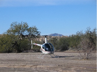
PhotoI looked for a place to land and found a large, clear area in the middle of the wash. It had rained several days before and had snowed up in the mountains. Areas of the was were still wet. I set down on a high, sandy area where the sand looked packed. I lowered the collective slowly once I’d touched down, watching my skid sink into the sand. It sunk in about an inch. Mike said there was no sink on his side. Satisfied, I shut down.

We took our picnic lunch, my new Canon G5 camera (which we’d used for the photo shoot), and a flashlight out of the helicopter and packed them in a canvas bag. Then we started walking. The cave was about 1/4 mile away. The walk to the base of the cliff was easy — gently sloping desert terrain with creosote, palo verde, cholla, and joshua trees. The slopes were cut with shallow washes — hundreds of them — that drained water into the wash. The ground was damp and relatively soft. There were no animal tracks and no signs of people.

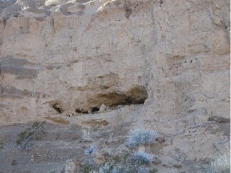
PhotoAt the base of the cliff, I stopped to take a photo of the cave. It looked very promising. In fact, I was sure I could see signs of a manmade wall inside the cave.

We started climbing up the side of the hill. It was easier than it looked. The soft soil made it easy to step up on. It only took us about 10 minutes to make the climb.

But when we reached the cave, we were disappointed. The cave was only a fraction of the size we thought it was. In fact, it couldn’t have been more than 20 inches high in its highest spot. The cave roof was stained by leeched water containing some kind of chemical. It made an interesting pattern in one area. The cave floor was littered with cholla spines. It was obvious that the cave had been used as a home by some kind of rodent — probably a pack rat.

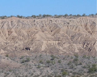
PhotoDisappointed, we made our way back down the hill. We stopped on a sunny spot and ate lunch, admiring the view across the wash, where years of erosion had eaten away the cliffs.

We walked back to the helicopter, climbed on board, and took off. We continued down the wash to the point where it joined the upper end of Alamo Lake. Then I turned east, flying up the Santa Maria River. I’d seen another cave the last time I’d been through and thought about visiting it, too. But I was kind of turned off to the cave thing after our disappointment. In any case, I didn’t see the one along the Santa Maria.

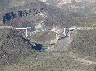
PhotoWe followed the river east to route 93 and explored some of the rock formations there. Some people on ATVs looked up at us as we flew over. Then we headed up the road to Burro Creek. Mike wanted to see the campground from the air; we were thinking about spending a few days there at the end of the month. He shot these two excellent photos. The bridge over Burro Creek. (Yes, it is possible to fly under the bridge, but we didn’t do it that day. The bridge isn’t the problem; the power lines, which hang lower than the bridge, are what’s scary.)

By this time, I was getting alarmed about our fuel situation. We’d left with about 22 gallons on board and had been flying for more than an hour. We decided to go straight home. I punched Wickenburg’s designator into the GPS and set a course. Unfortunately, the tailwind we’d had while flying toward Alamo Lake had become a headwind — about a 15-knot headwind. I dropped down to about 400 AGL, hoping to stay out of the wind. It didn’t help much. I watched the fuel gauges drop steadily. I pitched for my best range speed of 85 knots. We were still about 20 miles out when the Aux tank gauge got to E. I knew we had at least 15 minutes left on the main tank, but the GPS said it would take 17 minutes to reach Wickenburg. Route 93 was within sight. I decided that if the main tank gauge approached E while I was still 5 or more miles out, I’d fly over the road. Then, if the Low Fuel (read that “Land Now”) light went on, I could land close to the road and not have to walk far for a ride.

Fortunately, we made it to Wickenburg and I landed without seeing the light. But both fuel gauges were on E. I took this shot as I cooled down the engine; note the oil pressure; the engine really is running for this shot.

The trip had been fun, although a bit stressful. It was good to get out and fly with Mike; I’d been doing so much solo flying. But next time, I won’t let the fuel get so low.

The Kofa Cafe is Gone

One of my favorite fly-in destinations changes ownership and goes down the tubes.

The Kofa Cafe is gone. And I’m very unhappy about it.

The Kofa Cafe was one of my favorite fly-in meal destinations. About 50 nautical miles southwest of Wickenburg (bearing 240° as per my GPS), it was a great place to fly for a burger, some good chicken fried steak, or an ice cream sundae. I’d land in the back, among the creosote bushes and pencil cholla, off the dirt road so I wouldn’t kick up so much dust with my rotor wash. I’d shut down and walk in. Because no windows looked out at the back, no one knew I’d arrived by helicopter. I’d have my meal, visit the ladies room, pay, and leave.

Kofa CafeI wrote about my first landing at the Kofa Cafe in an article for wickenburg-az.com’s Day Trips section. I liked the restaurant’s big servings and down-to-earth atmosphere. I liked all the junk out on the front porch and in the yard. I liked eating with the truckers. I liked taking the helicopter someplace that wasn’t on an airport but didn’t get me in trouble. Three-Niner-Lima parked in the truck parking area the first time I visited the Kofa Cafe. The Cafe is the blue building.

The Kofa Cafe was for sale for years. No one wanted to buy it. Finally, the owners just packed up everything on the porch, locked the doors, and left. That was last spring. I’d arranged a helicopter outing there with our Heli Group and I found out the day before that the place had closed down. (We wound up going to Prescott instead. Not the same.)

But a few weeks ago, Mike and I had flown over in Mike’s plane. When I looked down, I saw cars in the parking lot. Perhaps the owners had come back. Perhaps they’d opened for the season. Today, I decided to fly out and find out.

Well, the old owners didn’t come back. Instead, there’s a new owner. He was there and he’s a certifiable jerk. He spent all of his time talking loudly to another customer, telling them how he runs the place so much cheaper than the last one. He complained about my waitress putting too much whipped creme (not cream) on my sundae — “I lose $2 every time she makes one of those.” He demanded to know why he was paying for iceberg lettuce and bagged salad. He claimed his property was worth “three quarters of a million dollars” and that’s why he lived in a motorhome there.

The guy was obnoxious, the place was sad. It had been open 24 hours a day. Now it’s open 12 hours a day, only 6 days a week. Half the menu items are gone. There are only three flavors of ice cream. The pies aren’t’ even made on the premises anymore. And I won’t even go into detail about the Alzheimer’s lady they leave sitting at a table by herself so they can keep an eye on her.

The waitress was unhappy. Frankly, I would quit rather than put up with her boss’s obnoxious behavior.

Needless to say, I won’t be back unless it gets a new owner again.

The Kofa Cafe is indeed gone — don’t let anyone tell you otherwise.

The Wayside Inn

A lengthy account of a trip for a hamburger.

Three-Niner-Lima’s attitude indicator was replaced for the second time in a month earlier this week. The first replacement unit I’d purchased had a “balancing problem.” It was a reconditioned unit ($970 vs $1,795 for a new unit) and the place I’d bought it from in Chandler repaired it at no cost.

The hobbs meter was replaced at the same time. A hobbs meter is like an odometer for an aircraft. It measures the amount of time the engine runs. It didn’t cost much to replace, but it can’t be preset with the previous meter’s number. So when I climbed into Three-Niner-Lima, on December 5, the meter read 0000.0. Very strange. The old one, which got terminally ill on my flight from Placerville to Mammoth CA, read 1068.5.

So it was two helicopter components that I needed to test that day. I wanted to give the new attitude indicator a thorough workout. And I wanted to make sure that the hobbs meter didn’t read 0000.0 when I got back from my test flight.

It was a beautiful morning when I took off from Wickenburg and headed west. My plan was to scout out the location of a house Mike and I were supposed to photograph in Forepaugh. The woman had given me a description that included phrases like “red roof,” “pasture of green grass,” and “round pen made of cut telephone poles.”The air was smooth and the wind was light, out of the south. I flew along highway 60, then altered course to fly over Forepaugh, where, as usual, nothing was going on. I headed for the first red-roofed house I could see. It had a round pen, but it wasn’t made out of telephone pole. And no green grass. A few more red-roofed houses were also the wrong ones. Then I caught a glimpse of green in the near distance. I flew over to investigate. Bingo.

All the time, of course, I was checking the attitude indicator. It was pointing straight up when I was flying straight and pointing to the appropriate side by the appropriate amount when I banked to the left or right. The first broken on had indicated I was doing aerobatics when I wasn’t. And the second broken one listed 5° to the right when I was flying straight. So far, this one was a major improvement.

I headed north, toward Robson’s Mining World off highway 71. Robson’s is a cluster of off-the-grid buildings nestled up against a small mountain range. It’s a picturesque place from the ground, with dense saguaro growth and other Sonoran desert vegetation around its quaint western buildings. Very quiet. I don’t fly over because I know the sound of my rotors would shatter the silence, which I consider one of the best features of the place.

Instead, I headed northeast along 71. There’s a place along the road where someone has spelled out “Congress Jct 15 mi” in rocks, complete with an arrow pointing to Congress. It’s hard to find sometimes and I decided to find a few landmarks near it so I’d be able to locate it any time I wanted to show someone. I found it and noted my landmarks.

The attitude indicator was still working fine.

I was done with what I’d planned to do, but I wasn’t ready to go back. I decided to fly along the back side of the mountains at Robson’s. I dropped down to about 300 feet AGL and flew across the empty desert, looking for interesting spots below me. I found a deep eroded washbed and began following that to the northwest. The wash widened. A few deer ran across it. I followed it with my eyes and realized that it went all the way to Alamo Lake.

Alamo Lake is a manmade lake (all Arizona lakes except one are manmade) north of 60, west of 93, and east of 95. It’s out there, in the middle of the desert, where the Bill Williams River, Santa Maria River, the Big Sandy Wash, Burro Creek, and Date Creek meet. The earthen dam was originally built for flood control downstream on the Bill Williams. I don’t think there are any canals or pipelines coming out of the lake and I don’t think the dam generates any power — except perhaps for the state park facility along the lake’s southern shore. The lake is popular with fisherman. It isn’t large enough for serious boating. Besides, it’s too far away from civilization. Heck, it takes about an hour and a half to drive there from Wickenburg. Add an hour from Phoenix and you have an inconvenient body of water.

Mike and I went camping there twice. The first time was in a tent, when we first came to Arizona to find a place to live. We were woken by coyotes, which we weren’t really familiar with, and Mike suggested that we sleep in the car. The car, at the time, was my Toyota MR-2, a microscopic two-seater. In my opinion, sleeping in that car was not an option.

The second time was in Mike’s old Suburban, with the horses. We camped in what the park people consider an equestrian campground. I think the single hitching post is what makes it equestrian. We couldn’t want for the ranger to bring water for the horses, so we rode them down to the lake. A completely silent electric-powered fishing boat glided into my horses view. It was his first experience with such a monstrous thing and he did what he usually did on first scary experiences: he got up on his hind legs and did a 180° turn, dumping me on the ground in the process. I still remember lying flat on my back on the sand (thank heaven it wasn’t rock), looking up at my horse’s face, which seemed to say: “What are you doing down there?”Anyway, Alamo Lake is a good place to get away to if you want to get away, especially if you like quiet. Other than that, leave it for the fishermen.

There are two main roads to get to Alamo Lake. The paved road, Alamo Lake Road, goes north from Wenden, which is about 50 miles west of Wickenburg. It crosses the valley, goes through Cunningham Pass, crosses another valley, goes through another pass, and ends up at the lake near the park entrance. The unpaved road, Alamo Road, goes west from highway 93, right around Date Creek. It’s well-maintained and follows the Date Creek wash, which cuts deep and wide into the desert on its way to the lake. Although it might be a shorter drive along Alamo Road from Wickenburg, it’s a dusty, dirty drive that requires 4WD in wet weather. So most people take the paved road.

Along Alamo Road (the unpaved road), about 5 miles short of the lake, is a place called Brown’s Crossing. It’s a crossroads out in the desert that used to have a store and gas station. Built to service the dam construction builders on their way to and from the dam in the 1960s (I guess Alamo Lake Road hadn’t been built yet), it was destroyed (I forgot how). The Wayside Inn was built nearby to replace it.

The Wayside Inn is a strange place. (And that is an understatement.) It’s a combination general store, bar, restaurant, pool hall, video rental place, and gas station in the middle of nowhere. Around it is a kind of town consisting of a collection of old, rickety, and somewhat sad trailers, motorhomes, and sheds. I bet about 100 people live there in the winter months. And it wouldn’t surprise me if most of them lived there during the heat of the summer, too. They seem pretty dug in and not the kind of people who have someplace else to go.

With the Wayside Inn as a destination, I followed the wash I was over, then Alamo Road. Then I dropped into Date Creek Wash, flying at about 200 AGL, which was just about level with the top of its cut. I saw plenty of animal tracks, as well as fences and corrals. Not many tire tracks. The rock formations near the end of the wash look like wet sand sculptures. In a few places, there are caves high in the rock walls. As I was climbing out of the canyon to go to the Inn, I thought I saw a cliff dwelling, and swung around for another look. Could be, but I’m not sure. I’d need to get out and explore. Another time, maybe.

An old airstrip had been carved out of the desert on one of the crossroads of Brown’s Crossing years before. It was not maintained and has various shrubs and other desert plants growing on it. Xs on either end tell pilots that it’s closed. I landed on it anyway, kicking up a huge cloud of dust. A man in a red shirt watched me land, then waited by a nearby fence for me to shut down and get out. When I apologized about the dust, he laughed.

This was actually my second time landing at the Wayside Inn. The first was during the summer, when I got a chance to fly a Bell 47 that was doing burro work for the BLM in the area. I’d arrived on a Wednesday, hot, hungry, and thirsty. The Bell’s fuel truck driver was parked on the old runway, reading a magazine. He told me that the restaurant was closed on Wednesdays. I finished my bottled water, then started on his before the Bell returned.

It was a Friday and the restaurant was open. The man in the red shirt told me where I could get through the fence, I followed his instructions, anxious to see what I’d missed that summer. And hungry. Along the way, I met the “doorman,” Charlie, a well-behaved pug who lived on a blanket beside the door.

I’ve already described what’s in the Inn, but I haven’t touched on its atmosphere. Imagine coming into a somewhat decrepit trailer park in the middle of the desert, miles from civilization, on a bright, sunny day. There’s no one around outside, but you hear the diesel generator that powers the place humming away nearby. You step up onto a porch where a cute ugly dog watches you expectantly, then step through an open doorway. Your eyes adjust to the relatively dim light and you see a bar with a television, a pool table, and a bunch of tables and chairs. You sit at the bar and take in the rest of the place, which is a mixture of practical and not-so-practical. Shelves of canned food, a strip of lights along the bar edge, fishing tackle, an ice cream freezer, a video game, shelves of videos for rent. Montel is on the television and although you can’t hear what’s being said, the picture caption tells all: “Racism in the same race.”There was a blond woman behind the bar. She was in her forties or fifties and her face was all made up as if she was ready to go out for a night on the town. She gave me a menu and took my drink order — iced tea since I was flying. Three other people were sitting at the bar, all men. Two of them were young, in their thirties, perhaps, and are probably fishermen. They were eating lunch. The other was older, the usual retired type you see around Arizona. He was drinking a beer.

I ordered a green chili burger and read about the history of the place on the back side of the menu. The older man, who was sitting two seats away from me, seemed as if he wanted to talk, so I started a conversation with him. I learned that he lived in Alaska during the summer and was staying in a camper on a mining claim north of the lake. I asked him how he got to the Inn from his place and he told me there were three roads, then started to go into detail about them. As I suspected, one of the roads wound through what he called “the jungle,” an area at the top end of the lake where you could cross when water levels were low. It got its name from the dead trees (probably cottonwoods) and dense vegetation in the area. It was the shortest route — probably only 10 or 15 miles compared to 40 or more on one of the other routes — but it required 4WD to get through sand and couldn’t be travelled safely when it was raining. When he asked, I told him I was from Wickenburg.

My food came and another waitress or bartender showed up. The man in the red shirt came in, too. We all chatted, talking about things like gambling in Laughlin, Schwan’s deliveries, helicopters, and places like Wickiup and Wickenburg. They told me about how Charlie the dog had reacted to that Bell 47 over the summer. He’d seen it come in for a landing and had run towards it, barking. The rotor wash had tumbled him away in a cloud of dust. He got to his feet and went at it again. But after a few landings, he’d lost interest. I hadn’t seen him coming toward me when I landed.

I asked if airplanes ever landed on the runway and was told that they usually just landed on the road. That started another conversation about one of the local residents who had converted a single-engine kit plane into a twin engine model that had a speed range of 25 to 125 miles an hour. The man in the red shirt had gone flying with him and had used up an entire disposable camera on the flight. The film, however, had been lost at a K-Mart one-hour processing place so they’d never seen the pictures.

It was almost 2 PM and I had to be at the airport to work at 3, so I paid my bill and left them. I took a photo of the outside of the place to remember it better. I’d had a good lunch in a weird place and would be back.

Photo
The entrance to the Wayside Inn. If you fly over, you can see its name on the roof.

Back in Three-Niner-Lima, I started up then stored a GPS waypoint so I could tell other pilots about the place. The coordinates are N 34° 14.72′ – W 113° 29.16′.

I took off and, since I was so close to the Santa Maria River (one of my favorite flights), I followed it upstream toward highway 93. I flew low for a while and was surprised to see a few houses down in the flood plain, not far from the lake. No signs of life, though. Just before I reached the deep canyon, I saw another cave that looked like it could have been a prehistoric dwelling. That one would definitely be worth checking out.

The rest of the trip was relatively uneventful. I flew out to 93, then followed that down almost all the way to Wickenburg. Along the way, I veered off to check out a few cattle tanks and people camping out in the desert. I got back to the airport with plenty of time to spare.

The attitude indicator worked fine and my new hobbs meter read 0001.5.

Living on the Edge of Nowhere

How a native New Yorker feels about living in a small Arizona town.

Wickenburg, where I currently live, is a small desert town about 50 miles northwest of downtown Phoenix, AZ. You drive through a lot of empty desert on your way to Wickenburg and when out-of-towners come to stay with us, they tell us we live in the middle of nowhere. No, I correct them. We live on the edge of nowhere.

We chose Wickenburg because of its small-town atmosphere, the affordability of housing (when compared with where we came from in northern New Jersey), the availability of services I needed to work (overnight FedEx, Internet access), and its relative proximity to a major airport (Sky Habor is 70 miles door-to-door).

In general, we got what we wanted. Our home, which was brand new when we bought it, sits on 2.5 acres of horse property near state land. We saddle up the horses right at the house and ride out on dozens of miles of riding trails. Our neighbors are far enough away that we don’t need to worry about closing curtains or blinds. We have real privacy, which I like. And peace and quiet, which I really like. I can work and keep in touch with my editors. And there are plenty of outdoor things to do, including horseback riding, off-roading, and hiking.

Wickenburg has just about everything we need to live comfortably, although there are some things I miss. Restaurants is a big one. Wickenburg’s restaurants are, for the most part, the plain vanilla variety where you can get a decent meal at a good price. But ethnic food is another story. There’s a very good German restaurant and several decent Mexican restaurants. There’s a Chinese restaurant, but it’s terrible (sorry, Mae). One restaurant, which is open during the winter season only, has very good “gourmet-style” (for lack of a better term) food, which is actually interesting. We try to go there at least once a month. For other food fixes — such as Japanese, Thai, and Chinese (we’re fond of Pacific Rim foods) — we have to go down to Phoenix or up to Prescott.

Wickenburg’s shopping is somewhat limited, too, although the Safeway Supermarket does a good job of meeting special requests. Certain types and cuts of meat are special order items; veal and lamb are seldom in the store. I have, on occasion, ordered a veal shank (for osso bucco) and a crown roast of lamb (for Christmas dinner). These items were extremely costly, but at least I was able to get them.

I work with computers and Wickenburg completely drops the ball when it comes to electronics. There’s a Radio Shack, but it’s run by a pair of morons who have serious attitude problems. I do most of my computer purchases via mail order or make a trip down to Fry’s Electronics on Thunderbird off I-17.

Wickenburg does not have a Wal*Mart (thank heaven), Home Depot, or Gap. It also doesn’t have a decent bookstore. Its singles scene stinks. So it will never be on anyone’s top-ten places to live.

Except, of course, retirement places lists. Unfortunately, Wickenburg always seems to appear on these lists. As a result, the town’s population doubles to 10,000 or so in the winter when old folk come down from the midwest and northwest to spend the winter where it’s warmer. And that’s where I’m having a serious problem living in Wickenburg.

The trouble is, these people (we call them Q-Tips because of their white hair) come for six months and act like they own the town. For the most part, they’re terrible (read that “dangerous”) drivers who are a real menace in parking lots and at intersections. They operate at a a speed that makes a normal Wickenburg resident look like the Roadrunner of cartoon fame, and makes a former New Yorker like me appear to be operating at light speed. They’re easy to bump into or trip over. They stop to chat in supermarkets and the post office, not seeming to notice that they’re blocking aisles. They seem to look down on local residents, perhaps because we don’t have two homes and they do — or at least a home and a motorhome that cost as much as a home. But the biggest problem is that they’re cheap and don’t want to spend money on anything in town if they can get it cheaper elsewhere. They cruise down to the Wal*Mart and other bargain stores in Surprise (40 miles way) regularly and whine about fuel prices in town. As a result, they don’t help support the local economy and they make it impossible for anyone to open a shop or restaurant that doesn’t cater to their cheap, white bread tastes.

Do I sound like I can’t stand them? In general, I can’t. There are a few exceptions, although I can’t think of any at the moment.

The other problem with living among all these old people is that you start to feel old, too. You start to wonder why, at the age of 42, you’re living in a retirement town. You’re not retired. You still have a lot of good years ahead of you. So why the hell are you living in a place where old people come to spend their last winters?

If the winter isn’t depressing enough, the summer can be sheer hell. In July and August, during the monsoon season, daily temperatures go into the 100s and 110s, with humidity sometimes peaking at 30% or more. It’s a nasty combination that makes it difficult to do anything outdoors. So we spend a lot of time indoors. Or in the air conditioned car. Or in the air conditioned store.

So Mike and I are seriously considering a move. To someplace that doesn’t get so damn hot in the summer and isn’t packed with the 55+ crowd in the winter. To someplace where we can feel alive, all year around. Where we can still get the peace and privacy we need to be happy.

If you know of such a place, let me know.

Placerville, CA to Wickenburg, AZ – Day 3

The journey continues…and finally comes to an end. There’s no place like home.

On Sunday, I woke at the usual time, made coffee in the little coffee maker, and started packing. Since I’d never really unpacked, I started by doing that. After all, I had at least three hours before I’d be able to leave. I had to do something with that time.

So I packed and watched the Weather Channel. They were forecasting clear skies and light winds for the southwest. Sounded good to me. Local temperatures were around freezing and winds were 5 to 10 miles per hour. The FBO, which I’d called the day before, didn’t open until 8:00 AM. I planned to be there when it opened. I wanted to be in the air by 9:00 at the latest.

I took a long, hot shower and dressed in clothes that were of questionable cleanliness. I’d been smart enough to wash all my clothes at Liz’s house three days before, but I was on my last pair of underwear and I’d only brought three longsleeved shirts along. Fortunately, I had plenty of socks.

I called the taxi company at 7:10 AM and woke up the cab driver. I asked him to pick me up at 7:45 for a trip to the airport. Then I gathered up my belongings and went downstairs to check out.

I left my luggage in lobby and went across the street to get a large latte and roll at a bakery there. I still had my headache and my stomach wasn’t feeling quite right. Migraine, I knew. But I couldn’t take my regular collection of painkillers when I was going to fly so I had to deal with it. I certainly felt okay to fly: alert and eager to be on my way. This headache wasn’t going to stop me.

The cab driver arrived in a van. He was wearing a short-sleeved shirt and was shivering. The van hadn’t warmed up yet and it was freezing outside. He claimed to have forgotten his jacket. How someone can forget to bring a jacket outside when it’s freezing is a mystery to me.

At the FBO, things were warm inside. One of the two women who had been there on Friday was already there. I went with the line guy on duty to retrieve Three-Niner-Lima from the hangar. We pulled it out onto the ramp and I started my preflight while he went to get the fuel truck. Everything looked fine, although I did need to add oil. I loaded my luggage and set up my iPod. I put my bottle of water where I could reach it. I organized my charts. Then I went back to the FBO office with the line man to settle my bill. Fuel was $3.49 a gallon there — that’s $1.10 per gallon higher than Wickenburg. The bottle of oil I bought to replace my empty was $6.50. And the hangar was $50 a night, although she only charged me $50. Between the hotel stay and the FBO charges, Mammoth had not been a cheap stopover. But I’d take it over Rosamond any time.

The line man gave me another lift to Three-Niner-Lima. I told him that if I wasn’t gone in 30 minutes, I probably would be staying for the day. I checked the fuel caps again, climbed in, and buckled up. Although the hangar had been heated, the thermostat had not been set to 68°. The ship was still cold. I gave it two pumps of the primer, then started it up. It ran extremely rough and I think carburetor ice was the culprit. I pulled the carb heat level to full and, as the engine began to warm, some of that warm air made it into the carburetor. It smoothed out. I settled back to wait as the ship warmed up.

A twin taxied past me, to the end of runway 09. By the time I was ready to go, he still hadn’t departed. He finally made a call, then took off. When he passed my position, I picked up into a hover, adjusted the carb heat to full again, made my call, and took off after him.

My the first half of my first leg would be easy. I’d follow the highway — route 395 — southeast, past the towns (and airports) of Bishop, Independence, and Lone Pine. This route was in a deep valley with elevations dropping from 7128 at Mammoth to 4120 at Bishop and 3680 at Lone Pine. The Owens River and an aqueduct ran to the east of the road. The Sierra Nevada Mountains ran along the west side of my path and the Inyo Range ran along the east. Both ranges were snowcapped and beautiful, especially in the early morning sun.

The day was clear and the winds were calm. It was perfect flying weather, except for the cold. At one point, my outside air temperature (OAT) gauge read -2°C. The cabin stayed pretty warm, though, with the morning sun shining into the bubble. I was wearing my baseball cap, to keep the sun out of my eyes.

Other than the mountains and the river beside me, the only other point of interest I passed on that first part of the trip was an array of radio telescopes, or “telescope antennas,” as they were identified on my sectional chart, south of Bishop. Although they were east of my route, I swung over to take a look — and a photo — without getting close enough to affect them.

Photo
An array of radio telescopes in the Owens Valley.

The airports along the way were pretty much dead. Bishop, which I didn’t fly directly over, had three runways; it must have been a busy place at one time. The choice of runways probably made it a favorite alternate for pilots who feared Mammoth’s crosswinds. Independence and Lone Pine were nothing more than paved strips. I passed another closed runway along the way and I wondered how long before there were big Xs over the runways at Independence and Lone Pine.

At Lone Pine and Owens Lake (mostly dry), my route got a little tricker. I had to head east, crossing the ends of several mountain ranges, to get into Death Valley. There were a few roads that went my way, but I couldn’t follow just one of them. The trouble with following roads from the air is that you can’t read the road signs. That makes it very easy to take the wrong road when you have a choice. Although some roads appear on a sectional chart, my GPS doesn’t show roads. So to navigate, I need to closely follow my path on the chart while relying on my GPS to point me in the right direction for the next waypoint, keeping in mind that I probably won’t be going on a straight line.

Photo
Owens Lake. The reflections of the mountains in the calm water (where there was water) were beautiful.

Why not a straight line? Well, in this case, the darn mountains were in the way. When you’re cruising along in a valley at 500 feet AGL, climbing over mountains just to follow the shortest path isn’t always practical. For example, if I were flying at 4000 feet MSL and I needed to go over a 7000 foot mountain (which meant a climb to 7500 feet or thereabouts), I’d have to climb. My best climb speed is about 60 knots, so I’d have to slow down. Say I could climb at 500 feet per minute at 60 knots. It would take me 7 minutes at that speed to reach the elevation I needed to cross the mountains. Up there, I could be subjected to higher winds and mountain waves (caused when winds cross over mountains and mountain ranges). But if there were a mountain pass just a few miles away, I could detour and slip through that, without climbing as much or dropping speed. While the detour might still take longer, it wouldn’t take much longer and it might be a more comfortable ride.

That’s my take on it, anyway. Other helicopter pilots might have different opinions. Airplane pilots can’t understand this argument at all, since they’re already flying at 10,000 or more feet to go from point A to point B. (They’re also not admiring radio telescopes in the desert and flocks of birds over lakes.) On this part of my journey, I also had to switch from the San Francisco sectional chart to the Las Vegas sectional chart, which I’d borrowed from Rod (mine was in my ship when I was doing my flight planning). Switching charts always makes life interesting, when you’ve only got one hand to do any kind of work. But since my charts had been prepared before I left, it wasn’t so bad.

I headed east at Owens Lake, crossing the mountains in the gap between the Inyo and Coso Ranges. I entered the boundaries of Death Valley National Park and followed a road to Panamint Springs. There wasn’t much going on there, but I did notice a few vehicles, including a motorhome, parked on an overlook for the valley I’d have to cross. I wondered what they thought of the tiny helicopter making its way eastbound.

I followed a road across the dry lake bed at the northernmost end of the long valley, marveling at the sand dunes to my left, which were clearly marked on my chart. The road turned northeast and climbed into a pass of the Panamint Range.

Photo
Telescope Peak, which rises over 11,000 feet from the desert floor, was snowcapped and looking beautiful in the midday light.

I followed the road down to Stovepipe Wells, which has a tiny paved strip walking distance from a store, motel, and campground. I’d flown there in May, on my trip to Death Valley, and had regretted it. It was a long walk to the store for a Gatorade and a long walk back to my helicopter.

I was now in Death Valley proper. I headed southeast around the end of the mountain range and zeroed in on Furnace Creek. As usual, it took me a few moments to actually see the airport. Imagine the floor of Death Valley as a dry lake bed, which it mostly is. The airport is on the east bank of that lake and, beyond it, are the campgrounds, lodges, and other facilities that tourists visit. There’s even a golf course — the lowest one on earth. I made a few radio calls and got no response, so I just landed at the pumps. My altimeter read -200.

I’d been at Furnace Creek Airport before, so I knew the drill. I left my ship and headed over to a building where I found a house phone, a pay phone, and a restroom. I took care of business in the restroom first, then used the house phone to call the Chevron station. A while later, a white pickup pulled up to the pump with two men on board. They unlocked the pump, unwound the hose, and let me do the filling. I topped off both tanks and they put everything away. A plane flew overhead, landed, then parked while we worked. Then we all climbed into the pickup truck for the mile or so drive to the Chevron station, where I could pay.

After settling my bill with them (20+ gallons at $3.20 a gallon!), I called for a shuttle ride to the Furnace Creek Inn, where I hoped to get a good meal. The driver was friendly. He told me that the park would get very busy on the upcoming Thanksgiving Day weekend. He dropped me off at the Inn and I gave him two dollars for his time.

At the Inn, I was in for a special treat. First of all, you have to realize that the Furnace Creek Inn, which is a historic monument, is also a 4 diamond resort, as rated by AAA. It’s a nice place. It sits on a hillside overlooking the valley and the Panamint Mountains beyond. It has a pool and tennis courts and a very good restaurant.

Photo
Furnace Creek Inn.

What I didn’t know was that the restaurant had a Sunday brunch. And my arrival at 11 AM was just in time for it to begin.

I ate curried chicken salad, chilled asparagus, two kinds of caviar, smoked trout, smoked salmon, and seared ahi tuna. I ate osso bucco, risotto, and roast beef au jus. I ate other things that I can’t remember. All while sitting at a window table, overlooking the stark, silent beauty of Death Valley. The view from Furnace Creek Inn.

Sure it was expensive, but so what? You only go around once, and I don’t like to skimp when it comes to eating good food.

By 11:30 AM, I was ready to move on. The same shuttle driver took me back to the airport. I gave him another two bucks. Then I checked the fuel caps and the oil, climbed aboard, started up, and departed to the east.

I followed the main road past the Inn and out of the valley. I climbed with the terrain, about 400 feet per minute. Once outside the Valley, I set my GPS for my next waypoint, Shoshone. I’d cross a lot of empty, lonely desert to get there and, once there, I kept going toward my next waypoint, Jean, NV. Jean featured a pair of runways beside a pair of casinos on I-15. I never quite made it to Jean, though, because I steered too far to the south. When I came out of the Pahrump Valley, I saw Jean about 10 miles north of my position. So I set my GPS for my next waypoint, Bullhead City.

There isn’t much to say about my leg from Death Valley to Bullhead City because it wasn’t very interesting. The terrain was standard southern California/Nevada desert. That meant a lot of mountains and valleys with very little vegetation or signs of civilization. It was odd to see a road in many places and even odder to see a car on it. Not the kind of place you’d want to land if you didn’t have to. Cell phones would not work — no question there. Nights would get cold. It would be a long walk to help. And wildlife would include predators, like coyotes and perhaps mountain lions. Well, maybe not mountain lions, but definitely coyotes.

But when you spend as much time flying in the desert as I do, you get used to the isolation. And you bring along some supplies that might help you if you do need to land in the middle of nowhere. I carry a small green bag filled with emergency supplies. It contains matches, a signal mirror, some water, a space blanket, medicines, first aid supplies, a yellow bandana (sun shade, signal flag, tourniquet, etc., all in one!) a scissor, an extremely high quality all-in-one tool (like a Leatherman, but better), and lots of other goodies. I don’t carry this bag with me on all trips, but I did carry it on this one and I usually carry it when I fly alone and know I’ll be crossing wide expanses of nothingness. Hell, I don’t want them to find me dead with nothing on board that could have helped me.

I’m looking at my charts and noticed something I failed to mention throughout this narrative: the MOAs. MOA stands for Military Operations Area. It’s a place that the government has set aside for its military pilots to practice in. The southwest is full of MOAs. On this particular day, I passed through a bunch of them: Bishop, Owens, Panamint, Shoshone, Turtle, Bagdad 1, and Gladden 1. Each MOA has its own operating hours, altitudes, and controlling agency. When you pass through an MOA within its operating altitude during its operating hours, you run the risk of interfering with a military training exercise.

As a helicopter pilot, I normally fly below operating altitudes of MOAs. For example, the Gladden 1 MOA’s floor is at 7000 feet MSL or 5000 feet AGL, whichever is higher. I fly at 500 AGL, so I technically don’t fly in the MOA’s airspace. But I often see the F-16s from Luke Airforce Base (south of Wickenburg) streaking across the airspace in pairs, occasionally breaking the sound barrier. And I was once “buzzed” by four F-16s as I crossed through the northeastern corner of the Bagdad 1 MOA at a 80 knots, 500 feet up, minding my own business. Talk about a wake-up call!I can’t remember if I read this or saw it on one of the King written test videos, but the advice was to avoid MOAs at all cost. A pilot in the southwest couldn’t do that. If he tried, he’d severely limit where he could fly. The proper thing to do is to contact the controlling agency to see if the MOA is “hot.” If it is, you should stay out of it.

But I didn’t make any calls. I just flew through at 500 AGL, too low to get in anyone’s way. Heck, I have a transponder. They can see me. Besides, it was Sunday and I figured all the pilots would be back at base, watching a football game.

I passed between Searchlight and Kidwell, flew over the northern end of a small mountain range, and saw Lake Mohave before me. I planned on following the lake south to Bullhead City.

As I rounded the bend and crossed the lake, the wind picked up. I looked at my GPS. I had a 20 knot tailwind. Yee-ha! Ride ’em cowgirl!I called Bullhead City tower when I was still 10 miles out. Things were quiet, as usual. That place is always quiet. The controller told me the winds were 25 knots from the north. No fooling. He told me to report one mile north.

I closed the distance to the airport in record time and reported as requested. The controller told me to land direct to the helipads. That would have me landing with a 20+ knot tailwind. Not a chance. I asked to do a left downwind along the river. He told me to proceed as requested. I came down the river and tried to make my base turn short of the Home Depot parking lot, so I wouldn’t overfly it. The wind wouldn’t let me get away with that and blew me right over the lot, sideways, about 200 feet up. Must have given customers in the parking lot a good show. Look at that tiny helicopter, flying sideways. Fine. I pointed into the wind and headed toward the pads. Eventually, I made it, touched down, and shut down.

I called for fuel and they sent a golf cart instead of a fuel truck. Seems I had to go inside to place my fuel order. I told the woman at the desk to top off both tanks. By that time, she was distracted by the arrival of a Citation jet that would probably take on a lot more fuel than I would. I retreated into the bathroom, which was filthy and didn’t have any toilet paper. Fortunately, I had some tissue in my shirt pocket. It was the worst stop I ever made in Bullhead City and I sincerely doubt whether I’ll buy fuel there again.

A while later, at about 3:15 PM local time, I was airborne, on the last leg of my trip. The tailwind stayed with me for most of the flight. It was a direct flight from Bullhead City to Wickenburg, with no intermediate waypoints. I passed east of Grossman Peak (near Lake Havasu) and east of Alamo Lake. I crossed a lot of empty desert. But this was familiar desert, desert I’d flown over dozens of times — if not more.

I started my radio calls to Wickenburg from just north of Alamo Lake, 50 miles out. No response. Again at 40 miles out. No response. Again at 30 miles out. No response. I finally got a response at 20 miles out: Alta giving me the wind speed and direction and unofficial altimeter setting. “Welcome home,” she added.

I touched down in Wickenburg at about 4:30. Thanks to the tailwind, I’d made record time from Bullhead City, which was over 100 nautical miles away.

Mike drove in just as I was shutting down. He helped me offload all my bags, including the bag of apples and mandarin oranges I bought in Placerville for him.

After a week away, it was good to get home.