Water, Anyone?

I haul water for the first time.

“Off-the-grid” is a term that applies to property without access to public utilities like electricity, gas, telephone, cable television, and water.

By this definition, our home in Wickenburg is only partially “on-the-grid.” We have electricity and telephone but live beyond the range of cable television and town water lines. (I don’t think gas is available anywhere in town other than in tanks.) We have Dish Network, so we don’t need cable. (Ironically, Internet is provided wirelessly through the local cable company.) And we get our water from a well we share with the house next door.

Our place on Howard Mesa is utterly and completely off the grid. We get electricity through a small solar system Mike installed on our shed. We get gas delivered to a tank on the property. We use our cell phones for telephone service. We don’t have any kind of television or Internet. And water…well, it has to be hauled up to the property.

While it is possible to dig a well for water, this area of Arizona is notorious for its low water table. A well might have to go down thousands of feet to hit a good water source. It’s just too darn expensive to dig that deep. So most folks have water tanks and either hire a water service to keep them full or haul water themselves.

We have two tanks with a total capacity of 2,100 gallons. Because we don’t live up here full time, we only fill the tanks once every two or so years. Since we bought the property, we’ve had the tanks filled four times by water services (once because a crack in the valve drained a tank over the wintertime and once because I found a dead animal in one of the tanks). But when I called three different water services to fill the tanks sometime this week, none of them would come. (It appears that we’re not the only ones who have had bad experiences with the roads here.)

Not a big problem. Our friends Matt and Elizabeth, who live full time on the other side of the mesa, haul their own water. They have one of those water tanks that fit in the back of a pickup truck. It holds 425 gallons. They said we could borrow it, and the transfer pump we’d need to move water from the portable tank to our tanks anytime.

Loading the Water Tank
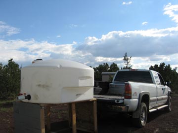
I picked up the tank yesterday. Matt had created a platform for it that made it level with the back of the truck. It was just a matter of sliding it off the platform and onto the tailgate, then lifting it slightly to get it over the wheel wells. Close the tailgate and it’s in.

Elizabeth also gave me their pump. It’s a black cylinder that stands upright in the bottom of the tank (on the inside). A power cord and a hose come out of the pump.

I went into Williams today to do some laundry, get on the Internet for a while, hit the Post Office, and pick up a few things at the local hardware store. I stopped at the water “store” — Running Water, which was also one of the water services that wouldn’t deliver to the top of Howard Mesa — on the way back. I pulled in behind a man with a pickup truck towing a trailer with the same 425 gallon tank I had in the back of my truck. I shut the engine, and got out.

“Mind if I watch?” I asked. “I’ve never done this before.”

“Sure.”

He’d parked his tank right under an orange, flexible hose with a 2 or 3 inch diameter. As I watched, he pulled a piece of black plastic pipe with a 4 or 5 inch diameter and stuck it into the top of his tank. He put the orange hose inside that.

“I use an extension,” he told me. “My tank is so low that sometimes the water pressure pushes the hose out while filling. The extension keeps it in.”

He walked to the machine the hose was connected to and inserted a ten dollar bill. The water immediately began gushing through the hose and the extension and into his tank. He put another quarter in.

“I like to fill it all the way,” he said. “This way the water doesn’t slosh around while I’m driving.”

We watched the water fill his tank. It was white and somewhat transparent and the water looked blue. While we waited, we talked about the price of water going up because the price of fuel had gone up. The water at Running Water is hauled to the site, probably from Flagstaff or Belmont. The more water you got, the cheaper it was. But not everyone could haul thousands of gallons of water. 400 gallons for $10 seemed to be the most popular quantity. That made it 2.5 cents per gallon.

The water rose into the neck of his tank and stopped just beneath the 425 gallon mark. The man inserted another quarter. A moment later, the water was overflowing in the tank, splashing all over the trailer. He pulled out the flexible hose, which was still flowing water, and his extension. He put the extension in the back of his truck and came back to fasten the lid on his tank.

“Have a good day,” he said to me. Then he climbed into his truck and rolled away.

I pulled up carefully, aligning the orange hose over the top of my tank’s fill port. Since my tank was high on the bed of the pickup, I wouldn’t need an extension. I got out, checked the position, then moved the truck back about six inches. I killed the engine. I took the lid off the tank and inserted the orange hose in it. Then I slipped a ten dollar bill into the machine. The water started gushing; the hose stayed in place.

While I waited, a woman pulled up in a pickup truck with a smaller tank on the back.

Although I didn’t want the water to slosh around in the tank, I also didn’t want to get water all over the back of the truck. I’d bought three bags of mortar and I didn’t want them to get wet. So when the water stopped flowing short of the 425 gallon mark, I was satisfied. I pulled the orange hose out carefully and let the water in the hose run into the tank. Then I pushed it aside, fastened the lid on the tank, got into the truck, and drove off.

Let’s do the math here. A gallon of water weighs about 8 pounds. I had 400 gallons, which totaled 3,200 pounds. I also had the tank itself, which probably weighed about 50 pounds, 3 80-lb bags of mortar, and a 20-foot length of 1/2 inch re-bar, cut into 4 pieces. So I was hauling at least 3,500 lbs of stuff in the back of that truck.

That’s why we have a truck. Because we haul stuff.

It was 10 miles back up Route 64 to the turnoff for Howard Mesa, then 5 miles up those nasty unpaved roads. The speed limit on Route 64 was 65, but I soon discovered that when I got my speed over 60 MPH, I could feel a certain amount of instability in the truck. I don’t know if I was imagining it or if it was because of the gentle sloshing around of the water, which I could watch in my rearview mirror. So I kept my speed between 50 and 60 MPH and signaled for my turn long before I reached it, letting the truck slow to 40 MPH before I got into the turning lane. I didn’t want to have to jump on the brakes. I also took it very slowly up the roads to our lot, keeping my speed between 10 and 20 MPH the whole way.

Pumping Water
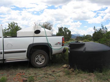
I arrived without incident and backed the truck up to our small, 550 gallon tank, which I’d been using to keep the horses’ water trough filled. After letting Jack the Dog out to supervise and putting my lunch on the stove to reheat, I went out to transfer the water from one tank to the other. I started by lowering the pump into the bottom of the tank and running its hose into my tank. Then I plugged in the pump, using an extension cord from the shed. The pump started pumping, sounding strangely muffled from deep inside the portable tank. The water rushed into the other tank.

Elizabeth had said that it took 20 minutes to transfer a whole tank of water from one tank to the other. That sounded a little too quick for me. So I timed it. I also filled the horses’ water trough to make room for the incoming water. Whatever didn’t fit in the small tank would go in the larger one. But I was trying to use up all the water in the larger one so we could move it closer to the shed. Can’t move a 1,550 gallon water tank when there’s water in it.

I was standing by the tank, monitoring its pumping progress, when the pump sounded like it was trying to suck air. I unplugged it. My tank was nearly full. The portable tank was nearly empty. It had taken 38 minutes to make the transfer.

A lot of people think it’s some kind of crazy ordeal to haul water. I guess it would be if I had to do it every day. But this was the first time I’d ever had to do it — and we’ve owned our place at Howard Mesa for over six years. It wasn’t difficult at all. It wasn’t even inconvenient. I picked it up on my way home, then transferred it from one tank to the other while making and eating lunch.

I figure that between me and the horses, we probably go through 30-40 gallons of water a day. The horses are the big consumers; on a hot day, they’ll drink 15-20 gallons each. I don’t drink this water; I drink bottled water and we have 5 gallon water bottles we fill at home and bring up here for cooking. So this 400 gallons — plus the 300 or so gallons I had to start out with — should last about 20 days. With luck, we’ll have the bigger tank drained and moved before the end of the season. Then we can top off both tanks in three trips and be all set up for the winter (if we come up here) and next summer.

Next summer, I hope to put up a shade structure for the horses. It’ll have a gutter on the lower side of its roof to collect rainwater and dump it right in the horses’ water trough. With monsoon rains the way they are, the trough should stay full from the beginning of July through the end of August.

I will admit one thing about having to haul water: it really makes you conscious about how much water you use. You don’t let the water run in the sink when you know that every drop that goes down the drain is just another drop you’ll have to haul up one day in the future.

[composed on top of a mesa in the middle of nowhere with ecto]

water, tank, Williams, Arizona

Heat

Phoenix residents snicker.

A heat wave is spreading across the country, giving people in the west, midwest, and northeast a taste of what Phoenix residents experience from June through September every single year.

Heat is serious business in northern latitudes. Many homes were built long before central air conditioning became a “necessity” of American life. The “lucky” people in those older homes have window air conditioning units that they install and remove on the same schedule they use to store and unpack their winter clothes. In some areas of the northwest, air conditioning is rare — since serious heat waves are also rare. And in low income homes, even the window air conditioner isn’t an option since the occupants often can’t afford to purchase such a luxury item. People are being overcome by the heat, getting sick, and dying.

To make matters worse, air conditioners use power and the power suppliers in these areas aren’t accustomed to meeting the additional demands of air conditioner users. Brownouts and rolling blackouts are all too real. You know things are bad when the media recommends unplugging cell phone chargers and televisions when not in use to limit the amount of “vampire power” these devices suck from the grid — an estimated 10% of all power use.

Meanwhile, Phoenix temperatures are below normal, in the high 90s and low 100s. The other day, it was hotter in South Dakota than it was in Phoenix. How’s that for a switch? It has some people in Phoenix snickering. After all, we tease people up north about their snowfalls and low temperatures in winter and they tease us about our hellish summers. Now we can tease them about hellish summers, too.

I’m still up at Howard Mesa where I went to escape WIckenburg’s heat — which is slightly more bearable than Phoenix’s. It’s 20° cooler here — in the 70s every day lately. Relaxing in the sun is actually something I like to do here. The other evening, as I lounged reading a book, I kind of wished I had a little blanket to tuck around me. (My blood certainly has thinned out since I left New Jersey 10 years ago.)

Yet every day, as I listen to the news on NPR, I hear about the “sizzling” heat in one place or another and the emergency cooling centers and the efforts to check on elderly people living alone. Hard to think about such heat when you’re not experiencing it.

I remember those 80/80 days in New York — that’s 80° with 80% humidity. That heat was brutal and I’d prefer a spot of shade in Phoenix in August over that. Now it’s over 100° in New York. Those people must be melting.

One thing for sure: none of my family or friends back east are teasing me about the Arizona heat right now.

The Roads of Howard Mesa

Yet another expensive auto repair.

Our place at Howard Mesa Ranch is on top of the mesa, five miles from pavement.

When we bought our place from the original sales organization, the roads, although unpaved, were in pristine condition. I never saw a grader at work there, but the roads were always smooth and wide. Our sales guy, Larry, took us around in his old Buick sedan. That was six years ago.

Although Mike and I never expected the roads to be kept in that same great condition, we expected them to be kept in passable condition. Certainly by a Jeep or 4WD pickup truck — even while towing horses or a camping trailer. Hopefully by a sedan if driven carefully in dry conditions.

Flash forward several years. Road maintenance dollars, divvied out by the Property Owners’ Association, goes to the people who complain the most — who also happen to be the people who live closest to pavement. One of them whines that his road needs to be maintained so construction vehicles can reach his lot. One of those vehicles gets stuck and the POA pays to have it towed out. Dollars that should be spread around evenly on the roads that service all owners are laid on thick on the south end near Highway 64.

July 2004. I was living in a trailer on our Howard Mesa lot, working at Papillon at the Grand Canyon. I drove my Jeep down from the top of the mesa early in the morning to get to work by 7 AM. I hit a pothole in the road hard and instantly hear the sound of air hissing from the tire. I was still two miles from pavement and managed to get a mile closer before the tire was completely flat. Another property owner helped change the tire. The damaged tire could not be repaired. Replacement cost: $152.

August 2004. I’d flown to work that day in my old R22 helicopter, but storms in the area convinced me to leave the helicopter at the airport and drive home. My 1987 Toyota MR-2 was at the airport. I’d driven it on many occasions to and from our lot. But that day would be different. On that day, I’d get stuck in the mud two miles from my gate. I walked to my trailer in the drizzling rain, still in my uniform, as the sky darkened around me. A shortcut through a field got scary when I heard coyotes howling nearby and realized that I had nothing to protect myself from them. No damage to the car; just inconvenience. I came back two days later when the ground was dry and managed to make it the rest of the way to my lot.

October 2004. I take my Toyota to get an oil change. The quick lube place refuses to do the job. The oil pan is smashed in and they’re afraid they won’t get the plug back in after they remove it. The oil pan, which was obviously damaged while driving at Howard Mesa, has to be replaced — I don’t take the car off pavement anywhere else. Total cost $312.

May 2005. Mike and I bring our horse trailer with living quarters back up to our lot for the summer season. Erosion has narrowed the road in places. The 35-foot long trailer slips into a ditch on the driver’s side, smashing the valve for the black water holding tank. We get it back on the road. It then slips into a ditch on the passenger side, smashing the step to the trailer door. Total cost: $268.

May 2005. The next day. Mike and I take his truck on the other road that climbs up to our side of the mesa to see if it’s any better. It isn’t. It’s worse. The 4WD truck slides into a deep, mud-filled ditch. Another property owner tries to pull us out with his Jeep when our truck’s 4WD low setting doesn’t do the trick. The truck is stuck fast in the muck. AAA refuses to send someone to tow us out. We pay a local tow company to do the job. Total cost $250.

We make a lot of noise at the POA annual meeting. It wakes up the POA decision makers. They finally start spending some money on road maintenance on our part of the “ranch.” They grade the state road and spread cinders in the most slippery spots. They put in culverts. But the money runs out before the job can be finished. The road is much better, but has a few very tough spots to negotiate, spots where tire placement can mean the difference between clearing the ground and bottoming out. Yet last week the cinder truck spread cinders on a perfectly smooth road that is never even used. Could it be because there are two lots are for sale on it and the owners wanted the road to look “maintained”? That road is only about a mile from pavement.

July 2006. Today. MIke has driven up for the weekend in his Honda Accord. He’s driven very slowly, very carefully. But he still bottoms out once on his way down this morning. The oil trail starts about a mile short of pavement. His car’s oil light went on three miles south of the Howard Mesa turnoff on Route 64. The oil pan is so torn up that Mike can stick his finger in it. Total cost: unknown so far. But the tow to Williams was $89, the rental trailer to bring the car from Williams to a Honda dealer in Flagstaff was $64, the rental car so he could get to work tomorrow was $86. He missed work today. The cost of the oil pan and replacement labor will probably exceed $300.

[August 1 Update: The Honda’s engine damage was severe and the engine needed to be replaced. Thank heaven it was covered by insurance. It would have cost thousands of dollars.]

It struck me today that we spend more on repairs to our vehicles due to road conditions than we do on property taxes, POA dues, and even hauled water combined. What’s wrong with this picture?

There are a lot of lots for sale at Howard Mesa Ranch. If you’re thinking of buying one, be sure you talk to the POA about maintenance on the road to your lot first.

Then, if you do buy, go out and get a high clearance 4WD vehicle. You’ll need it.

[composed on top of a mesa in the middle of nowhere with ecto]

Grand Canyon Back Roads and Trails

We take the Jeep on some forest roads at the local park.

Now that work on our shed at Howard Mesa is just about complete, we can spend more of our time in the area on recreational activities. Yesterday, we spent the day doing one of my favorite activities: back road driving in my Jeep.

I need to clarify something here. A lot of people think that when you drive on some of the unmaintained yet marked dirt roads that wind through places like national forests and state parks, that’s off-roading. It isn’t. After all, how can it be off-roading when you’re following a road? Sure, the roads are in terrible shape sometimes. Sure, they have huge erosion ditches running down one tire track or the other or sometimes right across the middle. Sure, there are no signs other than those with the secretly coded forest road number, which may or may not match the number on your detailed forest service map. But they are roads. So when you drive on them, you’re not off-roading. You’re driving off-pavement.

Of course, if you’re a city slicker and your SUV tires have never had dirt or gravel between their treads, you probably wouldn’t even attempt the roads I’m talking about. After all, my sister-in-law, on her first visit to our house, exclaimed, “Wow! This is the first time I’ve ever been off-road!” That would have been fine if we were driving off-road at the time. But we weren’t. We were driving down the only road to get to our house. And her husband, my brother, owns a Nissan Pathfinder.

I remember when my mom and stepdad came to visit years ago, driving to Arizona from Florida in their Mercury Mountaineer. We decided to take them to Box Canyon, which is up the Hassayampa River a bit. Rather than all cram into my Jeep, we climbed into their SUV. I can’t remember who drove, but I do remember my parents’ cries of alarm when they realized that we were actually going to drive in the river to get there. “But this is an SUV,” we countered. “It’s designed to drive places like this.” Needless to say, their vehicle stayed parked in our driveway for the rest of their stay, lest they should be tricked into taking it off pavement again.

Can someone explain to me why people buy SUVs when they’re afraid to drive them on anything but paved roads and highways?

Did you ever notice how I can take a short story and make it really long?

Anyway, that’s what we did yesterday. We took a 40-mile off-pavement drive.

I had my extremely detailed forest service map for the Kaibab National Forest, Tusayan Ranger District. That’s the area of the Kaibab National Forest that butts up against the southern part of Grand Canyon National Park. The map included dozens of forest roads with numbers like 305, 301A, and 311. Narrow, two-track roads that wound their way through the ponderosa, pinyon, and juniper pines, along ridges, over creeks, and alongside rocky outcroppings. The map included several “places of interest” marked with red “i” icons. One was the Grandview Lookout tower, which I had visited two years before (and wrote about it in this blog; try searching for Grandview; I can’t link to it while composing offline). Another was someplace called Russell and yet another was a place called Hull Cabin in the Hull District. I wanted to visit all of these places. And I didn’t want to get there the fast way.

Although I can provide the road numbers here, they aren’t much use unless you either have a map to consult or are in a high clearance vehicle — I didn’t use 4WD at all — and want to follow my path. I suggest the latter.

We took Route 64 north, toward Tusayan and the Grand Canyon. A bunch of miles past Valle (crossroads with route 180 from Flagstaff), and just past Red Butte, we turned right onto Forest Road (FR) 305, which is indicated as an “improved” gravel road on the map. The map is from 1995 and that may be the last time they laid down gravel there. We followed 305 east and then northeast. We were in the vicinity of the old Grand Canyon airport, but since it was not marked on the map or my GPS and there were many trees, we only got a single glimpse of what might have been it.

I should mentioned here that Grand Canyon’s current airport is at Tusayan, just south of the park entrance. It has a nice, long paved runway and more helipads than I’ve seen anywhere else. It also has an old tower and a new tower. The new tower, which I had a chance to visit about two years ago, is quite modern and very nice. But a long time ago — I really don’t know how long — the Grand Canyon airport was in a big open field north of Red Butte, east of highway 64. That’s about 10 miles south of the current airport. I know the old airport from the air — Papillon does all of its pilot training in that area — but I’ve never driven there. That’s one of the things I hope to do sometime next week, just to check it out from the ground. The old airport doesn’t have any pavement — I don’t think it ever did. I recall that a hangar is still standing and there are two decrepit fuel trailers parked nearby.

Yesterday, we didn’t see any of that — although I think we drove right through the tiny clearing that I was asked to land in on my check ride. At the time, I’d replied — correctly — that it wasn’t a safe landing zone and I hadn’t actually landed there. But it was weird to drive through it and see it from the ground.

From FR 305, we got on FR 305A and then the rather challenging FR 343. I say challenging because the turnoff to this road was extremely eroded with hugh ditches. It was a matter of putting the wheels in the right places to avoid getting stuck or toppling over. Once past that, the road was much better, although parts of it were extremely bumpy.

Of course, there were plenty of other roads intersecting our road. Most of them — and more! — showed up on my GPS’s moving map, which I had preloaded at my office a few days before. Some of them showed up on the Forest Service map. The only way we knew where we were on the map was by comparing landmarks we passed that were labeled on the GPS or signed alongside the road. For example, we passed right by Gallo Tank — for some reason all the tanks out there had names and all the names were on the map and the GPS. We saw the Gallo Tank sign and matched it to Galo Tank (with one L) on the map. That’s how we knew we were halfway between the start of FR 343 and its intersection with FR 2732 at Skinner Ridge. So getting lost out there was not a concern at all. We always knew where we were and, since we had a map, always knew what road we needed to get where we were going. And since most of the roads were clearly marked at intersections, we usually knew which one we were on.

Pine flowerThe forest was cool and quiet and the air smelled fresh, with the fragrance of pine and whatever small trees were flowering. We saw some birds but nothing else. No other vehicles, either. It was 9 AM on a Saturday morning and the forest south of the Grand Canyon, where thousands of people were peering into a big ditch, was completely ours.

At Skinner Ridge, we stayed on FR 343 and followed that to FR 302. FR 302 is the “main road” from Tusayan to Grandview Fire Tower, an improved gravel road that really is maintained. We took that east to FR 301A and then to FR 301. That took us southeast. We eventually hit FR 320 at Bucklar Ranch, one of several privately owned “islands” of land in the sea of national forest. We took a wrong turn there, mostly because the intersection on the map didn’t match the intersection in reality. We figured it out pretty quick and backtracked, then got on FR 311 northbound.

The point of interest named Russsell turned out to be a tank with a log corral. I should probably explain what a “tank” is in Arizona. Tank is short for cattle tank. It’s a man-made pond created by damming up the downstream end of a wash. When the wash runs, the water comes down the wash until it hits the dam. It then pools up behind the dam to store water for cattle to drink.

Russell TankAs I mentioned earlier, all of the tanks in the area were named and had signs in front of them. This one also had an extremely clean pit toilet building, animal-proof trash cans, and a sign board that had few signs on it. We parked at the end of the road and, after utilizing the facilities, walked down the path to the tank. Jack the Dog was with us and he ran ahead, very glad to be out of the Jeep. We wound up on the bank of a very large tank with fire rings and a log corral — which was long broken — nearby.

It was a very picturesque place so I took some pictures.

The Arizona Trail runs right through the Russell Tank area. The Arizona Trail is a hiking/horseback riding trail that I believe runs the full length of Arizona, from Utah all the way to the Mexican border (someone please correct me if I’m wrong). From Russell Tank, it heads north not far from FR 311, then heads northwest along the Coconino Rim. Eventually, it gets to the rim of the Grand Canyon, where it follows one of the existing trails down into the canyon, across one of the bridges near Phantom Ranch on the bottom, and up the other side, most likely on the Bright Angel Trail.

After about 20 minutes exploring the area, we climbed back into the Jeep and continued north on FR 311. It dumped us out on FR 310, which winds along the Coconino Rim — but not close enough to offer any views. We followed that northwest. A few miles short of Lockett Lake, we passed the first vehicle we’d seen since leaving route 64 at least two hours before: a pickup truck parked on the side of the road.

Mike wanted to check out Lockett Lake — he’s always looking for a place to go swimming — so we made the turn and drove the 1/4 mile to the lake. It was another tank — actually smaller than Russell Tank. A female elk and her youngster had been drinking from the lake when we drove in; of course we scared them away before we could get any photos.

We continued on toward Grandview Fire Tower, which was quite close, but made the right turn onto FR 307 toward what’s called the Hull District. We were on Grandview Ridge at the northwest end of the Coconino Rim. To the south, the earth climbed up to this point. To the northeast, the earth dropped off suddenly into what’s called the Upper Basin. From the southwest edge of this basin right up to the rim of the Grand Canyon, the earth rises slowly again.

I was intimately familiar with this terrain — but from the air. When I worked as a helicopter pilot at the Grand Canyon in the summer of 2004, our east end tours flew right past Grandview Tower and over the upper basin before crossing into the canyon at Zuni Point. I’d climb to 7800 feet, make my radio call at Grandview as I passed the tower, and then descend back to 7500 feet. The trees at the edge of the canyon seemed to rise up to the helicopter and then, suddenly, we were past them, over the abyss. That few minutes of flying, crossing over the rim of the canyon and hearing the passenger beside me gasp with surprise, was my favorite part of my summer job that year.

Wild TurkeysFR 307 wound down the steep side of Grandview Ridge with, at one point, a sheer cliff on the right. On the left there was some sign of another, older road or path; the downhill side had been shored up with rocks and logs many years before. At the bottom was Hull Tank and, as I drove by slowly, I saw the heads of some wild turkeys near the water. I stopped the Jeep and Mike and I both got out to see them and take photos, but they ran off. I managed to catch a few of them in the underbrush with my little Canon Powershot. (Thank goodness for 7.1 megapixel cameras and the ability to crop.) There were at least 20 of them and they ran across the road in front of the Jeep and disappeared into the forest.

There was a drag gate across the road for Hull Cabin, but since no sign told us to keep out, Mike got out and opened the gate while I drove through. He closed it behind us and we continued on our way.

Hull CabinHull Cabin was built in 1889 as part of a sheep ranch. It includes two cabins and a barn, all made out of logs. In 1907, the Forest Service converted it into a Ranger Station. It’s still used once in a while as a camp for workers during the summer months. No one was there that day. We peered into the windows of the main cabin. It had four rooms, one of which had a nice stone fireplace. There was a porch on front and a modern portable toilet building out back. After exploring down two roads that went past the cabin and finding dead ends on each, we backtracked to SR 307. A left turn would have brought us to SR 64 between Desert View on the east end of Grand Canyon National Park and Cameron in the Navajo Reservation. But we turned right to go back to Grandview.

There was no sign of the wild turkeys at Hull Tank. Instead, there was an enormous bull elk with a huge rack. He took one look at my red Jeep and ran off into the woods.

We climbed back up Grandview Ridge. That’s when we saw our second vehicle on the back roads, a bright yellow Jeep heading down the hill.

We followed FR 310 past Grandview Tower and into the park. A lot of people don’t know about this back road into the park — probably because most people wouldn’t subject their vehicles to the unpaved roads. The most direct route is to take FR 302 from Tusayan eastbound. I think it’s about a 16 mile drive through the forest.

What’s really amazing is that you can camp for free almost anywhere in the National Forest — including in the Grandview Tower area. That puts you less than two miles from East Rim Drive in Grand Canyon National Park, far to the east of the crowds, yet close to Grandview Point and other Canyon view areas and hiking trails. And you don’t have to take the 16-mile drive on dirt roads. Instead, go through the park and then exit at Grandview. A mile or two on dirt and you can find any number of great campsites. I’m talking about dry camping, of course. There are no full hookups for trailers and motor homes out in the forest and generators are definitely not welcome.

We made our way to Grand Canyon Village, hitting a ton of tourist traffic at Mather Point. A few years back, the National Park Service (NPS) decided that the Grand Canyon needed a centrally located information center. They put it right near Mather Point but then, for some reason unknown to me, didn’t build a parking lot for automobile traffic anywhere near it. There’s a parking lot for buses, but since most of the buses drop off their passengers in Grand Canyon Village a few miles to the West — which is also where the hotels and restaurants are — it’s severely underutilized. As a result, people park at the Mather Point parking lot — which isn’t terribly large — and then alongside Rim Road on both sides. The result is a traffic nightmare, with pedestrians, tourists cruising slowly for parking, and drivers who aren’t really looking where they’re going.

By some miracle, we found a spot in the parking lot near El Tovar in Grand Canyon Village. We settled Jack in by opening up the windows halfway and filling his water dish. He barked a little as we left him, but soon settled down.

The weather, of course, was perfect. Mid 70s, partly cloudy, gentle breeze. It had been cloudier and cooler in the morning. Now it was 1 PM and it was quite pleasant.

We had lunch in El Tovar, which used to be my favorite restaurant. In the old days — ten or years ago — it featured an eclectic menu with a rustic twist: lots of wild game and truly original appetizers and desserts. Service was excellent from highly trained servers and other staff. Eating their was a special occasion as well as a treat for the taste buds. But nowadays, things aren’t quite as special. The menu is more basic, the service is more ordinary. You don’t feel bad walking in for lunch in a pair of shorts and a t-shirt. And I think it still is the best restaurant on the rim.

We took Jack for a short walk along the rim there. It’s always good practice to make him walk on a leash and not bother every single person he passed. A mean dog tried to get him into a fight but we pulled him back. There were a lot of people there. And one of those ugly yet magnificent California condors sitting out on a ledge. I didn’t bother taking photos of the bird; I’d gotten some good ones the last time I was in the park. (Search this blog for “condor” to see them.)

We moved the Jeep over to the parking lot by Shrine of the Ages, put Jack back on his leash, and went for a walk on the rim trail from there to the Yavapai Observatory. It was a mile each way and paved with asphalt — a very easy trail. Yet few people were on it.

Mountain GoatsAt one point, a small group of people were sitting on the wall at the edge of the trail, looking toward the rim. They seemed interested in something. Then a young mountain goat — or possibly a bighorn sheep? — crossed the trail right in front of me to join his friends near the rim. There were four of them there when I got into position for a good look and a man there told me that a few had already descended down into the canyon. I took some video and still photographs. The youngster watched us from less than 20 feet away. He seemed very interested in Jack, although Jack wasn’t the least bit interested in him.

That’s one of the weird things about wildlife in the national parks. The animals have become almost tame from being exposed to so many people. Some animals — for example, squirrels and chipmunks — will actually beg for food. And that’s why they beg — because people will feed them. Although no one was offering food to these animals, they didn’t look as if an offer would scare them away.

Mike and Jack at the Grand CanyonWe continued on to the Yavapai Observation Station, which was recently reopened after a renovation. Mike and Jack waited outside on a bench while I went in. Inside, it has tinted windows that look out over the canyon, making the red rock cliffs look even redder and more beautiful. A ranger had set up a small telescope and was showing close-up views of points of interest far below: Phantom Ranch, one of the two suspension bridges, the Colorado River with river runners on it. I stood nearby for a few moments, looking at Phantom Ranch. Less than a year before, I’d hiked on the north side of the canyon from the ranch. I couldn’t believe how far we’d hiked when I saw it from across the canyon.

We headed back to the car soon after that. I was pooped. I’m terribly out of shape these days — why else would a 2-mile walk on pavement (for heaven’s sake!) make me so tired? (Okay, so we were walking around at an elevation of nearly 7,000 feet.) Clearly I need more exercise.

After a quick stop at the supermarket in the park for the next night’s dinner and Cokes with ice for energy, we headed back to Howard Mesa. We rolled through the gate at 5:30 PM after putting only about 120 miles on the Jeep all day.

Why "Maria Speaks"?

I figure out how I came up with the rather lame name for my podcast.

I started podcasting about a year ago, just as it was catching on. I’ve released 28 podcasts episodes since then. I don’t record podcasts as often as I’d like to.

The other day I was looking for new podcasts to listen to and I realized that the name of my podcast — Maria Speaks — is pretty lame. But for the life of me, I couldn’t figure out how I’d come up with it.

In preparing to write a short article about iTunes for my Mac OS X Companion Web site, which is part of this site, the answer stared me in the face. It was a NPR CD set that I’d copied into iTunes so I could get it in my iPod. Fresh Air with Terry Gross: “Writers Speak.” The CD set is a series of interviews with famous authors done by Terry Gross. (One of the authors — and I won’t say which one because that would be name-dropping — was my creative writing professor in college for two semesters. He hated it.)

I got the CD set right around the time I started podcasting, so it must have been on my mind. (This is one of the reasons I don’t read books about topics I need to write about; I’m afraid of what my mind might pick up in someone else’s book and spit out as mine.)

Anyway, I’d considered changing the name of the podcasts but decided that it’s actually a pretty good name. After all, it is me speaking. And I don’t speak about the same topic all the time, so it’s hard to pin a topic-based title on it.

But if you have a suggestion for a better name, don’t be shy. Use the comments link to suggest it.

As for the Fresh Air CD — it’s great and I highly recommend it.

[composed at the top of a mesa in the middle of nowhere with ecto]