Following a flooded desert stream.
Note To Readers:
This post was removed for three years because readers bothered my client. Since then, my client has left the area, returning its site to the way it was before they arrived to work there. Because the client is long gone and because this blog post remains one of my more interesting flying accounts, I’ve returned it to the blog’s timeline in its original position. Yesterday, around midday, I took two passengers down the length of Burro Creek from its confluence with at Kaiser/Warm Spring Canyon to Alamo Lake. My passengers were part of a drilling operation that had lost some materials downstream during a flood the night before. They wanted to inspect the damage to their camp from the air and try to find the missing materials.
I met them at what they told me was a helicopter landing zone. It was actually a well-maintained dirt road just west of highway 93, north of the Kaiser Canyon Bridges. They’d provided the GPS coordinates and I punched them into my helicopter’s GPS while it was warming up on the ramp at Wickenburg. It would be a 50-mile flight each way, just to get them, and then a flight until we either found the materials, gave up, or got to fuel situation where I’d have to land.
I filled up with fuel at Wickenburg before departing. Although Lake Havasu City was the closest fuel to their location, it was pretty far out of my way. I’d prefer refueling at Wickenburg and they’d prefer it, too, since it would save them at least $500.
The Flight Up
I listened to podcasts on my iPod on the way up. My iPod can connect to the helicopter’s audio system, so when my aviation radio is active with calls, the iPod goes quiet. But I was tuned into 122.9 most of the way and since it’s mostly used as a UNICOM frequency for very small and private airports, it was pretty much dead. Nothing to disturb my listening pleasure.
Although it was a beautiful day, it was windy. The wind had been gusting to 15 mph at Wickenburg before I departed and the farther northwest I got, the windier it got. I had a good tailwind for most of the way, so while I was indicating 110 knots airspeed, my GPS told me I was really getting about 125 knots groundspeed. The sky was full of huge puffy clouds like the ones I used to see quite often back east. But these were much lower — perhaps 1500 to 2000 feet off the ground. As I climbed with the terrain, they got lower. So, in the back of my mind, I was thinking about the return trip and routes I could take if the clouds started obscuring the mountains around my usual route.
My route was pretty simple; I followed the GPS’s guidance to the Santa Maria River, then followed Route 93 up into the mountains. There are some high tension power lines that run along Route 93 in the area, sometimes on the southwest side, sometimes on the northeast side. You have to pay attention to where they are as you fly up that way — keep tabs on them. I was much higher than the towers, but in the event of a problem, I didn’t want to land anywhere near them.
I was approaching the bridges over Burro Creek, where I’d landed before, when the new LZ’s waypoint came into view. It was only a few miles farther up the road. Soon I caught sight of a white pickup truck parked on a dirt road on a ridge. I descended down and around the to spot, made sure the power lines were far behind me, and made my approach. Although no particular place was marked as a landing zone, the spot I picked was quite firm and level. There wasn’t even much dust because of the heavy rain the night before. I landed facing the truck, about 50 feet away.
I signaled my passengers to approach and opened up the door in front of me and the door behind me. When doing a search from the air, it’s best to have the searcher’s eyes spread out with at least one pair on either side of the aircraft. They were two youngish guys, probably in their late twenties or early thirties. As they got in and buckled up, I gave them a passenger briefing. I made sure their doors were secured. Then, as two big trucks came up the road and waited for us to depart, I took off.
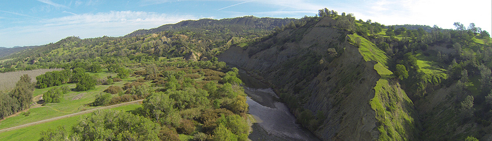
Burro Creek
 Burro Creek (red on the map here) is a typical desert mountain water course. Nestled in rocky canyons, it drains the area north of Bagdad, AZ. Its multiple tributaries come together a few miles upstream from where it crosses Route 93.
At the crossing, there’s a beautiful steel arch bridge. The original bridge was built in 1966, but a duplicate bridge was built beside it just a few years ago when the road was widened and extra lanes were added (see photo below). The canyon there is deep on both sides, then drops off on the south side where BLM has put in a campground.

After the campground, the canyon walls climb on both sides as the creek winds through some mountains. That’s where Kaiser/Warm Spring Canyon (blue on the map) joins it. They continue the course as Burro Creek about 8 to 10 miles where Burro Creek joins the Big Sandy River (green on the map). From there, the Big Sandy River continues through flat land and then more mountains.
The Santa Maria River (orange on the map) joins them just before they all spill into Alamo Lake, which sits at the bottom of a broad, relatively flat valley, with mountains on its north side. What comes out of Alamo Lake, past the dam, is called the Bill Williams River, which eventually spills into the Colorado River.
Burro Creek usually has some water in it. Pools form under the bridge and then in the canyon just before the Kaiser Canyon confluence. In most cases, the water is a trickle between these pools that dries up before Kaiser Canyon.
Kaiser Canyon, which is also known as Warm Spring Canyon because of a hot spring at the bottom of the canyon, is normally dry, except for where the spring is. Upstream, it’s an interesting hike though a narrow slot canyon. I would not want to be there during a heavy rain.
The Big Sandy River is a lot like the Hassayampa, which flows through Wickenburg. It’s mostly sandy riverbed with water flowing underneath, but when there’s heavy rain, it flows. The Santa Maria is more likely to flow than the Big Sandy, but most of its course is through canyon areas just south of the Arrastra Wilderness, passing between the Poachie Range and the Black Mountains.
Yesterday, of course, Burro Creek, the Big Sandy River, and the Santa Maria River were all running at low flood stage. It had rained all day the day before and most of the night before. The heavy rain, winds, and flood waters had destroyed my client’s drilling camp and washed away the materials we were looking for.
So I started my flight for them with a few circuits around their camp at the bottom of the Burro Creek Canyon. I couldn’t get beneath the canyon walls because it was very windy, very turbulent, and very narrow. But I showed them enough for them to get a sense of the damage done and possibly find some other equipment that may or may not have been lost. They took pictures, of course, so they could share what they’d seen with their crew.
From there, we headed down Burro Creek. The water flowed beneath us in a silt-filled torrent, tumbling over boulders in the stream bed and crashing into canyon walls at sharp turns. I could imagine a kayaker down there, paddling to find the best course, getting covered with cold, fine sand. Ick. I could also imagine the lost equipment floating along in the current, racing downstream.
When the canyon ended, I was able to drop down closer to the water. The Big Sandy added its water to the flow and the river spread wide. We were flying into the sun and fighting against its glare to see. We didn’t see the lost items, although there were plenty of places on either side of the river where it could have been caught in trees, weeds, etc.
We reached the place where Signal Road meets Seventeen Mile Road. There are a few houses there and three places where wires cross the river. I wasn’t low enough for them to be a problem, but I liked being able to see them.
The river forked to two paths near there and my client told me to take the larger path. We continued downriver, searching. Then the river entered another canyon area and I had to climb a bit. One spot was turbulent enough to knock us sideways, but I straightened us out and continued. No sign of the equipment we were looking for.
At this point, I began to feel bad for my clients. They were paying me $495/hour to help them find this equipment and we weren’t having much luck. They were already into it for at least an hour to cover my time to get to them and back to Wickenburg. Before we were done, I’d have cost them over $1,000. I really wanted to help them find something.
But as we continued downstream, it looked less and less likely that we’d succeed.
Finally, we emerged from the last canyon where the Santa Maria River joined the flow. Alamo Lake was ahead of us. Normally a clear blue body of water, it was stained brown with silt and floating debris where the rivers joined it. A fishing boat was picking its way through the debris with two men on board. There was no sign of the missing equipment floating on the lake.
I turned around and we headed back upstream. Now the sun was at our back and it was a lot easier to see what we were flying over. We could clearly see wet and dry spots on the wide river bed. Wet spots are where the equipment could be; dry spots were not. Since I knew exactly where all the wires were, I was able to drop down closer to the water surface. We followed the course of the river upstream winding through the canyons and back into the wide, flat area just downstream from the Big Sandy’s confluence.
When we reached the spot that the river had split, I suggested that we try the other fork. They agreed. So I followed that upstream.
We were just downstream from the split when I spotted it: a black barrel with a white label on it. I pointed it out. “Is that one of them?”
They looked. “Yeah, it is. Good eyes.”
We came down for a closer look. It was a 55-gallon metal drum beached on the island between the two river courses. My clients wanted me to land, but there was no truly safe place to do so — the island was a mix of fine sand and large, round river rocks, with no level spots nearby. So I hovered right up to it. We looked at it together and my client took photos. The barrel looked as if it had been over Niagara Falls. Fortunately, there was a road and those homes not far from where we’d found it. When the water receded a bit, it would be easy to recover.
We continued upstream, looking for another barrel just like it. We circled around a few times, but didn’t have much luck. A few minutes later, we were back at the canyon. The wind was howling and I had to climb. We had a close call with a bird that all three of us saw fly past under the helicopter’s bubble. We circled around the ruined camp again and they took more photos. They wanted me to descend into the canyon, but it would not have been safe and I told them so. Instead, we climbed out, back to the LZ. We had a bit of help from a powerful updraft.
“Feel that?” I said as the vertical speed indicator hit 800 feet per minute.
They both did.
“I’m not doing it,” I told them. And I think they got an idea of what it might have been like fighting the wind in that narrow canyon.
I set down at the Landing Zone and they gathered their things together. I told them I’d send them a copy of their receipt; I already had a credit card to charge for the flight. They got out and walked back to their truck. I checked their doors, then plugged my iPod back in and started it up. Then I took off in a climbing right turn back toward Wickenburg.
The Flight Back
I had a headwind all the way back and couldn’t get a groundspeed above 100 knots. I went the most direct route I could, but did make sure I overflew the Barnes Ranch on the Santa Maria River. Eric Barnes has a landing strip there with a taildragger he uses to come to Wickenburg, where he keeps a car. But the river had cut off the ranch from the road. I made a few calls down to them on 122.9 — that’s the frequency they monitor at home — offering to take them into town. But I got no answer, so I continued without stopping.
The turbulence I was flying in faded when I got out of the mountainous area. But by the time I got to Wickenburg, the FBO guy was telling landing traffic that the wind was 20 miles per hour from 140 degrees. That’s a direct crosswind at Wickenburg. Three planes were in the area — all student pilots with instructors — and I made appropriate calls so they’d know where I was. I landed from the northwest, directly into the wind, across the runway to the ramp. It’s nice to be a helicopter.
Total time for the flight: 2.3 hours.

 Maybe I’m not very creative, but my avatar is a photo of me. It was taken by photographer
  Burro Creek (red on the map here) is a typical desert mountain water course. Nestled in rocky canyons, it drains the area north of Bagdad, AZ. Its multiple tributaries come together a few miles upstream from where it crosses Route 93.