A Tale of Two Helicopter Operators

And why neither got my business.

We were in Glacier National Park last weekend. It was our first visit. Glacier is an amazing place, full of granite mountains, lakes, rivers, and waterfalls. It’s the kind of place that’s perfect to explore by helicopter.

There are two helicopter operators in West Glacier, right outside the park. Here’s our experience with them.

Mom-and-Pop

The first one you come to as you’re driving in from the west is the “mom and pop” operation my friend, Jim, had recommended. Jim operates Big Country Helicopters in Coeur d’Alene, ID and had worked with this particular operator to give one of his clients a helicopter flight over the park. This operator has just one helicopter, a Bell Jet Ranger, which seats 4 passengers. It’s the perfect size helicopter for the location — two couples or a family of four can fly together but it’s likely to be cost-effective enough to take just two passengers. I assumed that like most smaller tour operators, this operator was more likely to offer a personalized tour experience.

Unfortunately, when we stopped in to the office for this operator at about 5:10 PM on a Saturday afternoon, the office was closed. There was no sign on the door with hours or a phone number. There were no brochures to take away. There was nothing. It was as if they weren’t interested in doing any business. Oddly, there were two vehicles and the helicopter parked at the property. But no one was around to help us or even tell us where we might be able to get help.

As they say in Twitterland: #FAIL.

The Big Operator

The other operator in West Glacier flies Bell Long Rangers — the same helicopter I flew at the Grand Canyon back in 2004. These helicopters seat six passengers, but two face backwards. I’ve sat in one of those backwards-facing seats and I can tell you that it sucks. This operator had three helicopters, one of which was parked right alongside the road on a little hill — kind of like a car dealer might show off a car or truck to passersby. There was some activity by one of the helicopters; some park employees in uniform and a pilot in a flight suit scurrying around like they were prepping for a flight. No tourists around, though.

A sign on the door said they were open from 8 AM to 8 PM. We went inside. A woman greeted us before we could get to the counter. The conversation went something like this:

Woman: “Can I help you?”

Me: “We’re interested in a helicopter flight.”

Woman: “Well, we’re done for today. Do you want to book something for tomorrow?”

Me: “Well, can you tell us about the flights? Where do they go?”

Woman: “There’s a half hour flight for $110 per person and a one-hour flight for $220 per person. There’s another couple going out on a 9 AM flight tomorrow. I can book you on that.”

Me: “We’re leaving tomorrow morning. We’ll think about it.”

I didn’t have much to think about. The woman had lost my business by making three mistakes:

  • If your sign says you’re open until 8 PM, don’t tell potential customers that you’re “done for the day” at 5:15 PM.
  • If your customer asks a question, answer it. Don’t answer questions that aren’t asked until after you’ve answered the one that was. I didn’t ask how long the flights were or what they cost. I asked where they went. I expected to see some kind of map of the park with a flight route.
  • Ask your customers what time is convenient for them. Don’t try to put them into a time slot that’s convenient for you.

Her attitude was so typical of the big helicopter operators. They can save it for the tourists who don’t know better. I worked for an operation like that and I won’t subject myself to their type of “service.”

No Helicopter Tour of Glacier National Park

So we didn’t get to see Glacier from the air. That doesn’t mean I won’t. I’ll be checking into the rules and regulations for flying over the park. Maybe next year, on our way to Washington, we’ll take a northern route.

Wenatchee to Walla Walla to Lewiston to Coeur d’Alene

On the road again.

Those of you who read this blog regularly, may have begun wondering why I’m not posting as regularly as usual. The truth of the matter is that I’m traveling, on a long road trip from Washington State to Arizona.

We’re doing the trip at a leisurely pace, with stops 100 to 250 miles apart. No rush; our friend John is watching over our place. (Hi, John!)

Wenatchee to Walla Walla

Our first leg was mostly in the farmland of Central Washington, ending up in the wheat- and wine-growing area of Walla Walla. Walla Walla has special significance to me; twice it was listed as one of the top ten places I should live by FindYourSpot.com.

Ghost Photo

Some places just scream to be photographed at night. (Hey, is that a ghost?)

We spent two nights in the Four Seasons RV Resort, which I rate 4 out of 5 stars. (Partially wooded and relatively quiet, park-like setting with tall trees and shade, pet friendly, washer/dryers, limited WiFI, affordable.) During the day, we explored Walla Walla, ate in great restaurants (I recommend Saffron Mediterranean Kitchen), visited wineries, and went out on the bike trail. In the evening, we did a little photo shoot of this weird spot at the back of the RV park property.

Walla Walla to Lewiston

It was just 100 miles or so to Lewiston, ID. We drove on route 12, which wound through small farm towns and wheat fields. It’s mostly past harvest now, so the fields were left with short-cut tan stalks of wheat or plowed brown dirt.

After the Sun

View from our campsite. Not too shabby, huh?

In Lewiston, we stayed at Hell’s Gate State Park, which I rate 5 out of 5. (Wooded, riverfront sites with full or partial RV hookups, beach, bike trail.) The idea was to hop on a jet boat tour down Hell’s Canyon, but we soon discovered that all day trips are 11 hours long and half-day trips don’t run regularly. Since Lewiston isn’t exactly our idea of a great destination, we only stayed one night.

Lewiston to Coeur d’Alene

We drove up to Coeur d’Alene on route 95, which winds through some of the prettiest rolling hills and wheat fields you could imagine. We had a little adventure when we pulled off the main road in search of a picnic lunch site and found ourselves, pulling our trailer, on a narrow dirt road used by large trucks for some unknown (to us) purpose. We got about 3 miles down the road, trailed closely by a very large truck, before we found a place to turn around. We wound up having lunch at a cafe in Plummer, ID. Can’t say I recommend it, although the peach pie was good.

Dropping in at Cabella's

Jim took us to lunch at Cabella’s. (Pardon the crappy quality of this cell phone photo.)

In Coeur d’Alene, we camped at the Blackwell Island RV Park, which I rate 2 out of 5. (Full sun on all sites, closely packed sites, gravel driveways not long enough for rigs, a list of rules longer than my arm, sporadic WiFi, riverfront location, expensive.) After exploring a beautiful and vibrant downtown area, we met up with my friend Jim and his wife, Teresa for dinner at 315 in the Greenbriar Inn. Jim runs a helicopter charter business remarkably similar to mine. On Wednesday, he took us for a helicopter tour of the area that included landing at Cabellas at State Line for lunch. I spent the evening catching up on some work while Mike went swimming in the Spokane River with Jack the dog.

Coeur d’Alene to Glacier National Park?

Well, that’s the plan, anyway. We hope to be on the road by 8 AM. More later.

Light Matters

Two shots prove it.

We spent Monday night camped out along the east shore of the Snake River in Hell’s Gate State Park, just south of Lewiston, ID. The river is held back by a dam downstream to form a long, meandering lake that has plenty of boat traffic, including the “jet boats” that take people upriver through Hell’s Canyon. All that traffic makes for rough water, but I reasoned that early in the morning, around dawn, the water could be pretty calm. With first light on the gold-colored hills across the river from our campsite, I might be able to photograph some interesting reflections without a lot of effort.

While the idea of waking before dawn to take a few photos might seem like a chore to some folks, it isn’t usually a big deal to me. I’m usually awake by 6 AM anyway, and that was certainly the case on Tuesday morning. So I threw on some clothes, grabbed my camera and tripod, and went out along the path behind the camper to see what I could shoot.

What I ended up with was a great example of how the quality and color of light can change a photo.

Before the Sun

This first shot reveals an interesting scene in gray light. Photo details: 1/50 sec, f4.8, ISO 200, 35mm

I set up and framed my shot. The reflections were as good as I’d hoped and the shots achieved the almost mirror-like look of land reflected on water. But the light wasn’t quite right for the first bunch of shots. Even after the sun rose, it failed to cast its rays on the scene before me. For a while, it was the high hills behind me, to the east, that kept the sunlight off my scene. Then it was a cloud. The light was gray and colorless.

After the Sun

This shot was taken a minute later, when the cloud had moved away, revealing the sun. Photo details: 1/80 sec, f4.8, ISO 200, 35mm

Then, suddenly, the cloud slipped away and the low sun shone directly on the scene before me. It lit up with a golden glow and I snapped another photo. This shot was taken exactly one minute after the previous one. Rather than slowly creep down the scene to illuminate it, the sun shined full on the scene, all at once.

It wasn’t until I reviewed these two shots in quick succession in my camera that I noticed the dramatic difference you see here. These images were not manipulated in any way in an image editing program other than to downsize them for the Web. I think they speak for themselves as they are.

I’ve read a lot about photography, especially in the past year or so. One of the things I read recently was a “tip” by a photographer who basically said not to bother shooting in bad light. These two photos do a pretty good job of explaining why light is so important. And while I won’t tell anyone not to shoot in bad light, I hope these photos help them understand how light can make a difference in their photography.

Leaving Wenatchee

Nine weeks was enough.

On Saturday, we left Wenatchee. I’d been in the area — Quincy and Wenatchee, WA — since June 8 and was really ready to go. But there were a few things that needed doing before we could go.

A Day in Seattle

First I had to meet up with my husband. He’ll be joining me for our return drive to the Phoenix area. He flew up from Phoenix to Seattle on Alaska Airlines with some luggage, his bicycle, and Alex the Dog. His flight was scheduled to arrive at 9:30 AM Thursday, so at 6 AM that morning, I was in the truck, driving west to meet him. We had a nice reunion at baggage claim carousel 14, where Jack was very surprised to see me waiting for him when they rolled in his new travel crate.

SR-71

SR-71 on display at the Museum of Flight in Seattle, WA.

Not to waste a day in Seattle, we had breakfast at 13 Coins near the airport and then headed over to Boeing Field for a visit to the Museum of Flight. We spent a few hours there, enjoying the exhibits. It’s a great aviation museum with something of interest to people of all ages.

Afterward, we went to Mike’s cousin’s house in the northern part of Seattle, not far from the University of Washington. Mike’s cousin Rick and his friend Lisa live in a tall, narrow house on a quiet residential street. We went for dinner at a nearby Italian restaurant, where were were joined by my friend, Tom, who I hadn’t seen in about 15 years. Tom, who lives in Vermont, was in the Seattle area on business and we managed to plan our day in Seattle for the same day Tom had some free time. It was great to see him.

Afterwards, we drove back to Wenatchee along scenic Route 2. Unfortunately, we left too late in the day to see anything; it was dark long before we reached the pass. It was also a bit foggy. I’d love to drive this route on a nice day. I flew it in June with my Twitter friend, @Jodene, and it was incredible.

Moving the Helicopter

The idea was to fly the helicopter back that way the next day. I’d booked tickets for Mike and me on Horizon from Seattle to Wenatchee on Friday’s 4 PM flight. The plan was to spend Friday morning moving the trailer from where it was parked in a Wenatchee Heights orchard back down to Wenatchee, where we’d get one of its tires replaced. Then we’d fly the helicopter to Boeing Field, where one of my mechanics is based. Then we’d catch that 4 PM flight back to Wenatchee, finish packing up, and be out of the area by Saturday morning.

The weather didn’t cooperate. It had been almost rain-free all summer, but it poured like hell on Friday in Wenatchee. The storm came from the north and moved slowly to the southeast. We managed to stay on schedule to fetch the trailer and get its tire changed, but when we were ready to take the helicopter to Seattle, a thick blanket of clouds clogged both mountain passes — Snoqualmie (I-90) and Stevens (Route 2). There would be no flight that day.

It was unfortunate because, as Seinfeld’s Kramer might say: in my mind, I was already gone.

The next day, I was awake at 6 AM. It was a beautiful, clear, sunny morning. If we could get our act together quickly, we could fly to Seattle and catch the 9:55 flight back to Wenatchee. Otherwise, we’d have to wait until 4 PM. After checking the weather as well as I could, I decided to go for it.

We were airborne by 7 AM. I climbed out with a direct-to Cle Elum on my GPS, requiring a 500-800 fpm climb rate for the first 5 minutes of the flight to clear the mountains. As we climbed, we could see the tops of clouds out in the mountains in the distance ahead of us. I was hoping that those cloud tops were for a shallow band of clouds and that there would be room beneath them for us to fly over the highway through Snoqualmie Pass.

We descended over Cle Elem and hooked up with I-90. Soon we were flying under the cloud bank with plenty of space between us and both the ground and the clouds. But as the terrain rose toward the pass, the clouds descended. We passed Easton and things began to get uncertain. Just short of the pass, we realized that the clouds came right down to the ground. There was no safe way through.

I turned around and headed back toward the edge of the cloud bank. There were plenty of tempting holes in the clouds where I could have passed through to fly above them. But I don’t like flying atop a bank of clouds. Eventually, you have to come back down, and if there’s no hole on the other end, you’re stuck up there. I did not want to put myself into that situation.

Mt. Rainier

Mike took this shot as we approached Mt. Rainier. You can see a little bit of the cloud cover around its base.

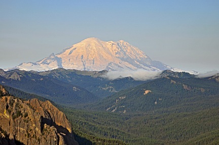
We reached the edge of the cloud bank and turned to the south. We climbed and were soon above the level of the clouds. Mt. Rainier was poking out of the top of the cloud bank, but there was plenty of clear, cloud-free space around its base. We headed that way. Beneath us, several deep valleys were full of cottony clouds, as if stuffed by some well-meaning giant. Ahead of us, Mt. Rainier rose tall and proud and snow-covered out of the rocky terrain. Grassy slopes of its foothhills glowed bright green with thick grass, speckled with tall pines and granite outcroppings. The views were incredible.

Unfortunately, I was too concerned with our flight path to enjoy the view. I needed to get under the clouds in a valley that sloped downward toward Seattle. I needed to do that without actually flying through any clouds. My first instinct was to find a road, since most roads lead to a pass. But some roads climb, descend, and climb again. Any of the climbs could take the road into the clouds. I soon realized that a mountain stream or river would be better.

We found just the one we needed on the northwest side of Rainier. I descended at 2,000 fpm at the edge of the cloud bank, ducking under it with plenty of room to spare over the riverbed. We followed it closely, winding back and forth, keeping an eye out for wires. Finally, the canyon opened up and we could see homes and towns in front of us. A while later, the skyline came into view on a typically gloomy Seattle day. We touched down at Boeing Field at about 8:45 AM. We’d logged 1.6 hours of Hobbs time on a flight that should have taken 45 minutes.

You can see our entire flight path on the chart here:

Our Flight Path

But the bigger miracle was that we caught a cab to SeaTac and were sitting on the Wenatchee-bound plane less than an hour later. By 10:30 AM, we were on the ground in Wenatchee.

By 3 PM, we were packed up and on the road, headed for Walla Walla. But that’s another part of the story.

Food for Thought for American Conservatives

More good content floating around the Web.

This morning, @derekcbart tweeted a link to a site with the below-quoted content. I’m trying to find the source and the closest I seem to get is this post on reddit.

The author of this put a lot of thought into it. Although his grammar leaves a bit to be desired, and his original title is sure to turn off anyone who actually is a conservative (which is why I edited it), he’s 100% correct in his statements. I’m reposting it here as some food for thought. (If you are the author of this post and would like it removed or would like attribution, please contact me.)

I AM AN AMERICAN CONSERVATIVE [REDACTED]

this morning I was awoken by my alarm clock powered by electricity generated by the public power monopoly regulated by the US department of energy. I then took a shower in the clean water provided by the municipal water utility. After that, I turned on the TV to one of the FCC regulated channels to see what the national weather service of the national oceanographic and atmospheric administration determined the weather was going to be like using satellites designed, built, and launched by the national aeronautics and space administration. I watched this while eating my breakfast of US department of agriculture inspected food and taking the drugs which have been determined as safe by the food and drug administration.

At the appropriate time as regulated by the US congress and kept accurate by the national institute of standards and technology and the US naval observatory, I get into my national highway traffic safety administration approved automobile and set out to work on the roads build by the local, state, and federal departments of transportation, possibly stopping to purchase additional fuel of a quality level determined by the environmental protection agency, using legal tender issed by the federal reserve bank. On the way out the door I deposit any mail I have to be sent out via the US postal service and drop the kids off at the public school.

After spending another day not being maimed or killed at work thanks to the workplace regulations imposed by the department of labor and the occupational safety and health administration, enjoying another two meals which again do not kill me because of the USDA, I drive my NHTSA car back home on the DOT roads, to ny house which has not burned down in my absence because of the state and local building codes and fire marshal’s inspection, and which has not been plundered of all it’s valuables thanks to the local police department.

I then log on to the internet which was developed by the defense advanced research projects administration and post on freerepublic.com and fox news forums about how SOCIALISM in medicine is BAD because the government can’t do anything right.

As an American with empathy for those struggling against the odds to survive in financial hard times, I think health care reform will provide relief to many, many people. Please understand that the reform proposed by the Obama administration is nothing like the socialized medicine the NeoCons want you to think it is.

And if anyone knows the real source of this passage, please use the comments to share it. Do not use the comments to share untruths meant to scare the public; they will not appear on this blog.