RV Living

A quick look at my current RV living experience.

I’m back in Quincy, WA for the third consecutive year, gearing up for cherry drying season. On Saturday, when my first contract starts, I’ll be literally stuck here in town, waiting for it to rain so I can spring into action and fly for my clients. And if the weather stays the way it has been for the past week, I’ll be doing an awful lot of flying.

The previous two years, I lived in a 22-foot “hybrid” RV that included a hard-sided camper shell with a single slide out and two pop-up camper type beds. When I first bought this camper, I thought it would be perfect for this kind of mission. But I didn’t foresee the need to write three books in it or an excruciating back problem that would last a month. I realized that when you have to live in an RV for three to four months out of the year — with a parrot, no less — you’d better have a pretty damn comfortable RV.

So I bought what I considered to be “the perfect RV.” While I don’t really think it’s “perfect,” I still believe that it’s as close as I’m likely to get unless I have one built to my exact specifications — which is not an option. This RV has plenty of space, as well as comfortable places to sit. Best of all, I don’t have to work in the same space where I try to take my meals.

But I’m getting ahead of myself here. @Miraz wanted to know more about my setup here, so let me go into that a bit.

The Campground

I’m living at the Colockum Ridge Golf Course. A weird thing about golf courses out here is that they often include a limited number of RV parking spaces. Colockum Ridge (formerly Quincy Golf Course), which is now owned and operated by the Port of Quincy, is one of those places. It has five or six full hookup sites — that means sites with water, electricity, and sewer hookups. The sites are not far from the main office, between a wide driveway area and a narrow path out to the golf course. One of the greens is about 50 yards from the last spot. The golf course also has a handful of water and electric only spots. Those are on the other side of the wide driveway, near a well-trafficked road.

For the first two years I was here, the monthly rate for a full hookup spot was $300. I thought that was a pretty good deal. The first year, all the full hookup spots were occupied by me and construction workers for a pair of data centers being built in Quincy. Last year, I was the only long term occupant. This year, in an effort to attract more long term occupants, they dropped the monthly rate to only $200. This is a steal. (Oddly, I was worried the rate might go up; never expected it to go down.) The only drawback to the lower rate is that they’ve apparently attracted the owner of a junky old trailer who seems to be using his site as a weekend getaway. (Sometimes a higher rate is good to keep the riffraff out.)

My RVAlthough the spots are small, they do have well-kept lawns. Parking is on a gravel spot that you need to back into; that gravel area is surrounded by railroad ties on three sides to keep it separate from the grass. The spots aren’t exactly level — as I found out this year — but they’re not far off. I surprised myself with my ability to get the trailer into the spot; it was the first time I’d every done any serious backing up and it didn’t take more than a few tries to get it into place.

There are a few drawbacks of living here:

  • They start tending to the grass not long after dawn. That means there are lawn mowers running as early as 5:30 AM. This doesn’t bother me because I’m usually awake by then.
  • Because the RV spots are near the office and the office is at the intersection of two major roads, traffic noise — especially trucks slowing down to make one of the stop signs — can be a bother. In my old camper, it actually kept me up at night. In my new one, I don’t hear much unless the windows are open.
  • Golf carts and the odd piece of maintenance equipment drive right past the back window of my RV all day long every day. Before I moved the trailer 2 feet forward to get the left wheels on blocks (for leveling), they’d be within arm’s reach of my back window. Now they’re 2 feet farther away.
  • The sites really are tiny — although I suppose they’re about the same as the standard RV parking lots selling themselves as RV parks or “campgrounds” these days. My front slide-out actually hangs over into the parking spot next to mine, which is on a weird angle. There’s nothing I can do about it.

But there’s plenty good about living here:

  • They allow me to have my mail delivered to their address. So I can get mail and packages delivered to me here. I’m also the one who collects the mail daily; apparently no one else ever checks it. The first time I checked it, the box was absolutely stuffed. The mail carrier must like me.
  • This year, I have a picnic table, which will come in handy (if it ever stops raining for more than a few hours) for using my new barbecue grill, eating out, and getting Alex the bird outside for a while.
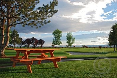
  • After the RainI have some nice views. My “office” window looks out on an idyllic view of trees, a picnic table, and the golf course. There are also birds — primarily robins — digging in the grass for worms throughout the day. Soon they’ll bring their chicks.
  • My helicopter is parked at an ag strip right across the street. In fact, I can see it from my back window. That means I can hang out here until I’m called out to dry. Definitely beats sitting in the truck at an airport for hours, waiting for a call that might not come. An added bonus: watching the crop dusters fly by.
  • I can get wireless Internet that works just well enough to pay for it. (I’d be very happy if it worked reliably all the time.)
  • The golf course has a restaurant where I can get breakfast or lunch if I get too lazy to cook. It’s not a great restaurant, but I’m not complaining.
  • The golf course is only five miles from town, where there’s a supermarket, coin-op laundry, post office, and other conveniences.
  • The area, being a farming community, is relatively safe and secure, so I don’t have to worry about my personal safety or the security of my belongings. It’s unlikely, for example, that anyone will break into my truck or trailer or walk off with my barbecue grill.
  • The golf course is in the middle of a farmland grid, offering lots of easy bicycling for me to get exercise.
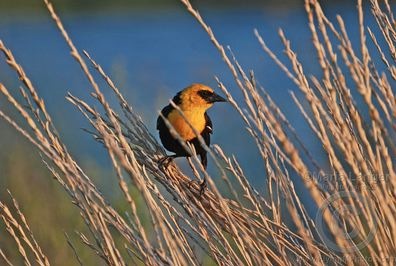
  • Yellow-Headed BlackbirdThe golf course is only a few miles away from the Quincy Lakes area, which offers hiking, fishing, camping, and wildlife photography opportunities. Over the past two years, I spent a lot of time with my camera at Quincy Lakes, photographing birds.

The more I stay here, the more I like it. I’m even thinking of blowing off an aerial photo gig in Nevada in August so I can spend another month here.

The RV

The RV is amazingly comfortable. Comparing it to my old RV is almost silly, but here are a few examples:

  • There is a ton of storage. Enough storage to put everything away and still have space for more. That includes inside storage for indoor things and underneath storage for outdoor things. I even have enough room to store the old muffler for my helicopter, which I need to get repaired so it’s available as a spare. (They cost $2K new.)
  • The kitchen area has counter space for my coffee maker and grinder and enough cabinet space to store all my food, pots and pans, and dishes. And it even has drawers for storing silverware, napkins, and utensils. The stove is self-lighting so I don’t need to have a lighter or matches handy all the time to use it. The sink is a decent size, too.
  • The table and chairs is a hell of a lot more comfortable than the booth I had in the old camper. And with lots of windows, its bright and airy.
  • The sofa may not be as comfortable as the one in front of our TV at home (which is the most comfortable sofa in the world), but it sure beats the sofa in our last trailer. And rather than covert into a short, narrow “bed” for guests, this one has a queen-sized air mattress that two can sleep on comfortably.
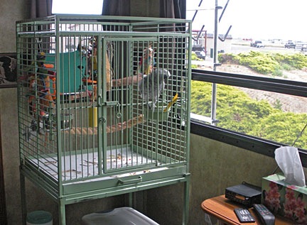
  • Alex's Cage in my RVThere’s a La-Z-Boy style rocker/recliner. (There were actually two, but we pulled one out to have room for Alex the Bird’s cage.) I never thought I’d like one, but I spend a lot of time in it. I sit here and blog or read in the morning with my coffee and sometimes do the same after I’ve covered Alex for the night. It’s right beside the big back window, so I can watch the world — or at least this part of it — go by.
  • The RV has not one, but two flat panel televisions. They’re kind of wasted on me — I don’t watch much TV so I don’t have a satellite receiver. But I can pick up about 6 channels, including Fox and PBS. The 32-inch TV in the main room has a DVD player, so I can watch my Netflix videos on something larger than my computer monitor.
  • My RV OfficeI have an “office.” It’s a slide out with a desk and room for a chair. I’ve got drawers and cabinets to store my office stuff, so there’s not a lot of junk lying around. I brought along my 24″ iMac so I have all the same computing capabilities I have at home. And I managed to bring my color laser printer (what was I thinking?) and store it out of sight in a cabinet. There’s even a spot for my scanner. The office area even has two windows that look out over the golf course.
  • The bedroom has a nice bed with a dresser and closet. So I can store all my clothes neatly and accessibly. There’s a window on either side of the bed. I can even walk around the bed. The only thing I wish it had was a night table or storage area for the kinds of things you like to keep beside you at night. (And yes, I will be buying a new mattress for it; the mattress it came with is a real piece of crap. Just not sure how I’m going to get it through the doorway by myself.)
  • The shower has enough hot water for me to take a shower without turning off the water during the wash cycle. Yes, I can bask under hot water for the entire time I’m in the shower. Like a normal person. In my old RV, it was typical to run out of hot water during a shower; in fact, when I camped at a campground with a shower facility, I used their shower. Those days are over.
  • The toilet has a food pedal for flushing. The old trailer had a hand lever. That meant I needed to bend over the toilet every time I wanted to flush. Gross. It’s simple things like this that really make a difference in your life.

So I’m not exactly suffering out here in Quincy, WA. Sure, it’s not as nice as the house my buddy Jim rented in Chelan last season when he had contracts up there, but it’s very pleasant. And unlike Jim, I don’t have to share my space with another pilot — or anyone else other than Alex the Bird.

In a way, it’s a bad thing that the RV is so comfortable and pleasant to live in. Combined with my relatively pleasant surroundings and cheap living costs, I feel that I’d rather stay here than go home. I never felt that way in the old RV — especially when the temperature started rising and the horrendously loud air conditioning couldn’t keep up. This is my home away from home and I’m really enjoying it.

My Electric Blanket

A “blankie” for a grown woman?

Back in the winter of 1977, when I was 15 years old, my family relocated from northern New Jersey to Long Island, NY. We went from an old house built in 1901 to a much more modern home built in the late 1960s. But best of all, for the first time in my life, I had my own room.

Our arrival in Long Island was about a year before the energy crisis that would strike the country. To save energy (and money) — the house was heated with an oil furnace — my stepdad fitted the house with set-back thermostats that would automatically drop the heat to 62°F at night. To make sure we were all warm and comfy at night, my sister, brother, and I were issued electric blankets.

Clash of the Technologies

Clash of the technologies: the control for my 32-year-old electric blanket seems slightly out of place in this digital world.

If you’re not familiar with electric blankets, here’s how they work — or at least my understanding of them. They’re made with two layers of a synthetic fabric with a series of wires running up and down between the two layers. I assume the wires have some kind of heat emitting properties. At the bottom end is a socket for a plug. A control device plugs into the socket with a long wire — the idea is to put the control on your bedside table, so the wire is at least as long as a bed. Another wire plugs into a wall outlet. When you get into bed, you turn the blanket on and use the control to dial in a setting.

It must have worked, because I don’t recall being uncomfortable on cold winter nights — except, of course, those nights after an ice storm knocked out power for 11 days.

A few years later, when I moved onto my college campus, I brought the blanket with me. And I brought it with me when I got my first apartment. And when I moved into a new apartment with my future husband. And when we moved into our first house. And when we moved into our second house. And when I began spending summers in an RV in Central Washington State.

The blanket, which is now 32 years old, is with me on this trip. And I’m glad to have it.

When I first arrive in Quincy Washington at the end of May, it’s downright cold at night. RVs have three problems when it comes to heat:

  • They are generally poorly insulated so they can’t hold heat well. This RV is much better than my previous one, which had two tent walls.
  • Their heaters are unbelievably loud, consisting of a gas furnace and a loud blower that attempts to shoot hot air throughout the space.
  • Their heaters don’t evenly heat the space. Face it: what heater does?

The first season I was here in my old RV, I slept under a pile of blankets. No exaggeration — my first few weeks were spent on flannel sheets under every single blanket I’d brought with me. It was like sleeping between two mattresses. I still had to wear flannel pajama pants to keep warm.

I got a case of the smarts the next year and brought the old electric blanket with me. That made all the difference in the world.

Now all the instructions that come with these blankets tell you to make the blanket the top layer. But I usually sandwich the blanket between my top sheet and a lightweight comforter. As a result, I can set the blanket to “1” or “2” (on dial that goes to 10) and keep very warm.

The blanket is for a twin size bed and my bed in the RV is a queen. But the blanket covers the top pretty well. It makes for very cozy sleeping.

My big problem now is getting out of that nice warm bed in the morning.

Joy-Flying on a Saturday Afternoon

It’s days like this when I feel very privileged.

I spent most of yesterday morning at my desk, editing videos I recorded the previous afternoon. It was boring, tedious work, made even more unpleasant by a stupid little nagging headache I’d had for more than 24 hours. In general, I was feeling under the weather and I couldn’t understand why. It was a nice day and I had most of the windows in my RV open for fresh air. Even Alex the Bird was behaving.

I worked on a book for a while, then decided I needed a break. I’d head into town and pick up a few groceries, along with an ice cream sundae. That would make me feel better.

The supermarket parking lot was unusually crowded. That’s when I realized it was Memorial Day Weekend. (One of the oddities of being a freelancer is being completely oblivious to things like weekends and holidays.) The parking lot was crowded and so was the store. I realized that many of the people shopping for their holiday weekend groceries were young people who were likely camped out at Crescent Bar.


View Quincy, WA in a larger map

Crescent Bar is a mostly manmade island extending down along the Columbia River just before it enters a gorge. There’s a campground, a few trailer parks, some condos, a golf course, boat ramps, and a cherry orchard (belonging to one of my clients) down there. On weekends, it’s a popular destination for water lovers.

Seeing these people filling their shopping carts with chips and salsa and hamburger buns gave me a brainstorm. Why not take a little flight down to the river and around Quincy Lakes? And maybe even past the Gorge Amphitheater? Hell, I was a helicopter pilot. I had a helicopter parked at an ag strip within sight of my RV. Why the hell wasn’t I flying it?

(For the record, one reason I wasn’t flying it is because it costs a fortune to fly and I’m not made of money — although too many people think I am. Still, occasionally I do need to treat myself to a flight that doesn’t have a “mission” attached to it. Today would be that day.)

So I drove back the RV, stowed my groceries, and hopped back in the truck. A while later, I was standing on the truck’s bed, gently pulling off the blade covers. After a quick preflight, I climbed on board, and started the engine. I did some paperwork while everything was warming up. Then I donned my headset, waved to the ag pilots who were hanging out by the office door, and took off.

Where I live in Quincy is a good 700 feet higher in elevation than the Columbia River. The river flows in a gorge carved out by massive ice age flooding. Quincy sits on a sort of shelf full of irrigated farmland; there’s another, higher shelf to the north covered with wheat fields. The area is fascinating from a geologic perspective. You can really appreciate it when you fly over and through it in a helicopter — which I’d done numerous times in the past two years. I like flying along the towering basalt cliffs and over the various formations formed by those floods.

I hooked up with the road and descended with it through a valley that dropped in steps down to the river. I was cruising at 110 knots. I slipped over the final step and descended down to about 200 feet over the river. There were lots of boats and jet skis speeding around. The campground was full. I circled a small island where some people were camped out, then sped off downriver.

Crescent Bar

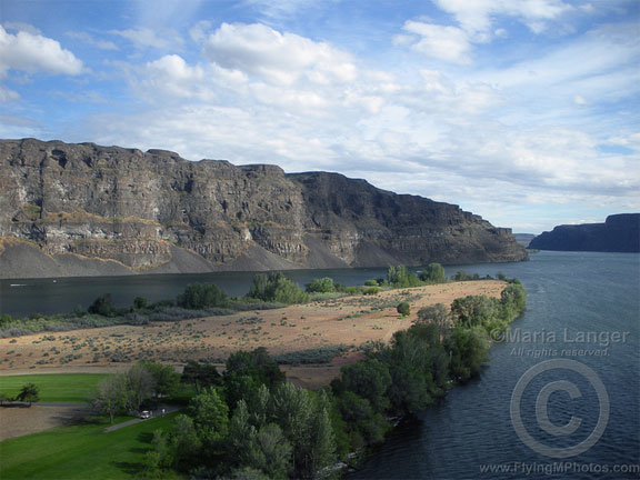
I snapped this photo of the south end of Crescent Bar as I left the area. Quincy’s farmland is spread out on the shelf above the cliffs on the left side of this photo. (View a larger version in my photo gallery.)

Farther downriver, I swung to the east and climbed over the edge of the gorge. I sped over Dusty Lake, where Mike and I had gone hiking with Mike’s cousin Rick and his friend last year. A few fishermen stood on the southwest side of the lake and looked up at me as I zipped past. Then, dodging wires, I climbed back up to Quincy’s level and headed southwest. The Gorge Amphitheater was packed with cars, tents, and people. A show was going on. I kept my distance as I swooped past, then dropped behind the stage and headed back upriver over a rock shelf covered with ancient potholes. Then I was abeam Quincy Lakes again and chose another of the two flood-carved canyons to fly up.

Quincy Lakes

This is Ancient Lake, fed by a waterfall that, in turn, is fed by runoff irrigation water. Quincy’s farmland is spread out on the shelf beyond these cliffs. (View a larger version in my photo gallery.)

I zipped back over the farmland south of Quincy. I noticed that my GPS wasn’t working quite right — a restart was required to fix it — but I knew my way back to the ag strip without it. The ag pilots were just leaving when I touched down. I’d been out for just a half hour. My mood was considerably brightened and my headache was just about gone.

Because of a gusty little wind coming out of the west, flying wasn’t smooth enough to make the flight perfect, but it was good to get out and about. What I really like is flying on those windless mornings or afternoons, when the river is glassy, reflecting the cliffs and clouds. When it’s like that, I can fly low over the water and around the canyons in effortless control of the aircraft. That’s magic.

As you can see, I got two reasonably good photos of the area while I was flying. I used a Nikon Coolpix camera for these shots. Although I really don’t like the camera in general — it doesn’t seem to work as well as the Canon Powershots I had before it — it’s easy enough to use with one hand (my left) as I fly. I can’t really frame a shot — I literally point and shoot and hope for the best. On these shots, the light was low and soft enough to prevent glare through the cockpit bubble. I lucked out.

The Big Detour Map

Annotated map to my most recent flight around the Cascades.

I wrote about my long flight around the Cascades here; this sectional chart shows the actual route with points of interest. You can click the map to get a larger view without the annotation letters.

Big Detour Map

A – Starting point in Auburn, WA, a suburb of Seattle.
B – The first canyon I attempted to fly though. I climbed above the clouds when I turned around to backtrack.
C – My first descent back below the clouds.
D – Where I hooked up with Route 12.
E – My big scare in the clouds. I was less than 5 miles from the pass.
F – The ridge I crossed to descend to the Columbia River Gorge area.
G – The Dalles, where I refueled.
H – Skirting around very low clouds.
I – Skirting around a restricted area.
J – Mattawa, where I had lunch with a friend.
K – Quincy, where the helicopter is based for my first contracts.

In the 3-1/2 hours I flew that day, I could have been 1/3 of the way back to Arizona.

The Big Detour

Or why a one-hour helicopter flight took four hours.

Seattle weather sucks. I can’t say it any other way.

I arrived there last Thursday and experienced rain every single day while I was there. A helicopter flight to Bremerton for breakfast was switched to a much closer destination simply because low clouds made it impossible to get to Bremerton. In a helicopter, for pete’s sake.

By Sunday, I’d had enough. I hooked up the RV and crossed the Cascade mountains to the east side. The Columbia River Valley is [usually] much drier. I set up camp in my usual spot at Colockum Ridge Golf Course and opened all the RV windows to let some fresh, warm, dry air in.

The Mission: Get My Helicopter to the East Side of the Cascades

Of course, my helicopter was still in Seattle. As it ages, parts are starting to fail. This year, it was (so far) the auxiliary fuel pump (again), the muffler (cracked), the upper bearing (worn out), and the engine support do-dad (drooping). Add to that the cost of overhauling the magnetos and I was looking at about $10K of repairs. In the past two months.

So don’t anyone ask me why it costs so much to fly a helicopter.

The repairs were finished on Tuesday afternoon. Although weather was still an issue in Seattle, I needed the helicopter on the east side. My contracts don’t start until June 10 or so — pushed back because of unseasonably cold weather — but there was a slight chance I might be able to pick up a week’s worth of work farther south if the helicopter was available.

So on Wednesday morning, I boarded a Horizon Airlines flight in Wenatchee (EAT) for Seattle (SEA). My friend Don, who’d graciously hosted me and my RV the previous week, picked me up at the airport, let me buy him lunch, and dropped me off at Seattle’s Boeing Field (BFI). After chatting in the office for a while and checking the usual dismal weather, I met with the mechanic, gave the repairs a quick look, preflighted, and took off.

First Attempt

It was about 1 PM and the clouds were low. In the hilly terrain along the I-90 corridor, I managed to keep my altitude at 300-500 feet above the ground with the cloud bottoms a comfortable distance above me.

First Try

The view shortly before I decided to turn back. Unfortunately, my point-and-shoot Nikon insists on focusing on raindrops.

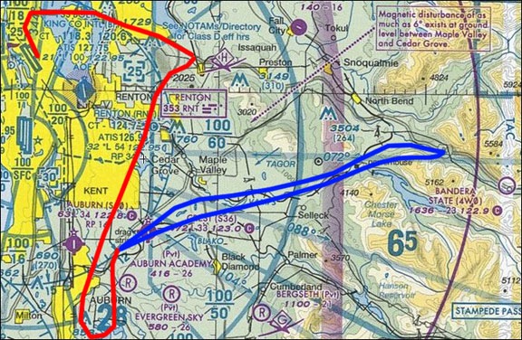
But I didn’t get very far. As I moved eastward over I-90, visibility started to deteriorate. I wasn’t much past Renton’s airspace when I saw a thick rain shower ahead of me over the Interstate. I’d been taught at the Grand Canyon that if you can see through it you can fly through it. I couldn’t see through this one. And I wasn’t anywhere near the pass I’d have to slip through to get over the Cascades. Obviously, this wasn’t the way to go.

I doubled back, calling in to Renton’s tower to get permission to transition along the east side of their airspace. I figured I’d head south — possibly as far at the Columbia River — and go around the mountains. That would turn a 45-minute flight into a 2-1/2 hour flight (at least). But as I traveled south, I could see that the visibility situation was worse than the weather radar indicated. I got past Auburn and knew I couldn’t complete the flight at that time.

I had two choices:

  • I could return to BFI and hang around in the mechanic’s office and wait until the weather got better. I had no transportation there, so I’d be stuck there. If I got stuck there all day, they’d eventually kick me out and I’d have to either fly out or get a cab to a motel and return the next day for departure.
  • Don's Heliport

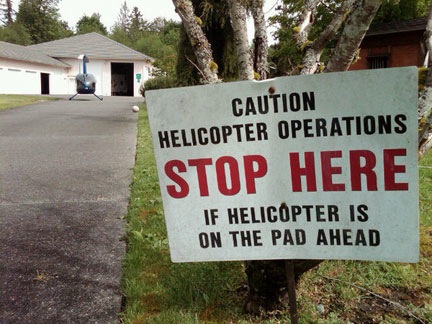
    Don’s Heliport, photographed with his helicopter on the “pad” on a nicer day.

    I could fly to my friend Don’s private helipad in Auburn. He’d already told me I could do that if I needed to. There I’d find a comfortable place to hang out with friends and both a television and wifi to check the weather. I’d also be able to draw on Don’s weather local experience to determine the best time to make another attempt. If an overnight stay was required, they had a nice guest room.

Which would you pick?

The trouble was, Don’s heliport — although logged into the FAA airport database — was not on my GPS. I’d only flown in once with him — as a passenger. I knew some of the landmarks. But I also knew that it was completely surrounded by tall trees and impossible to see until you were literally right on top of it. So I had to go hunting. In the rain. I figured I had about a 50% chance of success.

I did eventually find it. It took about 10 minutes. On the ground, Don heard me and quickly pulled his truck and trailer out of the landing pad. He’d just gotten it out of the way when I spotted it. I circled around to make the steep approach. I came in a bit too slow and steep, but I made it work. Not bad for the first landing.

We checked the weather together and decided I should wait a few hours. I accompanied them on a few errands. It was raining the whole time. We got back and checked the weather again. Radar showed a huge storm system moving northwest from the other side of the Cascades. My buddy, Jim, who had started a cherry drying contract in Mattawa, would probably be flying. We looked at the Washington State Department of Transportation Web site traffic Web cams in the passes. We checked Duats and got information for Stampede Pass, which was not far from the pass on I-90 that I’d be crossing. Conditions changed by the minute.

Second Attempt

Finally, at 6 PM, I decided to try again. I said my goodbyes, started up the helicopter, and climbed up through the trees. The scene from up there was surreal. Wispy patches of thin clouds rose here and there from the tops of the tall pines. To the west and south, the sun had broken through the low clouds, illuminating the ground with rays of light. To the north, I could clearly see the Seattle skyline. To the east, however, things weren’t as rosy. There were scattered rain showers and patches of fog.

My initial plan had been to follow Route 18 to I-90, but Route 18 led right into a thick rain shower. So I punched Bandera (4W0) into my GPS and took a route that was southwest of 18, heading east northeast. I hit I-90 just before it made a sharp turn into a canyon. The clouds were very low there and I’d have to fly about 200 feet over the freeway to enter the gap. While there was a chance that the ceilings could rise right beyond that point, it was impossible to tell from my position a mile or so away. And I was still 7 miles from Bandera, which was still several miles from the pass. The likelihood of getting through there without hitting wires was slim to none.

Afternoon Clouds

Another crappy photo, but it should give you an idea of those wispy clouds coming up through the trees.

I turned around and retraced my route to Don’s place. To the south, there was a lot of bright sunlight. I was pretty sure I could go that way and follow the Columbia River around the mountains. But the flight would take 2-1/2 hours and I’d have to stop for fuel. Sunset was at 8:45 PM. It was already 6:30 — too late to make the attempt.

Of course, I’d forgotten to mark Don’s place as a waypoint on my GPS, so I had to hunt for it again. I found it a bit quicker and made a much better approach and landing. I was there for the night.

I’d been gone 30 minutes.

First Two Attempts

My first two attempts on a Seattle sectional chart. Red is my first try, blue is my second.

Third Attempt

I woke to fog. We checked the weather on the Internet and on television. We also called another pilot who lived nearby and had a better view of the sky to get her input. By then, I was so sick of checking the weather that it ceased to have meaning for me. After all, few of our sources gave me the information I really needed: how high were the could bottoms above the ground? What was the visibility in the mountain passes? A direct flight to Quincy from Auburn was less than 100 nautical miles. Although I couldn’t make a direct flight, my goal was to make it as direct as possible.

You need to understand here that this isn’t the first time I’ve had to take the helicopter across the Cascades. It was going to be my seventh. Weather had been an issue on four of those previous flights, but never this bad. I just wasn’t willing to accept it.

So when the fog cleared and our contact a few miles away reported ceilings of about 500 feet, I decided to try again. Don topped off my fuel tanks with another 15 gallons of fuel. I said goodbye again, started up, and climbed back up through the trees.

Nice Weather

This is the nicest bit of weather I came across. This shot was taken about 15 miles south of Auburn at 9:18 AM.

Up top, I was surrounded by poor visibility. I could probably see 3 miles, but not much more. I was certain that I’d be wasting my time if I tried for the I-90 passes again. So I headed south toward Portland, OR. As I flew, the weather improved.

As I flew, I never lost hope of getting across the mountains another way. Although my general direction was south, I kept trying to find passages that would take me more to the east. I followed one particular valley for quite a while, climbing ever so slightly along the way. Then my way was blocked by clouds touching the tops of the tall pines all around me. Discouraged, I turned around to backtrack out of the valley.

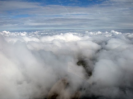
View from Above the Clouds

View from above the clouds. I was probably heading westbound when I took this shot after aborting my first canyon passage. 9:30 AM

A big hole in the clouds opened up, revealing blue sky. I pulled pitch, pulled the cyclic back, and climbed out at about 1200 feet per minute. Above the low clouds, the view was disheartening. The cloud tops varied in height and another layer of clouds seemed to meet them on the horizon to the east. The bright, snow-covered top of Mount Rainier seemed to taunt me, shining in the sun less than 30 miles away. On a previous westbound flight, I’d flown above the clouds just north of the peak, dropping down into a valley on the west side to complete my flight. It didn’t look as if I’d be as lucky to find a path back through the clouds on the east side that day so I wasn’t about to attempt it.

I caught sight of a lake to the west of my position through another big hole in the clouds. I dumped the collective and glided down at 1700 feet per minute, banking right and then left to dodge clouds on my way down. Safely under the clouds again, I continued south.

Eventually, I hooked up with Route 12, another of the roads that crosses the Cascades. I followed it eastbound in a pleasant valley dotted with homes, farms, and lumber mills. The clouds overhead were low but mostly broken, so there was plenty of sunshine — enough to turn off the heat and crack the air vent. I tracked my position on the sectional chart. White Pass was at 4500 feet. If I could get through that, I’d be able to follow the road to Yakima.

I passed the last town in the valley and the road began climbing into the mountains. I climbed with it. Then I decided to take a chance above the clouds again. I climbed up through a big hole, reaching 6,000 feet before coming out on top of the lowest layer. The clouds were taller here, some of them starting to show signs of convective activity. Although I was atop many of them, I had to fly around others. My GPS assured me that the road was beneath me, but I couldn’t see it. I also couldn’t see Mount Adams, which I knew was very nearby. The clouds were thick to the east. I knew that to an onlooker, I probably looked like a tiny speck of red among the giant puffy clouds and rocky peaks around me.

And that’s when I scared myself. I flew into a sort of box canyon of clouds. The only way out was back the way I’d come and down. I dumped collective and pulled the cyclic over. Within a moment, I was banking hard to the right at at least a 60° bank angle, descending at 1000 feet per minute. Adrenaline rushed into my system, making my entire body feel the dire emergency situation I was in. In less than 15 seconds, I was clear of all danger, but it would be at least 30 minutes before that adrenaline rush was completely gone.

I won’t do that again.

I flew back to that nice little town with the initial thought of landing there at its airport and waiting for the weather to improve. But I realized what an idiotic idea that was. The weather there would not improve soon enough and the town was too small to have a motel or even fuel at its airport. So I continued on my way, backtracking along Route 12, westbound through the valley.

At Randle, there was a road that cut south through the mountains. It looked like it might be a shortcut to the Columbia River Gorge east of Portland. I still had half tanks of fuel so I figured I’d give it a try. Soon I was flying through a spectacularly beautiful little valley, over a rushing river. Every once in a while, I’d catch sight of the paved road between the tall pine trees. The road climbed and I climbed with it.

Then the inevitable — a wall of clouds right behind a ridge. I circled, looking for the road, wondering which way it went. The neat thing about mountain roads is that they’re usually built on the easiest path to cross mountains. That’s what makes them so good as navigation tools when you need to fly a helicopter over some mountains.

When I spotted the road, I was surprised to see that it was covered with deep snow. It was obviously closed for the winter. I followed it slowly to the top of the ridge to take a peek over. If the land dropped down behind it and the clouds stayed high, I could continue. But if there was another ridge blocked by clouds behind this one, I’d have to go back. Again.

I was lucky. The ridge was the highest point on the road. The land fell away beyond it and the road fell with it. I popped over the top only 50 feet from the treetops and descended into a valley on the other side.

I punched Hood River into my GPS. I’d need fuel somewhere and Hood River seemed as good a place as any to get some. It was still 40 miles out. I flew directly toward it, put off by the amount of cloud cover all around me. I’d been hoping for clear skies in the Columbia River area but I wasn’t going to get them.

Mount St. Helens

A crappy, over-the-shoulder shot of Mount St. Helens. (You try taking decent photos while flying a helicopter.)

At one point, I saw Mount St. Helens over my right shoulder. It was covered with fresh snow.

Eventually, I changed my fueling destination to The Dalles. I hit the Columbia River abeam Hood River and followed the Columbia eastbound. I landed at The Dalles, called Don to assure him I was okay, and went inside to use the bathroom while the FBO guy fueled my helicopter.

I thought the worst of it was over. I even said that to the FBO guy before starting up again. But although the worst of it was over, there was still weather ahead. Unfortunately, I hadn’t taken the time to check the weather again while at The Dalles. So the low clouds and heavy rainstorms I had to fly through for the next hour or so were an unpleasant surprise.

Spot Messenger Track

As this SPOT Messenger track shows, my route from Seattle to Matawa was anything but direct.

It was cloudy but not raining when I landed in Mattawa to visit with my friend Jim. He and his wife drove me to a local restaurant where I could get something to eat and drink. We wound up spending at least 2-1/2 hours there, talking about flying and drying cherries and politics. As I was getting ready to leave, it started drizzling. Jim, who’d flown 2-1/2 hours the day before, smiled and thanked the rain gods. If the rain kept up, he’d fly again later in the day.

From Mattawa, it was only 20 minutes back to my base in Quincy. I overflew what looked like an AStar drying cherries on the north side of Mattawa. (Why he was drying while it was raining was beyond me.) In Quincy, I landed on a concrete pad at the ag strip across from the golf course where I’m camped out. The clouds were thickening in the area. I hitched a ride to the campground, got my truck, and put the padded blade covers on the helicopter.

It was good to get back to my comfy RV and Alex the Bird. I slept very well that night.