
Overused as a crutch by people without real photographic skill.
I’ve written this post primarily to share some thoughts about HDR (High Dynamic Range) photography, along with three links to articles by knowledgeable photographers that echo my sentiments.

Is this HDR?
If you’re not familiar with HDR imaging, it’s a type of photography that combines multiple exposures of the same image into one image, resulting in a greater range of luminosity in the final image. Shadow areas are brighter, bright areas are more detailed. The idea behind this is good and if done properly, the results are amazing.
The trouble is, it’s rarely done well.
Indeed, it seems that anyone with a digital camera and image processing software can spit out an HDR image. So they do.
And the result is usually crap.
Think I’m kidding? Check out I Hate Your HDR, which is a showcase of some of the junk people are showing off as great HDR photography. It’s crap.
HDR does have a purpose. When done properly, it enables the photographer to replicate an image as it might be seen by the human eye. Apparently few people know or understand this. Even fewer have the skills needed to do it right. As a result, most images created with HDR look anything but realistic.
Photographer Jim Goldstein discusses the technical aspects of HDR well in his article, “Why I Hate HDR: Photo Technology Porn.”
Photography Conquers Light

For pete’s sake, they’re even labeled!
Think for a moment about the most important aspect in photography: light.
HDR is an attempt to artificially conquer light. The photo you want to make has bright spots that get washed out and shadowy spots that have no detail. HDR combines multiple exposures — ones where the bright spots aren’t washed out and ones where the shadows have detail. Through software manipulation, the multiple images are made into one. The result should more uniform exposure of the image so you can see all the details.
In the old days, in a darkroom — am I dating myself here? — we used dodging and burning to achieve this effect. The tools to do this are still available in Photoshop. But apparently it’s easier to let software algorithms automatically cook up something on their own, adjustable only by sliding levers in a cryptic dialog. We’ve seen the results.
A skilled photographer doesn’t need a crutch like HDR to capture images with good dynamic range. Best of all, those images are not likely to look as fake — or “cooked up” — as so many HDR images do.
Real Photographers Don’t Need HDR
“HDR is Stupid and it Sucks” by photographer Lewis Collard is a great blog post because it illustrates images that look like they could be HDR, but they’re not. That tells me that HDR simply isn’t necessary.
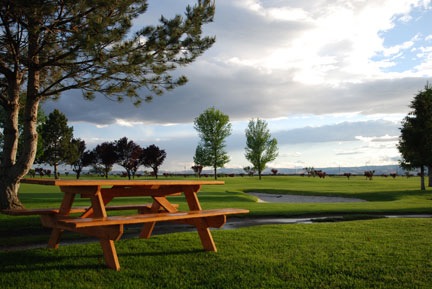
No, not HDR. This is the original.
And that brings me to the image at the top of this post. When I first put it online, a Twitter friend complemented me and asked me if it was HDR. The complement pleased me, but the HDR question did not. It’s not HDR. Instead, I captured the single original, untouched image you see here, brought it into Photoshop, and tweaked the Shadow/Highlight settings to bring out some of the detail in the shadows and bright sky. I then did something I don’t normally do: I punched up the saturation just a bit to bring out the colors. Having the image mistaken for HDR makes me wonder whether I went too far with my minor touchups. Why? Because most HDR looks like crap.
Interestingly, while some photographers “get it,” others so obviously don’t. The comments on this post are a perfect example, with half the group raving about all the images in the post while the other half is more critical and realistic, clearly seeing how some images have done HDR right while others completely miss the point. It’s amazing how people can be lured into thinking that high contrast and outrageous colors equals good photography.
That’s not the way it is and skilled photographers — or at least the people trying to capture reality with their cameras — know it.
A Caveat
Some people use photography as a basis for artwork. They purposely distort photographic images in an attempt to make “art.” (News Flash: Photography is art.) In my opinion, that’s the only excuse most of these people have for abusing HDR the way they do.
Don’t show me an HDR image with unrealistic results. I won’t be impressed. Hell, anyone can cook up a photo with digital editing tools. Even me.
Show me an HDR image that doesn’t look like one. Then I’ll be impressed.


 Today I was contacted by a similar organization. This one, which I refuse to publicize with a company name or link, gets businesses to offer special deals on goods and services on the organization’s Web site. They sell the deal and then take a “commission for the use of the platform.”