Some photos from a real off-road experience.
This past Sunday, Mike and I took the Jeep up the Hassayampa River. Way up the river.
As folks around Wickenburg know, the Hassayampa is mostly dry. The water does flow year-round, but in most places, it’s below the sandy surface. In rocky areas, it flows above the surface as a small stream.
Unless it’s rainy (or has been rainy). Then it’s a real river and should not be driven in.
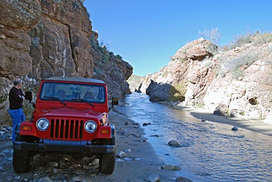
 On Sunday, it was running only slightly higher than usual. We entered the riverbed near the end of Rincon Road, where it climbs up to meet Scenic Loop. There was an old manganese mine there and the dirt road is black. Going straight (instead of making the left turn) takes you on a narrow track to the river. From there, it’s just a matter of following the tire tracks left by other vehicles.
 We made a few brief stops. Box Canyon was one of them. But there were motorcycles there with loud engines and we didn’t stay long. Instead, we continued upstream, into the narrow slot canyon. The water flowed from wall to wall within the canyon and I had the windshield wipers going as I slipped around in the soft sand. We stopped for a moment to take a photo of the way we’d come.
We passed through the first gate just short of Boyd Ranch, above the floodplain on our left. We passed through the second gate just before Fools Canyon. Right about there, a group of five sand rails (dune buggies) and a yellow Jeep caught up with us. (We weren’t rushing.) We pulled over to let them pass.
In many places, four wheel drive was required. So was high clearance. So unless you have a Jeep or similar vehicle or an ATV, this isn’t the kind of drive you’d want to make. You’re driving in the river, with water splashing up all around you, in many places. There’s quicksand there, so you want to keep moving anywhere the sand is soft. Gnarly tires are definitely a plus.
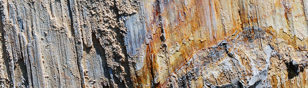
 We passed many interesting spots where Sonoran desert meets year-round stream. The variations in the rock were amazing. I took quite a few photos. Some of them are in my Photo Gallery.
We were about two miles past Fools Canyon when the group that had passed us came back. One of the drivers stopped to report. “You can’t go much farther,” he said, “but it’s worth it. There are some old foundations up there.”
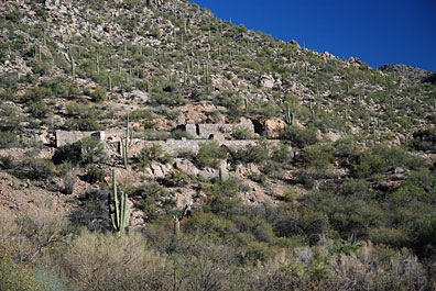
We continued on. The river was flowing through a canyon, but the way was still passable. We soon saw the remains of a mine site on the right side of the hill. We turned the Jeep into a promising canyon where other vehicles had driven but soon reached a dead end where rocks blocked our way. We parked, got out, and hiked up the hill.
It was an interesting mine site, with some seriously heavy-duty foundations. I don’t know much about mining, but I do know that they used gravity to process the ore. That’s what most of the “foundations” were for.
 Following a narrow path for a better view down into the river, I came across a tunnel carved into the solid granite at the side of the hill. We passed through and continued onto the other side.
A bit farther down the pathway, we found the remains of a wooden mining structure, as well as some partially buried railroad steel. Evidently, the path and tunnel had been used by ore carts or some similar conveyance. Most of the steel had been removed; the one piece we saw had been buried under a rockslide.
As we admired the view, we heard the sound of a vehicle. Down in the riverbed, a truck was driving downstream. It stopped only long enough for the driver to point out a mine shaft to his passenger, then continued on down the river. I don’t think they saw us or our Jeep.
We left a while later and spent a short time exploring the severely vandalized remains of a home across the river. Then we headed back, stopping long enough to take a few photos along the way.
We were gone about five hours and had covered about 40 miles roundtrip. We took Scenic Loop from just past Fools Canyon on the way back, minimizing our time in the riverbed.
I checked all the maps I have for the area and the mine does not appear on any of them, so I don’t know it’s name. I do know it well, however; I fly over it every time I take a tour up the Hassayampa River in my helicopter. It’s nice to know what it looks like close up.
 Mike took this shot as we began our flight uplake. It features Padres Butte, which is known by local tour pilots as “submarine” because it looks like a submarine conning tower. There was very little wind on the lake the reflections were outrageous. The lake is as blue as ever, but if we’d taken this shot later in the afternoon, the buttes and surrounding cliffs would have looked much redder. This shot was taken around 1:30 PM.
 We made a few brief stops. Box Canyon was one of them. But there were motorcycles there with loud engines and we didn’t stay long. Instead, we continued upstream, into the narrow slot canyon. The water flowed from wall to wall within the canyon and I had the windshield wipers going as I slipped around in the soft sand. We stopped for a moment to take a photo of the way we’d come.
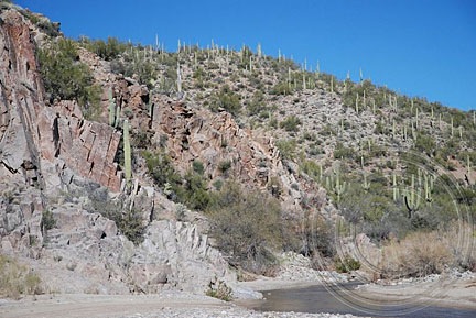
 We continued on. The river was flowing through a canyon, but the way was still passable. We soon saw the remains of a mine site on the right side of the hill. We turned the Jeep into a promising canyon where other vehicles had driven but soon reached a dead end where rocks blocked our way. We parked, got out, and hiked up the hill.
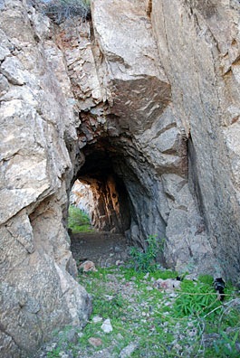 Following a narrow path for a better view down into the river, I came across a tunnel carved into the solid granite at the side of the hill. We passed through and continued onto the other side.
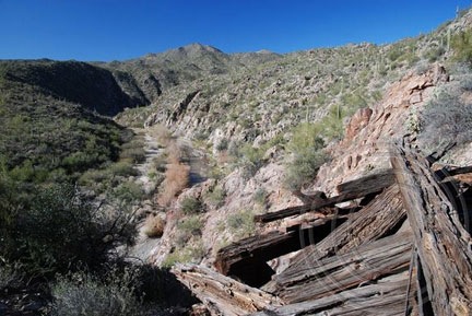
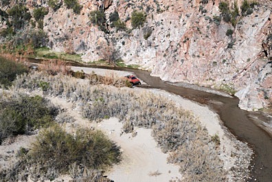 As we admired the view, we heard the sound of a vehicle. Down in the riverbed, a truck was driving downstream. It stopped only long enough for the driver to point out a mine shaft to his passenger, then continued on down the river. I don’t think they saw us or our Jeep.

