From the train.
 In June 2007, we made our first-ever trip to Alaska. The first part of the trip was a short stay with friends in Anchorage, followed by a train ride to Denali National Park. The much-touted train ride was long with plenty of scenic bits. The highlight was this view of Mt. McKinley, which I snapped from our train car seat.
Mt. McKinley, which is also known as Denali, is the tallest mountain in North America. It stands over 20,000 feet (that’s nearly 6,200 meters for those of you in the rest of the world) and is perpetually snow-capped. It also is usually surrounded by clouds, as you see here. My shot is actually considered a relatively good photo, since the mountain is hidden more often than not. (The link at the beginning of this paragraph includes an excellent photo taken from within Denali National Park.)
I enjoyed the train ride to Denali but the return ride was overkill. I also wish that we’d stayed inside the park rather than in the horrible little tourist town the cruise ship companies have built just outside the park entrance. (You can read more about our trip to Denali here.) The park is full of wildlife but access is severely restricted. Although you can see plenty of animal life from the tour buses you have to take to to get more than 16 or so miles in (I can’t remember exactly), hiking is somewhat limited along the tour bus routes. The overall feeling in the park is that 99% of the visitors see everything through a bus window. That’s not how we normally experience National Parks.
Anyway, my recent trip to Alaska has made we want to visit again. Next time, I’ll spend more time in the park, away from the crowds and closer to the natural beauty that brings them there.
And maybe — just maybe — I’ll get a cloud-free glimpse of Denali.
 Monument Valley is on the Navajo Reservation, which is the largest of all Native American Reservations in the country. Access to the rock formations we know as monuments is controlled through the entrance of the Navajo Tribal Park. There are reasonable fees for entering and driving your own vehicle into the park. But for an additional fee, you can go with a Navajo Guide who will take you places you’re not allowed to go on your own. If you have the time, I recommend this, as it’s likely to be your only opportunity to step inside a traditional Navajo hogan.
 I normally fly to the park from Page along the southeastern side of Lake Powell. There’s a landing strip at
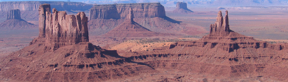
  Of course, to learn whether the tour would be good, I had to take one. I’ve actually taken the tour three times. I took this photo on the most recent trip. It shows two of the most famous monuments: the Mittens. They got the name because they look like those woolly things you might have worn in the winter as a kid. They’re formally called East Mitten Butte and West Mitten Butte. They stand hundreds of feet off the desert floor, towers of red sandstone that are still eroding in the high winds and summer storms of northern Arizona.
 The bird took off and I caught him in flight.
 I took this shot on the first glacier. It’s a huge boulder — probably 8 feet long by 6 feet wide by 3 feet tall — and it’s being held horizontally off the surface of the glacier by a column of ice. The ice, of course, is melting — not from global warming but by summer warmth — and I suspect this boulder is now lying elsewhere on the surface of the glacier, a bit downstream as it moves with the flow of the ice. Perhaps it’s sitting in a similarly awkward position and another tourist has snapped a shot of it — maybe with his wife or kid sitting or standing on it! That’s the weird thing about glaciers: they’re always changing, always moving. The rocks and boulders on their surface are just along for the ride.
 The Deception Pass Bridge crosses over this strait, about 180 feet above the water (depending on the tide). There are actually two spans to the bridge with a small uninhabited island between them. There’s limited parking on both ends of the bridge with plenty of places to stop and take in the view.
 The bridge includes a 3-foot wide sidewalk on each side, which is definitely not recommended for those who are afraid of heights. We walked across on one side and back on the other. To prevent people from crossing the relatively busy roadway, a flight of stairs leads to a pathway under the bridge on either bank. That’s where I took this photo. I liked the symmetry of the construction and the fact that I could frame the photo in such a way that the pattern seemed to go on forever. This is a theme I try to capture in my photos when I can: infinity.