2018 Entiat River Mushroom Hunt, Day 1: Getting Started

I go off the grid for four days to hunt for morel mushrooms.

One of the best things about being single is all the time I have to do my own thing. Since my divorce started back in 2012 (and eventually ended years later), I’ve picked up a number of new hobbies, some of which are seasonal. Mushroom hunting is one of these hobbies.

Mushrooming Since 2015

I started learning about foraging for mushrooms at a weekend-long class at the North Cascades Environmental Learning Center in October 2015. Not long after that, in May 2016, I went on my first morel mushroom hunt with my friend Sue. I actually went out several times, both alone and with Sue, to a variety of places. We did okay — good enough to have morels with a handful of meals.

If you’ve never had fresh morels, you have no idea what you’re missing. They are amazingly delicious. My favorite way to eat them? Dust with flour, salt, and pepper, and sauté gently in butter. Holy cow. I also made a morel mushroom pizza which wasn’t bad; I’d certainly do it again if I brought home enough mushrooms to want variety in how I eat them.

The same year, I joined the Puget Sound Mycological Society (PSMS), mostly so I could go on their Ben Woo Foray just outside Mount Rainier National Park. 2017 was a very wet year and I saw, in 10 minutes, more mushrooms on the grounds of where the event was being held than I had all summer long on the relatively dry east side of the Cascades where I live. I learned about other edibles — which is honestly all I care to collect — and brought home enough to eat and freeze and enjoy. Heck, I was still eating chanterelles that winter when I took my camper down to Arizona.

The PSMS has other outings and a handful of them are on my side of the mountains in the spring. Last year, I joined the group for a weekend camping trip at Silver Falls Campground about 30 miles up the Entiat River. I came in my truck camper on Friday afternoon and was one of the first to arrive in the group campground. Soon others were pulling in after a very long drive from the Seattle area. It was not a successful weekend, at least as far as mushroom hunting is concerned. I think we were about a week too early. I came back the following week and tried again on my own. The woods were full of mushroom hunters and we were all looking for the same thing: morels.

Up the Entiat

The Entiat River valley is a perfect spot for them. There were huge forest fires in 2015 that devastated much of the valley beyond Silver Falls and did some serious damage to the Silver Falls area. The trail to the falls and even the campground were closed for more than a year. Since morels prefer conifer forests after a fire, it made sense to look there. But there was too much competition in 2017 and I came away disappointed on both trips with barely enough mushrooms for a side dish.

This year, I decided to try again — but with a bit of a head start. I figured I’d head up the Entiat two days early but continue past Silver Falls, all the way up to Cottonwood campground eight miles farther at the end of the road. The road had been closed about a mile past Silver Falls the previous year but a call to the ranger station assured me that it was open. And although Cottonwood campground was technically closed due to fire damage, it wasn’t gated. I was told I could use it as long as I hauled out my own trash.

I had a slight idea of the fire damage the ranger told me about. I’d flown up the canyon a few times the previous year. One of my favorite helicopter joy rides, often with friends, is to follow the Columbia River to the mouth of the Entiat River, then head upstream and follow that to a fork in the canyon. If I make the right turn, I can pop over a ridge not far from Holden Village and Lake Chelan. From there, I follow the lake up to Stehekin. In the spring, there are too many waterfalls along the way to count.

Anyway, I’d seen what looked like a campground from the air in a piece of forest with nothing but blackened towers of burned trees. That was either Cottonwood or one of the ones along the way. Lots of fire damage. Would that mean lots of mushrooms?

There was only way to find out.

A Late Start

There were a bunch of things I needed to do at home before I could head out. First and foremost was an article I was supposed to write for Vertical magazine that I had put off too many times. My deadline had been Friday and here it was on Wednesday and I still hadn’t written a word.

The trouble is, I do my best writing in the morning. Actually, I do my best everything in the morning. But the morning is also when it’s cool out so that’s the best time to work on my garden and do other outdoor things. I’d been promising myself that I’d work on the article in the afternoon, when it was too hot outside to work. But I never did. Now I realized that if I didn’t write the article, there was no way I’d be able to get it to my editor for another week. And since I’d already missed one drop-dead deadline on this piece, missing another would not be a good idea.

So I climbed up into my loft-based office, fired up my computer, and got to work. Three hours later, I had a 1600-word interview all ready for review by my subject. I emailed it to him.

Then I had to move the “outhouse” I use with my glamping tent. (I really need to blog about that setup and my most excellent portable toilet.) I’d moved it down close to the tent for guests about two weeks ago. Now it was time to dump it and reposition it in a more permanent place for the season. I didn’t like where I had it. And the damn thing had already blown over once in heavy wind — thankfully, it had been empty — and I needed my neighbor’s backhoe to get it back on its wheels. I didn’t want that to happen again when it was full. (Ick.)

Moving it took about an hour, mostly because I had trouble getting it hooked up to my ATV’s front hitch. Then a very slow drive up the path from the tent, around the driveway edge, and in place near the big aspen tree by my garden. I needed to borrow the sewer hose from my camper to make a hose long enough to reach the sewer connection in my driveway. Finally, I secured it on jacks so it wouldn’t topple over again.

By that time, it was time for lunch. I had leftover lamb shank.

Next, I had to prep the camper. That meant pulling out a lot of the things I’d left in there after my winter travels that I wouldn’t need for my upcoming trip. When I went to make the bed, it was pretty obvious that the cats had been in there — the bed was covered with cat hair. So I had to get out the shop vac and suck all that hair out. I vacuumed the rest of the rig, too. Then I made the bed, organized the kitchen and bathroom and dining area, and started to pack up the things I would need for the trip, like food and my jewelry-making stuff and my drone.

Then I needed to raise the camper on its legs, back the truck under it, lower the camper onto the truck, and secure the camper to the truck using the tie-down straps. That took about 20 minutes; I’m getting good at it.

The clock was ticking loudly. I knew that if I left home after 6 PM, there was a good chance I’d get to Cottonwood campground after dark, which was definitely not what I wanted. By the time I was ready to take a shower and pack up my clothes, it was 3:30. And that’s when I realized that I hadn’t reviewed the comments my interview subject had emailed back to me.

So I climbed back up to the loft, opened the file he’d emailed back to me, opened my Word document file, and went through the few edits he’d sent. I proofread the article and emailed it to my editor with apologies for being late.

It was 4:30 PM when I finally got into the shower. I needed a serious scrubbing — I’d been sweating all day — and had to wash my hair. So a long shower.

Then getting together my clothes and more food items. And checking off items on my list, some of which needed fetching from various places all over my home and garage and tent. And chicken coop — I needed to bring eggs.

It was 5:30 PM when I finally locked up the house and rolled out of my driveway.

I needed to make one stop: the local Fred Meyer supermarket. I wanted to get a few grocery items: sushi to munch on in the truck, a roasted chicken, and some salad. And I needed fuel for the truck. I was pleased to get a 50¢ gallon discount when filling the truck’s huge tank, even though I still had a quarter tank of fuel.

If stopping for propane would have been easy, I would’ve done it. But the RV dealer on the way out of town was closed and it would have been a time-consuming ordeal at a convenience store. I was pretty sure I had enough propane on board for the trip so I skipped it.

I rolled out of Wenatchee at 6:33 PM.

The Drive Up

It was not a long drive — not in miles, anyway. The campground was 38 miles up Entiat River Road. The turn for that was maybe 10 miles from Wenatchee’s north end bridge. So figure about 48 miles from where I crossed the river from the East Wenatchee side.

It was surprisingly windy along the river. Although it had been a nice day with partly cloudy skies, storms were in the forecast and, from my home’s position on the hillside, I’d seen sheets of rain falling in various directions. But once I was on the road, I no longer felt in a hurry. I set my cruise control for 55 in a 60 mph zone to make it easy to drive my high profile load. The only other vehicle on the road going my way was a police car, which passed me.

There was no traffic at all in either direction on Entiat River Road. Sure, there are homes up there, but I guess everyone was home. The road runs alongside the river, which was running high and fast from snow melt up in the mountains. The next two rivers up the Columbia — the Stehekin, which empties into Lake Chelan, and the Okannogan — were at flood stage. The Entiat was close but none of the bridges across it were closed and there was no flooding on the road.

The farther upriver I got, the narrower and twistier the road became. It was actually a great motorcycling road — I’d taken my bike up to Silver Falls several times for a hike. But behind the wheel of a high CG vehicle, it wasn’t much fun.

Most of the valley was in shadows when I made my turn. I’d periodically get a flash of late afternoon sun in my face, but after a while even that stopped. My average speed dropped from about 50 when I made the turn down to 30 when I entered the national forest.

I was very surprised to see a gate closing off Silver Falls campground. The sign at the beginning of the road had listed all the campgrounds from Silver Falls on as closed but I was going by what the ranger told me. I hoped there was no gate at Cottonwood. But even if there was, I’d deal with it. One of the great things about traveling with a truck camper (or a camper van or a small motorhome) is that it’s easy to park and when you do, you’re camping. So if there was a closed gate at my destination, I’d simply find a place to park off the road out there and settle in for the night.

About a mile past Silver Falls I reached the gate at the road that had been closed the previous year. It was open, as I expected, and I kept going. By this point, I was into the fire damaged area. The sun, although still shining on the tops of the mountains around me, was not shining anywhere in the valley. Still, I could easy see the fallen trees and burned stumps. In some places, where were still tall live trees but in others, there weren’t. At one point, a sign warned of a narrow road for a half mile and the road went down to one lane with tall embankments on both sides. Fast running creeks came out of the hills on my right and formed channels of water on the other side of the embankments; clearly they had been built there to stop flooding and erosion on the road.

And that got me thinking about the kind of damage forest fires do. It isn’t just burned up trees and undergrowth. It’s the subsequent erosion caused by rain and snowmelt on terrain that is no longer able to contain or slow down the running water. It’s the debris that clogs streams and causes them to reroute in directions that road planners never expected. It’s the undercutting of roads and bridges. It’s the layers of ash that choke off oxygen to the soil, making it difficult for plant life to return.

One by one, I passed the other campgrounds along the way. None of them were blocked off, although one had a paper sign over its regular sign that said “Day Use Only.” All of the signs on the right side of the road that had once identified the campground by name were gone. Only the structures that had once held the signs remained.

The pavement ended and I continued on. By this time, I had caught up with an SUV. Although I was only going about 20 to 30 miles per hour, he pulled over to let me pass.

Small creeks crossed the road and I drove right through them. Three of them. None of them were deep, but the road was definitely being eroded. The road climbed some hills and descended on the other side. The landscape was full of the burned remains of once tall conifers.

And then I was at Cottonwood campground. Like the other campgrounds, its sign was gone, but a road sign pointed me to it. I turned left, crossed a bridge over the raging Entiat River, and followed the road around to what was left of the campground.

At Cottonwood Campground

I say “what was left” of the campground because it was a mess. If there had been cottonwoods there, they were all gone. Most of the trees were gone. The campground was basically an open field full of burned tree stumps.

At Cottonwood Campground
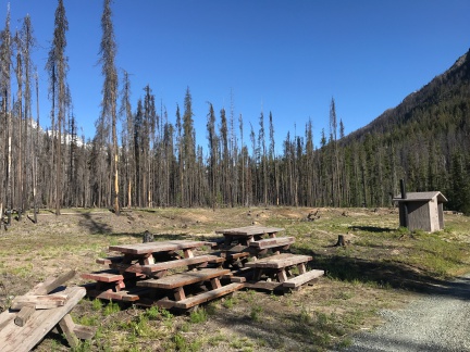
I shot this photo the next day. I have to wonder where the cottonwoods were.

Somehow, the bathroom buildings had been spared. They stood almost evenly spaced alongside the road among neatly stacked piles of lumber and heavy wooden picnic tables.

I drove down to the end of the campground and followed the loop back to the road I’d been on. It was hard to identify where the sites had been. Fire pits were my only indicator in some places. Fallen trees blocked off what might have been driveways or parking areas. It would take a lot of man hours to get this place back to the way it had been — even without the trees. It had already been more than two full years and they had a long way to go.

What a shame.

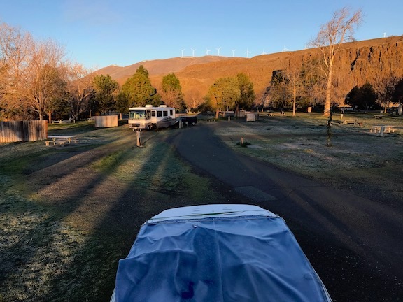
I found a driveway that led down to two or three spots along the river that were still intact and turned into it. At the end, I had quite a challenge turning around my rig in an area that might have measured 30 feet square with obstacles that included trees, a piece of rebar in the ground that would have made short work of my truck tire, and huge stones. At one point, I thought I was stuck, but since stuck wasn’t an option, I kept trying. After about 20 forward/reverse maneuvers with me getting out of the truck to look for that piece of rebar every time, I finally got it turned around. I backed into one of the spots and stopped when the truck seemed level.

My Camper at Cottonwood
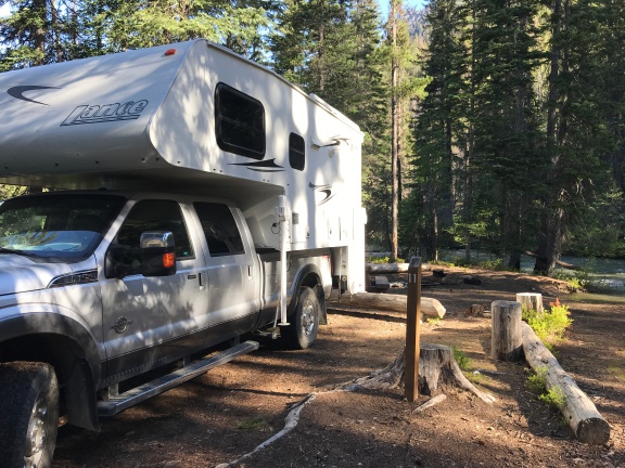
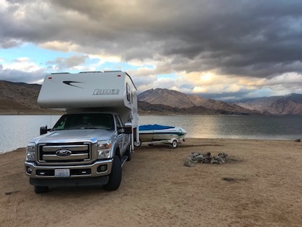
I took this photo of my camper in its overnight spot the next morning before pulling out. This was one of the few undamaged spots in the campground.

It would have been a pleasant spot if it weren’t for all the fire damage around us. The river was only 20 feet away. I had a picnic table and a fire pit, neither of which got any use.

And yes, I was the only person there. I had the whole campground to myself. The only sound was the water rushing by.

By that time, the sun had gone down and it was beginning to get dark. The SUV I’d passed a while before pulled into the campground, drove down to the end, and then drove out. I never saw it again.

Penny and I went for a quick walk around, mostly to stretch our legs and give Penny a chance to do her business. Then, since it was starting to get chilly, we went back into the camper and closed it up for the night. I had some chicken and a salad for dinner; Penny got the chicken fat and skins with some chicken juice over her kibbles.

We were in bed and asleep by 9:30 PM.

More to come…

The Long Road Home

I make my way home from my winter travels, slowly but surely.

I’m writing this in my RV at a campsite in Maryhill State Park in Washington State. As I so often do when traveling through the area, I arrived late enough in the afternoon to stop for the night. Yes, home is only a 3-hour drive from here, but I don’t like driving at night. I have come to use Maryhill as a sort of post-trip celebration spot, a place I wind down from a long trip and start getting myself mentally prepared for my return to home.

As usual, the campground is nearly empty and I got a nice pull-through spot along the river. There’s electricity and a sewer dump at my site, but the water is still turned off for the winter. That’s okay; I filled up my fresh water tank in Las Vegas before I left and have plenty of water left.

Away from the Camper

Las Vegas is where I went after my helicopter mishap on February 24. My truck, camper, and boat were waiting there for me in a “storage” site at the Sam’s Town KOA. Although I generally avoid KOA camping, I really do like the one in Vegas for what it is: city camping. With my small rig, I can take one of the double-width sites along the edge of the campground property and not be right on top of my neighbor. I’d parked the boat beside the truck and camper before coming home in mid February to fetch the helicopter and take it down to California for a frost contract. I was able to plug in to power, which saved a ton of propane for the fridge, and the KOA folks charged only $15/day while I was gone. It was good to leave my stuff in a place I knew it would be safe.

The original idea was to go right back to Vegas after tucking the helicopter into a hangar at Yolo County Airport, but the weather in the Sacramento area turned cold and I wound up in a Woodland motel for a week in case I had to fly for frost control.

I spent my days goofing off, going as far as Calistoga for a mud bath and facial one day. (I am a sucker a good facial.) I managed to visit two wineries for tastings before heading back.

When I finally got to fly, the flight was very short with a bad end.

After being discharged from the hospital’s emergency room, my friend Sean took me to see the wreckage and we pulled out the last few personal possessions I had in there. (Sean had already collected quite a few things.) We stowed them in the hangar. Then I drove my rental car to Sacramento Airport, dropped it off, and waited in the terminal for a Southwest flight back to Vegas. With no helicopter or frost contract, there was no reason to stay in Woodland.

In Las Vegas

I was back in my RV by 6 PM. As you might imagine, I had a little trouble getting to sleep. Every time I closed my eyes, I’d see those damn trees in front of me. But putting the TV on seemed to help. And I eventually got a decent night sleep.

I took a full inventory of my bruises the next morning in the shower. That day — Sunday — is when the soreness really kicked in. I later learned that the helicopter impacted the ground at least twice before coming to rest against a small berm in the field where I crashed. I must have been like a rag doll in there with my muscles all tensed up from the adrenaline rush. (I don’t remember any of it, but without a head injury, I don’t think I passed out. It’s just blank.) Once my muscles relaxed a little, every single one of them got sore. The ibuprofen I was taking took the edge off.

I started the active part of my day by repositioning my truck, camper, and boat to a site on the south side of the RV park. It was a nice site with grass behind it — which is good since the camper’s door is in back. I hooked everything up — electricity, water, and sewer — since I’d be staying for the week.

I went to the convention center to meet up with my friend Zac from HAI (Helicopter Association International). The show wasn’t open yet, but he was in charge of guiding the helicopters in to land in the Convention Center parking lot. From there, they were wheeled into the building to be put on display. He got me an exhibitor pass so I could come in for a behind the scenes look at the show getting set up. Later, I joined him outside to watch (and broadcast on Periscope) a few of the helicopters that came in. It was fascinating and a lot of fun, but the walking really took a toll on me. By 5 PM, I was spent.

Show Girl
Eve didn’t like the location of the booth so she hired a model to attract attention to it during the show.

On Monday, I helped my friend’s Jim and Eve, who own Rotorcraft Enterprises, set up their booth at the show. Jim invented Start Pac, a battery device for helping to start turbine engines. He has since branched off into a bunch of other related products, including an APU for jets, a Start Pac for locomotive engines, and small battery devices to provide power when testing avionics on an aircraft. Jim’s a great guy — a former airline pilot who started flying helicopters in retirement. Like me, he lived in Wickenburg and left. I’m sure I’ve written about him elsewhere in this blog.

By the time we’d finished setting up, I was spent (again), but I went with them to lunch at a German restaurant near their office. Eating a good meal really picked me up. But I still went right back to the RV to relax. I slept a lot better that night.

Tuesday, Wednesday, and Thursday were spent at Heli Expo. I chatted with Pat Cox and Tim Tucker at Robinson to tell them about the crash and show pictures. They were very interested and even dragged Kurt Robinson over to see them. They were certain that the helicopter’s bladder tanks, which I’d whined about installing, had saved my life. I talked to the folks at Hillsboro Aviation, which had sold me my R44 back in 2004, about a new helicopter; I’m still waiting for a price quote but seriously doubt I’ll replace it with a new one. (They’re a lot more expensive now!) I walked the entire show floor and found a neat video solution for tours and YouTube videos; I might take the plunge and get a setup this summer. I met up with numerous friends, including one of the few people who had flown my helicopter without me on board and my first flight instructor, who now works for the FAA. I also walked the show floor early one morning, before it was open to the public, to get some really great photos of some of the helicopters there without people hanging all over them. I posted them all to Twitter.

The MD Booth
There’s nothing quite like walking a trade show floor before the public is let in. This is a panorama of the MD Helicopter’s booth on Thursday morning.

I treated myself to dinner at the MGM grand on Wednesday evening before heading back to my camper. And I took a break from the show at midday on Thursday to treat myself to a cocktail and lunch at the Wynn resort. So much of my traveling this winter has been low budget, so it was nice to get a few doses of luxury.

A Parisol Down
I sat along the pond at the Wynn’s Parasol Down cocktail lounge. It was a nice, peaceful escape from the Heli Expo show.

On Thursday afternoon, the show closed promptly at 4 PM. By 4:15, they were wheeling helicopters out the door. I joined my friend Zac again with Jim and another Start Pac employee tagging along to watch the departures. I broadcast on Persicope and they featured the video so I soon had hundreds of viewers. I think a total of 10 helicopters left. The rest would leave the following day. Zac invited me back but I’d had enough.

Leaving Las Vegas

The next morning I had breakfast at nearby Sam’s Town Casino, then packed up leisurely and was on the road by 10 AM. It was wicked windy out as I headed down I-15 toward Los Angeles.

Camping at Lake Isabella
My campsite on the shore of Lake Isabella.

Although I usually drive through Death Valley on my way to Sacramento with my rig, I decided to take a more southern route this time, hoping to avoid snow in the mountain passes near Lake Tahoe. I was aiming for Lake Isabella, in the foothills of the Sierra Nevada. I arrived about a hour before sunset and got a nice campsite right on the lake.

Lake Isabella at Dawn
I shot this from my camper’s back door at dawn at Lake Isabella. It was an amazingly beautiful morning.

The following morning, I was back on the road. I think it was then that I realized how much I just wanted to be done traveling. So I made my way out of the mountains and joined route 99 north. I took that all the way to Sacramento, then hopped on I-80 to Davis.

In California Again

I stopped at the same hospital I’d been in the week before and checked myself into the ER. A number of friends had suggested that blood clots could be an issue. The bruises on my lower legs were horrendous with a few painful spots. Although I no longer needed ibuprofen for pain, I was starting to wonder whether I had a bigger problem than just bruises.

I stayed for about two hours. They did blood work and used ultrasound to scan my legs for clots. I got a clean bill of health but the doctor suggested that I get it checked again in a week.

I spent the night camped out at the hangar at Yolo County Airport. I parked right next to it. Around 2 AM, Sean arrived and sat in his car, waiting for a call to fly. I didn’t realize he was there until I woke at 4 AM. It was foggy out and the ASOS (Automated Surface Observation System) was reporting freezing fog. Even if he got a call, he couldn’t fly.

The fog was still thick when the sun rose. I got dressed for the day and went into the hangar to organize my personal possessions from the helicopter. I packed them in my truck for the ride home and said goodbye to Sean. I would not be back next year for a frost contract, but there’s a chance he’ll join me in Washington for cherry season this year.

The fog was localized; there was none north of Woodland.

I tried to retrieve my cockpit cover from the salvage guy, but it was Sunday and his place was closed.

I drove up to Williams to have lunch with another pilot fired of mine who was on a frost contract up there. I tolerated his mansplaining about how he finds his orchards in the dark. I deserved the lecture. But, at the same time, it didn’t really matter. I changed the subject.

I thought I might need to meet with the insurance adjuster and Sacramento FAA guy, but they didn’t need to meet with me. That meant I had no reason to stay in the area. So I left. I hopped on I-5, set the cruise control for 62, and headed north.

In Oregon

I tried hard to get to the Seven Feathers Casino in Oregon. Casinos make excellent overnight spots for RVers. They have big parking lots and good security. And being able to go in for dinner or breakfast the next morning is a real plus. But as the sun was getting close to setting, Seven Feathers was still about a hundred miles away and, like I said, I don’t like driving at night. (Besides, I suspect the boat trailer’s running lights aren’t working, although I know the turn signals and brake lights are.) So I wound up in a Walmart parking lot in Medford with about a dozen other RVers.

I walked over to the Outback Steakhouse and treated myself to a blooming onion, which I used to really like. They’re a lot greasier than I remember; I only ate about 1/3 of it.

The next morning, I was back on the road as soon as the sun was up and the overnight frost started to melt. Someone on Twitter had mentioned that the I-5 corridor was IFR (Instrument Flight Rules) and he wasn’t kidding. I drove for two hours through big patches of fog.

My first destination was McMinville Airport where a 2005 R44 was for sale. I had an appointment to meet with the owner at 11 AM. It was a 4-hour drive from Medford and I was a little late because I had to stop for fuel. I saw the helicopter, which is only a few months newer than mine was and it looked fine — but not like mine inside. I still haven’t decided if I’ll put an offer in on it.

From there, I drove another hour north to an Apple Store in Tigard. I had a heck of a time finding parking — the store was in one of those modern outdoor malls designed to look like a downtown area. Nice place and I would have loved to spend the day shopping there, but I had a mission. I needed to buy a new iMac. The one I have at home, which is now 7-1/2 years old, refuses to start. It had been on the fritz for about a year, but it’s now dead. I think it’s a logic board or possible a video card problem. It doesn’t matter. I’m replacing it.

I wound up with a 27-inch iMac. I had to wait while they expanded the RAM from 8 GB to 16 GB. I had lunch at PF Changs while I waited. I ate too much. There was a bit of a challenge getting the computer out to my truck, but the Apple Store folks were helpful. Then I was on my way again.

I hit some early rush hour traffic in Portland — by this time, it was about 3:45 — before getting on I-84 eastbound. This is a really pretty drive along the Columbia River in Oregon, past numerous waterfalls in the Gorge area. I tried two state park campgrounds along the way but both were “closed for winter.” I knew Maryhill would be open. I stopped for fuel one last time in Biggs, OR, then crossed the river and pulled into the site I am in now.

I fed Penny but skipped dinner; I was still full from lunch.

Today’s Drive

The sun is now up, illuminating the basalt cliffs west of the park. The wind turbines up there are glowing bright white but are motionless in the still air. The frost on the ground is just starting to melt. My camper is warm; the small electric heater I brought along has been running all night. My next door neighbors pulled out a few minutes ago; we’ll leave in less than an hour.

Campground View
The view out my back door this morning. Note the frost on my boat cover and grass.

It’s an easy drive up route 97 to I-90 near Ellensburg. From there, I’ll head east to Vantage, cross the river, and come up back roads from George through Quincy to Wenatchee. I might stop at Fred Meyer for groceries to save myself a trip later on.

My house sitter left last night so I’ll have my home to myself. The cats will come out to greet us. I’ll collect this morning’s eggs.

And then I’ll go inside and run the water for a nice, hot bath.

There’s no place like home.

Postcards: Heli Expo Fly In

I’m at Heli Expo in Las Vegas this week. I arrived on Saturday evening after a week on a frost control contract in the Sacramento area. My RV and truck (and boat) were waiting for me, stored at the Sam’s Town KOA (don’t knock it until you’ve tried it) and I moved right back in.

A friend of mine who works for HAI was responsible for guiding in the helicopters that would be on display at the show. They fly in over the course of three days on a tightly controlled schedule and flight path. They land in the back parking lot of the convention center, shut down, and get wheeled into the building. It’s a time-consuming process where safety is high priority. My friend invited me in to watch the show on Sunday, when the last six helicopters were due in. I jumped at the chance.

I used the opportunity to broadcast some of the landings with Periscope. One of these was featured on the Periscope home page and soon had thousands of live viewers. You can find it here. I’ll be the first to admit that it isn’t riveting videography, mostly because of the delay between landings. But enough folks seemed to like it.

When my phone’s battery got low, I cut the broadcast and switched to still photos. Here are two of them.

Helicopter landing at Heli Expo 2018 in Las Vegas.

Helicopter landing at Heli Expo in Las Vegas.

I’ll be posting additional photos of helicopters on the show floor here and on Twitter. And if all goes well, I’ll broadcast the first departing flights on Thursday afternoon — with a full battery and backup. Follow me on Periscope and turn notifications on to tune in. I’m mlanger there.

Postcards: An Unusual Rental Car

When I realized last weekend that I’d have to spend at least five days in Woodland, CA on active standby for my frost contract, I shopped around for a car rental. (My truck and camper are waiting for me in Las Vegas; long story there.) As I always do when renting a car, I picked the cheapest car they had to offer, which turned out to be a “Ford Fiesta or Similar” at $228/week. Not a great deal, but the best I could find.

A friend took me to Sacramento Airport to pick it up around midday on Saturday. I waited on a short line. When I got to the counter and handed over my ID and credit card, the guy at the counter looked at me and asked, “Just you?”

I assumed he wanted to know if there was a second driver. “Just me,” I replied.

“Would you mind taking a Camaro for the same price?”

I don’t think I’ve ever driven a Camaro. And I didn’t even know Chevy still made them. I figured it was a watered down version of the 1980s muscle car, but at least it was something different. I told him that was fine and we finished up my paperwork.

To my surprise, the car isn’t watered down at all. It’s a 2018 Camaro SS with less than 10,000 miles on it. I haven’t popped the hood, but the engine growls when revved and its performance isn’t the least bit disappointing. The car looks hot, sounds powerful, and goes fast.

Camaro SS

I guess the car rental guy thought it would be safe in the hands of a middle aged woman. Joke’s on him.

Although I don’t really like the car and would never consider buying one — terrible visibility, tiny windows, coffin-like feeling — I do admit that I’m having fun with it. After driving my truck for the past 2+ months, it’s nice to be in something sporty. I’ll have it until Saturday and will likely take it on at least one road trip to either Napa or San Francisco (or both) between now and then.

Postcards: The Sundial Bridge

My 2017/18 snowbirding vacation is officially over. Last week, Penny and hopped on a commercial flight home, took care of a bunch of chores my housesitter couldn’t do, and enjoyed the little of home luxuries like full-time electricity, a spacious shower, and a dishwasher. On Thursday morning, we climbed into my helicopter and made the first two of three legs of my annual migration to the Sacramento area for a frost control contract. The destination was Redding, CA, where the helicopter was stripped down for its annual inspection by the folks at Air Shasta.

While the helicopter was getting work done, I did some exploring. Friday found us at Turtle Bay, which is a park along the Sacramento River. There’s a kids museum there and access to miles of riverfront bike and walking trails. And the Sundial Bridge.

The Sundial Bridge is a neat little single-tower pedestrian suspension bridge over the Sacramento River. Cables from the tower, which looks like the vertical part of a sundial, collect to the bridge’s deck. It has translucent glass panels in the floor that offer a somewhat ghostly view to the river below; this walkway is set aglow at night by lighting under the bridge.

Sundial Bridge over the Sacramento River in Redding, CA.

The tower at the Sundial Bridge.

Deck of the Sundial Bridge.

Sundial Bridge deck at night.

Although I didn’t think it was a real sundial, this Wikipedia entry has informed me that it actually is; the Tower is oriented due north and there are places to read the time on the north side.

Penny and I spent about 2 hours in the area, walking on the trails and stopping for something to drink at the museum store there. The place was hopping, with plenty of pedestrians, bikers, and dog walkers. Later, when I realized we’d need a second night stay in the area, I checked into the Sheraton hotel there for a little hotel luxury; that’s when I was able to get the nighttime shot.