
I take Mike and two friends down to Falcon Field for dinner.
Depart Wickenburg by helicopter about a half hour before sunset and head southeast. Behind you, as the sun sinks into the horizon, the light casts a golden glow over the mountains all around you. The saguaros and hillsides throw long shadows that add texture to the desert below you. Off ahead, in the distance, you can see the tall buildings of downtown Phoenix. They get closer and closer as desert gives away to west valley subdivisions. You pass over familiar landmarks: Arrowhead Mall and Bell Road, Metro Center Mall and I-17. Look straight down Central Avenue, now lit by the headlights or taillights of cars on their way north or south. The helicopter crosses highway 51 and banks to the east to pass between Piestewa (Squaw) Peak and Camelback Mountain, where you can see the homes of some the area’s wealthiest residents clustered in the foothills around you. At the Loop 101, the course shifts back to the southeast. The land below you, now mostly in shadow as the sun has set, is Reservation and you can clearly see where Indian lands stop and Scottsdale subdivisions begin. The pilot talks on the radio now, to Falcon Tower, requesting entry into its airspace with the intent to land. The controller issues instructions in what sounds like code and the pilot replies. You pass over the Salt River, which has flooded its normally dry course, approach the twin runways at Mesa’s Falcon Field airport, turn to the east, and land — right in the aircraft parking lot in front of a restaurant. Inside, patrons lucky enough to get a window seat are watching the helicopter maneuver to a parking spot and set down. A short while later, when the engine has been turned off, you step out onto the pavement, where the air is still warm and the sky to the west is glowing with color. A short walk up a path to a door marked “Pilot’s Entrance” and you’re inside at the hostess desk, waiting to be seated.
That’s what Mike, John, and Lorna experienced yesterday evening, when they climbed aboard Zero-Mike-Lima for a dinner flight to Falcon Field. Mike and I had made the trip many times before in my old R22, but this was the first flight down there in my new R44. It was great to have some friends along for the ride. It’s the kind of trip that makes getting around by helicopter kind of magical. But the best was yet to come.
Anzio’s Landing at Falcon Field is an excellent Italian restaurant. They combine quality ingredients with imagination to offer a wide variety of tasty appetizers, entrees, and desserts. Although they are located at the approach end of Falcon’s Runway 22 left (the southeast corner of the airport, for those of you who are not pilots) and have six aircraft parking spots right out front, the vast majority of their patrons do not arrive by aircraft. I think that says a lot about the restaurant; a typical airport restaurant caters primarily to pilots and those interested in flying.
We skipped the appetizers (to save room for dessert) and ordered entrees we couldn’t get within 30 miles of Wickenburg: veal chianti, veal parmesan, shrimp and mussels, and sliced pork tenderloin. All dishes were served with an excellent sauce over a bed of pasta. For dessert, we split a bread pudding with vanilla sauce and ice cream and creme brulee. The meal was served at a leisurely pace by a server who greeted us by asking how the flight had been and telling us that he’d always wanted to fly in a helicopter. Through the window, we could see the arrival and later, the departure, of a Cessna that had also flown in for dinner.
John graciously picked up the tab for the meal and we slipped back outside, through a gate marked “Pilots Only.” It was now dark outside, but the moon, which was almost full, glowed from behind a thin veil of clouds. I checked the helicopter’s fluids with the aid of a flashlight and we climbed aboard, stowing our leftovers under the seats. A while later, the engine warmed up, I picked up to a hover, called the tower, and got permission to cross both runways for our return flight home.
All around us, the city of Phoenix and its suburbs sparkled with light. Street lights, store lights, headlights, house lights, park lights — white lights, red lights, blue lights, green lights — there was more light from the ground than from the moon high above us. We took the same route home but it looked completely different. The light reflected up into the cockpit, illuminating the bubble and the main rotor blades spinning above us. Once past route 51, we could clearly see the deep darkness to the northwest where the urban sprawl ended and the empty desert began. After a while, we crossed into this darkness. Our eyes, not yet adjusted, filled the windows with a whitish haze that faded away slowly. Then the desert below us was clearly illuminated by the light of the moon. We saw cars cutting through the desert on roads and winding their way around the track at the Chrysler proving grounds. Ahead, in the distance, a line of headlights clearly indicated the path of route 93 southeast bound towards us from Kingman. The town of Wickenburg sparkled like a little chest of jewels. Five miles out, I made my radio call on the otherwise empty Wickenburg Airport frequency. Gus, at the airport, responded with current winds and altimeter setting. A few clicks on the mike button and the airport lights came alive. We flew up Sols Wash and made a straight in approach for runway 23. I showed John and Lorna how the PAPI lights, which I never use, turn color when an airplane gets on the proper glide slope for landing. Then we zipped down the runway, about 50 feet off the ground, and set down on one of the parking spaces near the hangars.
It was 9:30 — just over 3 hours from our departure from Wickenburg. It had been a great flight and a wonderful night out.
Now that I have a Part 135 certificate, I can do this flight for hire. I think it would make a very special evening for a couple celebrating an anniversary, or a great gift for someone’s birthday. Since the trip takes 1-1/2 to 2 hours of flight time (depending on wind), it’s a bit pricey: $595 for up to 3 passengers (and that doesn’t include dinner). But I hope there’s someone out there willing to splurge. I don’t think they’ll be disappointed.
Me, I’m just looking forward to the opportunity to share this experience with others.
 When I bought Zero-Mike-Lima, I ordered it with all the features I wanted. After all, I was only going to have a new helicopter once in my life so I’d better make the most of it, right? One of the must-haves I ordered was the extremely costly but extremely functional Garmin 420 Nav/Com GPS. We’re talking moving map in color, with a database that includes roads, towns, lakes, rivers, airspace boundaries, instrument approaches (although my ship is not certified for IFR operations) and more other features than I’ll ever use. The book that comes with it is big and fat and I’ve only gone through 10% of it. I love the GPS and am very glad I bought it.
 I also bought a Garmin Mode S transponder. Mode S is a relatively new thing. Mode C is required for Class A, B, and C airspace. It sends a signal from the aircraft to ATC to provide them with your location and altitude. ATC can then use this information to advise other aircraft and control traffic. Mode S takes this a step further. It receives information from ATC about other traffic. So now the transponder knows where other traffic in your area might be.
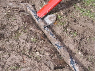 It’s not that simple. If one of a helicopter’s skids is stuck in something, it could create a pivot point. Then, when you start to lift off, the skid remains stuck. If you keep going, the entire helicopter could fly over onto its side. This is called dynamic rollover and it’s the cause of more than a few accidents. As far as I was concerned, the skid could be seriously stuck in the mud, creating a pivot point. I was not about to take off until I was sure the skid was clear of mud. So we dug. The ground was very soft and the pieces of wood we’d brought made relatively good digging tools. As we dug, we hammered pieces of wood under the skids, using rocks as hammers. Of course the trick there was to keep those pieces of wood relatively flat so they wouldn’t create pivot points. We worked on it for about an hour. We got very muddy. Our shoes kept sticking in the stuff and, more than once, my foot slipped out of my shoe when I tried to walk. (I hate when that happens.) At one point, I thought I might have to call for help — we just didn’t seem to be making the situation any better. But then we cleared most of the mud aside and I was satisfied that we’d done the best we could do.
 I could have hurried right back the airport, but since none of us were in any rush, I figured I’d take the opportunity to check out the river. We flew past Kay El Bar, which had water right up to its front lawn, and headed up the river. A number of ranches had some water flowing through their low spots. I watched some cattle cross a stream. But the most dramatic scene was at the narrow slow canyon north of town — the water was squeezing through the slot and had reached a depth of at least 20 feet. There would be no driving through the slot anytime soon.
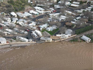 We flew over town and circled the area around the bridge. Mike got some excellent photos of the damage on Jack Burden Road — which you really couldn’t see from the ground — and the carnival right across the river. Then we headed up the river so I could show Mike how full the slot canyon was. It was raining up there, so I turned around and headed back down the river, in search of what was left of the house that had gone downstream. We hit a pretty nasty downdraft just past the bridge and since neither of us liked that, I climbed an extra 200 feet. It was a good thing I did, because when we got to the Morristown area, a helicopter flew under us, going up river. I don’t even know if he saw us. I turned around and followed him upriver, keeping some distance between us. At about that time, Don from LifeNet made a call for his departure from the airport. A moment later, I heard him on the radio again, asking the helicopter over town if it was on frequency. Although I expected the helicopter ahead of me to answer, it was Ray who replied. That meant there were four helicopters operating over town at the same time.