Another Example of the Media Screwing Up the Facts

A brief rant.

One of my Twiiter friends, @Vatsek, tweeted the following to me last night:

Have you seen this? Helicopter crashes at Texas A&M, killing one — CNN News web page

First of all, I do want to make it clear to folks that I don’t normally go out of my way to track down news stories about helicopter crashes — unless they’re local or there’s a chance I might know the pilot. But since @Vatsek tweeted it to me, I figured I’d better check it out to see why he’d flagged it. I found the article on CNN.com, “Helicopter crashes at Texas A&M, killing one.”

It was a brief piece with an overhead view of what looked like a helicopter that someone with a very large foot had stepped on. Included in the text were these sentences:

…The copter, which was heavily damaged, was attempting to take off when it crashed. A rudder apparently failed, the university statement said….

“All of the sudden, he dropped straight back down into the ground,” [a witness said]…

I have two problems with these statements:

  • A standard helicopter does not have a “rudder.” It has a tail rotor, which is controlled with anti-torque pedals. Those pedals resemble rudder pedals on an airplane, but they are not rudder pedals because a helicopter does not have a rudder.
  • If a helicopter’s tail rotor (anti-torque system) failed, the helicopter would not come “straight down.” It would be spinning like crazy. That’s because the tail rotor prevents it from spinning like crazy. If it failed, it would spin. And it’s pretty clear from the photo in the article that the helicopter was not spinning like crazy when it hit the ground.

This is yet another example of the media speculating, with absolutely no knowledge, about the cause of an accident, spreading misinformation among the public. What’s even worse about this is that if they asked any helicopter pilot — even a new student pilot — to fact check their story, they could have gotten it corrected with, at the very least, the proper terminology for the tail rotor/anti-torque system.

Exact Sunrise/Sunset Times for Pilots and Photographers

Important data…and a special offer.

This is an old post with links to old files. You can find the latest version of this offer and currently available files here.

I’m a geek and know it. Each year, for the past few years, I’ve gone through a convoluted exercise on my Mac to extract, process, and import the exact sunrise and sunset times for Wickenburg, AZ (where I live) into iCal as individual daily events. That data is then synched across all of my Macs (via MobileMe) and on my Treo (via the Missing Sync). As a result, if you ask me what time the sun rises or sets in Wickenburg any day in the current year, I can tell you — usually within about a minute — no matter where I am.

Why I Bother

Why do I have this information? Well there are two reasons.

For one, I’m a pilot and I often need to plan for flights in the future. For example, suppose a client wants me to take him from Wickenburg to Sedona for a day trip on a specific date in March. While I’m allowed to fly at night, there are three mountain ranges between Wickenburg and Sedona that get very dark at night. My personal rule, established for safety, is to leave Sedona no later than 30 minutes before sunset. That gives us plenty of time to cross all three mountain ranges before it gets dark. So, with a glance at iCal or my Treo, I can find out exactly what time sunset is on the day in question and tell him when we have to leave Sedona.

As a pilot who often flies photographers around places like Lake Powell, this becomes really handy. The best light for photography is early in the morning and late in the afternoon. This isn’t a theory at Lake Powell — it’s a fact. Knowing what time of day sunrise and sunset happen helps me to plan flights in that area.

Of course, the sunrise/sunset times at Page, AZ aren’t the same as in Wickenburg, but they’re close enough to get approximate timing for preliminary flight planning; I usually check the exact times before finalizing.

I’m also a photographer myself. So it’s important to me to know what times are best for photography.

How I Do It — Briefly

Time PaletteI get the exact time information from a program called Time Palette. I bought this try-before-you-buy program years ago. It had the information I needed, but no export capabilities. So I asked the software author to add them. He did. (Try asking Microsoft, Adobe, or Apple for a specific new feature you need in one of their programs and see how long it takes for you to get it.)

The hoops I jump through to export the monthly data and import it into iCal aren’t worth discussing here. It’s technical and boring. But each year, I improve my solution to make it a little quicker and easier for me.

Special, Limited-Time Offer

I realize that there are probably a lot of other pilots and photographers out there who could benefit from this information for their localities.

So I’m making this limited-time offer: I am willing to create iCal-compatible ICS calendar files for 2009 local sunrise, sunset, moonrise, and moonset data for anyone who asks from now until January 2009 month-end. All I need from you is the name of your city/state/country and your exact time zone name. I figure that if enough people ask, it’ll motivate me to completely automate the entire process so it’s even easier for me next year.

You can use the comment form for this post to request your custom ICS files:

  1. Enter your name (first name only is okay) in the form’s name field. Don’t put the name of your company or blog or anything else.
  2. Enter your real e-mail address in the e-mail field. This keeps it private so only I can see it. And no, I don’t harvest this information for other use or sale. But I will use it to send your files, so if you put in fake information, you won’t get the files.
  3. Enter your Web site or blog in the Web site field if desired. You don’t have to do this, but why not?
  4. In the big comment field of the form, enter the following information (1) your city/state/country, (2) the closest large city/state/country with an airport (in case your city isn’t in the Time Palette database), (3) the exact name of your time zone, (4) whether or not your city observes daylight savings time, (5) a brief summary of why you want this information, (6) the name of the ICS-compatible software you plan to use the file with, and (7) any other comments you might want to share.

Please don’t leave out any of this information. If you leave out something really important — like the location or time zone — I either won’t be able to generate the information for you or it will be wrong.

One request per person, please. Full calendar years only — no special date requests.

I will create and send out these files as I find time. I’ll probably do them in batches. Don’t nag me. Don’t complain when you don’t get yours right away. I occasionally do work for a living.

I admit that I’m more likely to be motivated to create and send out a batch of files with a donation to my coffee fund. (Hint, Hint)

Don’t use the Contact form for this blog or my e-mail address, if you happen to have it, to make a request or ask questions about how I do this. I will delete your message and will probably ignore any other request you make through proper channels. My long-standing rule has not fallen: I do not provide support via e-mail.

And if you want this information for your locality, ask for it now. I’ll stop considering requests on January 31, 2009.

Disclaimer: I do not guarantee the accuracy of this information. It should not be relied upon without independent verification for any mission-critical operations. I will not take any responsibility for any use of this information. Use it at your own risk.

Download a Previously Created File

As I create these files, I’ll put them here for download by others who live in the same city. (I won’t create files for people who don’t have the courtesy to provide an accurate e-mail address, so don’t even try it; I’ll check first.)

The following files are already available for download; help yourself if you live in one of these cities:

2009:

How to Annoy Other Helicopter Pilots

When a pilot’s attitude problem leads to safety issues.

Last week, Mike and I took my brother and sister-in-law for a day trip to a popular scenic destination here in Arizona. I’m purposely being vague here to obscure the identify of the subject of this post.

Helipad Diagram
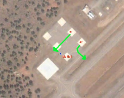
The airport we landed at has a special helicopter area that consists of a large landing pad and six parking spaces. You can see the layout in the image here, captured from Google Maps. I’ve never seen anyone use the big pad. I parked in the spot marked “My Heli.” When I touched down, all the other pads were empty, although as we walked away, an Enstrom flew in and parked at the other end of my row of pads. He was gone before we returned a few hours later.

Some Background on the Parking “Turf War”

One of the helicopter tour operators at this destination uses the pads marked #1 and #2 in the illustration. About a year before, right after they started operating, I landed at the airport and attempted to set down in my usual parking space. A pilot was spinning on #2 and asked me to park on one of the other pads. Not knowing why — but assuming he had good reason to ask — I moved over.

I later discovered that he liked to take off through the spot where I normally parked and I was in his way. That kind of pissed me off. After all, I usually come with passengers and it’s a long enough walk to the terminal. My usual spot was the safest (pointing my tail rotor away from where people were likely to be walking) and most convenient (shorter distance to the terminal). I decided that I’d park there whenever the spot was available.

Another time when I came in for a landing, the same pilot asked me again to move over. When I said I preferred to park where I was, he said he was worried about damaging my blades as he went in and out of his spot. I didn’t say what I was thinking: how bad a pilot could he be that he couldn’t avoid another helicopter on such well-spaced pads? Instead, I told him I wasn’t worried and I used my blade tie-downs before leaving the area.

When I arrived the other day, I was glad that other pilot wasn’t around to ask me to move. Just in case he was out and about, I did tie down my blades.

An Unsafe Departure

We returned to the airport after a nice hike and walked back out to the helicopter. Now there was a tour helicopter on the pad marked #1. He’d just started up and was warming up the engine with passengers on board.

On the HelipadI wanted to get some video of my helicopter sitting on the pad with the scenery behind it as a jet took off on the runway. I asked my passengers to stand by the blue X while I did this. I assumed that the helicopter on pad #1 would depart along the markings in the helipad area. That’s what we’re trained to do. That’s why there are markings there. My passengers would be well out of the pilot’s way and safe — or as safe as possible in an active helicopter landing area.

I assumed wrong. The helicopter picked up to a 10-foot hover and hovered straight out toward the opposite pad, right next to mine. (See the straight green arrow in the illustration.) It was less than 15 feet from my waiting passengers as it paused at the back edge of the pad, over concrete and dirt. Dust, small pebbles, and grass clippings went flying all over us. Then the pilot took off, leaving us to brush debris out of our hair and clothing.

I was angry. The pilot’s departure was unsafe. Not only did his unusually high hover put his own passengers at risk in the even of an engine failure, but his proximity to us was downright dangerous. There was no reason for his departure route. He could have more safely departed across pad #2 (which was empty) or behind (above in the image) pad #2.

My husband, Mike, who is also a helicopter pilot, commented on the departure immediately, calling the pilot an asshole. I couldn’t agree more.

The other company helicopter returned from a flight and landed across from mine in pad #2. My group climbed into my helicopter and I started the engine. While warming up, the helicopter on #2 changed passengers. By this time, we had headsets on and were monitoring the radio. The pilot politely asked if I was ready to go. I told him I was still warming up and that he could depart. He picked up into a hover and hovered from the pad to the taxiway (see the bent green line in the illustration) — as I assumed the other helicopter would have done — and departed.

Teaching Me a Lesson?

I was almost ready to do my mag check when the first helicopter returned. The flight couldn’t have lasted more than 8 minutes. The pilot came in on the taxiway from the northeast and asked on the radio if the “Robbie” would hold position. (The way he said “Robbie” was definitely condescending; sit a guy in a turbine helicopter and he forgets what he learned to fly in.) I told him I would remain on the pad. As he taxied in for landing — before he even touched down– he told me that if I’d park at one of the other pads, I would be out of his way and my passengers wouldn’t get dusted.

This absolutely enraged me. This was obviously the same pilot who had told me to park elsewhere in the past. Apparently, he’d purposely hovered past my passengers — my family members putting them at risk — to teach me a lesson. Now he was making sure I understood. He also very condescendingly added that they like to see out-of-town visitors, but it’s better if they park on one of the other pads.

Until this point, the parking situation had been a turf war between the tour operator’s pilots and the other helicopters who land and park at that airport. But with this incident, it became a serious safety issue. I got extremely rude to the pilot on the radio — I admit it — and, after telling him that I didn’t like him putting my passengers at risk, I said that I’d park “Any damn place I wanted.” He told me not to “cuss over the radio” and then tried to smooth it over by saying he was trying to be courteous. I told him he should be safe first.

Why?

The question I have after all of this is, why?

Why should a pilot care where other pilots park, as long as they’re not in his assigned space?

Why would a pilot purposely put people on the ground at risk to prove a point?

Why would a tour company hire a pilot with an attitude like this?

As you might guess, I didn’t let this go. I reported it to the FAA. I did it more to get the incident on record than to initiate any kind of action. If anyone else complains, I want my complaint to provide additional evidence of an ongoing problem.

The way I see it, each pilot represents all other pilots. When one pilot does something stupid and dangerous, he’s making all of us look bad. I work too hard to keep my own operations safe and trouble-free to tolerate this kind of bull from a pilot with an attitude problem.

What do you think about this? Use the comments link or form for this post to share your thoughts.

LinkedIn Groups

A wasteland of advertising.

Okay, so maybe I’m being harsh and unfair. I just watched two back-to-back episodes of House on DVD and the Hugh Laurie character’s cynicism really rubs off on me.

LinkedInBut look three of the five most recent “discussion topics” in a helicopter-related group I belonged to on LinkedIn:

ABC Helicopters in ABC Florida
We are a flight training school that operate R22, R44,Schweizer 300’s and a Jet Ranger. If you are looking to become a Commerical pilot contact us at ww.abc.com

and

I am new to this group and looking to expand my network. I offer Helicopter flight instruction, demo flights, rides and rentals.

XYZ Choppers provides flight instruction, demo flights, helicopter rides, and helicopter rentals in Robinson R22 and R44 helicopters.

XYZ Choppers LLC is a Helicopter Flight school that is dedicated to the education and understanding of Helicopter flight concepts. As a student of XYZ Choppers, you will be learning how to fly in the fist 5 minutes of in-flight instruction. From the first lesson, you are on your way to becoming a helicopter pilot. We stress education in our ground school and consistently challenge your skill as a developing helicopter pilot.

and

Residential Airport Communities / Airpark Location Ideas?

I’m currently 70% sold out of AAA Estates Airpark on Lake AAA in east TX. See http://www.AAAestates.com/
I’m very interested in locating a new airpark location/area (City/State 300-500 acres) and would love to hear some ideas. I would be interested in an area/place that has the four seasons or very close to that.

Are these people freaking kidding me? How could any of these “discussion topics” be considered discussion topics? They are blatant advertisements, plain and simple.

My understanding of “discussions” is that people share ideas and opinions about specific topics they’re all supposed be interested in. I don’t think advertisements or solicitations for “ideas” that are obviously posted to get attention for business endeavors fall into that description.

I’m already a commercial helicopter pilot. That’s why I joined the group. I have no need for entry level training or helicopter “rides.” I’m not interested in giving people advice about real estate.

I’d like to see the group turn into something of real value to commercial helicopter pilots. The ads I’ve been seeing don’t meet that criteria.

Is this the way LinkedIn is going? Are the group discussion areas becoming a Craig’s List for a specific topic?

If so, I want nothing to do with it. I have to look at enough advertising every day. I shouldn’t have to look at it when trying to network with and learn from people with similar interests. I just dropped out of both groups I joined last month. Frankly, I have a lot better ways to waste my time.

Photos from Our Flight to San Diego

The view from above.

In November, Mike and I took my helicopter to the San Diego area for business. The flights to and from San Diego were over some of the most interesting — and boring — desert terrain out there.

Our route to San Diego from Wickenburg (E25) took us southwest, skirting around the restricted area north of Yuma, where we landed for fuel. (Fuel there was $1.20/gallon cheaper than at my home base.) Then almost due west along I-8, over the Glamis Dunes and Imperial Valley, which lies below sea level. Finally, a climb over some mountains and a descent down to Gillespie Field (SEE).

On the return flight, we took a different route. We flew east along I-8, then northeast to the northern tip of the Salton Sea to Chiriaco Summit and then along I-10 to Blythe, where we refueled. (The fat guy is gone.) From there, we overflew Quartzsite before making a bee-line for Wickenburg.

You can see the approximate routes below; click the map for a larger view with readable labels.

Route of Flights

Mike’s got his private pilot certificate and 100 hours of flight time in helicopters, so he’s legal (per my insurance company) to fly passengers. So he did most of the flying. I had my door off for the Yuma to El Cajon part of the flight and took photos — mostly over the Glamis dunes. It was nice to be a passenger for a change — to be able to use my camera without left-handed contortions. I also had the POV.1 video going for part of the flight, although the sound crapped out part of the way.

Anyway, here are a few of the photos I took on the flight. You can find more of my aerial photos — as well as larger versions of these — in my photo gallery.

Glamis Sand DunesGlamis Sand Dunes

Formally known as the Algodones Dunes or the Imperial Sand Dunes Recreation Area, the Glamis Dunes is a huge series of sand dunes west of the Colorado River, northwest of Yuma, AZ in California. The dune field stretches 45 miles north to south and 6 miles east to West. This photo shows only a portion of the dunes, looking north from the I-8 area. The dunes are extremely popular for off-road vehicles; this photo was taken on a relatively quiet Friday morning.

Sand DunesSand Dunes

Here’s a closeup shot of the Algodones Dunes from the air. This shot was taken from about 500 feet above the ground, over I-8, just west of the Arizona-California border.

Desert FreewayDesert Freeway

The folks back east probably have no concept of the long distances of nothingness on a freeway that cuts through the desert. This shot of two tractor trailer trucks passing each other in the barren wasteland of the Imperial valley’s southern extremities might give them an idea.

Desert MountainsDesert Mountains

The mountains just seem to go on forever in this aerial shot of mountains in southwest Arizona, not far from Quartzsite. Lake afternoon light casts long shadows.

CAP CanalCAP Canal

The Central Arizona Project (CAP) snakes its way through the Arizona desert, bringing water from the Colorado River and its lakes to Phoenix and its suburbs. This shot was taken just north of Hope, AZ on our return flight to Wickenburg.

Forepaugh RanchForepaugh Ranch

This ranch is nestled at the base of two hills in Forepaugh, AZ, out of sight from the main road (Route 60) only a mile or so away. It reminds me of an earlier day of ranching, when remote ranches were self-sufficient homes on the range.