Chasing Desert Racers

At the Best in the Desert/BlueWater Parker 425.

I spent this past Saturday doing one of the things I really love to do: chasing racecars with a helicopter.

The venue was the Best in the Desert Racing Association’s BlueWater Resort & Casino Parker 425, which featured highly modified trucks, cars, and buggies racing on a 140+ mile dirt track through the desert. My client was a television producer who videos these events from multiple cameras and turns them in TV shows. For this event, they had a total of 15 cameras, includibut thingsng one in my helicopter and several in the trucks out on the course.

I flew the helicopter with the cameraman and my husband, Mike, working as a spotter, on board. The cameraman sat behind me with his door off. Mike sat beside me.

We started before dawn at the Parker Airport. I started up at 7 sharp and was warmed up and ready to fly by 7:15. The police escort was leading the 300+ participant vehicles to the starting line on Route 95 in downtown Parker when we began circling about 500 feet overhead. The cameraman had a list of 15 targets he needed to video. The first one was the 15th truck in line at the start. Racers were released 30 seconds apart. When our first target was released, the fun began.

Desert Racing Truck
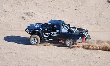
I chased the car down the paved road and onto the dirt track, descending as I left the downtown area. Soon, we were racing beside it just 70 feet up on the long straightaway that heads due east. Mike kept an eye out for wires, calling them out as he saw them. My attention was split between the truck, the wires, and the track in front of me. I worked the cyclic and collective hard, climbing, descending, slowing, speeding up. Both arms and legs worked automatically to make the helicopter do what I needed it to do. Spectators below me went by in a blur. The track made a 90 degree turn to the left and I paused at the inside of the curve just long enough to pivot so the cameraman could keep the camera on the target. Then down the short straightaway to the edge of a steep drop with high wires on one side. The truck descended the hill while I climbed over the wires. I met the truck on the other side and we raced together through a tree-filled dry wash.

“Okay, peel off,” the cameraman instructed.

I turned away from the target and followed the road back. Now we had to find the next target. All we had were numbers — we didn’t know much about how the vehicle looked, other than what class it was in. I had to fly low enough to see them. The first one of us to see a number, called it out. We got the next target halfway back to town. I lowered the collective to slow down and made a sharp 180 degree turn. Then I was on that truck, following it to the wires and into the wash.

We repeated this process about seven or eight times, each time picking up our target a little farther away on the track and ending a little farther down the track. I got to know exactly where all the wires were. Sometimes, I’d look down in time to see a spectator wave up at us or snap a photo. I think there were more photos taken of us that day than of any one racer.

This went on for over an hour.

Then, suddenly we could no longer find any of the targets we needed to video. That started a search up and down the track, flying low enough to read the numbers. Every once in a while, the cameraman would pick out a “trophy truck” or a vehicle driven by someone well-known, and ask me to follow it. I’d follow as closely as I dared, putting the cameraman close to the action. Inside the helicopter, through our noise-reduced headsets, we could sometimes hear the engines of the racers below us or the sirens of the vehicles preparing to pass. We watched one driver slip off the track and race along beside it, scattering spectators who had been standing too close. We shot some video of a modified Hummer flying through the air after a particularly bad bump.

I suppose I should mention here that I wasn’t the only helicopter at the event. There were at least five others: 2 R44s, an Astar, a Eurocopter, and a Bell Jet Ranger. In most cases, they’d been hired to follow a specific race vehicle or team. Once they left the area, they didn’t come back for a while. So keeping an eye out for aircraft wasn’t a serious issue.

After two hours, we headed back to the airport. I shut down and placed a fuel order. Then we drove over to the BlueWater Casino for breakfast. The cameraman the cameraman met with some of the folks he works with to see how many vehicles on his list were still in the race. Each vehicle had a transponder and satellite communications device so it could be tracked from headquarters at the Casino. According to the cameraman, fewer than 50% of the vehicles finish the race. Most of them break. And if you saw the track, you’d understand why.

With an updated list, we headed out again just before noon. We were expecting one of the target vehicles in the pit area, so we stayed nearby. There was a “serpentine” area just east of the airport, with winding, bumpy tracks in a big field surrounded by spectators. I think there was about 5 miles of road there, and it was so twisty that even from the air, I had trouble figuring out the route. We spent about 15 minutes there, filming the action of vehicles skidding around the sandy curves, throwing dust high up into the air. At some point, I realized that I was probably putting on a better show for the spectators than the cars and trucks were.

We spotted a target vehicle as he was leaving the pits and took off after him. More chasing at low level, avoiding wires, slowing when the truck slowed, speeding up when it speeded up. We peeled off and continued down the track, looking for more targets. That’s when we started seeing the breakdowns. Trucks and cars and buggies on the side of the road with parts peeled off of them and drivers bent over their innards. One team was changing a tire. Another was taking the hood off the car. We saw a fender alongside the track. Later, we saw a prone driver with his companion performing CPR. (The rumor I heard was the driver suffered a heart attack or stroke while driving and died on the race course. I have not been able to confirm this yet.)

Desperate to find one last vehicle on the cameraman’s list and looking for exciting footage, we followed the entire 140-mile course. It stretched from Parker through the empty desert as far east as Cunningham Pass (north of Wenden) and around Planet Peak (near the Bill Williams River) to the northwest. This much-reduced map gives you an idea of the distance — I’ve highlighted the track in light red so it’s easier to see.

Parker 425 Map

Much of the course was pretty boring from my point of view — lots of long, straight stretches. In one area, the road ran alongside a set of high tension power lines, making it tough to get low enough to see car numbers. But things got interesting on the last 4 or so miles, when the track headed into the mountains south of the Bill Williams River. The cameraman got some excellent footage of a car winding its way down a narrow canyon. I had to stay high — there wasn’t enough room for me to fly alongside it. But when the canyon opened, I dropped down so he could get some close-up shots.

After trying a few more times to find the missing buggy — we were in touch by radio with the satellite tracking people — we headed back to the airport and I shut down.

We’d flown a total of 5.0 hours. The sky had clouded up and lighting wasn’t as good as it had been earlier in the day. Although we’d planned a third flight for the finishers, the cameraman. The cameraman decided to skip it.

It had been a great day. Not only did I do a lot of flying, but it was the kind of flying I really love to do — challenging, exciting, and with a goal other than going from point A to point B.

Why can’t all my gigs be like this one?

Note: If you were at the 2008 Parker 425 in February and have photos or video footage of a plain red helicopter (no stripe) flying with the cars, please let me know. I’d love to show them off with this post or elsewhere on this site.

February 7, 2008 Update: I added a photo Mike took during the flight to give a better idea of what was going on at Parker.

How I Burned My Fingers

Simple: I did a dumb thing.

About a week ago Thurdsay, while making dinner, I burned the first three fingers on my left hand. Since then, the burns have gone through a series of nasty, ugly, painful stages. They’re healing now, though, because I finally started taking care of them.

How I burned them is an example of how relatively smart people can do seriously dumb things. In this case, I’d put about a half cup of water in a 1-cup Pyrex measuring cup and stuck the thing in the microwave to boil. I always boil water in a microwave (if one is available). I wasn’t thinking very well — there was a lot on my mind (as usual) — and hit the Minute Plus button twice. So when I removed the cup of boiling water 2 minutes later, it wasn’t just boiling — it was superheated. As I was moving it from the microwave to the counter top, I added about 1 teaspoon of beef bullion powder. The superheated water immediate boiled over the top of the cup and onto my fingers. I put the cup on the counter, shook the hot water off my hands, and proceeded to clean up the mess I’d made on the countertop, cabinets, and floor.

I didn’t realize how badly I’d been burned until much later. It hurt, of course, but I was busy doing other things and tried hard not to pay attention. Later, I bought some Bactine and kept spraying it down. The skin was red, but I didn’t think much about it.

The next day, my forefinger was blistered and puffy. My middle finger also looked pretty bad. More Bactine. I was volunteering at an equine endurance ride and I was busy. The blisters burst and reformed multiple times. (Hope I’m not grossing you out too much.) It wasn’t until the weekend was over and I really had a chance to clean up and look at my fingers that I realized how badly I’d been burned. My first two fingers probably had second degree burns.

I won’t go into more gross details about the skin on my fingers and the stages it went through. I will say that I finally started putting Neosporin (a triple-antibacterial salve, for those of you who aren’t familiar with it) on my first two fingers and wrapping them in special knuckle bandages. If I’d done that a week ago, I’d be all healed up. But I didn’t, so I’m not.

I’ll probably be almost as good as new within a few days. I suspect, however, that my forefinger will be scarred because of my stupidity. No hand modeling in my future.

Lessons learned: put containers of boiling water on the countertop before adding ingredients.

The Super Bowl is Coming!

Developments around the University of Phoenix Stadium in Glendale.

I’ve been doing flight training down at Glendale Airport for the past few weeks, working on my Instrument Rating at Silver State Helicopters. Two or three times a week, I drive or fly down there in the afternoon, spend a few hours sitting in a simulator trailer with a flight instructor, and fly or drive home.

The drive is long and boring. I found the best route though, thanks to my friends Ray and Robbie: Grand Avenue to Litchfield Road to Glendale Avenue to the airport. I can do it in just over an hour sometimes. It’s about 50 miles each way.

University of Phoenix StadiumGlendale Airport is just 3 miles or so from the University of Phoenix Stadium, where Super Bowl XLII will be held this Sunday. The other day, while waiting for the Glendale Tower controller to clear me across the runway, I overflew the stadium area. The grass was outside, looking rich and green. The top of the stadium was closed. A ferris wheel was under construction in the parking lot on the west side of the stadium and there were lots of party tents and other things going up.

The Super Bowl is apparently Glendale‘s chance at the “big time” and they’re doing everything they can to make it a big party.

At the airport, things are also changing. Glendale Aviation, which had been the FBO there for years, expanded its building and added a corporate hangar large enough to accommodate three small jets. (At least that’s how it looks to me.) It’s now called LuxAir — I guess you need a foo-foo name to attract football fans arriving by jet. Of course, since it’s the only real FBO there, there’s no competition at the airport. It’ll probably make enough money this weekend to cover the cost of the building addition and more. But it couldn’t have been timed any better; crews are probably putting on the finishing touches inside as I type this.

Last week, the ramp was completely full of small airplanes, like Cessnas and Pipers. Apparently, the guy who owns the hangars and shades evicted everyone while doing some upgrades, then raised the rents beyond what local pilots were willing to pay. Few planes went back. I guess their owners would rather roast their wings in the hot Arizona sun. But yesterday, the ramp was almost empty. They’d moved all the little planes under the shades or to the more remote parts of the ramp, leaving plenty of room for incoming jets. Even the DC3 that had been sitting there for months (if not years) had been towed to the far reaches of the airport ramp, tucked into a spot between the hangars and perimeter fence like a broken down truck in someone’s yard.

Inside the terminal, the lobby area’s furniture — a mixture of chairs and tables normally used by one of the flight schools for training and briefing — have been removed. In their place are leather chairs and tables, arranged in little chat groups. I can’t tell you how comfortable they are because I don’t know. They’ve roped the whole thing off with yellow caution tape so no one sits on them until the big money starts arriving. I’m willing to bet that next week, when I return, all that nice furniture is gone.

It’s almost as if Glendale Airport is putting on airs, like Scottsdale Airport.

Glendale Airport’s restaurant, which had been closed for months, reopened last week. It’s the same old place, but with new owners. I haven’t eaten there, so I can’t rate it. I’m sure they expect to do a good business over the weekend. Rumor has it that they’re going to do a buffet. Rumor also leads me to believe that they’re doing a buffet because they can’t deal with table service and they’re taking the easy way out.

Yesterday was my last afternoon at Glendale Airport until after the big event. I canceled Friday’s lesson so I could get an early start out to my weekend gig in Parker, AZ, chasing race vehicles around a desert racetrack with a film crew on board. Wickenburg is one of two area airports outside the 30-mile TFR (Temporary Flight Restriction) that’ll kick in around Glendale on Sunday afternoon, before the game, so even if I get back late on Sunday afternoon, I don’t have to worry about landing at my home base.

But I doubt whether Wickenburg will see the big jets. There’s plenty of room at Glendale and, thanks to the inability of Wickenburg’s Airport Consultants and Manager to plan for the future, only two jet parking spaces at Wickenburg Airport.

The above image of University of Phoenix Stadium is from Wikipedia and is licensed under Creative Commons Attribution ShareAlike 2.0 License (cc-by-sa-2.0). In short: you are free to share and make derivative works of the file under the conditions that you appropriately attribute it, and that you distribute it under this or a similar cc-by-sa license.

Dieting…Again

I really need to lose weight.

Without going into specifics, let’s just say that like the majority of Americans these days, I’m overweight. I’m tall, so I can “get away with it” — to a certain point. But I don’t want to. I want to be thinner.

Why I Want to Lose Weight

Please understand that this isn’t an appearance issue as much as its a health and practicality issue.

I had a friend who was overweight and constantly dieting. One day, she told me she didn’t care how much she weighed. She wasn’t succumbing to the pressure to be thin, just to make some man happy. (She was divorced.) So she stopped dieting and basically went to hell physically.

I don’t want to lose weight to make a man happy. My husband doesn’t seem to care that I’ve developed “love handles.” There isn’t any other man I want to impress. I’m forty-something. Those days of flirting are over.

But as I age, my weight is holding me back — almost literally. I have bad knees and the more I weigh, the more my knees hurt (or creak) when I’m walking up stairs or hills. I’ve always been short of breath when going uphill, but now it’s worse. And I can’t help but wonder how these extra pounds are affecting my overall health: heart, arteries, blood pressure. Stroke runs in my family on both sides. I don’t want to go there.

Then there’s the practicality side of the matter. Every six pounds is a gallon of fuel on my helicopter when I’m flying with a bunch of other fatties. I’ve done plenty of weight and balance calculations and I’ve realized that if you put a 250+ pounder up front with me and lightweights in the back, we’re going to be nose heavy. Being lighter would give me more flexibility with loading passengers, too.

In the spring of 2004 — just four years ago! — I weighed 30 pounds less than I do now. When I met my husband in 1983, I weighted 60 pounds less. (That was a bit on the thin side, in all honesty, but I wouldn’t mind going back there.) And for a while in college, I weighed 85 pounds less than I do now. (That was way too thin for someone my height and I was having digestive problems because of it.)

I want to go back to what I weighed in 2004. And I want to do it by March month-end.

What I’m Doing About It

Okay, so I’ve restated my “lose weight” goal as a New Year’s resolution. Big deal. I’ve been doing that for the past three years.

But now I’ve decided that I’ve really had enough. And I’ve begun watching what I eat.

You know, everyone says that Weight Watchers works. I know why. It’s because you look at every thing you eat and see the impact in terms of calories, fat, and other nutrition.

I don’t want to go to Weight Watchers, but I found an alternative. It’s a Web site called FitDay. I’d actually stumbled upon it at least a year ago, but a Twitter friend (@truecolor) mentioned it just the other day and I went to check it out again. This time, I decided to use it.

FitDay is a Web-based nutrition program, that is designed to help you meet weight and other nutrition goals. You tell it exactly what you ate and it tells you how many calories and other nutritional units you’ve consumed. You can set goals, specify additional activities (like exercise programs), and, of course, enter your daily weight. FitDay performs all kinds of calculations to tell you how your diet and exercise affect your nutrition and calorie burn.

Calorie BreakdownFitDay tracks all your data and prepares charts and graphs, like this one from the other day. I’m trying to keep my carb count low, since Atkins has worked so well for me in the past, and that’s why you’re seeing so many calories from fat. I’m going to try to shift those calories to protein. FitDay makes this relatively easy by letting you view the nutritional information from a vast database of foods.

For example, this morning I really wanted some oatmeal instead of eggs. But after consulting the FitDay database, I realized that a serving of oatmeal would put me way over my maximum goal for carbs for the day. So I stuck with a nice spinach, egg, scallion, and cheese omelet. FitDay gave me the total counts for my breakfast, which included two large cups of coffee with real sugar and 2% milk:

Today's Foods

Just seeing how each item I eat affects the overall picture of my nutrition is making me think twice about everything I eat.

So far, I’ve lost 2-1/2 pounds in 3 days. While it’s too early to make a call on whether this is working, it has to work — as long as I stick with it.

FitDay also has a PC-based application that you can buy, download, and use on a PC. I’m thinking of getting it for my mom, who has always struggled with weight. I’m not a PC user — I use a Mac — and don’t think it’s worth firing up Parallels just to track food when I can do it on the Web.

What I Think

While I’m not especially pushing FitDay — the Web-based program is far from perfect — I do think that it’s a useful tool for dieting.

What do you think? Have you tried any dieting tools that really helped you out? Share your comments here.

Some Photos from a Desert Trek

A handful of photos.

I don’t usually put a lot of large photos on this site, but I thought I’d give it a try today. Yesterday, Mike, Jack the Dog, and I went for a combination Jeep ride/hike out in the desert northeast of Wickenburg. All of these photos were taken within 15 miles of my home, so it gives you an idea of the landscape I live in.

Winter is a great time for enjoying Arizona’s Sonoran desert. Oddly enough, however, our party of seven (including Jack the Dog) didn’t run into anyone else along the way.

We started at the Rodeo Grounds on Constellation Road in Wickenburg, then headed out on Constellation Road. We made the left hand turn just before Monte Cristo Mine, followed that road for a short while and took a right where it forked off. We drove through one drag gate, closing it behind us to keep the cattle on their appropriate sides of the fence, and continued down the road. Eventually, it merged with Slim Jim Creek. We followed the dry creek bed as far as we could, maneuvering around and over two nasty places where the last flood had scattered boulders in the wash. When we reached a point where we could follow the creek no further, we pulled onto the side and parked our pickup and two Jeeps. The road continued, but there were two narrow places just beyond where we parked. Besides, it climbed away from the creek, which was our intended trail.

We geared up with drinking water, lunch bags, and cameras and headed down the creekbed on foot. I figure we walked about 1-1/2 to 2 miles. The creek wound through some of the most beautiful Sonoran Desert scenery before ending abruptly at the Hassayampa River. Although there isn’t a drop of water flowing under the bridge in town, there was quite a bit at the mouth of Slim Jim Creek.

Here are my favorite photos of the day, along with some captions.

The south-facing hills were absolutely covered with saguaro cacti.

I played with my fisheye lens here. This rock face was actually quite flat, but the lens makes it look like it curves out into the river. Not very realistic, but it looks cool.

Here’s Jack the Dog with that fisheye lens again. He found some quicksand near this spot and almost got stuck in it.

The river flowed a lot higher earlier in the week. This sand shows the pattern from the receded water. It was still quite wet.

Believe it or not, this is the skeletal remains of a type of prickly pear cactus. (We also found the decomposing body of a javelina, but I didn’t photograph it, primarily because it was really gross.)

This is the windmill near the remains of Sayer’s Station, which we passed on our way on Constellation Road. The road climbs past the windmill and I took this shot from the road, just about level with the top of the windmill. I like taking photos of windmills.

Comments? You know where to put them.