Postcards: The Sundial Bridge

My 2017/18 snowbirding vacation is officially over. Last week, Penny and hopped on a commercial flight home, took care of a bunch of chores my housesitter couldn’t do, and enjoyed the little of home luxuries like full-time electricity, a spacious shower, and a dishwasher. On Thursday morning, we climbed into my helicopter and made the first two of three legs of my annual migration to the Sacramento area for a frost control contract. The destination was Redding, CA, where the helicopter was stripped down for its annual inspection by the folks at Air Shasta.

While the helicopter was getting work done, I did some exploring. Friday found us at Turtle Bay, which is a park along the Sacramento River. There’s a kids museum there and access to miles of riverfront bike and walking trails. And the Sundial Bridge.

The Sundial Bridge is a neat little single-tower pedestrian suspension bridge over the Sacramento River. Cables from the tower, which looks like the vertical part of a sundial, collect to the bridge’s deck. It has translucent glass panels in the floor that offer a somewhat ghostly view to the river below; this walkway is set aglow at night by lighting under the bridge.

Sundial Bridge over the Sacramento River in Redding, CA.

The tower at the Sundial Bridge.

Deck of the Sundial Bridge.

Sundial Bridge deck at night.

Although I didn’t think it was a real sundial, this Wikipedia entry has informed me that it actually is; the Tower is oriented due north and there are places to read the time on the north side.

Penny and I spent about 2 hours in the area, walking on the trails and stopping for something to drink at the museum store there. The place was hopping, with plenty of pedestrians, bikers, and dog walkers. Later, when I realized we’d need a second night stay in the area, I checked into the Sheraton hotel there for a little hotel luxury; that’s when I was able to get the nighttime shot.

Snowbirding 2018 Postcards: At Buckskin Mountain State Park

The original plan for my first two days away from the Quartzsite area was to stay in Parker, AZ, at the Bluewater Casino. There’s overnight parking there, as well as a boat ramp and marina. But when I got to Parker on Thursday, I realized that it was the weekend of the big Parker 425 off-road race. I didn’t want to be anywhere near that crazy event so close to the weekend.

So I continued driving up Route 95 in the Arizona side of the river until I reached Buckskin Mountain state park. That’s where I got a campsite in the “cabana” area right on the river. The cabanas are cinderblock structures, open on front and back, with a picnic table inside and a grill outside. You back into a parking space in front of your cabana and use it as part of your site. It’s not perfect, but it does make a nice, easy place to hang out outdoors in the shade. Best of all, there’s a power outlet, so I can enjoy little luxuries like my microwave and don’t have to worry about running down the battery when I watch a DVD at night. And who could complain about a waterfront campsite?

View from my site.

On Friday morning, I took a short hike to a viewpoint overlooking the camp. That’s when I confirmed something I suspected the evening before: I’d been to this campground before. It had been about 10 years ago, when I was still married. My wasband had come with me to a two-day aerial photo gig for the Parker 425. I’d flown the helicopter while he’d driven out with my first camping trailer, a Starcraft tent camper hybrid. We spent the night at Buckskin and he’d complained — what else is new? — about all the retired guys who walked by and tried to chat him up. We’d walked up to that same viewpoint during our short stay. I know that if I looked hard enough in my archives, I’d find the photos I took there.

Buckskin Mountain State Park, from the overlook trail.

Although I’d intended on continuing along the 1-mile loop trail yesterday morning, a cool breeze started up while I was chatting with another camper at the viewpoint bench. I decided to go back to camp and do the longer hike when I was better prepared with water and a sweatshirt if I needed it.

Buckskin is a nice place to stay — if you like camping in campgrounds. There are scheduled activities, such as Friday night campfires, which I attended last night, and Saturday ranger-led hikes, which I’ll join today. There are free DVD rentals and a trading paperback library. There’s also a bookstore/gift shop. The Tuesday ice cream social, which I’ll miss, is probably a real hit with the retirees who stay here. And while it’s a shame the marina store is closed, being the only one using the dock for my boat is kind of nice.

Campfire at the park.

Snowbirding 2018 Postcards: Boating to Lunch at Parker

I’ve resumed my travels after nearly two months in southwestern Arizona and Southeastern California. The next 10 days or so will be spent making my way north along the Colorado River, with various stops in campgrounds where I can launch my little boat and get out on the water.

And that’s exactly what I did yesterday. I’ve got a riverfront campsite at Buckskin State Park north of Parker, AZ. I launched my boat yesterday morning and, after changing into shorts and a sleeveless shirt — in February! — Penny and I made the 9+ mile drive downriver to the Bluewater Casino in Parker.

The engine started rough with the usual excess of smoke but soon smoothed out and the smoke went away. I brought it up to nearly full throttle, which got me a whopping 30 miles per hour of speed. The ride down was on nearly glassy water; other than a handful of kayakers, I was the only boater out there.

The Bluewater has a huge marina with dozens of empty slips, but I pulled in at a waterfront restaurant called The Cantina, where I was able to dock right out front.

My boat docked at the Cantina on the Colorado River.

The Cantina was mostly a bar and I had low expectations of the food on the small menu. With relatively low prices, I expected small servings, too. I was wrong on both points. The smoked tri-tip on flatbread with melted mozzarella was big and tasty. I ate outside in the sun, overlooking the river and marina. I wound up taking the chili cheese fries back to camp with me; I later reheated them with dinner.

I headed back at around 1:30 PM. By that time, the restaurant was busy with newly arrived weekenders in town for the big truck race and there were more boats on the stretch of river between Parker and Buckskin. I motored back at around the same speed. Back at Buckskin, I parked at the marina dock, which was technically closed; I thought it would be easier and safer than anchoring it in the water at my campsite, especially with the changes in water levels due to dam releases upstream.

It had been my first boat outing in over a month and it felt good to be out on the water again. I’ll take it out again today and tomorrow and then move it to Lake Havasu, just upriver from Parker Dam, on Monday.

Snowbirding 2018 Postcards: Overnight At Plomosa Camp

After nearly a full month in Quartzsite, AZ, I finally hit the road.

I had waited around most of the day for a package that never arrived and finally gave up at 3 PM. I made one stop to top off my propane tanks and headed north on Route 95. Eight miles up was the turn for the BLM Plomosa 14 day camp area. I drove about a mile and a half up the paved road and then took a right. A while later, I had settled into an area where I was removed from my neighbors and had a good, unobstructed view of the sunset.

I made carne asada for dinner — I had purchased the raw, prepackaged, marinated meat at Blythe earlier in the week. It took only a minute to set up the grill and get the meat sizzling. I had a nice salad with an avocado to go with it. I ate outside, where the sun was quickly sinking toward the horizon and the very warm air was beginning to cool.

Afterward, I launched the drone. I did a live broadcast on Periscope, which is no small feat. It didn’t get many views. When I stopped the broadcast, I took a few minutes to get some aerial photos of the area, including these photos of my camp.

Aerial photo of my camp at Plomosa.

Aerial photo of my camp at Plomosa.

Sunset at my campsite.

I should mention here that if I had planned to stay more than one night, I would’ve driven further into the desert to be farther from any neighbors. As it is, I’m really not that close to other campers, although I am a bit closer to the main road than I like to be.

Tomorrow morning, I’ll get an early start and I head out to Parker, AZ. I’m in desperate need of clean clothes and the laundromat there is both clean and cheap.

If all goes well, I’ll be in my boat on the Colorado River before sunset tomorrow evening. Stay tuned.

In the meantime, it feels good to be back in the desert, away from the freeway, and on the road again.

Snowbirding 2018: Intaglio Hunting by Drone

We apparently found what we were looking for but didn’t know until much later.

Boating Trail Guide Book Cover
This little book was written for folks in kayaks and canoes, but still has good information for a shallow draft boat like my Sea Rayder.

Back in November, when I was still home planning my snowbirding trip, I stumbled upon a PDF booklet titled Colorado River Boating Trail Guide: Blythe to Imperial Dam. My little sport jet boat was already in Arizona with my camper, waiting for my return and I knew I’d be spending part of December and possibly January camping along the river. I needed destinations to explore and this little book had them.

Mohave Wash Entry
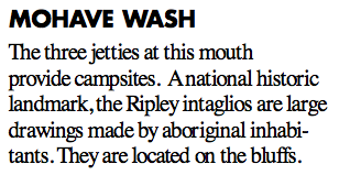
Here’s the entry for Mohave Wash. Seems pretty straightforward, no? Just boat down to the jetties.

Fast forward to December. I was camping out with my friend Janet along the Colorado River south of Ehrenberg, AZ and thumbed through a printed copy of the book that I’d brought with me. (It’s only 16 pages.), I found an interesting entry on page 6 for Mohave Wash. It mentioned the Ripley intaglios, which I’d never heard of. At the time, we were camped on one of the many backwaters at about river mile 7.5; Mohave Wash was at river mile 11.5, only four miles away. It seemed like a good destination for a test drive of my newly repaired boat.

(Yes, my boat broke on this trip. Fortunately, the problem occurred before we left the backwaters for a ride on the river and I was able to limp back to camp. Later, I got it to limp back to the boat ramp and onto the trailer for a ride to the boat shop in Blythe, which was probably pretty happy to have the business right before Christmas. It was the forward/reverse cable, but I got the throttle cable replaced, too. The boat was gone for a week and when I got it back in the water, I was very anxious to get it out on the water for testing.)

Janet, Penny, Dually (Janet’s dog), and I headed out on December 26 as soon as the water was high enough to get out of the backwaters. (The water levels varied throughout the day based on the demand for power from Parker Dam 70+ miles upstream and irrigation needs in California. The backwaters and river generally became navigable for my little boat after noon each day and remained that way until after sunset.) The throttle worked more smoothly than ever before. It was a warm, sunny day and it felt good to feel a 30 mph wind in my hair as we sped down the river at my little boat’s top speed. We kept an eye out for shallow water and found some, but the boat’s shallow draft let us glide over it.

After a while, we saw some bluffs off to the left and figured they must be the ones in the description. We began looking for the jetties.

And didn’t find them.

Maybe my idea of a “jetty” differs from the person who wrote that book. My idea of a jetty is a finger of land or rock that juts out perpendicularly (or nearly so) into a body of water. I think of the rock jetties jutting out into the Atlantic Ocean for erosion control. Or the jetties on either side of the entrance to a harbor. There was nothing even remotely resembling that along the river.

Yet here were the bluffs that the intaglios were supposed to be on top off. And we’d gone about four miles. This had to be it.

I pulled off into the shallow water on the Arizona side and we got out. It was a dumb spot; there was nothing to tie off onto. So I moved the boat to a new spot where Janet found a huge rock to tie the boat to. The water made an eddy there, so there wasn’t much chance of the boat leaving without us. We got on shore. Janet brought her fishing pole and I brought my drone.

Of course I did. I had no intention of climbing to the top of bluffs to find something I could only see from the air.

While Janet fished, I launched the drone, using my sweatshirt as a landing pad. I sent it up over the bluffs with the lens pointed straight down and studied the images it sent back to me. I took video (or thought I did), landed, swapped batteries, and took off again. On the second flight, I snapped a few photos. I didn’t see anything resembling an intaglio on screen.

Beached on the Colorado
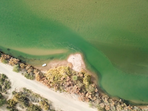
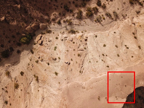
A drone’s eye view of the “jetty” (?) where we stopped along the river.

I landed the drone again and we packed up to go. The bluffs were large and it seemed that the chances of me finding anything on my two short flights was very slim. I was disappointed, but not too surprised.

We got back into the boat, cast off, and drifted back into the current. I started the engine and we went a mile or two farther down river before turning around and going back to camp. It had been a nice outing, despite my failure to find the intaglios.

Days later, I offloaded the drone images from its MicroSD card to one of the portable hard disks I use to archive my photos. I took a look at what I’d shot. That’s when I realized that I didn’t have the video camera running during that first flight so I had no visual record of it. But the photos I took during the second flight were there and I took a quick look at them.

And got a pleasant surprise.

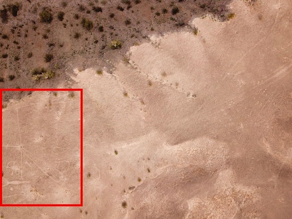
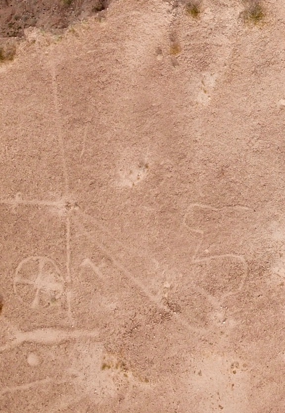
Although I didn’t see anything on the screen during the flights, the two random photos I took while over the bluffs both revealed intaglio figures.

Ripley Intaglios
I was very surprised to see the intaglios in this image. I wonder what I missed when I thought the video camera was running?

Ripley Intaglios
Here’s a closeup of that part of the image.

Ripley Intaglios
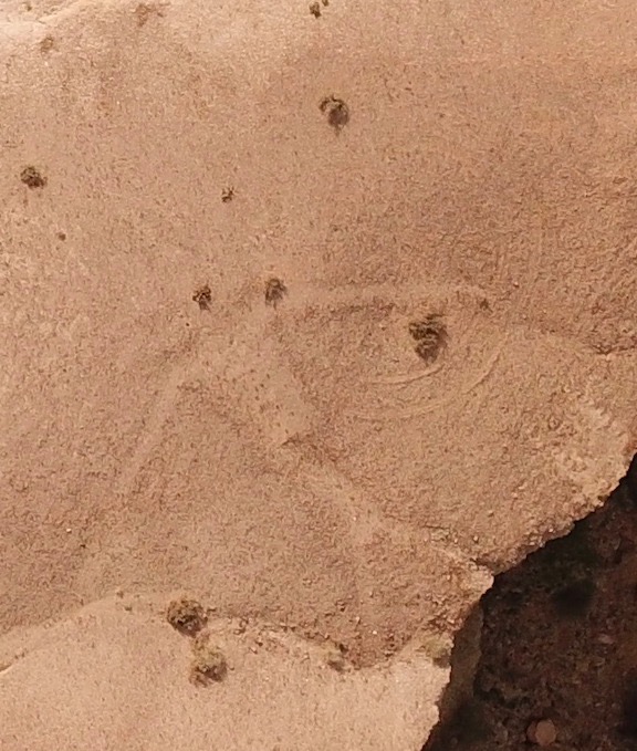
I didn’t notice the figure in this photo until I looked at it in preparation for writing this blog post.

Ripley Intaglios
Here’s a closeup. This is definitely man made. (So are the tire tracks nearby.)

Seeing that I managed to capture intaglios on both of the two images I shot while over the bluffs makes me wonder what else I missed.

Of course, I do have the GPS coordinates, so it would be easy enough to go back and explore some more. I’d probably drive, though; there is a road nearby and the bluffs aren’t that high. Seems like a good destination for next year’s trip to this part of Arizona.

If you’re interested in intaglios, be sure to check out this post: “Snowbirding 2018 Postcards: The Blythe Intaglios.”

And these are both great examples of how a drone can be used to see and capture images of things that simply can’t be appreciated from the ground.