
A few things I’ve learned during many hours of cross-country flying.
Because I take my helicopter where the work is, I often do long cross-country flights between my permanent and various temporary bases of operation. (After a lot of careful consideration, I’ve decided that it’s safer and more cost-effective to fly the helicopter from point to point than to buy a custom trailer and tow it.) I’ve been making cross-country flights in excess of 500 miles since 2004 and, for six consecutive years, made an annual round trip between the Phoenix area (where I lived) and north central Washington state (where I now live) for cherry drying work. Nowadays, I make an annual round trip between north central Washington and the Sacramento area for frost control. I flew solo on about half of these long flights; the other half was usually spent with a low-time pilot building PIC time at the controls while I tried not to be bored (or sometimes sick from PIO—long story for another time).
I flew home from California in late April. It was another solo flight, one that I’d been looking forward to mostly because I would be doing all the flying. And, instead of the 5-6 hour direct flight, I planned to fly west and then north up the California and Oregon coasts before turning inland again. Total flight time would be about 6-7 hours.
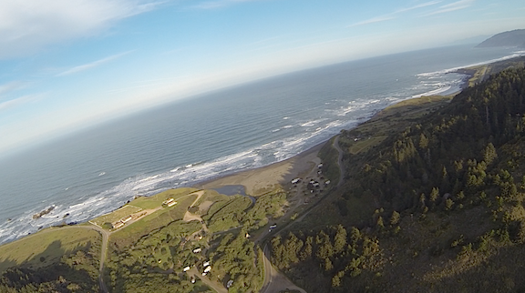
My first look at the California coast on a recent flight from the Sacramento area to Washington State.
Although the flight wasn’t as pleasant and uneventful as I’d hoped, I’m not complaining. But it did remind me of some tips I could share with other pilots preparing to do long cross-country flights.
Planning the Flight
Whether you plan to file a flight plan (which I recommend doing) or not, it’s important to plan for the flight. This pretty much goes without saying. In addition to the usual things to check in advance–weather, fuel availability, TFRs, route options–consider the following:
- Make your flight segments shorter than they have to be. Sure, Robinson Helicopter claims I can get 16 gallons per hour in my R44 so I should be able to fly 3 hours (less 20 minutes reserve) between stops. But do I really want to fly that long without a break? Probably not–especially after those first two cups of coffee. Yet I’ve seen more than a few flight plans that had us in the air as long as possible.
- Don’t just study your route before the trip—study everything around it. How many times have I tried to fly up or down the coast, only to be forced inland by a typical “marine layer” of fog? Too many to count. I’ve learned to study my route and alternate routes that would be easy to get to if I needed to change course.
- Know where the fuel is along the way. Do you think you could make a planned fuel stop if you hit 30 mph headwinds that weren’t in the forecast (or flight plan)? This happened to me on my April flight. I was lucky that there were several airports with fuel along my planned route so I could stop sooner than expected.
Preparing for the Flight
Once you’ve planned the flight, you can prepare the aircraft for conducting the flight.
- Gather and prepare your charts. If you use paper charts, mark them up with your intended route and fold them with the route easy to access. Then stack them in the order of use. That’s how I used to do it when I used paper. Sure beats fumbling around one-handed. Fortunately, we’re in the 21st century and have tools like Foreflight to provide accurate, up-to-date charts. Make sure you’ve loaded and updated all the charts you’ll need. Use the flight planning tools to mark your route. Then make sure you’re fully charged up and, if necessary, have backup power available. A backup device is handy, too. I use, in order: Foreflight on my iPad, Foreflight on my iPhone, and a panel mounted Garmin 430 GPS.
- Make an airport and frequency list. I don’t do this much anymore–Foreflight makes it easy to get this info on the fly–but when I used paper charts, I also made a list of all the airports along the way that included frequencies for CTAF (or tower) and AWOS/ASOS (or ATIS). I could then program all the airport codes into my Garmin 430 as a flight plan and make frequency changes as I flew from one airport to the next.
- Bring oil. I use W100Plus oil in my helicopter. It isn’t exactly easy to find. That’s why I usually bring along a quart for every expected fuel stop. That’s not to say that I’ll use it all, but it’s there when I need it.
- Pack snacks. I always have a small cooler on board for long flights and do my best to fill it with ice (or frozen water bottles) and good snacks before I go. Even if you planned a meal stop along the way, circumstances might prevent you from making that stop. Maybe you had to change your route. Maybe the restaurant closed 30 minutes before you arrived. Or maybe the restaurant that was supposed to be a quarter-mile south is really more than a mile and a half from the only airport gate on the north end of the field. Bringing beverages like water or Gatorade-like drinks is also important. You don’t want to get dehydrated.
- Pack an overnight bag. If you weren’t planning an overnight stay, pretend you were. A change of clothes, toothbrush, and credit card can make an unscheduled overnight stop a lot more pleasant. And if you think roughing it might be necessary, consider a sleeping bag or bedroll, either of which can make sleeping in an FBO–or the helicopter–a lot more comfortable.
- Pack an emergency kit. I’ve spent so much time flying over remote areas that I forget that many pilots don’t. My helicopter has an emergency kit under the pilot seat that includes a first aid kit and equipment like fire starters, a signal mirror, a “space blanket,” energy bars, water, and so on. If weight is a factor–and it certainly is in my R44–you’ll have to limit what you bring. But some essentials can save your life if you’re forced to land in the middle of nowhere.
- Make sure any required power supplies, cables, or batteries are handy. If you rely on electronic devices for navigation, you’d better make sure you’ve got back up power for them. My iPad’s battery can’t survive a 7-hour flight with the screen turned on and the GPS running. I use USB cables hooked up to a power supply to keep the battery charged. If you have a battery-powered GPS, make sure you have a spare set of batteries.
- Set up your tunes. I listen to music or podcasts when I fly solo. My aircraft’s intercom system automatically cuts the music sound when a radio transmission comes through. Handy.
During the Flight
It’s during the flight that your preparation will really pay off. If you’ve done everything right, you’ll be prepared for anything.
- Open your flight plan. I recommend filing and opening a flight plan for each segment of the flight. Again, with a tool like Foreflight this is very easy. I can open and close a flight plan with a few taps on my iPad screen. This beats the frustration of trying to reach Flight Service on the radio in a mountainous area when only 700 feet off the ground.
- Remember that your flight plan is not carved in stone. I can’t tell you how many flight plans prepared by pilots who were accompanying me went out the window before the second fuel stop. Stuff happens–usually related to weather–and changes are a fact of cross-country flying life. The only time I’ve ever done a long cross-country flight plan exactly as planned was on one trip from Wenatchee, WA (EAT) to Phoenix, AZ (PHX), and that’s because our straight line route across the Nevada desert didn’t have any other options for fuel stops. We had to do it as planned.
- Know when to pull the plug and wait it out. Weather an issue? While scud running is something we’ve all probably done at one time or another, it probably isn’t something we should be doing. Tired? Tired pilots make mistakes. When low visibility, severe turbulence, or simple pilot fatigue makes flying dangerous, it’s time to set the ship down and take a break. If you did all your homework before the flight, you should know whether there’s an airport nearby to make the wait a little more comfortable. I remember unplanned overnight stays in Rosamond, CA (not recommended) and Mammoth Lakes, CA (which would have been nicer if I’d been prepared for snow).
Experience Is Everything
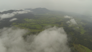
Hard to believe that only a few hours after hitting the coast I was forced inland by low clouds and rainy weather.
My April flight was a mixed bag. It started with a beautiful but slightly hazy dawn just west of Sacramento, a gorgeous morning on the coast, moderate turbulence with strong headwinds, low clouds, hazy coastal weather, drizzly rain, more low clouds, even lower clouds (and scud running), and bumpy air on a cloudy day. If you’re interested in details, you can read about it in my blog. Although it isn’t common, it is possible for me to have a perfectly uneventful cross-country flight of 500 miles or more in a day.
If you do enough long cross-country flights, planning and conducting a flight becomes second nature. I’m always thinking about what’s up ahead and working on ways to get more information about alternative routes when things aren’t looking as good as you want them to. I’ve occasionally used my phone to call AWOS and ATIS systems at airports I think might be along a better route. I use radar in Foreflight to get a feel for how weather is moving and where it might be better or worse than I am. I’ll change altitude to avoid mechanical turbulence. If I have to do any scud running, I do it slowly and carefully, always aware of exactly where I am and where I can go if things get worse.
It’s all about planning and preparing and using your experience to handle unexpected situations as they come up. After a while, there’s very little than can surprise you.
Discover more from An Eclectic Mind
Subscribe to get the latest posts sent to your email.
Just a quick note- on your trip to Arizona this winter, remember to try and stop in Hawthorne, NV. I really think you would enjoy meeting the Airport Official Greeter, Betty Easley. She is an amazing woman who does so much to promote aviation in that area. I’ll give her a heads-up if you decide to go. Hawthorne is like stepping back 50 years. Interesting place- the Army Storage Depot for years. They stored a lot of the nerve gas used in World War 2.
I wouldn’t miss Hawthorne after all you’ve told me about Betty.
All good advice ‘though I’m not sure I would want to listen to music even if I had that facility.
Had my own completely avoidable fuel crisis after a long cross country in an MT03. (Runs on MOGAS). At max weight we calculated that we might need to take on some extra fuel on the home leg. A friend said he had 4 jerry cans of premium unleaded in a caravan at Little Rissington, a former USAF base, then disused. We landed there, found the caravan and the hidden key. But the cans were empty. Durr! Not a soul around.
We measured the tank (fuel gauge was too imprecise) and calculated that if we went straight back home through Brize Norton (RAF airspace) we could just squeak in. Asked Brize radar for permission to cross and told this would be OK. Alas, a C-17 Globemaster was returning from Afghanistan with some coffins on board. They had Priority. We were held for ten minutes going round in circles, watching the massive heavy-lifter slip beneath us on finals. Our reserve was fast disappearing, and yes, we had a strong headwind when eventually we took up our final heading.
When we landed we had less than a pint of fuel left. Pure idiocy and more luck than we deserved.
That sounds scary. I had a controller put me in a traffic pattern once when I was low on fuel. I told him I had a low fuel light (no lie!) and he let me come in direct to the ramp. Even held all the other traffic for me. Seems to me that although we should honor our fallen soldiers, breathing bodies should have priority over dead ones in a situation like you describe. Just a thought.