Cross-Country by Helicopter: E25 to BFI

14.4 Hours over four states.

Cross-Country, Defined
For those of you who are not pilots, allow me to explain the term cross-country as used by a pilot. A cross-country flight is basically any long flight with a landing a certain minimum distance from your starting point. For airplane pilots, it’s at least 50 miles. For helicopter pilots, it’s at least 25 miles. So while this blog entry discusses a very long cross-country flight, we did not fly all the way across the country.

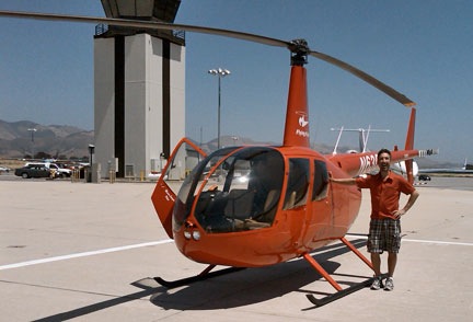
This past Thursday and Friday, I flew by helicopter with two other helicopter pilots, Ryan and Bryan, from Wickenburg, AZ to Boeing Field in Seattle. Bryan and Ryan did just about all of the flying. I sat up front being a nervous passenger when we were near the ground and playing with the radio and GPS. Brian let me make most of his radio calls on the first day, but I didn’t get to do much of that the second day.

It was a mutually beneficial journey. I needed to get the helicopter from Arizona to Washington State. Ryan and Bryan were both CFIs who wanted to build time in an R44 helicopter. It was way cheaper for them to fly with me on this trip than to rent an R44 from a flight school. There was also the added experience of planning and executing a flight through unknown terrain, with fuel stops and an overnight stop along the way. And the money they paid to fly my aircraft helped me cover the cost of this very long and very expensive helicopter flight. Win-win.

Corona Fuel

A very cool but very helicopter-unfriendly fuel island at Corona Airport in California.

Our flight path took us west, with Bryan at the controls, along state route 60 to I-10, across the Colorado River, and then along I-10 through Bythe, Chiriaco Summit, Palm Springs, and Banning; then back on 60 past March to Riverside on the 91. We stopped at Corona for fuel at what’s likely the coolest but most helicopter-unfriendly fuel island in the world. (We didn’t notice the separate fuel island more suitable for helicopters until we’d stopped and shut down.)

Here’s a video of our transition along the California coast through the LAX airspace on the Shoreline transition route. You might want to turn down the sound while playing it; lots of helicopter noise.

Then Ryan took us west on 91 through the airspace for Fullerton and Long Beach, with a Torrance low pass. (Robinson has entirely too many helicopters waiting for owners on its ramp and in its delivery room.) He then got clearance for the Shoreline helicopter transition of LAX space, which requires the pilot to drop to 150 feet 1/4 mile offshore to pass under LAX departing traffic. We continued following the coast up past Santa Monica, Pacific Palisades, Malibu, Oxnard, Ventura, and Santa Barbara. By then, the marine layer was moving in, so we went inland for a bit. Eventually, we reached San Luis Obispo (and the chatty controller) and stopped for fuel and lunch.

Ryan at San Luis Obispo

Here’s Ryan on the ramp at San Luis Obispo before departure northbound. I shot this one with my Blackberry’s camera, so pardon the quality.

Bryan was back at the controls for our departure northbound. After a very close call with a large bird, we followed the path of Route 101 northbound. Most of the route was up a riverbed in a very pleasant valley. We got to Salinas and realized that any coastal route would be out of the question — the marine layer was creeping in even there. So we headed over the mountains, eventually ending up in the western part of California’s Central Valley. We stopped for fuel at Byron.

Ryan took over and we continued north over Rio Vista and Yolo, finally hooking up with I-5. We followed that through endless farmland — much of it flooded for a crop that apparently needs lots of water — over Willows Glen and Red Bluff, with more than a few crop-dusters flying nearby at altitudes far below ours. We stopped for the night at Redding, tied down the helicopter, and got a hotel shuttle into town.

We’d flown 8.8 hours.

Ryan Flying Near Mt. Shasta

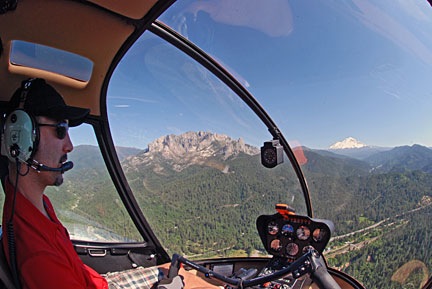
Ryan at the controls as we near Mt. Shasta in northern California.

The next morning, we were back at the airport at 9 AM, preflighting and getting ready to go. Ryan would start the flight. We headed north along I-5, over Lake Shasta and past Mount Shasta, which was snow-covered and beautiful. We were now past Central Valley’s vast farmland and up in the mountains. We flew past Weed, Siskiyou Co., Rogue Valley/Medford, and Grant’s Pass. Much of this flying was in canyons, along the same route as I-5 and a train line.

Things turned a bit iffy as I-5 swung to the east. We were hoping to go north and catch it on the other side of some mountains, shortening our route a bit, but clouds sitting on the tops of those mountains made that a bit uncertain. So we dropped altitude, slowed down, and followed I-5. Ryan flew while Bryan and I kept a sharp lookout for the power lines we knew — from both chart and GPS — were ahead. We weren’t that low and there wasn’t any real danger, but we were certainly not coming out of that canyon anywhere except the I-5 corridor. We passed the powerlines with plenty of room. The road descended into a valley and we stayed up beneath the cloud bottoms. Eventually, the sky cleared. We continued along I-5 past Myrtle Creek and Roseburg and stopped at Cottage Grove State for fuel and lunch.

Then it was Bryan’s turn again. We continued up I-5 past Hobby, Albany Municipal, and McNary. Then we headed northwest over Sportsman’s, Hillsboro, and Scappoose. We crossed the Columbia River and headed north on I-5 again over Kelso Longview and Olympia, with nice views of Mount St. Helens and Mount Rainier in the distance. Then on to Bremmerton, where we stopped for fuel. We probably had enough to make the last 20 minutes, but why take chances?

At BFI

Zero-Mike-Lima on the ramp at BFI. Another Blackberry photo. And yes, that’s Mt. Rainier in the background.

I flew the last leg with Bryan up front to handle the radio and give me directions. It was only a 15-minute flight, but the airspace was complicated, so I was grateful for the help. I set the helicopter down sloppily in the parking area. We’d flown a total of 14.4 hours.

It was a great flight. We saw so much that most of it is just a blur in my mind. With luck, these photos and videos will help me remember the trip for a long time to come.

Many thanks to Ryan and Bryan for accompanying me on this trip. I hope they learned a lot about cross-country flying.

Photos from My Trip: Day 1, Part 2

Some more shots.

I’m not sure if I can keep up the pace, but I’ll sure give it a try.

This evening, I went down to Uptown Sedona to check out a few possible hotels for future use. I’m glad I did. The Orchard Inn apparently took over the motel units for Los Abrigados, which I was recommending. This is a good thing. I takes away any uncertainty about room availability. And the hotel is nice, so I’m going to be pushing it to my guests.

Sunset Crowds
Every evening at sunset, a crowd gathers at Airport Mesa’s overlook to watch the sun set.

After a martini at an outdoor bar, I headed back up to Airport Mesa to take some photos. I wanted to stop at the parking area about 1/3 up the mesa, but it was full. So I went up to Sky Ranch, parked by my room, and walked out to the public overlook. The place was crowded. The reason: one of the best sunset views in Sedona:

Sunset on the Red Rocks
Not too shabby a view.

I didn’t stay for the whole show. After a while, the light just gets too dim to get any interesting photos. Instead, I dropped off my camera equipment in my room, hopped in the car, and headed back down the mesa for some Chinese food. There’s a restaurant in a shopping center that has Chinese and Japanese food. I was going to get take-out and bring it back to my motel room, but I heard Pink Floyd from the bar and it sucked me right in. The bartender — who looked remarkably like my friend, Rod — had a David Gilmour DVD playing on a big screen. I took a seat right in front of it, ordered a cold sake, and settled down for dinner there.

It was a nice dinner.

Night Shot
I like photographing lights at night. This might not be a good example, but it does give you a taste of what I’m after.

Afterward, I came back up to Airport Mesa and fooled around with some night photography. There was a nice crescent moon, but without a cable release, I was having a heck of a time getting a good shot of it. So I settled for some lights at night photos, like the one shown here of the Sky Ranch sign.

Then I headed back into my room for a phone call home and a quick blog entry to bring my day up to date.

Tomorrow is the Grand Canyon. I hope I can find a different spot for shooting some photos.

Photos from My Trip: Day 1

An afternoon on Airport Mesa.

I’m in Sedona, relaxing in my room at Sedona Sky Ranch. It’s the first day of my Southwest Circle Helicopter Adventure. I left Falcon Field in Mesa, AZ (near Phoenix) at 10 AM with two passengers, their luggage, and my luggage. We had a great scenic flight through downtown Phoenix, up past Lake Pleasant and the Indian ruins atop Indian Mesa, over Black Canyon City and Arcosante near Cordes Junction, past the cliffside town of Jerome, and along the red rock cliffs to Sedona. Our total flight time was around 70 minutes.

Once in Sedona, I got our rental car and took my passengers down to Uptown Sedona for the day. It was around noon and they had a Jeep tour scheduled for 3 PM. That gave them plenty of time for lunch and shopping in town. After dropping them off, I took care of some business at the Jeep tour company, grabbed a salad to go at Wildflower Bakery, and headed back to the airport to button up the helicopter for the night.

Zero Mike Lima at Sedona
Zero Mike Lima parked at Sedona. The white stuff in the sky is mostly smoke from a burn up on the Mogollon Rim.

“Buttoning up” the helicopter consists of tying down the blades in case it gets windy — don’t want the blades flopping around — doing a post-flight check, adding some oil, cleaning the windows, and locking up. I hitched a ride out to the helicopter with the fuel guy so I wouldn’t have to walk or bother someone to open the gate. I like the fuel folks here. They’re friendly and they give me a little discount. I topped off both tanks. I like to say that the only time you can have too much fuel is if you’ve got fatties on board (which I don’t) or you’re on fire.

I ate lunch out in front of the airport terminal on a bench, sheltered from much of the wind. Then I fetched my camera and spent some time taking photos like the one above. Afterwards, I checked in to the hotel. We’re staying at Sedona Sky Ranch, which is on Airport Mesa. I managed to get an upgrade for my passenger’s room so they’d have a full view. My room is one of the garden rooms.

View from Sky Ranch
This is the view from the lookout point adjacent to Sky Ranch Lodge’s Red Rock View rooms.

Sky Ranch Lodge, which I wrote about in detail here, is a weird little place. It’s at the edge of the mesa and the rooms looking out to the north have amazing views from their semi private patios. The only reason I’m not recommending it so strongly to my passengers is the simple fact that the rooms could use some “freshening.” (This is a word a friend used when I brought her here.) It’s not that they’re dirty or unpleasant in that respect — it’s just that they could really benefit from some new mattresses and linens. Some of the rooms have a downright 70s motel look about them. An investment of about $500 per room would make all the difference in the world.

But you really can’t beat the view. And it’s so much nicer and quieter up here.

The Gardens at Sky Ranch
Part of the garden area at Sky Ranch Lodge.

My room is one of the garden rooms. The grounds here are beautiful and immaculately kept, with little streams and goldfish ponds under shady trees, surrounded by flowering bushes. Very pleasant. I’m thinking of grabbing my book later on and relaxing by some of that running water. Or maybe trying out the hot tub, which isn’t far from my room.

After dropping off my passengers in town, I had the rest of the afternoon to myself. Although there was a slight chance my passengers could call for a lift back up to Airport Mesa, I have a feeling they’ll just ask the Jeep tour people to bring them up. They’re on their own until tomorrow morning. We need to be back at the helicopter by 9 AM to arrive at Grand Canyon Airport by 10:30. They have a helicopter tour with Maverick before we head into the park for our next overnight stay.

As for me, I’ll probably head back down the mesa for dinner. I want to check out some of the hotels down there. I’m looking for another affordable but well-kept lodge in town to offer my Southwest Circle guests.

I’ll also likely enjoy the sunset from either the trail northeast of Airport Mesa or the lookout area on the mesa. We’ll see. I have more than 2 hours to plan that out.

And maybe I’ll get ambitious and upload some more photos.

On Someone Else’s Vacation (Again)

I prepare to begin a 6-day helicopter excursion with two paying passengers.

Those of you who have been following my blog might remember that Flying M Air’s Southwest Circle Helicopter Adventure was featured in Arizona Highways, one of the best magazines about Arizona. Arizona Highways shares well-researched information and incredible photographs about the state, offering residents and regular visitors a guide to little-known places while enticing other folks to come for a visit or a more substantial vacation.

The magazine is well-known in Arizona but less known outside the state — except by photographers. Its photos form a sort of “gold standard” for southwest landscape photography. It also has a huge readership in Europe. Europeans — notably Germans and the French — love the U.S. Southwest, probably because it’s so different from anything out there.

Anyway, the magazine coverage got my phone ringing more than usual with people who were serious about flying with me. I sold several excursion packages, including one that begins today.

So starting in a few hours, I’ll be taking two folks from the high country on the east side of Arizona on a six-day, five-night helicopter excursion all over northern Arizona.

If you’re interested in such things, you can track our progress two ways:

  • Spot Messenger will be enabled during all flight segments. Visit http://tinyurl.com/FindMaria to see where we’re flying.
  • GPS Tracker, in my new Blackberry Storm, will be sending out signals of where I am every five minutes (while it is within cell phone coverage areas). Visit http://tinyurl.com/FindMaria2 to see where I am.

When he heard about these excursions, a fellow helicopter pilot commented to me that I’d really have to like the people I was flying around to spend six days with them. Well, that isn’t entirely true. I only spend about 1-2 hours a day with them. The rest of the time, they’re on tours (without me) and on their own. But, in general, the folks who do this excursion are very likable. After all, they like helicopters and they like touring Arizona. We’ve already got that in common, so we’re good to go.

I brought my still and video cameras with me on this trip and hope to share some images in daily blog posts. While my passengers are doing their thing, I’m doing mine. I have chores — tying down the helicopter’s blades, seeing to fuel, hauling luggage, checking in/out of hotels — but I have just as much free time at the destinations as my passengers do. I intend to make the most of it.

And get a little R&R when I’m done.

Just because I’m on someone else’s vacation doesn’t mean it can’t be my vacation, too.

Too Much to Do, Too Little Time

And a check ride report.

I realized this morning that I never did report on my check ride. When I mentioned that I was prepping for it, I promised a report the next day. That was a week ago.

In my defense, I’ve been unreasonably busy. Here’s a rundown of how I spent the past seven days.:

Friday I’ve Got Flying on My Mind

On Friday morning, I took my Part 135 check ride with an FAA examiner. It was a non-event. I didn’t fly as well as I wanted to — I guess having an FAA inspector sitting next to you while you’re flying and wondering what he was going to do to play with your head (think pulling circuit breakers, chopping the throttle, etc.) is enough to make me a nervous wreck. But I flew good enough. And once I realized the test part was over, I actually flew very well. I want to write more about this, but don’t have the time right now.

When it was over and I put the helicopter away, I had to start prepping for another round of house guests. I ran around like a nut, taking care of errands and prepping my office for use as a second guest room. I was still at it when my husband arrived with the house guests: his mother and her friend.

Saturday at Buckeye

Saturday was our big annual Buckeye gig. This was our fifth year at the Buckeye Air Fair and I hope I can do it for 15 years. I enjoy it so much. I do cheap helicopter rides priced low enough that folks can (and do) bring their kids. I think I flew just as many kids under 15 as I did adults. One flight was just three kids aged maybe 4 to 7. It was nonstop flying from 9:30 AM, when the first takers climbed on board to 3:15 PM, a full hour and a quarter after the end of the event. I had to shut down once for fuel and a bathroom break, but I didn’t even get much to eat.

I wanted to write about that, too — especially about the flight down from Wickenburg — but I just haven’t had time. Now the memories aren’t quite as fresh and I don’t think I could write something interesting about it.

Sunday’s Road Trip, with Helicopters and Big Band Music

On Sunday, I was on the road at 7:15 AM, heading west in my little Honda S2000. Road trip. I had to go to Ventura for a week for work, but I wanted to stop at Anaheim on the way to check out Heli Expo.

HeliExpoThe show was at least three times the size of the last one I’d gone to, which was back in 2004 in Las Vegas. It was like a candy store for rotor-heads like me, with millions of dollars in hardware sitting out on plush carpeting for us to caress and drool over. And climb on board to sit in cockpits. I didn’t take many pictures — it was just to damn crowded.

One of the highlights was meeting a Twitter friend, Keith Gill. Keith flies the big iron — including Air Cranes — all over the world. He’d just come in from a firefighting gig in Australia and was prepping for another gig somewhere else. Keith writes a blog called “Helicopter Pilot, Will Travel” with lots of great, real-life stories about his flying and travel experiences. I highly recommend it for anyone interested in what being a helicopter pilot is all about.

Another highlight was meeting Dennis Raubenheimer of HeliNews. I’d written an article for them at it appeared in the current issue. He had two copies for me and I eagerly opened one as soon as I had it in my hot little hands. I was thrilled to see that they’d used all of the photos I sent, many of which featured my helicopter. My only regret is that the magazine is based in Australia and few U.S. pilots (or helicopter operators interested in hiring pilots) would see it. Can’t wait to hand off a copy to Ed, my local mechanic, who is featured in a bunch of the photos.

After leaving the show at 5 PM, I took a roundabout route up to Burbank, successfully avoiding any Oscars traffic in the Hollywood area. I was meeting another Twitter friend, SaxDiva (Leanne), for the first time. She’s a college professor who teaches business by day and plays saxophone and other woodwind instruments in the evening. She was doing a big band gig at a Burbank restaurant called Victorio’s. I’d been wanting to meet her for a while and we finally connected. Another friend of mine, Deb Shadovitz, joined me for dinner. Leanne sat with us between sets and we got to meet a bunch of the other band members, including a singer who sounded an awful lot like Tony Bennett. There’s nothing quite like good food and good music at the end of the day. If you live in the Burbank, CA area, I highly recommend Victorio’s on a Sunday evening for a casual night out with live music and dancing.

From there, it was a nightime drive to Ventura. I only made one wrong turn getting on the freeway. I was in my room, 400+ road miles from home, ready to pass out, by 10:15 PM.

Talk about a long day.

Monday, Tuesday, Wednesday: Work, Work, Work

I spent much of the first three days of the week in a soundproofed booth, recording a new video for Lynda.com. The rooms are like isolation chambers that completely shut out the sound from outside them. The work is pretty basic, but often frustrating as I trip over my own tongue to get the words out. I’m not really at liberty to say what the course is about yet — I’d rather keep it a surprise to the folks who don’t already know. (No spoilers in the comments, please!)

We did the live action footage yesterday. That’s when I get dolled up with makeup, etc. and talk to a camera. I was fumbling through the takes and was starting to think I’d never get it right when I absolutely nailed the last one. What a relief!

The Week’s Not Over

The week has two more days left in it and I’ll be working in Ventura both days. I think I’ll need both of them to get the material recorded. If I finish before noon on Friday, I’ll drive home. If I finish after 3 on Friday, I’ll spend the night here again. If I finish sometime between noon and 3, I’ll make a decision then.

At home, Mike is entertaining our house guests. They leave on Monday. I have nothing scheduled next week, but I know I’ll be doing at least one flight, probably to Sedona. I already have a flight booked for the week after that, too.

Too much to do. Too little time. It seems to be the story of my life.

I need a vacation!