We wander through a mill site, fly over an open pit mine, get a hamburger in the middle of nowhere, and see the “land now” light four miles short of home.
It all started over a year ago. I discovered the beauty of the Santa Maria River from the air.
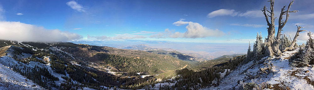
The canyon east of route 93 is unbelievably beautiful, with dramatic rock formations, cacti, and a river with real water in it. Part of the canyon is in the Arrastra Wilderness and I generally avoid it. But most of it is open to the flying public (so to speak) and I occasionally fly through it, following the winding canyon from Alamo Lake to 93.
On my flights, I’ve always noticed the remains of some kind of mining site at the end of a road not far from 93. There was some kind of shack there, what appeared to be a metal tank, and some tailings piles. Among all that was what appeared, from the air, to be a good landing zone. I thought about what a neat place it might be to take passengers or even to set up a base camp for hiking the area over a period of several days. But the road that wound through the desert from 93 to the site made it less than perfect. After all, why take a helicopter to a camp when you can hop in a Jeep and do it for a lot less money?
Time passed. Then, on Thursday, I got a call from a man named Bobby who wanted me to take him and his wife to see some ranch land he owned on the Santa Maria River from the air.
You can probably guess where this is going. The “ranch land” was the mill site I’d seen from the air.
According to Bobby, the site is named Waters Sunset Mine. I spent a good part of this morning — my usual blogging time, in fact — trying to research the site. What I came up with was the Waters/Sunset Mill and Mine, which was purchased by Orex Corporation back in 1999. This kind of jived with what Bobby had told me: that he’d sold the land to a mining company and they’d gone bust so he’d gotten the land back. There was 46 acres of this land, right on the Santa Maria River, and he owned both the land and the corresponding water rights, which he said were now worth more than the land.
It turns out, the road to the mine is not passable, partly because the Santa Maria River, which is running pretty good right now, runs right through it. There’s only one road in. So it’s impossible to get there by wheeled vehicle (unless it’s amphibious). Bobby didn’t want to land there — which is a good thing, since I’m still not legal to land with paying passengers. He just wanted to photograph it from the air. So the job was an aerial photography/survey job rather than a sightseeing tour.
After he shot his pictures and we moved on to another site to photography, we talked about the site. I told him my ideas about using the land. I told him that I’d rather use private land than public land because it’s easier to get permission. He said that he’d give me permission to use the land. I told him that if I used the land for paying customers, I’d pay him a fee per customer I brought there. He liked that idea. I think he saw it as a way to make a few bucks off some otherwise useless land.
That was Friday. This morning — Saturday — Mike and I decided to go check it out from the ground. We called John and Lorna and they were interested in coming along. So at 10:00 AM, I lifted off from Wickenburg in Zero-Mike-Lima with all four seats full for the 41-mile flight to the mill site. We followed 93 most of the way, drifting to the west when we saw the rock formation known as Shiprock. (No, this isn’t the big Shiprock near the Four Corners area. It’s a much smaller, differently-shaped version.)
 We overflew the site and I set up to land, coming up the canyon from downstream. There were two big, apparently flat areas to choose from. The first choice was not a good one; the landing zone wasn’t flat enough and the helicopter rocked a bit on its skids when I set down. I don’t like that, so I tried another spot. It wasn’t until I set down the fifth time, in another big, clear area that I was satisfied. I shut it down and we got out to explore.
There isn’t much at the site in the way of ruins. There are some nicely preserved rock foundations and a weird metal shed. There are also hundreds — if not thousands — of core samples that were once neatly piled in wooden boxes alongside a big rock formation. The wood has rotted considerably and the boxes, in some places, have fallen over.
We spent nearly two hours there, walking among the ruins and trying to identify what the things we saw were for. We also spent quite a bit of time along the river. I’d been worried, at first, that we’d be able to hear the traffic on 93. After all, it was only a mile or two upstream. But the sound of the water drowned out any other sounds. Even when we hiked up the road to the top of a hill where the sound of the water was much fainter, there was no car sound. That made me happy. It’s hard to sell a place as “wilderness” when you can hear cars on a highway nearby.
 The river was beautiful, flowing swiftly over rocks and sand. There were a number of very nice beaches (if that’s the right word) that would have been wonderful for sunning yourself or even swimming. And the sand just below the water’s surface absolutely sparkled with mica — or was that gold? I think I’ll have to bring a gold pan the next time I fly out.
I asked John, Lorna, and Mike if they thought the site would make an interesting day trip for passengers. They all agreed that it would. Then I asked if they thought it would work for overnight camping trips. They said it would be great for camping. Lots of level places to pitch tents, plenty of water nearby, and wonderful, peaceful scenery.
Heck, I’m sold.
We climbed back into the helicopter at about 12:30, now hungry for lunch. I didn’t expect us to be there so long, so we didn’t bring any food. We decided to hit the Wayside Inn near Alamo Lake for some of their excellent hamburgers. But first, we’d swing past Bagdad so I could show John and Lorna the mine there.
Bagdad is a mining town about 60 miles northwest of Wickenburg, about 15 miles off route 93. Its main feature is an open pit copper mine and that’s what pretty much supports the whole town. Unfortunately, I didn’t have my camera out when we flew over the mine — it’s quite a site to behold from the air! John and Lorna were suitably impressed. I think they’d been expecting the usual mine shaft that we can often see from the air. But this was a big pit with huge dump trucks hauling ore out, even on a Saturday afternoon. I flew past the leeching ponds and descended down into the canyon. We followed that to Kaiser Canyon, where I pointed out the hot spring far below us, then followed Burro Creek to the Big Sandy Wash and followed that to Alamo Lake.
The lake is high because of all the rain we’d been having. So high, in fact, that the road that runs across its eastern end is under 16 feet of water. (I know that because our waitress told us. She also said she caught a huge bass there the other day.) I headed out toward the Wayside Inn, which is southeast of the lake and, because we had a tailwind, flew past and circled around to land into the wind. I set down on a triangle of land at the crossroads there, right across the road from the campground. I kicked up a bunch of dust, but no one complained. I shut down and we went in for lunch.
(I’m sure I’ve covered the Wayside Inn in another blog post. Let me look it up so you can read about it….ah, here it is.)
The waitress remembered me from the last time I’d been in. “That’s a different helicopter from last time,” she said.
“Yeah, I added water and it grew,” I told her. That had become the joke that all my helicopter friends were using. “I wish it was that easy,” I added.
We ordered lunch, admiring the photos of the fish caught in the nearby lake. Some of the fish were quite large. There were dated Polaroids of dozens of them, held up by the people who’d caught them, on the wall near our table. Each photo included the date and the weight of the fish. The newest photos were only two days old. When the burgers were history, I helped myself to desert: a Schwans ice cream sundae cup. It was exactly the right kind of desert for a meal in the middle of nowhere.
It was about 2:00 PM when we headed home. When I started up, I realized that we were a bit lower on fuel than I thought we were. But as we gained speed, heading straight back to Wickenburg, the GPS told us we’d be there in less than 15 minutes. Surely I had enough fuel to make it back. Although my smaller, aux tank was on E, the main tank showed about 7 or 8 gallons. I remembered how I’d occasionally get both of Three-Niner-Lima’s gauges down to E without the Low Fuel (AKA Land Now) light going on. It certainly looked as if I’d have enough fuel to make it back.
I almost did.
We were about four miles out of Wickenburg when the Low Fuel light started to flicker. It went on, then off, then on, then off. Then on. According to my gauges, I still had about 1/8 left in the main. But I remembered what they’d taught us in the Robinson Factory Safety Course: trust the light, not your gauges. To me, the light meant “Land Now.” So I landed. On a dirt road. In the desert. At least a mile from pavement.
You have to understand that if I did run out of fuel, there was only one way down and it was the fast way. I much preferred taking my time about the landing, picking a spot when I still had enough fuel to get me there with the engine running. So I landed even when I may have had enough fuel to make it back to Wickenburg. After all, I might not have had enough fuel to make it back and then things could have gotten ugly.
Mike volunteered to walk to 60 and hitch a ride back to the airport. He started walking and I started making phone calls. I got Gus on the phone and told him where the fuel cans were. He wanted to know how far out we were. I didn’t really know how far out we were on 60. I gave him Mike’s cell phone number.
Then I saw a helicopter off in the distance. Could it be? I got in, flicked the master switch, turned on the radio, and put on my headset. I keyed my mike. “Ray? Is that you?”
“Yeah, what’s up, Maria? Where are you?”
“We ran out of gas about four miles short of the airport.”
“Got a fuel light?” he wanted to know.
“Yeah. I’m not taking chances.”
He flew by a few minutes later. Then I asked him to fetch us some fuel from the airport to save Gus a ride. Gus heard me on the radio and he and Ray made arrangements. I turned off the radio and called Mike. It was a good thing I did. True to form, he’d decided to bushwhack through the desert, thinking he’d take a shorter route back to pavement. But rather than bushwhack on a route that went more southbound (correct) he was going more westbound (incorrect). As we later pointed out to him, if he’d stayed on his track, he’d have walked an extra mile or so before reaching the road. Next time, I’m going to give him a compass. I had one under the back seat.
 Ray landed in a nice grassy area not long after Mike returned. We got the two fuel cans out of the back of his helicopter — he still doesn’t have seats back there — and he took off. Then Mike and John poured the 10.7 gallons of fuel into the helicopter. When I started up and looked at my gauges, I saw that we now had more fuel than when we’d left the Wayside Inn.
We flew back to Wickenburg and I landed at the pumps. Earl, who was on duty there, topped both of them off. We parked outside — I’m flying again tomorrow. Gus came by and made some jokes about me running out of fuel. I realized that I’d be getting ribbed about it for a long time to come.
We all had a great time, though, and I don’t mind the ribbing.
 We’d done it before, perhaps ten years ago. It had been a Christmas present for Mike. A two-night mule trip to Phantom Ranch at the bottom of the Grand Canyon. This time, we did it with John and Lorna, two friends of ours from Maine. The Grand Canyon’s mule operators have, during the high season, 160 mules on hand to take riders or supplies into and out of the canyon. In late February, there are several dozen. We turned up at the “round corral” at 8 AM as instructed, wearing our outfitter-supplied yellow rain slickers. The temperature was in the 20s (F, of course) and we were shivering as we waited. There were about 12 of us going down that day, but eight were doing the day trip to Plateau Point, which looks out over the Inner Gorge not far from Indian Gardens. That’s about a 3-hour ride (each way). Our ride would be 4-1/2 hours, taking the Bright Angel Trail all the way down to the river.
 All the time, we were heading down into the canyon, on a trail that was about six feet wide in most places. Near the top — perhaps the first 30 minutes of the ride — there was ice on the trail and you had to just hope your mule was surefooted enough to cross it safely. It turns out that the mules wear special winter shoes that help grip that ice. Further down into the canyon, the ice was melting and running off from the top, making tiny streams and waterfalls. Everything was wet and alive. And the view was great. Mules are not afraid of heights and they seem to like to prove this. They often walk on the outside edge of the trail, sometimes only inches from a sheer cliff. This did not bother me much on the way down, but, for some reason, freaked me out a bit on the way back up. (Go figure.) My mule’s name was Bumpy because he was. But his name could also have been Muddy, Dirty, or Filthy. He obviously liked rolling in the mud of the mule enclosure and the wranglers didn’t think it was worth brushing all that mud off his neck, legs, and lower body. His saddle was quite uncomfortable and seemed to have seams running right under my butt. Of course, those could have been the seams of my underwear against a rock-hard seat as I bumped down the trail.
 We rode for another hour or so after that, finally reaching the pair of bridges that cross the Colorado to Bright Angel Canyon. The first bridge, a silver-colored suspension bridge, was for foot traffic only, so we added an extra 20 minutes to our ride getting to the black bridge of the Kaibab Trail, about a half-mile upriver. We had to ride through a low tunnel in the rock wall to get to the bridge. From there, it was only 20 minutes more to Phantom Ranch. By the time we reached the ranch, I was in serious pain. My stirrups were too short and my knees were aching. It felt good to get out of the saddle. Although I didn’t think I’d ever recover, I was feeling much better just a half hour later.
 Dave, the ranch manager, met us at the corral and took us to our cabins. There were only two cabins with queen sized beds at Phantom Ranch and we’d reserved them both — eight months ago. The cabins, which were designed by Mary Colter and built in the 1920s, were one-room buildings built primarily of stone. Very quaint. Each one had a closet with a toilet in it and a sink that ran cold water. Hot water and showers were available in a building a few hundred yards away. The main lodge building was where you could buy supplies and have your meals. We stopped in for a lemonade not long after we arrived.
 We went for a short hike back down to the river before dinner, checking out the confluence of the river with the clear waters of Bright Angel Creek. Then a good, hot shower. Then back to the lodge. Dinner was served family style with two seatings. We were in the first seating, at 5 PM, the first night. The meal featured steak, which was surprisingly tender (although not cooked quite enough for my taste), baked potatoes, corn, peas, salad, and cornbread. It was all you could eat and I ate a ton. I think I expected all the exercise I’d get during our stay to burn off calories. Sadly, it didn’t.
 After a hearty (too hearty!) breakfast in the lodge, we headed out for a hike on the Clear Creek Trail. This trail climbs about 1,000 feet in its first mile, passes a lookout point where you can see all of Phantom Ranch below you, then offers stunning views of the Colorado River, Inner Gorge, and canyon walls. The first mile was a killer for me — I don’t do up very well. But it was worth it. The views were great and the trail leveled out for a pleasant walk.
 We did about two miles, stopping for lunch on a point that looked down the river. The trail kept going, lined with yellow flowers as it climbed a bit more to the top of the inner gorge. But we’d had enough. We turned around and went back. Mike and John headed up Bright Angel Creek while Lorna and I went back to the ranch to relax. We got there just before 3 PM.
 The next day, after yet another hearty breakfast, we headed over to the mule corral where Bumpy, Charlie, BB, and Darth Vader were waiting. Frank, a different wrangler, had come down the day before to take us out. There was a female wrangler there, too. She was in charge of the eight or so riders that had come down the previous day for a one-night trip. They left before us and we mounted up and followed Frank out. Fortunately, I’d had the foresight to have my stirrups lengthened, so I wasn’t in as much pain on the way out as I’d been in on the way down. Now if only I’d brought a cushion for the seat!The ride out of the canyon was considerably longer, primarily because we had to stop often to rest the mules. I figure it took about five hours. We stopped at Indian Gardens for a snack and a bathroom break on the way out. We saw some more bighorn sheep and a condor. And lots of photo opportunities along the way. Finally, we were back on the rim and the trip was over.
 We overflew the site and I set up to land, coming up the canyon from downstream. There were two big, apparently flat areas to choose from. The first choice was not a good one; the landing zone wasn’t flat enough and the helicopter rocked a bit on its skids when I set down. I don’t like that, so I tried another spot. It wasn’t until I set down the fifth time, in another big, clear area that I was satisfied. I shut it down and we got out to explore.
 There isn’t much at the site in the way of ruins. There are some nicely preserved rock foundations and a weird metal shed. There are also hundreds — if not thousands — of core samples that were once neatly piled in wooden boxes alongside a big rock formation. The wood has rotted considerably and the boxes, in some places, have fallen over.
 The river was beautiful, flowing swiftly over rocks and sand. There were a number of very nice beaches (if that’s the right word) that would have been wonderful for sunning yourself or even swimming. And the sand just below the water’s surface absolutely sparkled with mica — or was that gold? I think I’ll have to bring a gold pan the next time I fly out.
 The waitress remembered me from the last time I’d been in. “That’s a different helicopter from last time,” she said.
 We were about four miles out of Wickenburg when the Low Fuel light started to flicker. It went on, then off, then on, then off. Then on. According to my gauges, I still had about 1/8 left in the main. But I remembered what they’d taught us in the Robinson Factory Safety Course: trust the light, not your gauges. To me, the light meant “Land Now.” So I landed. On a dirt road. In the desert. At least a mile from pavement.
 Ray landed in a nice grassy area not long after Mike returned. We got the two fuel cans out of the back of his helicopter — he still doesn’t have seats back there — and he took off. Then Mike and John poured the 10.7 gallons of fuel into the helicopter. When I started up and looked at my gauges, I saw that we now had more fuel than when we’d left the Wayside Inn.