Just Say NO to Flash

Are you as frustrated as I am about Web sites relying on Flash?

I need to share a little rant here.

Flash LogoUntil recently, I never realized how many Web sites are built around Flash. I’m not talking about sites that include Flash animations here and there. I’m talking about sites completely contained in a Flash animation.

Like this monstrosity: http://www.stingraysushi.com/

Stingray Sushi is a restaurant. Its site includes a menu, which can only be viewed in that Flash animation.

Now I don’t know about you, but sometimes I look for a restaurant when I’m on the go. I’ll whip out my iPhone or iPad, open the Maps app, and search for restaurant. Or I’ll use the Safari browser to Google a specific restaurant. Either way, my goal is to see the Home page for the restaurant so I can learn more about it and the food it serves before I drive/walk over. To do that, I need to be able to see the Home page or, at least, a menu.

Unfortunately (or perhaps fortunately), I’ll never be able to see the Home page for Stingray Sushi on my iPhone or iPad.

Now you might want to blame Apple for this. After all, it’s Apple that decided that it won’t support Flash.

But I blame the Web developer. Apple mobile devices, including the iPhone and iPad, have been available for nearly four years. Apple is currently the fourth largest seller of mobile phones, with millions of iPhones out in the wild. Apple is also the top seller of tablet computers, with millions of iPads out in the wild. Developers who continue to base entire sites on Flash are basically thumbing their noses at iPhone/iPad users, telling them that they simply aren’t important enough to view the oh-so-valuable Flash content on their Web sites.

I have two words for these developers, and they’re not “thank you.”

So when I reach a site I can’t view on my device — whatever that device is — do you think I’ll visit that business?

Do you think that I’m interested in rewarding a business for the frustration their Flash-based site has generated by actually buying something there?

There are alternatives to Flash. Many alternatives. HTML 5 is one of them. But apparently, Web developers would rather lean on a crutch like Flash than move forward with new, more compatible technology.

Why does this continue to be an issue?

Just say no to Flash.

Wickenburg to Las Vegas by Helicopter

Again.

I couldn’t have asked for better weather. That’s what I was thinking as I preflighted my helicopter early on Wednesday morning.

I’d been hired to take three people from Wickenburg to the Las Vegas area with the primary objective of viewing the new bridge near the Hoover Dam from the air. My client, who had flown with me several times before, was willing to make the four-hour round-trip flight by helicopter — and pay for it — just for a look. To make the trip more worth his while, we’d also land at Boulder City Municipal Airport, where they’d rent a car and drive over to the dam for a tour. After lunch, they’d come back to the airport, climb back on board, and I’d take them for a Vegas Strip tour before returning to Wickenburg.

I’d mounted my GoPro Hero camera on the helicopter’s nose and set it up to shoot 720p video of the flight. I expected the flight up there to yield some good images and, if the camera was mounted properly, some smooth video footage. The camera seems to work best with the light behind the helicopter. On the way back, we’d by flying with the sun in front of us, so I didn’t have high expectations. Still, I brought along a pair of 16GB SD cards and the camera’s charger so I could capture it all. The images throughout this narrative are stills taken from that video.

The Flight Up

A thin, almost lacy layer of high clouds veiled the sky as we headed northwest from Wickenburg just after 8:30 AM. There wasn’t a breath of wind. The helicopter glided over the desert, 500 feet off the ground passing over cacti and other desert vegetation, open range cattle, and the occasional manmade water “tanks,” half of which were dry. Our departure from “civilization” to empty desert was almost immediate. As I often tell people, Wickenburg is on the edge of nowhere; I could just as easily say it’s a five minute flight from nowhere. We passed over a lonely ranch alongside the railroad tracks leading to Parker and beyond, then Route 71, which runs between Aguila and Congress, AZ. Then not a single building for thirty miles, when we reached the Wayside Inn and Alamo Lake.

Alamo Lake
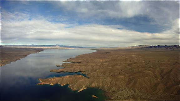
Alamo Lake, at the confluence of the Big Sandy River, Santa Maria River, and Date Creek. The trickle of water released from the dam is the Bill Williams River, which eventually joins the Colorado River north of Parker, AZ.

I climbed not only to cross the lake within gliding distance of shore but to clear the mountains on the far side. As we crossed the lake, I was surprised by the number of campers parked alongside its shore and the boats tied up nearby. I suspected that a fishing tournament might be either starting or finishing up. The lake is popular with fisherman, which is probably a good thing. It’s so remote — heck, it’s a 90-minute drive from Wickenburg — that it simply doesn’t appeal to the typical powerboat/jetski crowd. They usually prefer Lake Pleasant, only 30 minutes from Phoenix (or Wickenburg), which is larger and far more interesting for boating.

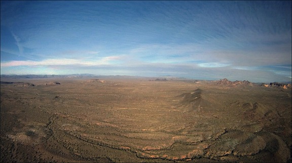
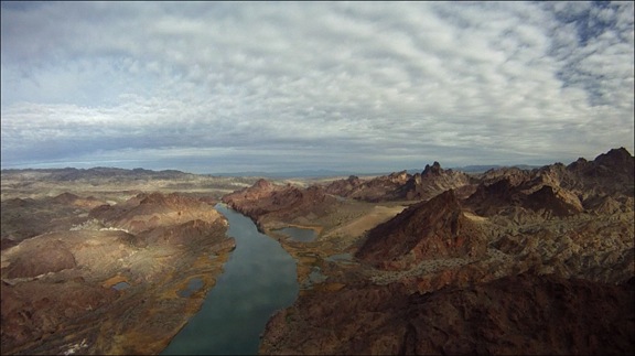
Beyond the lake and the rugged mountains on its opposite shore was yet another stretch of empty desert. But rather than being just a flat expanse, this one was peppered with rock formations left behind by ancient volcanos. There were areas of broken basalt, including flat-topped mesas. In the distance, to our left, we could catch glimpses of the Colorado River. If we’d been in a plane, flying 3,000 feet higher, we’d have a better view of the river and mountains in the distance; at our cruise altitude of 500 to 1000 feet above the desert floor, we could clearly see the details of the rock formations, dry stream beds, and scant vegetation as we flew.

Beyond Alamo
The desert northwest of Alamo Lake is vast and empty.

Forty-five miles from Alamo Lake, we reached Lake Havasu, one of the Colorado River’s many lakes. Formed by Parker Dam far to the south, the lake widens in a broad valley. The founders of Lake Havasu City bought the London Bridge — the real London Bridge from England — and had it installed across a manmade canal as a tourist draw. The town formed nearby. It’s popular for water sports and has a huge influx of visitors during boat races and Spring Break. A friend of mine who lives there complains that the temperatures top 100°F six months out of the year.

Lake Havasu
Lake Havasu’s surface was mirror calm as we flew over, reflecting not only the graceful arches of London Bridge, but the clouds high above.

I’d chosen our route carefully. Two hours is a long time to spend in a helicopter, especially out over the desert where the terrain can be — and, up to that point had been — very monotonous. I planned the trip to follow the Colorado River, which was quite scenic. From that point on, we’d be over one shore or another or at least nearby. It would give my passengers something interesting to see for the second hour of the flight.

Indeed, the scenery along the river can be breathtaking — especially where the river narrows and passes through mountainous terrain. Topock Gorge is one of those places. Although it’s a short stretch of river and takes only five minutes or so to overfly, it’s dramatic and rugged. During the summer season, when the lake busy, speedboats roar through this area all day long. But that day, the lake was calm and quiet and we were treated to beautiful reflections of the sky and canyon walls.

Topock Gorge
Topock Gorge is one of the more scenic areas along the Colorado River between Lake Havasu City and Bullhead City.

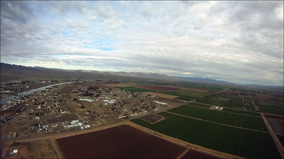
Past the gorge, the river twists and turns in big arcs to the east and west. Rather than follow its course exactly, we headed almost due north. We passed over I-40 where it crosses the Colorado and the farms and communities built up in the Mohave Valley. This was also desert, but desert made habitable by the river that passed through it. Make no mistake: we were still miles from anything remotely resembling a real city — but at least there were people living here.

Mohave Valley
The Mohave Valley, near Needles, CA, is full of farms and small communities clustered up near the Colorado River.

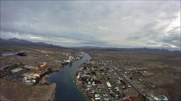
A while later, we were within range of Bullhead City Airport and I called the controller for permission to transition the area along the river. Bullhead City Airport is a real oddity. It was built on the Arizona side of the river to support the casinos in Laughlin, NV. Although it’s well over 100 miles from any international border, it’s an International airport, meaning that you can fly into it from other countries and pass through customs and immigration. It even gets airline traffic; as we flew through the area, a Sun Country 737 was coming in to land. But the airport itself gets very little traffic. This might be because of the natural “wind tunnel” that funnels air up or down the river, resulting in winds that often top 20 knots. But that day, the wind was calm — the first time ever that I’d been there — and other than the jet, we were the only other traffic in the area.

Laughlin, NV
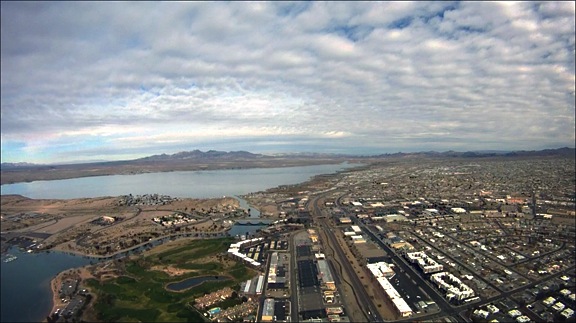
The tall casinos of Laughlin, NV across the river from Bullhead City, AZ. You can see the Bullhead City airport on the far right.

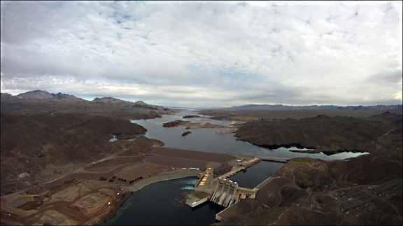
Beyond Laughlin and Bullhead City was the Davis Dam, which forms Lake Mohave. Lake Mohave is another one of the oddities of the desert. Although there are a few marinas and campgrounds along its southern shores, most of the lake is deserted and I seldom see any boat traffic on it. Again, this is likely because of its remote location — although access is easy from the Laughlin area. It seems to me that Lake Mohave would be a great place to become a houseboat hermit.

Davis Dam
The Davis Dam is just upriver from Laughlin and Bullhead City.

Lake Mohave
Lake Mohave seems like the perfect place to get away from it all on a clear, blue lake.

We flew up the eastern shore of the lake and I kept a sharp eye out for wild burros (donkeys). I’d seen them there before. While their trails were easily visible from the air, I didn’t see any animals — or people — at all.

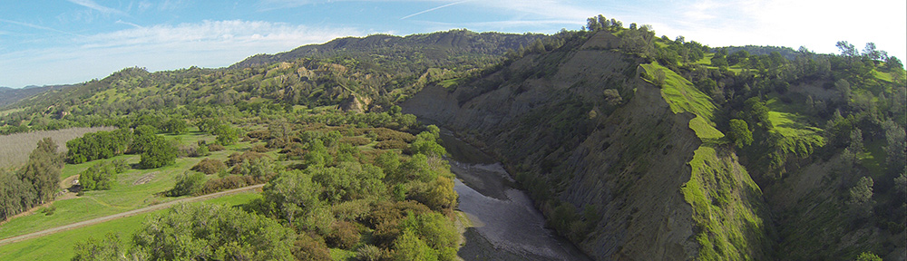
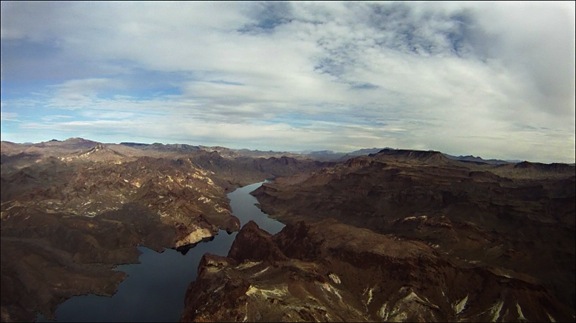
The north end of the lake narrows considerably where the Colorado River winds through a gorge. The rock formations are rugged and starkly beautiful. This isn’t the place you’d want an engine failure — there aren’t many places for an emergency landing. But the landscape draws me to this area each time I fly up the river.

Colorado River
The Colorado River on the north end of Lake Mohave passes through a rugged gorge.

I tuned into the Lake Mead/Hoover Dam tour helicopter frequency and began monitoring communications. I knew that the area around the dam would be full of traffic and wasn’t sure what altitude pilots would be flying at. Routes and procedures are not published; my attempt to get this information from a tour operator failed miserably. (These operators apparently think they own the places they fly over and do what they can to keep everyone else out.)

I reached Willow Beach and made my first call. “Helicopter Six-Three-Zero-Mike-Lima at Willow Beach, heading for the bridge at 2500 feet.”

Some wise-ass tour pilot came on the radio and said “Which bridge? Hoover?”

What an idiotic question. There was only one bridge within 60 air miles. Which bridge did he think? What kind of morons are those tour companies hiring?

“Hoover,” I replied.

“Be advised that there will be four Maverick helicopters over the dam in about two minutes,” he replied. No indication of altitude or any other useful information.

Other pilots were more generous. Although the Papillon Pilots seemed to be crossing the river farther south at 3500 feet, the Maverick pilots were operating near the dam at 3000 feet. I planned to say at 2500 feet, which would keep me out of their way.

The bridge came into view around the same time the Maverick helicopters started appearing overhead. They were flying an odd S-shaped pattern that was obviously designed to give all their passengers a view. I did a three-quarter circle from the right to the left as my passengers leaned forward and then left to see. They got a good look — I was not prepared to loiter and they didn’t seem as if they needed me to. Then I was exiting the area along the road to Boulder City.

Hoover Dam and Bridge
The Hoover Dam and its new bridge are a popular tourist attraction for Las Vegas visitors. They’re amazing from the air.

I wasn’t finished yet, though. Another tour operator does very short tours of the dam and bridge from the Hacienda Hotel just up the road. He was preparing to launch as I flew over. He kindly said he’d wait until I’d passed by, then thanked me for talking on the radio. (Apparently, some pilots don’t — that’s a scary thought.) I thanked him for listening.

Not knowing the approach procedures for Boulder City Airport and anxious to stay out of the way of any other tour traffic, I stayed low as I crossed over the city and headed for the airport. (I was later told I’d likely get in trouble for that, but no one ever called. I guess I lucked out.) There were skydivers falling from the sky near the airport so, to stay clear, I circled around to the east and landed along one of the runways. I was still on edge from mixing with so much other traffic when I set down on one of the helicopter parking spots for the FBO.

Boulder City
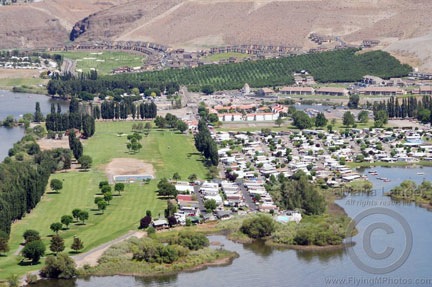
Boulder City was built 90 years ago to provide a home for dam construction crews. It’s since grown to a vibrant community — the only one in Nevada that does not allow gambling.

We’d been in the air for 2.2 hours and I was ready for a break.

More about this trip in another post…

How to Set Up and Share a SPOT Messenger Page

It’s included in the Track Progress service, so why not?

SPOT Personal TrackerI’ve been using a SPOT Personal Tracker for the past two years. It was recommended to me by a helicopter pilot friend. We both fly in remote areas — the kinds of places that if you go down, rescuers are probably not going to find you before it’s too late.

Think I’m kidding? Check out this Cessna, which was not located for 31 months. I was just one of dozens of local area pilots who looked for this plane whenever I was in the area where it disappeared.

And what pilot can forget the disappearance of Steve Fawcett? Millions of dollars and lots of high-tech search techniques were used to try to find his plane. Over a year passed before a hiker found Fawcett’s ID and the wreckage was eventually found.

I didn’t want to end up like either one of these unfortunate flights. Even if I suffered a fatal crash, I wanted to be found as soon as possible. And if I simply went down and needed help, I wanted help to be able to find me without relying on cell phone signals.

The SPOT Service

So I bought a SPOT Personal Tracker and subscribed to two services:

  • Basic Service enables the SOS (AKA 911), Help, and Check-in/OK features of the unit. That requires a button push to send the message. This service costs $100/year and is required to use the device.
  • Track Progress drops “breadcrumbs” of your location every 10 minutes so others can track you. The track progress feature automatically plots your location signals on a map that’s accessible online. You can create a shared page, give the URL to whoever you want, and let them track you. The benefit of this — as far as I’m concerned as a pilot — is that if I go down suddenly and am incapacitated, people tracking me will not only know where I was within the previous 10 minutes of my mishap, but they’ll likely know which way I was going. Plus, if the unit is intact, it will continue to broadcast my location every 10 minutes. This non-moving signal should help them pinpoint my location — even if I’m dead. This extra service costs $50/year. While I have another pilot friend with a SPOT who doesn’t use it, I think every pilot who uses this device should cough up the extra dough for this service. You can’t always press a button when you need help.

I need to stress here that this is not a device designed for aviation. It’s really designed for “adventure activities” or travel — for hikers and campers and mountain climbers and kayakers. For folks who get out in the wilderness. Of course, pilots who fly in remote areas can benefit from the device and there are plenty of stories of how it may have saved aviator lives. Just keep in mind that it is not an approved FAA tracking device and that flight plans should always be filed and opened for remote area flights. And, if you’re an airplane pilot who flies at altitudes where FSS Flight Following is possible, why not use that service? Unfortunately, Flight Following is not usually available at the altitudes at which I fly my helicopter.

Creating a Shared Page

Of course, having a SPOT Personal Tracker with the Track Progress feature means a Share Page (example shown below) is included with your subscription fee. It makes sense to set up this page and share it’s URL with the folks who need to know where you are. You can also share it with the world at large if you’re like me and don’t care who knows where you are when you’re on the go.

Shared Page
Some recent activity; I did 20-minute helicopter rides the other day.

Setting up a SPOT shared page is easy. Assuming you’ve already set up your account on the SPOT Web site and have activated your device, just follow these steps:

  1. Sign into you account at FindMeSpot.com.
  2. Share Tab
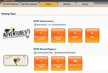
Click the Share tab near the top of the page.
  3. Under SPOT Shared Pages, click the Create Shared Page link.
  4. Create Page Settings
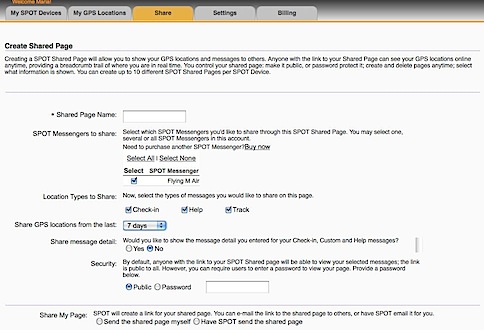
Set the options in the Create Shared Page window that appears. Be sure to enter a Shared Page Name and select your SPOT device. Under Security, you can specify whether the page is Public or requires a Password to access. Personally, I recommend keeping it Public. You can always limit who you give the URL to. It would be terrible if someone needed to access the information and couldn’t remember the password.
  5. Select one of the options at the bottom of the page to determine how you’ll notify the people you want to share the page with about the page’s URL:
    • If you select Send the shared page myself option (recommended), a message appears, telling you that anyone with the link can view your shared page. Click Create Now to complete the process.
    • If you select Have SPOT send the shared page, a form appears for you to enter up to 50 e-mail addresses and create a custom e-mail message. Be sure to keep the Send a copy to you check box turned on so you get the URL, too. Click Send Now to complete the process.
  6. URL CreatedAt the bottom of the page, a very long URL should appear. Triple-click it to select it and chose Edit > Copy (or press Command-C (Mac) or Control-C (Win)) to copy it to the clipboard. We’ll use it in a moment to test the link and create a short URL.

Shared PagesIf, for some reason, you didn’t get the URL or you need to access it again in the future, click the Shared tab (shown above) and then click the Manage Shared Pages link under SPOT Shared pages. You can click the name of the shared page to display it. You can then copy the link for that page from the Web browser’s address bar.

Creating a Short URL

http://share.findmespot.com/shared/faces/viewspots.jsp?glId=0aISLWHRq9KlETLqzcfFGQuD8VboS6R8O is not exactly the kind of URL that’s easy to share with friends. Fortunately, URL shortening services enable you to create a custom URL for any page. Although this step isn’t required, it’s certainly recommended.

Although I originally created my short URL with the TinyURL service, you can use any service you like. Bit.ly makes even shorter URLs, but it requires an account to create a customized one. So in this example, I’ll use TinyURL again.

  1. Point your browser to TinyURL.com.
  2. TinyURLPaste the URL for your shared page in the top text box.
  3. Enter a short word or phrase that’s easy to remember in the bottom text box. In this example, I’ve entered the N-number for my helicopter. My original URL used FindMaria.
  4. New TinyURLClick Make TinyURL!
    A message like the one shown here appears, confirming that the new URL was created. You can now give this much shorter URL to family and friends.

Share Your SPOT Page!

Are you already using a SPOT device? If you’ve got a page set up, share it here. Use the Comments link or form for this post. No need to enter any HTML tags; just enter the complete URL. Once your comment has been approved, your shared page will appear. I’d also love to hear comments about the device — good or bad.

Greetings from Washington’s Cherry Country

Cherry drying season is off to a busy start.

Cherries

Cherries, at the source.

I’m in central Washington state for my third season as a cherry drying pilot. The short explanation of that is that cherry growers often rely on helicopter pilots to hover over cherry trees after a rain to shake/blow water off so the cherries don’t split or rot.

I’m based in Quincy, WA, living in my RV with my helicopter parked across the street at an ag strip. I arrived two weeks earlier than I had to. I didn’t know I was that early — I try to arrive about 5 days early. But my first contract was supposed to start early. It was only after I arrived that the start date was finalized to a much later date. It was supposed to start today.

Rain, Rain, Rain

Meanwhile, it’s been raining like crazy here. In the two weeks I’ve been in Washington, I’ve seen more rain that the past two seasons combined. My buddy, Jim, started a contract down in the Mattawa area about 10 days ago and has already flown more than 10 hours.

How important are helicopter pilots to the success of the crop? Well, this story should give you an idea:

Jim originally had two orchards under contract and was drying both when called to do so. One day, there was a light rain and only one grower called. He dried that orchard, then called the other grower to see if he needed his dried, too. He told Jim that the cherries didn’t seem that wet, that he thought he could dry them himself with the blower equipment he had on hand. Three days later, he cancelled the contract because he’d lost 60% of his crop to water damage after that light rain. He wasn’t even going to bother picking the rest.

The loss of so many cherries in this season’s crop makes the remaining cherries even more valuable. Last season, the problem was that there were too many cherries and the growers weren’t getting a good price. Some of them would have had a loss on their crop, so they didn’t even bother to pick.

But this year, with all the rain we’ve been having, cherries are going to be difficult to protect. Any grower who doesn’t have cherry drying hover service lined up for his orchards will likely lose his crop.

Expect to pay more for cherries this year, folks.

My First Dry

As for me, that first contract started a day early. It rained overnight from Thursday to Friday and was still raining when I got up in the morning. At about 9 AM, my grower called and said he’d likely have me start a day earlier. He launched me at 10 AM, right after the rain had stopped.

The clouds were still low when I made the 6-mile trip to his 32-acre orchard block on the Columbia River. I ducked beneath them and made the steep descent to the river. Remembering the pattern I’d flown the year before, I circled the orchard, descending. I settled into a hover five feet over the tops of the trees in the southeast corner of the block, being careful to avoid the water tower beside the trees there. And then I got to work.

Crescent Bar Orchard

My client’s orchard is the big patch of dark trees in this photo.

This particular orchard is one of the most difficult I’ll have to dry this year. There are trees at various ages and sizes. Some rows go east/west while others go north/south. There’s a gully deep in the west side with trees going right down into it and a house tucked into the south side. And a processing shed in the middle.

The grower arrived about 10 minutes after I’d started. I think he took some video of me flying around. And there were onlookers along the road from the nearby trailer park and condos.

It took me 1.2 hours to get there, hover over all the trees, and get back. The grower waved and stepped into his truck as I left the last tree and started my climb out.

More to Come

There’s a 20% chance of rain tonight and a 30% chance of rain tomorrow morning. So I’d say I have a 30% chance of flying again tomorrow.

While I hate to see the growers spending a lot of money to protect their crop, I have to admit that it’ll be a nice change for me to have a profitable year.

Who’s Filtering Your E-Mail?

And why?

The other day I sent an e-mail message to one of my editors. Within seconds, the message was bounced back to me with this notice at the top:

Hi. This is the qmail-send program at smtpauth22.prod.mesa1.secureserver.net.
I’m afraid I wasn’t able to deliver your message to the following addresses.
This is a permanent error; I’ve given up. Sorry it didn’t work out.

<[redacted e-mail address]>:
[redacted IP address] does not like recipient.
Remote host said: 554 5.7.1 Service unavailable; Client host [64.202.165.44] blocked using dnsbl.ahbl.org; GoDaddy – Continued hosting of FreeSpeechStore hate website on 72.167.250.55, ignoring abuse
Giving up on [redacted IP address].

My first thought was WTF?

I tried again and got the same result. Then I started researching. I discovered that www.ahbl.org is the domain name for the Abusive Hosts Blocking List (AHBL), an organization that apparently maintains a list of IP address it deems as abusive. The owner or manager of the site had decided that he/she didn’t like GoDaddy.com because it hosts the conservative “hate speech” site FreeSpeechStore. (And no, I won’t link to that drivel.) My editor’s ISP was evidently using AHBL to filter incoming mail.

I e-mailed AHBL the following message using my MobileMe e-mail address (since I assumed my e-mail account hosted at GoDaddy.com would be blocked):

Unfortunately, I host a non-abusive site and my main e-mail (not this one) is at GoDaddy.com. Your site is preventing my e-mail from reaching some destinations because of some link between GoDaddy.com and freespeechstore.com.

Do you really think this is fair to me and others in the same situation?

The response I got was surprising. Someone named Brielle Bruns wrote:

Unfortunately, your provider has stated to us that they will not enforce their Terms Of Service or Acceptable Use Policy. They are turning a blind eye to abuse and harassment, which is something we can no longer ignore.

To give you an idea of why we are taking this issue as seriously as we are, one of Mr Scoville contacted the local police department, fire department, child welfare, schools, etc of one of his victims, and claimed that he and his wife were molesting their children and others from the school.

Put yourself in the victim’s shoes, and then ask yourself weather or not you’d do whatever it took to prevent anyone else from being victimized by Mr Scoville.

I repeat: WTF? My response explained exactly how I felt about the situation:

I really don’t see why I need to be dragged into this.

I agree wholeheartedly that if what you say is true, this Scoville character is an asshole and a menace to society. But let’s look at this objectively on two fronts:

– One of the founding principles of this country is free speech. If Scoville wants to create a website full of hate speech, it is his right to do so. You’re attempting to censor him by acting as a third party filtering service. Seriously: what gives you the right?

– To punish him and (assumedly) GoDaddy.com, you’re punishing ME, an innocent bystander to this whole thing. Your failure to allow my message to be received by my editor directly interferes with my ability to submit work and invoices for that work. You are cutting into my ability to make a living. WTF?

I don’t care WHY you are taking this seriously. It’s none of your business — or mine. Let the police handle it — that’s what our tax dollars pay them to do.

I’ve issued a complaint to my editor and asked him to contact his ISP or system administrator — whoever is using your services. I’ll forward this message to him as well. You are stepping beyond your legal rights in this. I’m hoping my editor complains and your service is no longer utilized by his company or ISP.

The response I got back picked apart my e-mail message paragraph by paragraph, attempting to justify the site’s action against GoDaddy just because it hosts some wacko’s Web site. Honestly I didn’t even bother reading it. It was clear that Bruns was just as wacko as the person he/she was trying to harm — by harming people like me. Clearly, I was wasting my time communicating with this person.

So I wrote to the editor I’d been trying to contact, this time using my MobileMe account. I’d already updated him about what was going on. Now I decided to make a formal request:

I respectfully request that you ask your ISP or system administrator to stop using the services of Abusive Hosts Blocking Service. They are preventing me from communicating with you on my primary e-mail address, dragging us into some sort of war they have with GoDaddy.com, and simply do not care how much they inconvenience innocent bystanders.

The fact that your ISP or System Administrator utilizes a service that would do such a thing is unthinkable to me.

When I didn’t get a response, I followed it up with this:

Seriously…you need to do something about this. Whoever authorized use of this blocking organization is preventing me — and possibly your advertisers! — from contacting you. THIS IS DEFINITELY A PROBLEM ON YOUR END. Tell your ISP or System Administrator to shut that service off.

The woman who runs it is on some kind of holy crusade and she’s been very rude to me in our e-mail exchanges. I’ve lost an hour of my day troubleshooting this issue, only to be frustrated by her holier-than-thou attitude.

The day ended. The editor is back east, so I didn’t really expect immediate action. In the morning, however, I had the result I wanted. My editor wrote:

Thanks for letting me know what you’ve learned. I’ll be discussing it with my boss today and we’ll figure out what the next step will be.

I later was CCed on an e-mail message from my editor’s boss to the company’s ISP:

Below is a dialogue between one of our writers and someone named Brielle Bruns from an outfit called “The Summit Open Source Development Group” which seems to be at the root of our problem receiving some business critical e-mails from Godaddy based addresses.

In addition to blocking e-mails from our writer, I have had one of my attorneys e-mails blocked and missed an important deadline as a result. I have no idea how many e-mails have been blocked from our subscribers or [redacted] customers but I have to believe the number is sizable.

As far as any of my businesses are concerned, please IMMEDIATELY STOP using what ever “service” is being provided Brille Burns’ outfit. What ever dispute she or her group has with this Scottville guy, it nothing to do with us and her organization is negatively impacting our business and customers.

Please take care of this immediately.

I replied with a thank you message to my editor and his boss. The block was soon lifted and I could again begin using my regular e-mail address to communicate with my editor.

One of the subsequent messages flying back and forth between the parties included this comment:

PS: We just found this: from 2.5 years ago ref: “Brian J. Bruns convicted felon and owner of www.ahbl.org Abusive Hosts Blocking List AHBL” http://criminal-brian-j-bruns.blogspot.com/

The link is to a Blogger blog that purports to share documents about this person’s felony conviction and sexual deviations. (I still can’t believe the kind crap out there on the Web.) It looks pretty real, but I’m a skeptic on these things and wouldn’t be the least bit surprised to learn that it was Brin’s nemesis, Scoville, slinging dirt. Seriously: some people need to get a life.

When the hubbub had died down, I e-mailed the ISP representative. I had his e-mail address from the message initially to him that I was CCed on. I told him I was interested in blogging about this and asked a few questions. He replied that he’d have to ask his boss about some of the answers, but he did state the following:

I can tell you, though, in regards #3, we were using the service entirely for spam prevention. We use a number of different services for spam prevention, and had no knowledge of their political agenda. As soon as we found out what was going on with this service, which was, coincidentally, shortly before [redacted] e-mailed us, we stopped using this service. I am very sorry for the problems this caused, and we would never knowingly use a service that had a political agenda like this.

Which begs the questions:

  • What “service” is your ISP using to combat spam?
  • How many important, legitimate e-mail messages have you missed because of a situation like this?
  • What gives organizations the right to classify an IP address as abusive or harmful, regardless of who else might be using it via shared hosting or e-mail?

If you or your ISP is using AHBL, stop now. The company obviously has a political agenda that does not consider the negative aspects of its actions. Why would anyone use a company like this to filter e-mail? Wouldn’t you rather get a little spam than miss out on important communications from friends, family, and business associates? I would!

As for me, I’d already begun moving my Web sites and e-mail addresses away from GoDaddy.com — but for other, service-related reasons. They still have not provided a satisfactory explanation to me about what’s going on with the “hate site.” This just confirms that my switch to a new ISP was long overdue.