Creating Defensible Space

Fire season is serious business in the west.

Every fire season seems to get a little worse in the west — particularly in the Pacific Northwest where I now live. For the past four summers, we’ve had widespread wildfires, most of which were started by lightning strikes. Fires have been particularly threatening, if not downright damaging, near my new home:

  • In September 2012, lightning strikes started over 100 wildfires from Blewett Pass to Lake Chelan. Visibility dropped down to less than 1/2 mile in smoke and mandatory evacuations affected the Wenatchee Heights area that was my temporary home not long after I left for Arizona.
  • August Fire
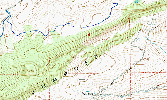
    I was at a party at the airport on the evening of August 10 while Jumpoff Ridge was burning.

    In August 2013, lightning strikes started a handful of fires on Jumpoff Ridge, the cliffs that tower behind my current home. Although I’d just purchased the land and didn’t have anything on it, I was as alarmed as my neighbors when my road was put on mandatory evacuation, mostly because firefighters feared that burning debris would tumble down the cliffs and start new fires on our level. (Fortunately, that didn’t happen.)

  • In July 2014, more than 300 homes were destroyed when a fire hit the community of Pateros, about 45 miles upriver from Wenatchee. Other fires up the Methow River near there destroyed forests, orchards, and a few more homes.
  • Sleepy Hollow Fire at Night
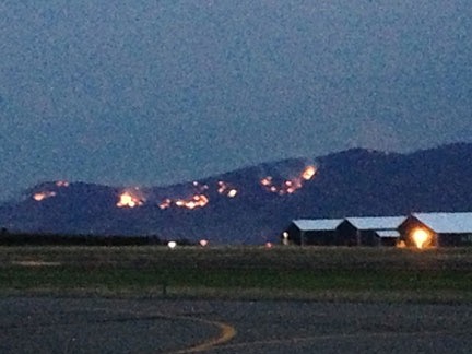
    I shot this photo of the Sleepy Hollow Fire on the night of June 28, 2015 from my deck using a 300 mm lens. It isn’t cropped. Although the fire was more than 8 miles from my home, I found it terrifying and could not sleep that night. A pair of heavy rainstorms the next day put the fire out — and started the Wolverine Fire up near Lake Chelan that’s still burning today.

    In June 2015, the Sleepy Hollow fire destroyed more than 20 homes in a Wenatchee subdivision overlooking the town. Burning embers from the fire traveled on the wind and touched off fires a half mile away, destroying 3 warehouses and fruit packing and storage facilities.

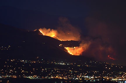
As I write this, there are dozens of fires all over Washington, Idaho, and Oregon. These fires are growing at alarming rates. The Okanogan Complex Fire, for example, started on Saturday, August 15 — that’s just 8 days ago — and has already grown to 227,206 acres. That’s 355 square miles — larger than the entire city of New York (all five boroughs).

Can you imagine all of New York City burning in a week?

And that’s just one of the monster fires. Chelan Complex has burned 87,412 acres in the Chelan area, North Star has burned 132,000 acres on the Colville Indian Reservation, and Grizzly Bear Complex has burned 59,150 acres in the Umatilla National Forest. The Interagency Inciweb website is currently tracking 26 fires in Washington State alone. The President has declared Washington a disaster area. This is some serious shit.

Although the closest fire is at least 20 miles from here, a wind shift has brought smoke into the valley. Visibility is less than 3 miles — I can’t even see the airport from my home. The smell of smoke is in the air. I spent much of yesterday outdoors doing light work and wound up with a sore throat from breathing smoke.

Visibility.jpg
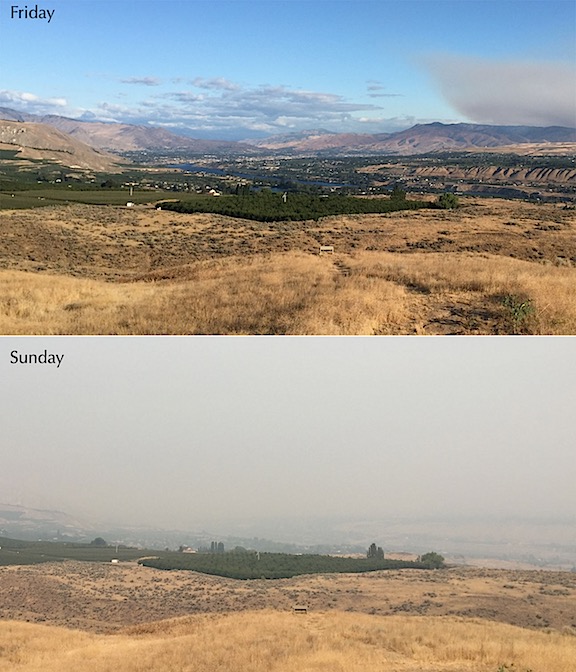
On Friday, the air was very clear, although I could see the smoke cloud coming our way. This morning, the air is thick with smoke. I can barely see the buildings at the airport just 3 miles away.

The scariest part of fire season for those of us who live on the outskirts of town, surrounded by natural vegetation, is the fact that it doesn’t take much to start one of these crazy fires. Lightning is the most common cause, but fires have also been started by cigarette ash, sparks from chainsaws or mowers or ATVs, and even cars with hot engines parking on tall, dry grass. If Mother Nature doesn’t start a fire, some careless idiot might.

As you might imagine, the idea of “defensible space” is on many people’s minds. In theory, it means keeping enough clear area around your home so that firefighters can defend it from wildfire. That usually means cutting down trees and bushes and trimming long grass, surrounding your home with heavily irrigated vegetation such as green lawns or orchard trees, and removing any firewood or scrap wood piles near your home. If your home does not have defensible space, not only is it more likely to burn in a wildfire, but firefighters may not even try to defend it because of the danger it could put them in.

I did much of this over a month ago when I used my string mower to cut back the tall, dry grass on the side and back of my home. I debated cutting a few of the small sagebrush in the area — they burn hot and fast when ignited — but left them. The other two sides of my house have concrete and gravel and a small lawn.

Of course, some of us take it the next step by installing sprinkler systems that can be turned on, when needed, to soak the area. I did that the other day. I drove two 6-foot T-posts into the ground, one at each corner on the road side of my home. Then I fixed 50-foot sprinkler heads to the top of each one. I ran hose from my shed — which has extremely high water pressure — to the first sprinkler and another hose from that one to the second one. When I turned them on, they provided coverage along the entire road-side of the building, as well as about 50 feet down the front and back.

Sprinklers
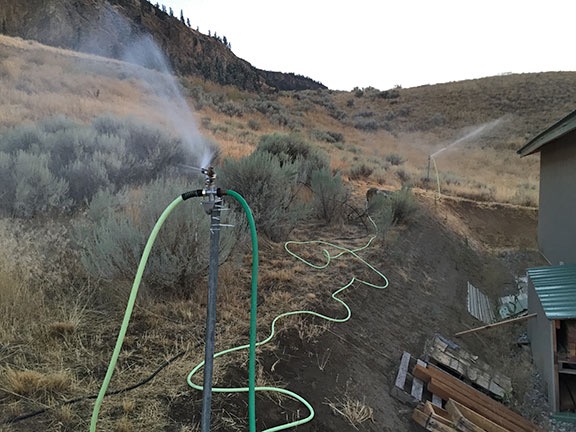
Here’s my sprinkler setup on the road side of my home. I do need to move some of the scrap wood there, or cover it with some of the metal panels I have.

I want to add a third sprinkler to the roof of my shed, which would protect the shed and chicken coop. A fourth sprinkler head can be mounted on my deck in the other back corner of the building to provide some protection there.

My friends have been asking me whether I have a generator for the water pump. They assume I have a well. I don’t. I have city water which should keep flowing as long as the water company keeps it coming. I guess I should hope that they have generators.

Yes, I know it isn’t perfect, but it’s better than nothing.

The good thing is, my building is made of metal. So flying embers landing on the roof or against a wall should not be able to start a fire. There are some exposed wood beams, however, and I’m not fooling myself into thinking the building is fireproof. As too many folks around here have learned over the past few years, even metal buildings can burn if they’re subjected to enough heat. My goal is to prevent that heat from getting close enough.

I’m not the only one thinking about fire. Kirk has moved his vehicles into his orchard, which is far less likely to catch fire if fires come through the canyon where he lives.

Anyone who lives in an area prone to wildfire damage who doesn’t create defensible space around their home is an idiot, plain and simple. As we’ve seen this year, even homes in subdivisions that are normally safe from wildfire danger can be completely and utterly destroyed. Why would anyone fail to take steps to protect their home before such protection was absolutely necessary?

When the fires come, you often don’t have time to act before evacuation. I feel a bit of comfort knowing that I can get my sprinklers going in a matter of minutes now because they’re already in place. This might mean the difference between keeping my home standing and losing everything I own.

Jumpoff Ridge and Clear Lake

A Jeep drive to an exploratory hike.

Kirk and I spent much of Wednesday morning clearing boxes of items out of my RV (AKA the “Mobile Mansion”) as part of a major cleanup. It was a big job made more manageable by a helper who kept me focused and moving. I suspect that if Kirk and I joined forces for any big job, we’d get it done in record time.

Afterwards, we went inside for a break and lunch. I whipped up some pizza dough and picked eggplant, zucchini, and tomatoes from my garden. By 1 PM, we were each making our own pizza masterpieces, which we later ate out in the shade on the deck.

That took us to 2 PM. Half the day was still ahead of us.

We’d talked about taking out the boat for a short ride, but it was windy down on the Columbia so we put it off for another day. Then Kirk suggested taking the Jeep up onto Jumpoff Ridge, where a road wound along the edge of the cliff. I’m always game for a Jeep ride, so we pulled out the Jeep, loaded Penny and some bottled water on board, and took off.

On Jumpoff Ridge

Jumpoff Ridge is the name of the cliff face due south of my home. It rises more than 1,000 feet from the shelf where my home sits. The side facing me is layered basalt columns that are strikingly beautiful, especially with golden first or last light shining on them. Topo maps and satellite images show a road up there that meanders along the top of the cliff. One of the local property owners, in an attempt to avoid contributing to road association fees, claimed he’d use that road to access his land — yes, his 20 acres does include the cliff face and a sliver of land on top. I’d been wanting to check out the road for at least a year and was looking forward to the drive up there.

Jumpoff Ridge Topo
A topo map shows the steep cliff on the north side of Jumpoff Ridge. The road we planned to drive is indicated by the double dashed line atop the cliff. The blue track line to the right of the sharp turn is the road I live on, which was built after USGS topo maps were published.

I knew how to get to the road we sought. Follow Joe Miller Road to Stemilt Loop Road and turn left at the church. Then follow that to Jumpoff Ridge Road. From there, it turns to improved gravel. It’s a moderately steep climb through ponderosa pine with tantalizing glimpses of the orchard-filled land in the Stemilt Hill and Wenatchee Heights areas below. There are about a dozen lots, some of them with homes on them, at the top of the road. One of them belongs to one of my charter clients and I’ve landed and departed with the helicopter from his yard at least a dozen times over the past two or three years.

Top of Jumpoff
At the top of Jumpoff Ridge, the topo map showed a 4-way intersection. But there was no left turn to the radio facility.

That’s also where the road splits. A left hand turn at my client’s house would take us to the road we sought, but the only left hand turn we saw looked like my client’s driveway. We could see the antennas — marked “Radio Facility” on the topo map — beyond and knew that’s where we needed to be. But there didn’t seem to be a way to drive through. So we went straight, looking for another left hand turn.

We found it a while later, but it was gated and locked. We kept going, passing under the Bonneville power lines and a handful of other homes. (When people say I live “out there,” they should come visit these people. They’re way out there.) Realizing the road was not likely to take us where we wanted to go, we turned back and had a closer look at that gate. It was securely locked with signs warning against trespassing. The road was strictly for communications company and power company use.

I guess my freeloading neighbor had no idea what he was talking about when he claimed he’d use that road to access his property. (Or, more likely, he was just a lying sack of sh*t.)

We stopped to consult the map I’d preloaded onto my phone’s Gaia GPS app. I’d already told Kirk about Clear Lake, where I’d stopped in November with my friend Don. It had been frozen hard that pre-winter day, after an early hard freeze. Don had bowled rocks across its surface just to hear the weird echoing sound as they bounced and slid. I thought it was a good alternative destination. The map showed a road off the southwest-bound powerline road (which was not gated) that would “shortcut” to it. It even had a name: Rock Ridge Road. We headed off to find it.

The road climbed steeply up a rocky slope and joined up with the Bonneville Power lines. It veered off into the forest and rejoined the powerlines. Then there was our right hand turn, right where the map said it would be. But there was also an “Authorized Vehicles Only” sign. Really? Ugh.

Faced with the choice of going back or taking the longer way around, we kept moving forward. The road was a lot longer than I remembered. It joined and left the powerlines several times, mostly climbing. There were tall pines, surprisingly green grass, and large meadows. I could easily imagine elk grazing there.

My 1999 Jeep Wrangler drove like a champ. I’ve owned this vehicle since new and, quite frankly, I don’t take very good care of it. In fact, I think it’s safe to say that I routinely beat the crap out of it. It had been flashing the Check Engine light on rough terrain on and off, coupled with a stuttering engine, for months.. Earlier in July I’d finally had it checked and fixed. Turned out to be a wiring harness damaged by rodents — a much cheaper fix than I’d been prepared for. This was a good practice run for our upcoming camping trip to Glacier National Park and I was glad to see it running so smoothly.

After miles of rough road, we finally found and made the right hand turn that would take us down off the ridge: Schaller Road, according to the map. It was rocky, rough, and full of switchbacks. That dumped us onto Upper Basin Loop Road. We caught a glimpse of a pickup truck turning onto a road up ahead — the first vehicle we’d seen in over an hour — and kept on straight until we reached the turn for Clear Lake.

At Clear Lake

Clear Lake
Clear Lake is a small reservoir in the woods.

Clear Lake is a very small reservoir in the Stemilt Basin. It likely collects and stores water for one of the dozens of Stemilt cherry, apple, or pear orchards in the Stemilt Hill area. The road ends at a locked gate close to the lake. We parked and got out for a walk. Penny was very happy to get out of the Jeep, where she’d been riding on Kirk’s lap since our departure from home. There was no one around and it was peaceful.

The topo map showed another larger lake to the west, on the other side of the ridge: Lily Lake. Although our time was somewhat limited — Kirk had a meeting later that evening in Cashmere and the drive had already taken longer than planned — we set off to see if we could catch a glimpse of the other lake. Like me, Kirk has kayaks and we’re always interested in finding new destinations for a leisurely paddle.

Lean To in the Woods
We stumbled upon this old lean-to in the woods up the hill from Clear Lake.

We followed a trail and then a road and then a trail o the west side of the lake and started the climb up the ridge. Near the top, we found an old lean-to made with branches and the remains of a campsite. But not much else.

Thimbleberries
Ripening thimbleberries. While not as tasty as raspberries or blackberries, they do make a nice treat.

We dropped down and followed the road back to the southeast. There was another locked gate and we walked around it. That took us southwest on a road that small trees were already starting to reclaim. Thimbleberry bushes lined the road and Kirk and I picked and ate the reddest ones. A small creek roared in a steep but narrow canyon beside us. After about a quarter mile, the road dead-ended at a dam with a valve: the control for the underground pipeline that was filling Clear Lake from the creek. There was no road or trail beyond to Lily Lake.

Dam
A concrete dam in the forest formed a small pond where a buried pipeline fed Clear Lake. Water over the spillway fed the creek we heard in the ravine beside the road.

After snapping a few photographs, we headed back to where the Jeep waited. We’d visit Lily Lake another day from a road on the other side of the ridge that I’d already spotted on the map. There were other lakes up that way and it would make a good day trip for us, giving me the Jeep outing I wanted with the hiking Kirk preferred. Win-win.

Heading Home

The trip home was uneventful. It was less than a mile back to pavement from Clear Lake. Then back to the church and Joe Miller Road and, eventually, my road.

Kirk snacked on some cold pizza as we loaded up his car. He headed out for his meeting. I heated the rest of the pizza in the oven and snacked on it while unwinding from the bumpy trip, glad to have found an excellent traveling companion for future adventures.

Curious about our route? Click here to see it and all the photos I took.

Spring Day from My Deck Time-Lapse

A windy spring day.

I set up my GoPro on a tripod on the deck outside my bedroom door for a time-lapse on Monday before dawn. Unfortunately, Monday was a rather ugly day — cloudy and kind of dreary. The resulting time-lapse would not have been share-worthy.

So I left the GoPro running and captured enough images for a 4 AM to 10 PM time-lapse on a much prettier — but windier — day. Can you see the point where the wind blew over my tripod? (I deleted the shot of my deck roof.)

Should have set this to music but I didn’t. Sorry!

I’ll try this again in a few weeks with the image zoomed in a bit. I thought I’d set it right for this one, but apparently I didn’t.

About the Wind Machines

An important part of crop protection.

The economy of this area of Washington State is based primarily on tree fruit production: apples, cherries, pears, and apricots. Indeed, Columbia River Valley around Wenatchee is one of the biggest apple producing regions in the world.

Fruit trees bloom in the spring, are pollinated by migratory bees, and form fruit. Throughout the summer, the fruit develops and grows. Months later, when the fruit ripens, it’s picked, sent to processing plants, and either shipped out immediately, as in the case of cherries, or stored for later shipment, as in the case of apples.

The timing of all this is determined by the weather and can fluctuate by several weeks every year. The trees get a cue from temperature to start budding and once the buds are formed, there isn’t much that can stop the seasonal progression.

Except frost.

Frost can kill flowers and developing fruit. A bad enough deep freeze over the winter months can even kill trees.

And that’s where frost protection comes in. Growers are deeply concerned about frost destroying a crop so they take steps to protect the crop from frost. In this area, they rely on wind machines to circulate the air in parts of an orchard prone to pockets of cold air.


This video shows wind machines in action at a pear orchard in Cashmere, which is near here. It looks to me as if the trees are in bloom. Unfortunately, the sound is turned off so you can’t get the full effect.

Wind machines look like large, two-bladed fans on a tall pole. Usually powered by propane, they’re often thermostatically controlled — in other words, they are set to turn on in the spring when the temperature drops down to a certain point. The blades spin like any other fan and the fan head rotates, sending wind 360° around the machine’s base.

The idea, of course, is that the cold air has settled down into pockets and that warmer air can be found around it and above it. By circulating the air, the warm air is brought around the trees and frost is prevented.

In California, they use helicopters to protect the almond crop from frost. (As a matter of fact, as I type this my helicopter is in California for a frost contract for the third year in a row.) The principle is the same, but the orchards tend to be much larger and I can only assume that it isn’t financially feasible to install and run wind machines in that area. (Hard to believe it’s cheaper to use helicopters, though.)

This year, some unseasonably warm weather has triggered a very early bloom. My clients tell me that their cherry crop is running 2 to 3 weeks early. Right now, cherries are in various stages of bloom throughout the area; apricots are pretty much done with their bloom. (Apples and pears will come next.) And since winter has not let go of its tenuous grip on us, the temperature has been dropping down into the low to mid 30s each night this week.

Well, not at night. It actually starts getting cold around 4 or 5 AM, as you can see in this weather graph:

Weather Graph
The National Weather Service weather graph page for this area shows the forecasted highs and lows over time.

The result: the wind machines kick on automatically when it starts getting cold: around 4 or 5 AM.

Want to hear what a wind machine sounds like close up? This video has full sound as a field man starts and runs up a wind machine. He’s wearing ear protection for a reason. Stick with it to see the spinning head on top.

Wind machines are not quiet. In fact, from a distance, they sound exactly like helicopters. And as they spin, they sound like moving helicopters — so much so that when I first heard them in action back in Quincy in 2009 or 2010, I thought they were helicopters and actually got up to see what was going on. I suspect that to someone on the ground, they sound exactly like a helicopter drying cherries would sound.

Although there aren’t any orchards on my end of the road, my property does look out at quite a few orchards, some of which have wind machines. There are at least 5 within a mile of me — I can see 4 of them from my side deck. I can also see others much farther out into the distance. And when the close ones are running, I know it. It’s not loud enough to wake me up in my snugly insulated home, but it sure did wake me up when I was living in my thin-walled RV outside. And it’s definitely not something you can pretend you don’t hear.

Fortunately, wind machines are a seasonal nuisance — much like other orchards noises: sprayers, tractors, helicopters, and pickers. Although frost season runs through May in this area, the machines only kick on during cold weather. Looking at the forecast, I can expect to hear them tomorrow morning and probably Wednesday morning, but not likely on Monday or Tuesday morning.

Weather ForecastNWS Wenatchee forecast for this week.

In the meantime, I’ve already gotten the heads up from my California client who might need me down there on Monday. After all, they don’t have wind machines.

For a helicopter pilot working in this area, wind machines are one of the obstacles that can be a hazard when drying cherries. They tower higher than the trees and their blades can be “parked” at any angle or direction. Although some growers will try to use wind machines to dry trees while waiting for pilots, my contract states I won’t fly in an orchard with wind machines spinning so they’re usually turned off when I arrive — or right afterwards. But if the blades aren’t parked, they can move. And one pilot I know learned the hard way about what happens when a helicopter’s main rotor blade hits a wind machine. (He’s okay; the helicopter is not.)

To sum up, wind machines are an important crop protection device that can be a bit of a nuisance with predawn operation in the spring. But I don’t mind listening to them. Like so many orchard owners in the area, my livelihood depends on a healthy cherry crop. If that means tolerating some noise 10-20 mornings out of the year, so be it.

A Springtime Hike in the Hills

Five miles is a heck of a way to start hiking season.

One of the benefits of being self-employed with an extremely flexible schedule is the ability to enjoy outdoor activities any day of the week. I abhor crowds so I try to do my hikes and bike rides and other activities when most folks are at work or school: in other words, mid-week.

My friend Susan is the same way. A retired attorney from the Seattle side of the mountains, she also likes to hike mid-week. So when a mutual friend introduced us last autumn, we seemed like a perfect match for hiking.

She got in touch last week when I was in California. I was crazy busy that week and expecting contractors to work on my home Friday and Monday, so we settled on Wednesday for a midday hike. The weather had been unseasonably warm, getting up into the high 60s every day, and the high desert landscape in the Wenatchee area was green and already studded with spring flowers. It would be an early start to the hiking season and, after spending too much time working on my home and traveling over the past few months, I really liked the idea of a day off.

I made a Home Depot/Lowe’s run in the morning with the thought of dropping off my purchases and meeting Sue at her home at 12:30 PM as planned. I didn’t expect to take nearly two hours in Home Depot and then wait 30 minutes in Lowe’s for them to bring my special order out. (Seriously: what is it with Lowe’s? This is the second consecutive time I’ve had to wait an unreasonable amount of time for them to bring an order out.) So when I got to Sue’s at 12:30, my Jeep was too full of lumber for Sue to fit. That meant running home to drop off my purchases. We didn’t get on the road to the trail until nearly 1:30.

Fortunately, the trailhead was close. To stay out of the wind, Sue had suggested Dry Gulch, which goes up a canyon. I wasn’t familiar with the trail names — I normally just hiked wherever there was a trail that looked good — and didn’t realize that I had hiked there once before with another friend back in the summer of 2012. It would be a bit of a climb and, since I suspected I was coming down with a cold, I wasn’t sure I was up to it. I warned Sue that I might not last very long and she said she understood. First hike of the season wasn’t expected to be long anyway.

Saddle Rock
Saddle Rock, from the southern trailhead near the end of Miller Street.

The trail had a surprising number of people on it, including kids. That’s when I realized it was spring break week. Most people prefer the hike up to Saddle Rock, which shares a parking lot. It’s a steep, exposed trail, not suitable for our first hike of the season on a windy day. It has amazing, sweeping views of downtown Wenatchee and beyond, which is one of the reasons it’s so popular. Dry Gulch was good enough for me. I don’t need to hike up a mountain to get views.

The trail climbs up an old road grade into a canyon crossed by one earthen dam after another. Up canyon from each damn is a dry (right now) pond. After climbing pretty steadily for about a mile, the trail crosses a larger dam. This is the point at which my friend and I had turned around back in 2012, going down a different trail. But Sue and I continued up the north side of Dry Gulch on a very easy, nearly flat trail that wound along the edge of the dry reservoir. (We basically took the green “A” trail on this map.)

Dry Gulch
You can see down into Wenatchee from various points on the Dry Gulch trail.

Penny on the Trail
There are various rock formations on either side of the trail. This one was particularly beautiful, surrounded by blooming trees with green grass and balsamroot flowers at its foot. Can you see Penny?

As we hiked, we chatted about all kinds of things. Sue is really into geology and fossils and gave me a little lesson on the area’s rocks. She also pointed out a place where she’d found some good leaf fossils in the past. We took our time climbing the first mile of easy trail, making several rest stops along the way.

Penny spent about half the time leashed; once we got beyond where the other hikers were, I let her loose to run around a bit. There were marmots in the area making a bird-like chirping noise. Every once in a while, we’d catch sight of one running on the slopes. Penny obviously smelled them and even caught sight of a few of them on our return hike. I think her experiences with our barn cats, which are about the same size, taught her to keep her distance.

Lupine
I was quite surprised to see lupine blooming up the trail; it’s just starting to come up at my home. Can you see the bumblebee?

After the dam, we turned left on the trail to continue up the gulch. This was, by far, my favorite part of the hike. The trail followed the edge of the reservoir but was much higher, looking down at it. After passing through a locked gate — we had to slide sideways between the rails — the trail narrowed and wound among balsamroot and lupines. We passed various signs of old mining activity, including low concrete walls at the mouths of side canyons. It was quiet — not another soul was on this part of the trail. We saw evidence of deer and elk — hoofprints and droppings. Cows and horses, too.The canyon narrowed considerably and the trail nearly dead-ended at an old dam. Its gate was gone and a trickle of water from upstream meandered through. It was cool and shady. A nice place for a picnic.

End of Trail
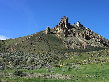
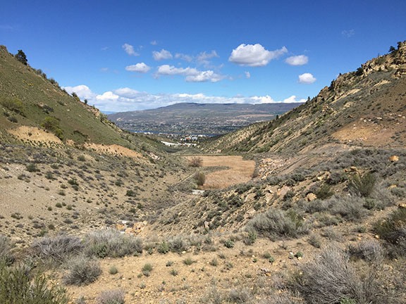
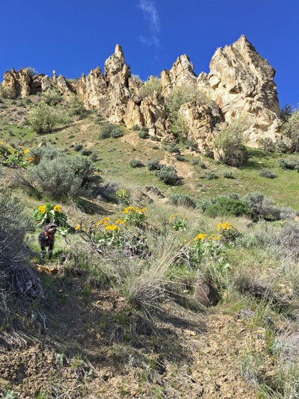
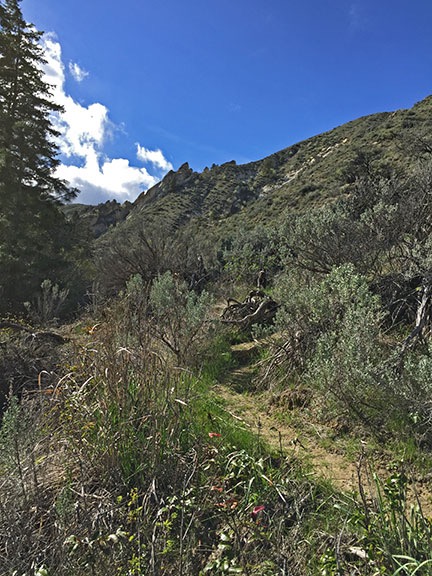
The trail continued as a narrow ribbon up into the canyon past the point where we turned back.

By this time, I’d had enough of the hike. I was surprised I’d come as far as I did — even though I didn’t know at the time how far we’d walked. About a quarter mile into the hike back, I remembered to turn on my GPS tracker. When I turned it off back at the Jeep an hour later, it reported a total of 2.2 miles. That brings the total length of the hike up to about five miles. Whoa. Not bad for a first hike of the season.

It had been a great hike — just the right length for me on that day. It’s unfortunate that my favorite part of the trail required a mile-long uphill hike to reach. I’d like to find more trails like that with trailheads easier to get to. I can hike all day on level ground or even downhill, but uphill has always been a bit of a struggle for me.

After dropping off Sue, I drove home and took a nice, long soak in my tub. An hour later, I was dead asleep in a two-hour nap. Let’s see if that rest is enough to fight off this cold.