Amazingly beautiful weather makes this flight extra memorable.
I flew Santa in to a private home in Leavenworth yesterday. The family has a huge Christmas party every year and Santa always arrives by some sort of “unusual” transportation.
I was contracted about a month ago to do the flight. I got the address and, just last week, drove up with a friend to check the landing zone. I found a beautiful log home on the Wenatchee River with a huge front lawn near some other homes and an orchard. A perfect LZ.
I watched the weather closely all this week. In Arizona, weather was seldom an issue, but here, in Central Washington State, things are different. Sure, the late spring, summer, and early fall are usually full of clear days, but the other half of the year — this half of the year — is a different story. We could have one day after another of sun and blue skies or one day after another of fog or low clouds or even rain or snow. This week was forecasted to be one of those second kind of winter days, with rain or freezing rain or snow in the forecast almost every day. I watched Saturday’s forecast change almost hourly, it seemed.
When the day finally dawned, I saw what I’d been dreading: low clouds over Wenatchee with still air and an 80% chance of rain. Temperature would not be an issue — 38°F was forecasted. But when I went out to check the condition of my driveway, I found a mix of slush and ice, about 1/2 inch thick.
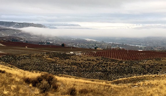
The view from my deck outside my bedroom door yesterday morning. At this point, it was flyable, but who knew what it would be like in 2 hours?
I texted my client and asked about conditions there. She reported back that it was overcast, but the clouds were at least 700 feet up. She said her son told her and he was a pilot. That was good news. I told her I’d keep watching and let her know if I had to cancel or postpone. I was supposed to pick up Santa at10:45 AM.
I went at my driveway with my snow shovel, scraping much of the slush to one side or the other. Then I grabbed the bag of ice-melt I’d bought some time ago, opened it, and spread about half of it on my driveway. Let science do the hard work. I watched the weather get better and then worse and then better over the next hour or so. I took a shower and dressed in black jeans with a red sweater — about as “holiday” as I get. Then I went into the garage and preflighted the helicopter.
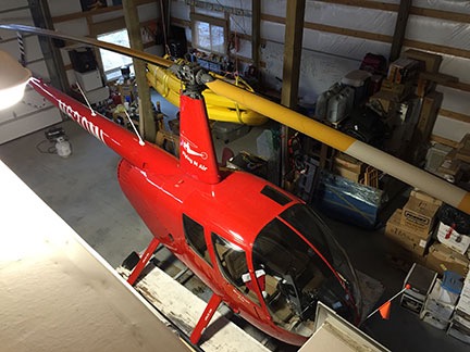
Here’s an unusual view of my helicopter in its parking space, shot from the roof of my RV when I happened to be up there the other day.
My garage temperature never drops below 30°F. It was about 40°F that morning — a lot warmer than my uninsulated hangar in Arizona would get on cold winter nights. Still, I’d put a battery charger on the helicopter that morning and disconnected it just before pulling it out. The battery is pretty new but I don’t fly very often in the winter and didn’t want to get stuck out on the platform with a helicopter that wouldn’t start while Santa was waiting. I disconnected all that, moved my space heater aside, and got the ATV’s engine going to warm it up. Then I opened the big garage door and pushed the helicopter out onto the driveway.
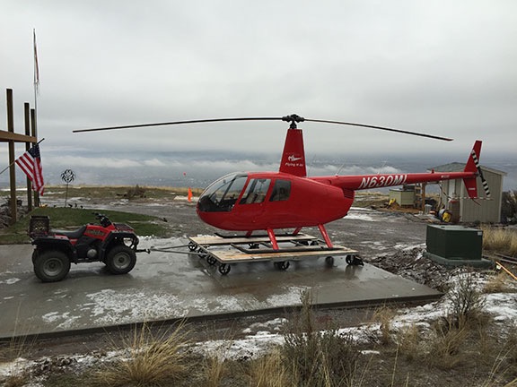
I uploaded this shot to Twitter with the comment, “Where’s Rudolph when you need him?”
Although I might have had enough fuel to do the flight, “might” is not good enough when you have to fly in questionable weather. I wanted at least 2 hours of fuel on board. That meant stopping at the airport to top off the main tank before heading up to Cashmere. I could see the airport beyond the low clouds, so I knew I could make it there. I put away my flag, closed up the garage, locked the door, and climbed on board. The helicopter started on the first try. It was apparently more eager to fly than I was.
Pangborn Airport (EAT) is a 3-1/2 minute flight from my home. At an elevation of 1249 feet, it’s about 400 feet below my home’s elevation. I departed over the orchards to the north, ducked down under a broken cloud layer over the river, and climbed back up to the airport. I crossed the approach end of runway 30 and landed at the fuel island. As I fueled, I noticed how bright it was out to the west in the direction I was going. The sun was out there, not even 10 miles away. Things looked good for my flight.
Here are some of the photos I took along the way. Somehow, my phone’s camera got switched to square photos, so that’s all I have.
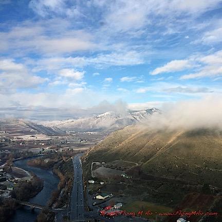
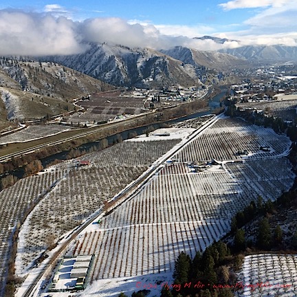
I finished fueling, started back up, and headed west. I flew over East Wenatchee and then downtown Wenatchee, past Pybus Market where I’d be bringing Santa the next day. Then I was flying over a ridge at Horselake Road and the Wenatchee River Valley was before me.
It was beautiful.
The sun was out but wispy low clouds floated here and there, sometimes tangled in the trees in the mountain foothills. There was fresh snow on the ground and in the pines. The sky was blue and the shadows of the clouds added a certain texture to the scenery that made it seem more alive than ever.
I turned on my phone and took some photos right through the plexiglas bubble. Taking photos while flying a helicopter isn’t easy, which is why I so seldom do it. I was kicking myself in the butt (figuratively, of course) for not setting up the GoPro nosecam, but with the weather so iffy back home, I never expected such beautiful scenery.
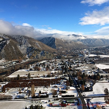
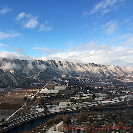
It was a 10-minute flight to Cashmere Airport. I set down alongside the taxiway in about an inch of slushy snow. I couldn’t believe how beautiful the mountains around me looked and couldn’t wait to get out and take a proper photo.
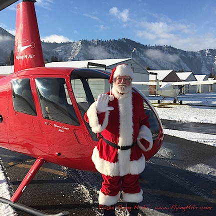
Santa poses outside my helicopter at Cashmere Airport.
I’d just shut down the engine when Santa showed up, driven by his cousin. We introduced ourselves and his cousin drove away. He had at least a 15-minute drive to get back to Leavenworth so he could watch us land. I took a photo of Santa outside the helicopter, gave him a preflight briefing, and helped him get in. (I don’t know why Santas need to be fat, but the pillows most use are a real pain in the butt when strapping into a helicopter.)
We were running early and I didn’t want to land before schedule. Santa suggested a little tour and since my client was paying for a full hour, I thought that was reasonable. I started up and took off along the runway, tracing a leisurely flight through Cashmere, past Dryden, and up near Peshastin. At exactly 11 AM, about 3 miles away from the landing zone, I headed inbound.
We flew right past the place, as we both knew we would. I circled back, found it, and then made a descending circle so Santa could wave at the crowd. And what a crowd there was! There had to be at least 100 people down there, all standing at the end of the landing zone waving up at us.
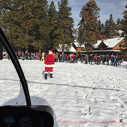
Santa’s arrival from my seat as I shut down the helicopter.
I made my approach between two pine trees and settled down into the snow-covered grass. Then I helped Santa release his seatbelt and open his door. He stepped out and headed toward the crowd while spectators waved and took photos. It was a really fun scene.
I shut down the helicopter and used the rotor brake to bring the rotor blades to a stop. Although my primary purpose for shutting down was to get paid, I didn’t see any reason not to let folks get a closer look at the helicopter. Although most parents and small kids headed inside with Santa, at least 50 people remained behind. As I climbed out, they came around the helicopter for photos. I let kids climb into my seat so their parents could take photos through the open door or plexiglas bubble. I handed out Flying M Air postcards (which feature an air-to-air photo of the helicopter over Lake Pleasant) and answered questions. Lots of people thanked me. My client gave me a check and a hug.
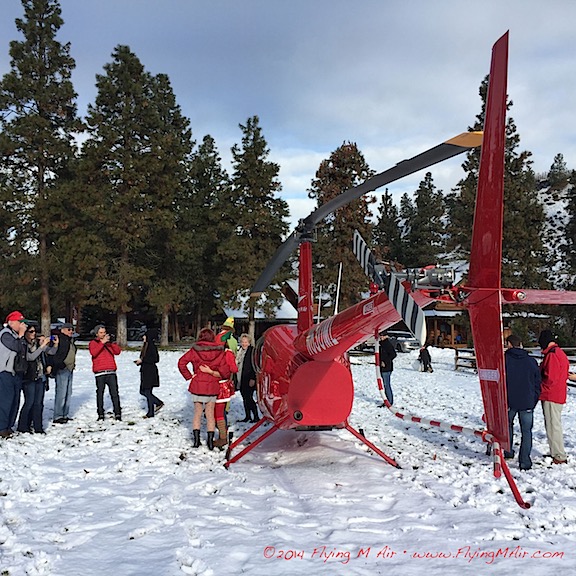
It was a fun scene at Santa’s destination. By the time I took this photo, most of the spectators had gone inside.
I felt really good flying back to Wenatchee and home — despite the weather that awaited me there. It was just as overcast and gray as when I’d left. The fog, although thickening, was not too thick to find my home. I made a nice, slow approach to my landing pad, set down gently, and adjusted its position while I was still light on the skids. I shut down and locked the blades in the forward/aft position before getting out. A few minutes later, I was backing the ATV into the big garage. I got the helicopter lined up perfect on my first try and pulled the big door closed behind it.
An hour later, the fog was so thick I could see only whiteness through my windows. It would be a few hours before it cleared out again.
Got my fingers crossed for Sunday’s flight. So far, it’s looking pretty much the same.