The Flying M Aerie on Google

Finally!

Yesterday, I was looking up something on Google Maps and was thrilled to discover that they’d finally updated the satellite image in for my area to include my home. I can’t be sure of the exact date, but I estimate that this shot was from sometime in the spring, before things had really greened up and gardens had begun to grow.

I cropped the image to my exact property lines — on the east, north, and west, anyway. The southern boundary of my property is the road, so everything above (north) of the road is mine. It’s 10 acres.

My property, annotated
Here’s an annotated satellite view of my property; everything above (north of) the road is mine.

A few notes:

  • When giving people directions to my home, I tell them it’s two miles down the gravel road, on the left with the big green roof. Most people can’t miss it — unless they use Google Maps, which either directs them to the airport (for reasons I can’t quite understand) or to the house across the street two doors back from me. Yes, Google got the address wrong.
  • Lookout Point is where I’ve put a bench for looking out over the valley. My property drops off quite steeply just north of that. It offers sweeping views from the Mission Ridge Ski Resort southwest to the mouth of Rock Island Creek to the northeast.
  • Chicken coop is where my chickens live. I’ve just redone it for the third (and hopefully last) time. I have five hens and a rooster but hope to expand my flock in the spring.
  • I’m going to be planting a few more fruit trees near my home. So far, I have two struggling cherry trees, which were given to me by one of my clients. I think the grasshoppers took a real toll on them. I have enough room in that cleared out spot for about five fruit trees: cherry, apple, pear, and apricot. I’ll plant in the spring. Irrigation is already there.
  • The bee yard is on the far east end of my property where the property lines make it very narrow. Although they used to be much closer to my home, the east end is more convenient for road access. But the real reason I chose that spot is because it gets the most sun; with the cliffs to the south, direct sunlight is scarce in winter. The farther north you go, the more sunlight there is. This is a perfect spot.

I had an irrigation system installed earlier this month. It runs in two zones down my entire 1100 feet of road frontage. Last week, workers planted 25 Scouler’s Willow trees to the west of my driveway. This will give me privacy from the road and help keep the dust down. Because they are native willows, they require less water than the Austian willows so popular here. They’re only about 2-3 feet tall now, but they should grow to 30 feet or more, likely within 5 years.

On the east road frontage, I’ll be planting Ponderosa pine (which grow naturally in the cliffs) and aspen (which many of my neighbors have planted) in grove-like bunches. These trees, also on irrigation, will grow very tall very fast. I’m hoping they’ll help teach my black-hearted neighbors, whose house appears in the lower right of the satellite image above, how to mind their business. They should probably take lots of photos of their view now, before those native trees block it.

(On a side note, I never realized how close my neighbor’s house is to the talus basalt rocks at the base of the cliffs to the south. Hell, one good rock slide and their backyard will be full of boulders. Who would build so close to such a hazard, especially with all the talk of earthquakes possible in the Pacific Northwest? City slickers, I guess.)

One of the nice things about having so much undeveloped land is how much can be done with it. My five-year plan calls for planting either a small vineyard or orchard in the area between the bee yard and my driveway. I’m thinking of devoting 2-3 acres to it. There are a few hurdles I have to jump first, though. No rush — I have plenty of time to move forward — and it’s a hell of a lot easier to do when I don’t have to compromise with a cheap, risk-adverse “partner” every step of the way.

Old Satellite Image
Bing Maps still has an old satellite image of the area. This is the same crop shown above; you can barely see my driveway. Based on the construction status of my neighbor’s home, I think this one might be about three years old.

And on that note, isn’t it amazing to see what I’ve accomplished since buying this lot back in late July 2013? Back then, the only thing I had was a partial driveway. Now I’ve got a home. It took a lot of hard work and money to make it happen, but it’s been worth it.

You Can’t Get There from Here

Another Apple Maps fail.

I’m planning a trip to Pullman, WA next Thursday to attend a beekeeping seminar. I got the street address of the college campus building I need to go to in an email message. Under OS X Mavericks, I can point to the address to display a map of its location, like this:

Address in Email

I clicked the Open in Maps link to open the location in the Maps application that comes with Mavericks. Then, because I was curious about how long it would take to make the drive, I clicked the Directions button in Maps. I filled in my current location in the Start box and Maps recognized it as my current location. Then I clicked Directions.

Here’s the result:

Maps Fail

If you can’t read the note on the right, here’s what it says:

Directions Not Available
Directions cannot be found between these locations.

Of course, when I went to Google Maps and plugged the same info in, I got complete directions:

Google Maps

Hello, Apple? How about leaving the mapping to the experts? I never asked for Apple Maps on my phone, iPad, or desktop computer.

The apps you provide with the OS are like tools for getting a specific job done. When you provide tools that don’t work, it’s like reaching for a hammer and having it break when you need to bang in a nail.

An(other) Apple Maps Fail

This example was so outrageous, I had to share it.

I spent last weekend in California with friends. (Blog post to come, eventually.) On Friday, they needed to take care of business in the Folsom area. We decided to have lunch while we were out.

My friends are not smartphone people, although one of them does have an iPod Touch that she uses with various apps on WiFi. In an effort to show how useful a smartphone could be, I used Apple Maps and my preferred navigation app, MapQuest, to navigate to their primary destination. It worked like a charm.

Google AppAfterwards, I used the Google Search app to perform a voice search (on my iPhone 4; no Siri) for “restaurants serving breakfast in Folsom California.” The app understood me perfectly and displayed a list of results. We decided on the Sutter Street Grill. The entry for the restaurant included its address as a link, as you can see in the screenshot. I tapped the link to view the location in Apple Maps.

Apple Maps ExampleAnd that’s where things got weird. It showed me the location on the map, but no matter how far I zoomed out, I could not see the dot representing our current location. And then I realized that the body of water on the map was a lot bigger than the lake we’d driven by.

Apple Maps Example
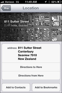
I tapped the arrow beside the location on the map. And that’s when I discovered that the map was showing us a location in New Zealand.

Here’s where I see a problem. I’m in California. The phone knows I’m in California. Yet when I tapped the address, it displayed a location on the other side of the planet.

And no, the location wasn’t incorrect in the link — although the street name does not include the word “historic.” For some reason that I can’t understand, Apple Maps decided to display 811 Sutter Street in Canterbury Seaview, New Zealand, 7,111 miles away, instead of the 811 Sutter Street that was less than 5 miles away.

Come on, Apple. Firing people isn’t going to fix the problem. Let’s get down to business and make this app work right.

By the way…the restaurant was great!