Icicle Creek Hiking

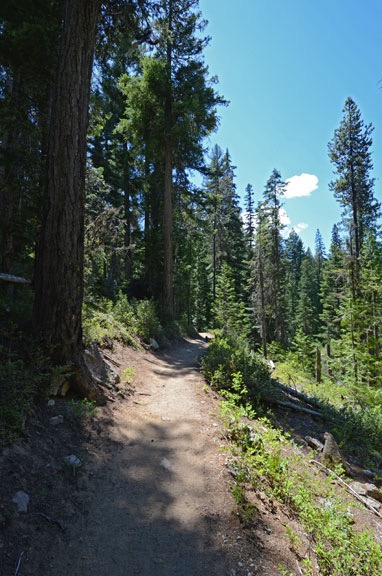
Hiking in the woods in the Icicle Creek drainage.

I really enjoy hiking — but with some limitations. I can hike all day on relatively flat terrain. If the hike has a climb, I prefer that the climb be at the beginning of the hike with the descent at the end. I’m easily winded on uphill climbs — and have been like that all my life, even when I was young and super slim — but have absolutely no trouble going downhill. On hot days, I prefer hiking in areas with at least partial shade. On cold days, put me out in the sun.
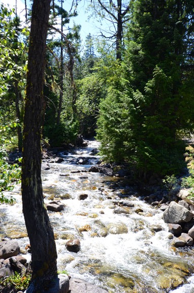
Icicle Gorge Trail

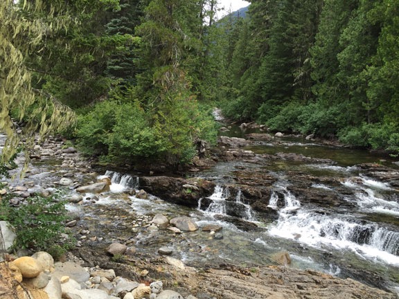
A few weeks ago, Kirk and I did the Icicle Gorge loop trail. That’s up Icicle Creek, not far from Leavenworth. The trail winds through forest and clearing, mostly following Icicle Creek. The water was still running pretty good, the creek fed by meltoff from snowpack and small glaciers up in the east side of the Cascade Mountains. It thunders through several narrow channels along the streambed — the gorge of the trail’s name.

Icicle Gorge Trail
The trail wound along the side of the creek, fringed with tall pines and wildflowers.

This was my second time hiking the trail. It’s just the kind of trail I like for a summer hike, with gentle uphill and downhill climbs, mostly in the shade of tall pine and other trees with a handful of open grassy meadows along the way. I’d done it the year before with my friend Alyse.

We got on the loop heading downstream first, crossing a footbridge at a narrow part of the gorge. From there, we headed back upstream. At first, we were along Icicle Creek, but the trail moves away from the creek, into the forest. At one point, it winds up to the top of a small hill with a monument that overlooks a bend in the creek. Then it descends back down to the creek, crossing Trout Creek not far when it meets Icicle.

Trout Creek
The trail crosses Trout Creek at a small footbridge in the forest.

We stopped along the creek for a snack of nuts and fruit and energy bars. The rocks there were worn by centuries of water flow, with some carved pockets filled with stagnant water. The sound of the rushing creek was oddly calming.

Swimming Hole
Just downstream from this bridge was a deep swimming hole just perfect for a refreshing dip.

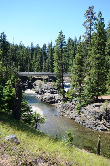
The trail crossed Icicle Creek again at the Chatter Creek campground. There’s an auto bridge there and beneath it, a cascade feeding a deep swimming hole. We climbed down onto the rocks bordering the deepest part. A few people were farther downstream, at a sandbar that helped hold the water back.

I threw Penny in to cool her and pulled her out when she swam ashore; after that, she wouldn’t stay with us. (I had to put her on a leash a while later, just to keep her near.)

Kirk changed into his swimming trucks and wasted no time diving in. I was a little tougher to convince. I hadn’t brought a bathing suit. But after a while, I decided that the water looked too good to pass up. I stripped off my shorts and went in in my panties, tank top, and sport bra. The water was delightful — deep, clean, and refreshing. Probably the best swimming hole I’d ever been to.

Indian Paintbrush
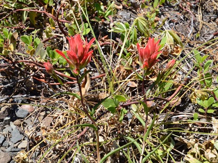
Indian Paintbrush is one of many wildflowers we spotted along the trail.

After our swim, we got back on the trail and continued the loop. We were on the return trip now. The trail wound mostly through dense woods, coming very close a few times to the gravel road that led to the campground. I’d brought along my Nikon with its 10-24mm lens and took some photos of flowers and tiny waterfalls along the way.

We were back in the parking area about three hours after we’d started the hike. We’d walked a leisurely 4 miles or so. A great hike I’d definitely do again — especially on a hot summer day. Next time, I’ll wear a swimsuit under my shorts.

Icicle Creek Trail

Tiny Creek
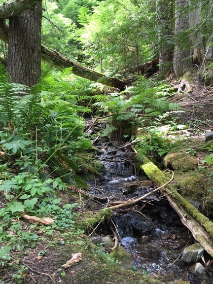
We crossed this tiny creek on our hike. The forest was dense and cool.

On Friday, Kirk and I went out to Icicle Creek again. This time, we hiked a trail he’d done before, the Icicle Creek Trail. The trailhead can be found at the very end of the same road we’d taken to get to the Icicle Gorge loop trail.

This is an out-and-back trail that winds through dense forest, gently climbing and descending as it goes. Its name is misleading — it doesn’t actually follow the creek. Instead, it cuts through the woods, crossing a handful of tiny creeks, with the sound of Icicle Creek off in the distance. Eventually, it joins Icicle at its confluence with French Creek.

The walk was pleasant, although I regretted my choice of attire — shorts and tank top — because an overcast made it chilly down in the woods. Not exactly cold, but not warm, either. The kind of day when sunlight would have been welcome. I let the GPS in my phone keep track of our trail, but tucked away in the pocket of my cargo shorts as we hiked in a canyon, it had trouble keeping track of where we were. As a result, the track was jagged with its length likely overstated. At the end of the hike, it said we’d gone nearly five miles, but I don’t think we went much more than four.

Fishing at Icicle Creek
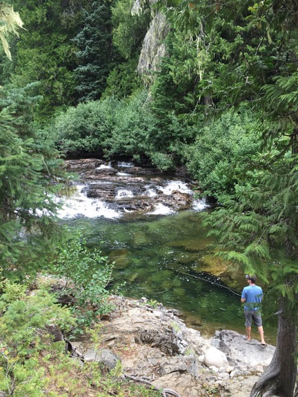
One of the campers was fly fishing just downstream from the French/Icicle confluence.

We saw signs of horses — there’s a horse camp and a horse trailer parking area not far from the trailhead — but no horses. No wildlife either.

The sound of the creek got louder and louder until we reached it. There are two campsites there, one on either side of the creek, and a family had set up camp in one of them. A man and girl were fishing in the creek while a woman and another child were walking creekside not far away. French Creek met Icicle Creek right there, with water rushing together from both creeks in a jumble of rocks.

French/Icicle Confluence
The confluence of French (left) and Icicle (right) creeks.

We hung out for a short while, then continued on the trail. A “Stock Crossing” sign marked where horseback riders could cross French Creek. There was a good, strong bridge a bit farther down the trail. I found myself telling Kirk about my horses and how Cherokee couldn’t be made to cross that bridge but Jake would have no trouble at all. (I miss my horses, but not enough to have horses again, despite the fact that I have plenty of room to keep them at my home.)

Kirk on a Log
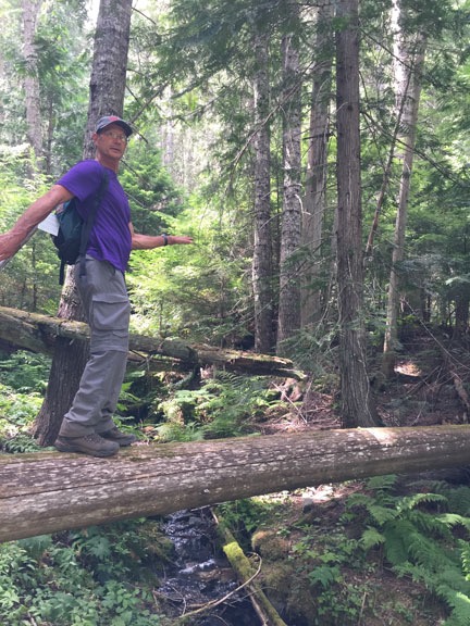
Kirk clowning around on a log across one of the tiny creeks.

We didn’t walk much farther. Not only was I getting cold as the overcast continued to thicken, but I was concerned about the possibility of rainfall over orchard I’m under contract to protect. There was no cell phone service where I was and no clear look at the sky back toward Wenatchee. On top of all that, I had a meeting near home at 5 PM. So after only an hour on the trail, we turned around and headed back.

Kirk dutifully picked up a few pieces of trash — a beer can and a Starbucks cup (if you can believe that) — along the way. I think I’ll be bringing bags for this job on future hikes. I can’t believe how people can be such pigs.

Back at the trailhead, we loaded the Jeep back up and retraced our route back toward Leavenworth. We had just enough time for lunch at Sleeping Lady before I had to hurry home.

Would I do the hike again? Definitely. But next time, I’ll bring a change of clothes and a better lunch. I’d very much like to see what’s farther up that trail.

A Flight with Santa

Amazingly beautiful weather makes this flight extra memorable.

I flew Santa in to a private home in Leavenworth yesterday. The family has a huge Christmas party every year and Santa always arrives by some sort of “unusual” transportation.

I was contracted about a month ago to do the flight. I got the address and, just last week, drove up with a friend to check the landing zone. I found a beautiful log home on the Wenatchee River with a huge front lawn near some other homes and an orchard. A perfect LZ.

I watched the weather closely all this week. In Arizona, weather was seldom an issue, but here, in Central Washington State, things are different. Sure, the late spring, summer, and early fall are usually full of clear days, but the other half of the year — this half of the year — is a different story. We could have one day after another of sun and blue skies or one day after another of fog or low clouds or even rain or snow. This week was forecasted to be one of those second kind of winter days, with rain or freezing rain or snow in the forecast almost every day. I watched Saturday’s forecast change almost hourly, it seemed.

When the day finally dawned, I saw what I’d been dreading: low clouds over Wenatchee with still air and an 80% chance of rain. Temperature would not be an issue — 38°F was forecasted. But when I went out to check the condition of my driveway, I found a mix of slush and ice, about 1/2 inch thick.

Deck View
The view from my deck outside my bedroom door yesterday morning. At this point, it was flyable, but who knew what it would be like in 2 hours?

I texted my client and asked about conditions there. She reported back that it was overcast, but the clouds were at least 700 feet up. She said her son told her and he was a pilot. That was good news. I told her I’d keep watching and let her know if I had to cancel or postpone. I was supposed to pick up Santa at10:45 AM.

I went at my driveway with my snow shovel, scraping much of the slush to one side or the other. Then I grabbed the bag of ice-melt I’d bought some time ago, opened it, and spread about half of it on my driveway. Let science do the hard work. I watched the weather get better and then worse and then better over the next hour or so. I took a shower and dressed in black jeans with a red sweater — about as “holiday” as I get. Then I went into the garage and preflighted the helicopter.

Helicopter from Above
Here’s an unusual view of my helicopter in its parking space, shot from the roof of my RV when I happened to be up there the other day.

My garage temperature never drops below 30°F. It was about 40°F that morning — a lot warmer than my uninsulated hangar in Arizona would get on cold winter nights. Still, I’d put a battery charger on the helicopter that morning and disconnected it just before pulling it out. The battery is pretty new but I don’t fly very often in the winter and didn’t want to get stuck out on the platform with a helicopter that wouldn’t start while Santa was waiting. I disconnected all that, moved my space heater aside, and got the ATV’s engine going to warm it up. Then I opened the big garage door and pushed the helicopter out onto the driveway.

Helicopter on Driveway
I uploaded this shot to Twitter with the comment, “Where’s Rudolph when you need him?”

Although I might have had enough fuel to do the flight, “might” is not good enough when you have to fly in questionable weather. I wanted at least 2 hours of fuel on board. That meant stopping at the airport to top off the main tank before heading up to Cashmere. I could see the airport beyond the low clouds, so I knew I could make it there. I put away my flag, closed up the garage, locked the door, and climbed on board. The helicopter started on the first try. It was apparently more eager to fly than I was.

Pangborn Airport (EAT) is a 3-1/2 minute flight from my home. At an elevation of 1249 feet, it’s about 400 feet below my home’s elevation. I departed over the orchards to the north, ducked down under a broken cloud layer over the river, and climbed back up to the airport. I crossed the approach end of runway 30 and landed at the fuel island. As I fueled, I noticed how bright it was out to the west in the direction I was going. The sun was out there, not even 10 miles away. Things looked good for my flight.

Monitor from the Air
Orchard West of Cashmere
Cashmere
More Cashmere
Here are some of the photos I took along the way. Somehow, my phone’s camera got switched to square photos, so that’s all I have.

I finished fueling, started back up, and headed west. I flew over East Wenatchee and then downtown Wenatchee, past Pybus Market where I’d be bringing Santa the next day. Then I was flying over a ridge at Horselake Road and the Wenatchee River Valley was before me.

It was beautiful.

The sun was out but wispy low clouds floated here and there, sometimes tangled in the trees in the mountain foothills. There was fresh snow on the ground and in the pines. The sky was blue and the shadows of the clouds added a certain texture to the scenery that made it seem more alive than ever.

I turned on my phone and took some photos right through the plexiglas bubble. Taking photos while flying a helicopter isn’t easy, which is why I so seldom do it. I was kicking myself in the butt (figuratively, of course) for not setting up the GoPro nosecam, but with the weather so iffy back home, I never expected such beautiful scenery.

It was a 10-minute flight to Cashmere Airport. I set down alongside the taxiway in about an inch of slushy snow. I couldn’t believe how beautiful the mountains around me looked and couldn’t wait to get out and take a proper photo.

Santa
Santa poses outside my helicopter at Cashmere Airport.

I’d just shut down the engine when Santa showed up, driven by his cousin. We introduced ourselves and his cousin drove away. He had at least a 15-minute drive to get back to Leavenworth so he could watch us land. I took a photo of Santa outside the helicopter, gave him a preflight briefing, and helped him get in. (I don’t know why Santas need to be fat, but the pillows most use are a real pain in the butt when strapping into a helicopter.)

We were running early and I didn’t want to land before schedule. Santa suggested a little tour and since my client was paying for a full hour, I thought that was reasonable. I started up and took off along the runway, tracing a leisurely flight through Cashmere, past Dryden, and up near Peshastin. At exactly 11 AM, about 3 miles away from the landing zone, I headed inbound.

We flew right past the place, as we both knew we would. I circled back, found it, and then made a descending circle so Santa could wave at the crowd. And what a crowd there was! There had to be at least 100 people down there, all standing at the end of the landing zone waving up at us.

Santa Arrives
Santa’s arrival from my seat as I shut down the helicopter.

I made my approach between two pine trees and settled down into the snow-covered grass. Then I helped Santa release his seatbelt and open his door. He stepped out and headed toward the crowd while spectators waved and took photos. It was a really fun scene.

I shut down the helicopter and used the rotor brake to bring the rotor blades to a stop. Although my primary purpose for shutting down was to get paid, I didn’t see any reason not to let folks get a closer look at the helicopter. Although most parents and small kids headed inside with Santa, at least 50 people remained behind. As I climbed out, they came around the helicopter for photos. I let kids climb into my seat so their parents could take photos through the open door or plexiglas bubble. I handed out Flying M Air postcards (which feature an air-to-air photo of the helicopter over Lake Pleasant) and answered questions. Lots of people thanked me. My client gave me a check and a hug.

At Santa's Destination
It was a fun scene at Santa’s destination. By the time I took this photo, most of the spectators had gone inside.

I felt really good flying back to Wenatchee and home — despite the weather that awaited me there. It was just as overcast and gray as when I’d left. The fog, although thickening, was not too thick to find my home. I made a nice, slow approach to my landing pad, set down gently, and adjusted its position while I was still light on the skids. I shut down and locked the blades in the forward/aft position before getting out. A few minutes later, I was backing the ATV into the big garage. I got the helicopter lined up perfect on my first try and pulled the big door closed behind it.

An hour later, the fog was so thick I could see only whiteness through my windows. It would be a few hours before it cleared out again.

Got my fingers crossed for Sunday’s flight. So far, it’s looking pretty much the same.