The End is Near

The end of my cherry drying contracts, that is.

I came to Washington State in the beginning of June to start a pair of cherry drying contracts. I was fortunate enough to get a third contract wedged in between the first two, giving me almost seven solid weeks of work.

Well, “work” is not quite an accurate term. I was on standby for all three contracts, but only flew 5.2 hours on two days during one contract.

Thank heaven I was getting standby pay. Without it, I would have taken a heavy loss this summer. But with it, and thanks to the availability of a pilot willing to share ferry costs on both 10+ hour flights between Washington and Arizona, I’ll stay in the black.

My third contract officially ends on Monday, July 28 at nightfall. Unless the weather looks threatening, they’ll likely cut me loose a few hours earlier. It doesn’t matter. I’m not leaving until Tuesday.

But in the meantime, I figured it might be a good idea to drive my orchards, just to see if there was still fruit on the trees. I was in Wenatchee today, so I drove past the one near Wenatchee Airport. There are two cherry orchards across the street from each other. I’m not sure which one is mine. (Heck, it’s hard to tell from the ground when all the photos I have are from the air!) One of them still had plenty of cherries, the other had none. I continued on to Quincy and visited two of my three orchards there. Both were heavy with cherries. One of them is likely to be picked soon — fruit boxes had been laid out neatly in the rows between the trees.

As long as there’s fruit on the trees, there’s a slight chance they’ll ask me to stay on. Although I don’t mind staying an extra day or two, I really don’t want to stay longer than that. I feel done with this place, if you know what I mean.

My trip home will be completed in multiple steps:

  • Tuesday: Fly the helicopter from Quincy to Seattle. Then take Horizon back to Wenatchee and drive back to Quincy. I hope to get all that done on Tuesday, but might have to take an early morning flight on Wednesday to get back to Quincy.
  • Wednesday: Drive the trailer to Walla Walla. That Washington town consistently comes up as a top choice when I go through the quiz on the Find Your Spot Web site. I was there in 2006 during my Midlife Crisis Road Trip and I liked what I saw. But I was only there long enough to do my laundry and visit a downtown independent bookstore. This time, I’ll stay two nights and check it out.
  • Friday: Drive the trailer from Walla Walla to Salt Lake City. I’ll be staying with the family of one of my editors, Megg. She’s going to take me hiking on Saturday.
  • Saturday: Drive the trailer from Salt Lake City to Page, AZ. If I get a late start from SLC, I’ll spend the night on the road and get in sometime on Sunday.
  • Monday: Fly in Mike’s plane from Page, AZ to Wickenburg. I need to get Alex the Bird home.
  • Friday: Fly with Mike on US Air from Phoenix to Seattle.
  • Saturday-Sunday: Fly with Mike and another pilot from Seattle to Page, AZ. I’m hoping to spend the night in the Reading area, where a buddy of mine is on a fire contract. I think we’d all get a lot out of seeing how a fire operation works.

I still have four chapters of a book revision to finish. I goofed off in Wenatchee most of today, but I expect to finish up over the weekend. There’s another book right after it, but I’ll get that started when I get back to Wickenburg and finish it when I settle down in Page.

Cherry Drying on Google Earth

Putting the tracks on a satellite image.

I had my handheld GPS (a Garmin GPSmap 60c) running while I was drying cherries and the GPS tracked my movements. Today, on a whim, I saved the tracklogs and downloaded them to my Mac. Then I brought them into Google Earth and looked at a few of the orchards.

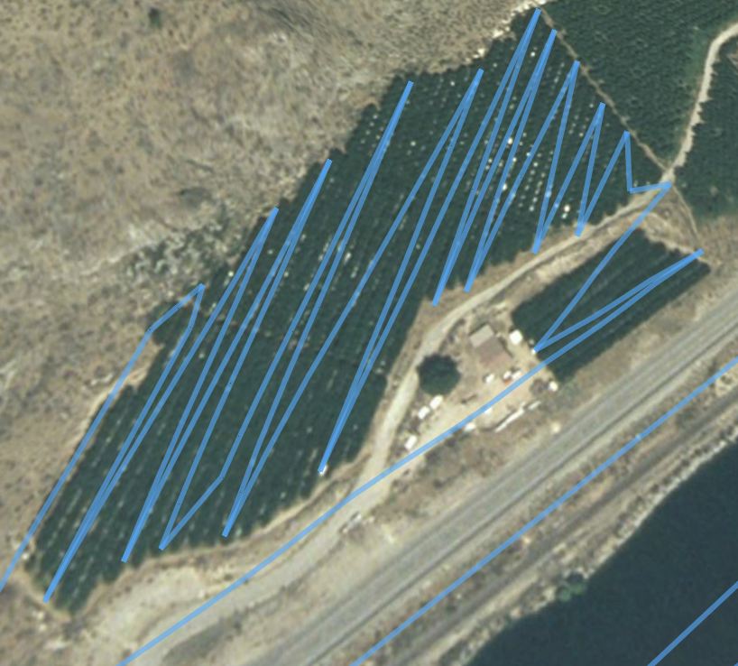
The tracks are not very accurate. They show a zig-zag motion that appears to cross diagonally across the rows. In reality, when I reached the end of each row, I moved to the side and turned to go down another row. So rather than pointed endings and diagonal tracks, an accurate rendering would show squared off endings and parallel tracks.

But I still think it’s interesting to see how I moved over the land. Take a look and see for yourself. These are the tracks from my flights on July 4.

In this first example, I’d flown past the orchard on the south side from west to east, then circled back. I made a wide clockwise circle of the orchard to get my bearings, then came in on the south end, near a white single-wide mobile home. There was a woman there, waving happily when I arrived. She’d left the door of her house open and I blew a bunch of leaves into it. (Oops.) My track took me back and forth up the triangular orchard. Although the track makes it look as if I had a short row near the top, it’s just another inaccuracy in the track. I departed the area with a clockwise circle to the west.

Cherry Drying Tracks

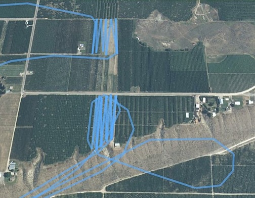
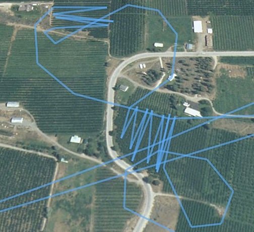
Here are two others representing three dries. I went to the lower one first, passing it by on the south from west to east. I circled back, then came in on the southwest corner. I went back and forth from west to east, then broke off. It started to rain so I repositioned to the airport, which was less than a mile away. I read for a while, then got a call with a new list of orchards. I started back up and took off, returning to re-dry the lower orchard in this image again (hence the double set of track lines) after doing others a bit farther to the west. I did the upper orchard about an hour later, coming in from the northwest and departing from the southeast side back to the west.

Cherry Drying Tracks

Here’s a sloppy looking one that really wasn’t this sloppy. I did the lower orchard first, coming in from the southeast and departing out the northwest. I then went directly to the upper orchard, beginning the dry at the southwest and exiting at the northwest. The pair of diagonal lines going across the bottom of this screenshot represent overflights of the orchard on my way to or from the ones in the previous screenshot.

Cherry Drying Tracks

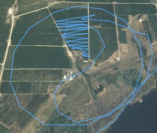
This is the first orchard I described in some detail in my “I Dry Cherries” post. Again, I really didn’t fly a zig-zag pattern in the main orchard. and I’m certain I flew at least two more rows (one in each direction) in the smaller orchard. But the GPS doesn’t seem to pick up all the points when it makes its tracks. The two other straight lines near the bottom right of the image are overflights to/from other orchards. That’s the Columbia River/Lake Pateros in the bottom right corner of the shot.

Cherry Drying 4.jpg

These are just a few of the orchards. You get the idea. Next time I fly, I’ll use my new geotagger. It can save up to 600,000 waypoints (I think) so I have a feeling the pictures it draws will be a lot more accurate. If they are, I’ll show them off here again.

We all know what a geek I can be.

Unemployment Lasts Just Two Days

My contract ends and I get another.

My first round of cherry drying contracts went…well, I guess it went well. They were two-week contracts. It rained only two days, but not enough to launch me. So I spent 12 out of 14 days just hanging around and exploring the area. I only spent 2 days prepping the helicopter and remaining on “active” standby. Still, I collected standby pay for all 14 days.

I feel only a little bit guilty for collecting money without doing any real work. After all, because I was required to be in the area with the helicopter, I couldn’t do any other paying work with it. So the compensation is partially for possible work lost. The rest is to cover my expenses, some of which are quite substantial — think insurance and travel costs and that damn fuel tank and the helmet I have yet to wear while flying.

But the first round of contracts ended at sundown on Monday. And my next round of contracts wasn’t due to begin until July 8. That meant I had two full weeks with no potential income and a lot of time on my hands.

It was like being unemployed.

I made a few phone calls yesterday and today. I got a few back. And one of them was an offer for a new contract that would run from June 26 (Thursday) through July 7. A fill-in contract. I jumped on it. So I’d enjoy my unemployment for a total of two days.

The new contract is up in Brewster, WA. That’s about 100 road miles from here but only 50 nautical air miles from here. I can get there in 30 minutes by helicopter, according to Duats flight planning.

Sectional Chart around Brewster, WA

But I’m not moving my camper from Quincy. After all, I have to return for that July 8 contract. My camper is all settled in and the campsite and Internet are paid for. The campground’s full hookup sites are all filled and I know that if I move my camper, someone else will steal my site, despite the fact that it’s paid for. Besides, this area is due for a heat wave starting on Saturday. I’d much rather suffer through that in a motel than in the camper. The camper’s air conditioning works fine, but it makes a hell of a racket.

The motel I’m going to is in Pateros. It’s right on the Columbia River and all the rooms look out that way. They allow pets, so Alex the Bird won’t need to be hidden — although he will cost me an extra $10/day. There’s even a pool. And, if you can believe this, they’ll let me park my helicopter on the grass to the east of the building.

Mike is flying up on Friday. He made his plans yesterday, when we both thought I’d be down here in Quincy, twiddling my thumbs for two weeks. His timing couldn’t be better. He’ll drive the truck up for me on Saturday morning, with Alex the Bird and his rather bulky cage.

Then, on July 7, when Mike is gone, I’ll have to figure out how to get everything back to Quincy for the next three week gig.