How I learn the importance of having a fire extinguisher on board.
Saturday, February 7, 2004 was a typical Arizona winter day. Temperatures in the 60s, clear skies, light winds. Mike was working at the airport until 2 pm, when we expected a furniture delivery. The monthly airport barbeque was set up by 11:30 when I decided to take a trip down to the place I planned to do some desert barnstorming the following day.
A few weeks before, Janet and I had done some desert barnstorming in Tristan’s R44 helicopter, north of Carefree Highway, west of Lake Pleasant where some ATVers had gathered to ride on the trails. We didn’t do very well — we just did one ride for three people — but one of the people told us that there was a big motorcross scheduled for February 8. They told us that if we came back then, we’d be able to do lots of rides.
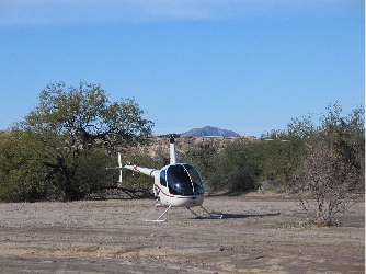
I decided to check things out the day before. Since my helicopter is a heck of a lot cheaper to fly than Tristan’s, I fired it up and headed east.
Things were really hopping when I got there. The place was full of trailers and dirt bikes and a huge red and white striped tent had been set up not far from a good landing zone. I set Three-Niner-Lima down and kept an eye out while I shut down. When the blades had stopped, I made my way to the big tent.
There was a lot of activity in the area. Dirt bikes rolled by, stirring up clouds of dust. Vendors selling all kinds of dirt bike paraphernalia had set up shop under canopies alongside the dirt road. There was even a food vendor with a smoker.
The huge tent was almost empty. Tables had been set up around the perimeter, but there wasn’t much going on at any of them. In the back was a table with two computers and a few guys staring at them. I walked back and introduced myself.
Oddly enough, one of the guys at the computers was one of the three people who’d flown with me a few weeks before. He remembered me and called over someone else who was a decision maker. She was thrilled to see me. She told me she was supposed to call me and had forgotten. She was glad I’d come. Of course I could do rides. She called over another boss person and told him. He was busy but seemed mildly interested. He said he’d announce the rides at the dinner that night. I offered three free rides for a raffle and promised to return the next day with my ground crew.
It was nearly 1 pm when I returned to Three-Niner-Lima. I’d promised Mike I’d be back by 1:30 so I could go home and await the furniture. I checked the oil, walked around to look for obvious tampering, and climbed aboard. Then I went through my all-too-familiar ritual of starting up.
I put my headset on, leaving my right ear uncovered. I pushed the mixture full rich. I turned on the master switch. I opened my door and called out “Clear!”, making sure it really was clear. Then I turned the key to start and started the engine. Flicked the Clutch, Strobe, and Alternator switches. Checked to make sure I had good oil pressure and that the starter light was out. The blade started turning. Then I turned on the avionics in the usual order: transponder, radio, GPS.
“Pop!”
The sound was new, something I’d never heard before. I distinctly remember saying “That’s odd,” to myself. “I wonder what that is?” Then I looked at the instrument panel and saw the puff of smoke on the passenger side, right beside the GPS.
Smoke.
I cut the throttle, flicked the clutch off, and pulled the mixture. The engine died. I remembered my fire emergency procedures and flicked off all switches, then turned the fuel selector to off. I opened my door and stepped outside, looking anxiously in the cabin I’d just vacated.
Fortunately, nothing was on fire. The smoke dissipated, leaving an electical fire smell behind.
I waited to be sure that nothing was on fire. Then I thought about my situation. Parked out in the desert, about 20 miles from home. Furniture due to arrive in an hour. Mike would be pissed.
But hell, my helicopter could be on fire!
But it wasn’t.
I remembered my emergency kit, which I kept under my seat. I dug it out. It has a very nice Swiss Army tool in it. With a screwdriver that I could use to open the instrument panel for a peek inside.
I was unscrewing the panel when a man rode up on his ATV. I told him my situation as I worked. He told me he was an electrician. (How could I get so lucky?) He helped me open the panel. I swung it back and we peered inside. No trace of any problem. No trace of burning, smoke, or anything else. Surprisingly, not even much dust.
Not satisfied, I decided to remove the panel covering my avionics. We had four screws out when we realized that there would be at least eight screws and we’d need a microscopic allen wrench to get the knob off my radio. That wasn’t a job to do out in the desert. So we closed it back up.
He asked me if I had a fire extinguisher. I told him I didn’t. He told me he’d get me one and took off on his ATV.
I called Mike and told him the situation. I couldn’t stand next to the helicopter while I was on the phone. The signal was bad there. I had to walk 20 feet away. I told him what had happen and what I’d done. I told him I planned to start up the ship with the circuit breakers for the avionics pulled. If that worked, I’d fly home. But I wouldn’t have any radios, so he should start making radio calls for me in about 20 minutes, warning area pilots that a helicopter without radios was on its way in.
The man on the ATV returned with a small fire extinguisher. He told me it belonged to the people serving food and made me promise to bring it back. I promised. I also promised to give him a helicopter ride the next day. I studied the instructions on the fire extinguisher and stowed it on the passenger side floor. Then I climbed back on board and he rode away. I pulled out the Pilot Operating Handbook and read the Fire procedures in the Emergency Procedures section, just to make sure I knew them very well.
I pulled the two avionics circuit breakers and the one for the avionics fan. I figured that if there was a fire in there, the last thing I needed was a fan blowing air on it. Then I went through my startup ritual (see above), skipping the part where I turn on the avionics. The blades were spinning when I realized that I was hearing a rhythmic clicking sound I don’t think I’d ever heard before. Although there was no smoke, the sound spooked me. I turned everything off again.
Now I was desperate. I wasn’t sure if the helicopter was safe to fly, but I didn’t know what to do. I called MIke again and gave him an update. He started making plans for coming to pick me up. Then I told him I’d call Paul Mansfield.
Paul Mansfield was my mechanic. He’s probably one of the best Robinson Helicopter mechanics out there. Unfortunately, due to a disagreement between me and the company he works for, I’m not allowed to bring my helicopter to him for servicing. I wasn’t very happy about this and neither was he. He told me that if I ever had a problem, I could call him. He even gave me his cell phone number.
Throughout the past three years or so, I’ve called him about four times. He’s been very helpful. I called him that day. He answered. I told my story. When I got to the part about the smoke, he said what I’d been thinking at the time: “That’s not good.” I was glad we agreed on that point.
He thought the problem might be in the strobe, which I’d turned on right before the avionics and had turned on the second time I’d started, too. The rhythmic clicking sound could correspond to the charging mechanism. He thought I might be hearing it through my headset. He suggested that I leave the strobe off and give it a try. I thanked him and hung up.
I called Mike to give him an update. By now, it was almost 1:30. I was going to be late — if I ever made it at all.
I climbed aboard again and pulled two more circuit breakers: the strobe and the intercom (what the heck; who was I going to talk to anyway?). I started it up. The clicking was gone. There was no smoke. Everything was fine.
Of course, a ton of stuff wasn’t even turned on.
I took off cautiously, my eyes straying occasionally to where I’d seen the smoke and the fire extinguisher lying on the floor beyond it. I flew low for two reasons. First, without a radio, I wouldn’t be able to announce my position to anyone. I was far less likely to encounter someone at 400 feet AGL than higher. Second, I wanted to be close to the ground in case I needed to land in a hurry. Let’s face it, the closer you are to the ground, the quicker you’ll get there.
I also decided not to take the quickest route home, which went across the mostly flat and definitely empty desert. If I had to land, I wanted to land where some people would see me and be able to help — or at least give me a ride to civilization. So I followed Carefree Highway and, when I reached it, Grand Avenue.
My Bose headset, which has excellent noise cancellation features, completely stinks when it isn’t powered up. I’d unplugged it before taking off, so it offered very little sound muffling. The helicopter was very loud and I imagined that every noise was a new one, one that could mean trouble. But there was no trouble. I flew into Wickenburg, flying only about 300 feet above the ground so I’d remain clear of any traffic in the pattern or departing the area. Then I made an approach from the south to the helipad. It was 1:50 PM when I set down.
Mike was busy fueling helicopters: a Schweitzer 300 and a Robinson R22. I wanted to look at the Schweitzer, but didn’t have time. I hopped in my Jeep and went home. The furniture guys arrived five minutes after I did. Mike arrived ten minutes later.
On Monday, my local mechanic, Ed, took apart the instrument panel and removed the avionics. The GPS had faint singe marks on it, but when we removed it from its case, its circuits were okay. He reassembled everything and we powered up the avionics stack. No popping noises, no smoke. Everything fully functioning.
I hate when that happens.
Ed thinks there might have been a loose screw or something inside the stack. It hit the GPS case and caused a little short circuit, complete with smoke, but didn’t pop the circuit breaker. Then the helicopter’s vibrations shook the screw into a place where it couldn’t be found. A place where it wouldn’t pop again.
I hope Ed is right and that there’s no more smoke in my cockpit.
Since then, I’ve flown more than 6 hours in Three-Niner-Lima — now nicknamed “Smokey” — and haven’t had any problems at all. It went to Prescott for a 100-hour inspection and Cody, the mechanic there, couldn’t find any problems either.
But I bought Three-Niner-Lima a present from the Robinson Helicopter Company: its very own fire extinguisher.
 I looked for a place to land and found a large, clear area in the middle of the wash. It had rained several days before and had snowed up in the mountains. Areas of the was were still wet. I set down on a high, sandy area where the sand looked packed. I lowered the collective slowly once I’d touched down, watching my skid sink into the sand. It sunk in about an inch. Mike said there was no sink on his side. Satisfied, I shut down.
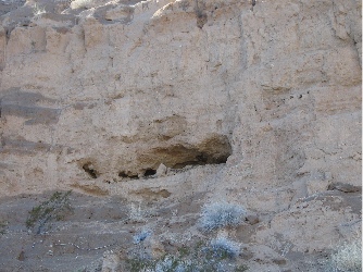 At the base of the cliff, I stopped to take a photo of the cave. It looked very promising. In fact, I was sure I could see signs of a manmade wall inside the cave.
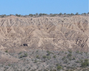 Disappointed, we made our way back down the hill. We stopped on a sunny spot and ate lunch, admiring the view across the wash, where years of erosion had eaten away the cliffs.
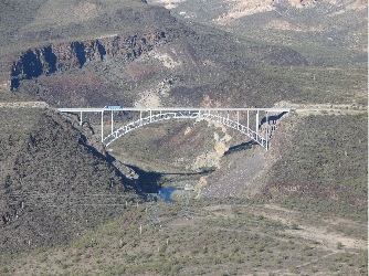 We followed the river east to route 93 and explored some of the rock formations there. Some people on ATVs looked up at us as we flew over. Then we headed up the road to Burro Creek. Mike wanted to see the campground from the air; we were thinking about spending a few days there at the end of the month. He shot these two excellent photos. The bridge over Burro Creek. (Yes, it is possible to fly under the bridge, but we didn’t do it that day. The bridge isn’t the problem; the power lines, which hang lower than the bridge, are what’s scary.)
 I wrote about my first landing at the Kofa Cafe in an article for wickenburg-az.com’s Day Trips section. I liked the restaurant’s big servings and down-to-earth atmosphere. I liked all the junk out on the front porch and in the yard. I liked eating with the truckers. I liked taking the helicopter someplace that wasn’t on an airport but didn’t get me in trouble. Three-Niner-Lima parked in the truck parking area the first time I visited the Kofa Cafe. The Cafe is the blue building.