Our Government In Action: Commercial Drone Pilot Rating Edition

How much more inconvenient can they make it?

Mavic Pro
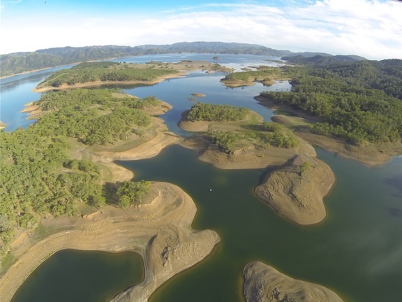
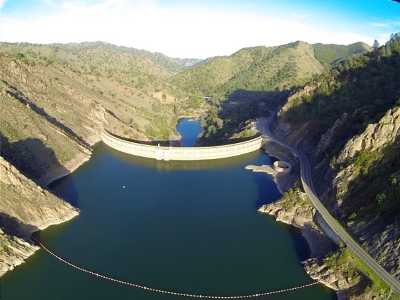
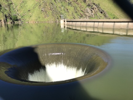
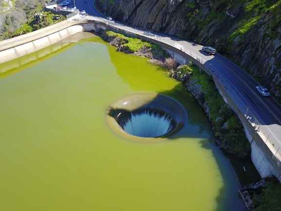
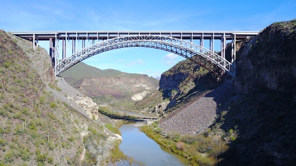
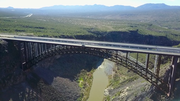
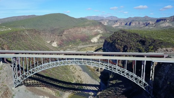
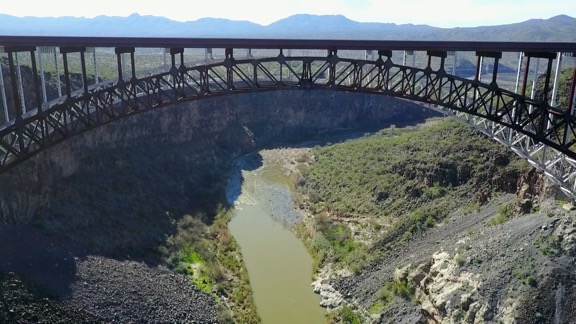
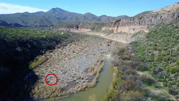
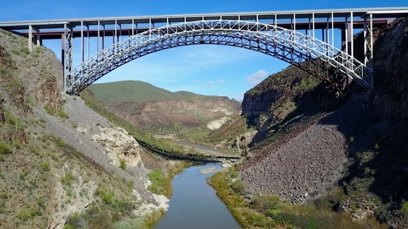
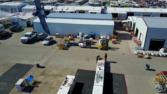
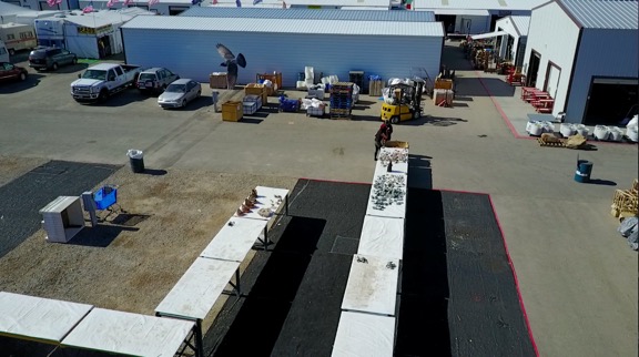
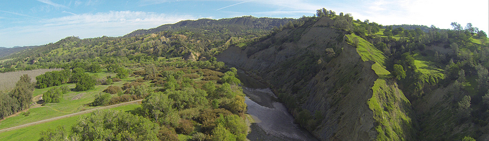
My flying camera takes amazing still and video photos.

Regular readers of this blog might know that I bought a Mavic Pro flying camera back in January 2017. Before spending the money, I did my homework on FAR Part 107, which sets forth rules and regulations for commercial sUAS (small Unmanned Aerial Systems, AKA drones) operations. The certification process was pretty simple for existing pilots: study the rules, take an online training course, pass the test at the end of the course, and submit an application to the FAA for the sUAS rating to be added to my existing pilot certificate. I did all of this on December 20, 2016.

I fully expected to get some kind of correspondence from the FAA in the mail. Although some of my mail was forwarded to me while I was traveling this winter, not all of it was. Still, I didn’t get anything from the FAA for this in my forwarded mail or the mail held for me at home. Nothing.

Yesterday, I revisited the process, certain that I had neglected to do something. I followed the trail of multiple websites to find the place where I had filled in my application. I logged in and reviewed the application, which was dated 12/20/16 with a status of “Submitted by Applicant.” There were no additional instructions or useful information to tell me what I needed to do next or whether my application was even being processed.

I made four phone calls. Eventually, I got a guy at the FAA’s Spokane FSDO (Flight Standards District Office). For those of you unfamiliar with that kind of FAA office, its basically a regional office handling local FAA matters like aircraft and pilot certifications and airport operations. He told me that all I had to do was take my printed application to the FSDO and have someone there check my ID. They could then print out a certificate.

I wasn’t sure I’d heard him right. I had to drive to Spokane — which is 3 hours away by car — and show my driver’s license to someone in the office to prove I was who I said I was? So I’d need to spend six hours of my day, plus whatever time it took in Spokane, just to verify my identity?

Yep. Or I could go to the Seattle FSDO in Renton, WA (also 3 hours each way). Or the Portland FSDO in Hillsboro, OR (5-1/2 hour each way).

Of course, if I knew a DPE (Designated Pilot Examiner) who was closer, I could pay him to verify my identity and let him submit the paperwork. Although the FAA guy didn’t say this, I knew what would happen next: the paperwork would disappear into a black hole at the FAA for another three months.

As you might imagine, this completely floors me. In the past few years, I have made numerous very large banking and real estate transactions, each of which required positive identification, entirely via the Internet. Hangar sale, house sale, land sale, loan applications, wire transfers. Transactions worth hundreds of thousands of dollars in total, all requiring that I be identified before completing the transaction.

Why is it that the banks and title companies I worked with were able to verify my identity online when the FAA — which already has the name, address, phone number, and social security number associated with my existing pilot certificate — can’t?

Part 107 Explained
Want to become a commercial drone pilot? Start by learning all about the FAA’s Part 107. This book will help. Buy the ebook edition on Amazon or from Apple. Or buy the paperback edition on Amazon.

Apparently, it’s because the FAA treats this as a brand new pilot certificate instead of an add-on rating. It doesn’t matter that they know who I am because they meet up with me at least once a year for my Part 135 certificate. I still have to jump through this ridiculous and meaningless hoop.

Just to get a piece of paper to make my commercial drone pilot operations legal. In the meantime, hundreds, if not thousands, of drone pilots are out there doing the same kind of work that I want to do without any kind of certification. Heck, I’m willing to bet that at least half of them haven’t even bothered to register their drones.

Is there any wonder why people break the rules? Could it be because the rules are ridiculous and cumbersome to follow?

So today I’ll pull my little Honda out of the garage. I’ll gas it up in town and hit the highway. I’ll drive all the way to Spokane and visit the fine folks in the FSDO there. They’ll look at my license and they’ll check a few boxes on the form I’ve printed out for their convenience. Then they’ll go into a back room and punch some keys on a computer keyboard. Moments later, a piece of paper — my temporary certificate, I guess? — will come out of a printer. They’ll hand it to me and I’ll begin the long drive back home, stopping for gas again along the way.

A whole day of my time blown.

In a few weeks (or months?), I’ll get a new plastic card from the FAA’s main office in Oklahoma. I’ll slip it in to my wallet with my existing pilot certificate — another card to carry around all the time.

But at least I’ll be legal to do commercial drone photography. That’s a lot more than I can say about a lot of the other drone pilots out there.

Lake Berryessa and the Glory Hole

Not something you see every day.

I spent a few weeks in the Sacramento area of California — as I have been since 2013 when I brought my helicopter there for its first frost control contract — in late February and early March. I’ve gotten to know the area pretty well over the past five years and as I continue to explore new places, I also return to the old ones. Lake Berryessa, the largest lake in Napa County, is one of these places.

I first discovered it during a drive up Putah Creek, starting in Winters, CA. From there, I made a stop at the Lake Solano Campground (which I eventually stayed at for the first time this year) and noted its crazy collection of peacocks. Farther up the road, I passed numerous parking areas for fishing and hiking and picnicking. Still farther, the road crossed the creek, wound up a hill, and passed the Monticello Dam, which holds in the waters of Lake Berryessa. Penny and I have hiked in various places along the shore, driven much of the west side’s shoreline, and even flown over it numerous times in my helicopter.

Aerial View of Lake Berryesssa
An aerial view of Lake Berryessa, shot with a GoPro on my helicopter back in March 2014. The water was very low.

For the first four years I’ve been in the area, the lake level was low — very low. This isn’t surprising given the serious drought that affected nearly all of California. All of the lakes I flew over were low. But this year things were different. This year, all the lakes are full, nearly full, or even — in some cases — overflowing. Lake Berryessa is one of the lakes with too much water.

Man-made lakes — basically, any lake that holds water in with a dam — usually have flood control features built in that guide excess water safely out of the lake and into a receiving stream or river. This is normally done with the use of a spillway that can be opened or is automatically utilized before the water level reaches the top of the dam.

Spillways come in different styles. The most common is a sort of water chute that excess water flows down, away from the dam. Most dams have this kind of spillway. The Oroville Dam, which has been in the news a lot lately, has spillways like this, one of which was severely damaged by floodwaters.

Another less common type is an open bell mouth spillway. That’s the type at Lake Berryessa. It’s a round concrete hole not far from the road and the dam. From Wikipedia:

Near the dam on the southeast side of the reservoir is an open bell-mouth spillway, 72 feet (22 m) in diameter, which is known as the Glory Hole. The pipe has a straight drop of 200 feet (61 m), and the diameter shrinks down to about 28 feet (8.5 m). The spillway has a maximum capacity of 48,000 cfs (1360 cms). The spillway operates when there is excess water in the reservoir; in 2017 after heavy rains it started flowing, for the first time since 2006.

Monticello Dam w/Glory Hole
In looking through my archive of photos from 2014, I found a GoPro photo of the dam from the air that clearly shows the Glory Hole when it isn’t in use.

It was in the news in February because the lake had finally filled, after 11 years, and water was flowing into the Glory Hole. Of course, I had to go see it. So when I got the helicopter into California and needed to a “maintenance flight” to check a few things, I headed over there. Sure enough, water was flowing into the hole and a small gathering of people along the road were looking in. I flew by a week later and the water was still flowing in.

I wanted to see it again from the ground, so I returned on Saturday. By that time, Penny and I were on our way home from nearly four months on the road so I had the Turtleback on my truck. Once again, I’m so glad I downgraded from my big fifth wheel; parking in the very crowded parking area was remarkably easy.

There were a lot of people there. It was, after all, Saturday and the Glory Hole had been on the news quite a bit. It made a good, easy, and free point of interest for sightseers.

Glory Hole from the Road
The Glory Hole, photographed from the road. That’s the dam to the right. The water is pretty close to the top.

Penny and I joined the crowd and walked along the road for a good look. The chain link fence made it difficult to get a good photo. The hole is right next to the road and pretty much fills the camera lens. But I did my best.

A guy was out there with a Phantom 4 drone so I decided to give my drone (AKA flying camera) a shot when he was done. I went pack to the truck, put Penny inside, and pulled out my drone. Within about 5 minutes, I had it all set up in a clear area between parked cars and the fence downstream from the dam. When I was sure the other drone had landed, I launched mine.

Understand that I’m still learning how to use my Mavic Pro. I’m also very careful. Immediately after launching, I took it up over the lake, away from people. Then I captured some still and video shots of the Glory Hole from the air, including a short pass where I flew directly over the hole with the camera pointing straight down.

Glory Hole from the Air
I really don’t know why the water looks so green in this shot. I don’t think it’s the camera. It must be something to do with the light.

I tweeted the video clip and got a lot of positive feedback about it. I also got a request to contact the folks at a video licensing company who want to represent me on the resale of the clip to news other media organizations. I’ll all for that, provided my FAA Commercial UAS Pilot certificate has come through; it’s not legal to sell drone photography without it. Need to get home and check my mail to see if the paperwork is there; I applied back in January so I should be good.

I need more practice using my Mavic and I intend to get some on my way home. I had it out again this morning from my campsite at Bodega Bay. I’m hoping to put together a little montage when I get home and share it here on the blog. Stay tuned.

Congratulations! You’ve made it to the end of yet another lengthy blog post here on An Eclectic Mind. If you got this far, you must have gotten something out of what you read. And isn’t it nice to read Web content that isn’t full of annoying ads?

How about doing something to show your appreciation? I’d love it if you’d add a comment at the end of this post to share your feedback with me and others. But I’d really love it if you’d visit my Support page and chip in a few dollars to help cover the cost of hosting this blog and motivate me to keep writing new, interesting content. It’ll only take a moment and I really would appreciate it!


DJI Sales Support Experience Update

This is a total fail.

Back in January, I blogged about ordering a Mavic flying camera from DJI, a company with plenty of slick marketing materials that make it look as if they have a significant U.S. presence but apparently operate 100% in China. At about the time I had my lengthy online chat with DJI’s support people, I also sent an email message to them asking about the status of my order.

That was January 9, 2017.

On February 13, 2017 — yes, five full weeks later — I got the following response from them:

DJI Support Email

Of course, by this point, I’d already gotten my Mavic. In fact, I got it less than two weeks after my email message to them. It just took them 5 weeks to send me a canned response that provided no help and certainly proved they hadn’t looked into my support request at all.

I’m not the only one who is amazed at the complete lack of sales support from DJI. My friend Jim, who saw and liked my Mavic, decided to buy one, too. He ordered from DJI and was originally told it would ship out within a few days. Later, they changed that to a few weeks. He cancelled the order and ordered from Amazon instead. He’ll have it by the end of the week.

I can’t knock the product. The Mavic is an amazing tool for aerial photography and videography that’s incredibly easy to fly. I blogged a bit about it here. But the quality of sales support by DJI is dismal.

With so many customers in the U.S., would it kill them to open a call center with access to sales info to help its new customers? They must be absolutely raking in the dough on these things — they’re not cheap.

And are we going to be similarly served if anything goes wrong with our Mavics and we need technical support under our extended warranties? I sure hope not.

Return to Burro Creek

And another [safer] flight under the bridge.

Back in November 2014, I blogged about the time I was in a helicopter that flew under the Burro Creek Bridge on Route 93 at Burro Creek. It was probably on my mind back then as I was reviewing log book entries for a book I’m working on about my flying experiences. I just re-read that post and I do recommend it. It’s short — for me, anyway — and tells an interesting story that gives you some insight into the minds of helicopter owners and pilots.

Burro Creek Bridge
Plenty of room to fly under, no?

Anyway, yesterday I drove north on Route 93, starting my annual migration from my snowbirding stay in Arizona to my late winter/early spring work site in the Sacramento area of California. (Yes, my seven-month “vacation” is nearly over.) I gave myself about 10 days to make the trip and planned stops along the Colorado River near the Hoover Dam, Death Valley, and possibly Lake Tahoe. Or the California Coast. I don’t really know yet. One of the things I like most about my life these days is my unfettered ability to make and change plans on the spur of the moment.

I’d been thinking about the drive for a while, wondering what stops I could make along the way. Burro Creek was a no-brainer. There’s a BLM campground down along the creek about a mile or so off Route 93. I’d considered stopping there for an overnight stay on my way south from Vegas in November but had ultimately chosen a different route that kept me on the Colorado River. The campground isn’t much — in fact, the water is turned off there so the bathrooms are closed up and I’m not even sure if you’re allowed to use the dump station — but it does have ramadas (shade structures) at each campsite, along with picnic tables and a nice desert garden. And plenty of hiking opportunities.

Burro Creek Bridge
A view back toward the campground, looking southwest. That’s Route 93 south of the bridge in the distance.

Burro Creek Campground is about an hour north of Wickenburg, which is where I’d spent the previous two nights. Perfect timing for a break on my estimated three hour drive to Willow Beach on the Colorado River near Hoover Dam. I pulled in, drove down the cracked asphalt road to the campground, and parked in the day use area so the campground host wouldn’t try to hit me up for camping fees.

The Burro Creek Bridge — or should I say bridges? — is clearly visible from the campground. It’s a pair of two-lane truss arch bridges that are about 680 feet long about 390 feet over the floor of Burro Creek’s canyon. The first bridge was built back in 1966 and carried all northbound and southbound traffic. In 2005, as part of route 93’s widening project, they built a second almost identical span right beside it. The new bridge now handles northbound traffic while the old bridge handles southbound traffic. I’m glad they built a matching bridge. It really helps preserve the aesthetics.

Burro Creek Bridge
The two bridges are nearly identical, despite being built 40 years apart.

(A side note here: Route 93 between Wickenburg and I-40 near Kingman had the local nickname “Death Highway” because of the number of deadly accidents — often head-on collisions — that occurred there when it was just one lane in each direction. Widening it was long overdue since it handles nearly all auto and truck traffic between Phoenix and Las Vegas. Parts of it are still one lane in each direction. You can learn more about Route 93 in Arizona on Wikipedia.)

I had done a photo shoot of the new bridge back in 2005 with an aerial photography professional. It was a memorable flight, mostly because he did the shoot with a pair of Hassalblad medium format film cameras. These are extremely costly cameras and the reason he had two of them was so that when he finished shooting a roll of film, he could switch to the other camera instead of fumbling at an open aircraft door to reload film. I think each roll only had 12 shots. I distinctly recall hearing the mechanical sound of the shutter and his manual winding of the film though the intercom system since the microphone was so close to the camera. I orbited the bridges several times. I know he was disappointed with our timing; the second span wasn’t quite done but yet it wasn’t open enough to be dramatic. There was just a narrow gap maybe 50 feet wide in the middle of the roadway. We should have arrived about two weeks before for a more dramatic shot or two weeks afterward for a completed span.

I was thinking a lot about that photo shoot as I walked down to the creek with my Mavic Pro flying camera tucked away in my day pack. The construction company — or Arizona Department of Transportation? — had flown the photographer in to Phoenix from somewhere in the midwest for the shoot. He’d rented a car and drove to Wickenburg. I flew him up there with the doors on, then landed in the construction area to pull off his door and stow it in the back seat. We’d done the flight, circling around and and around. It was midday, but there were still shadows because of the angle of the sun in the deep canyon. I’d landed again to put the door back on and then we’d headed back to Wickenburg. The only reason we hadn’t done the whole flight with the door off was because I could get better speed in transit with the door on and it was at least a 30-minute flight. I’m thinking the whole job was about 1.5 hours of billable flight time, but without consulting my logbook, I can’t be sure. Total cost of those photos? Easily a few thousand dollars.

Burro Creek Bridges
Really. Nearly identical.

I walked as far as I could — at least a half mile — getting almost under the power lines that spanned the canyon just southwest of the bridge. I was hoping to be on the other side of them so I wouldn’t have to worry about them interfering with drone operations, but Burro Creek was running full and fast and I’d gone as far as I could without getting too close to the canyon wall. I spread out my collapsable landing pad in one of the few boulder-free areas, and got to work setting up the Mavic and its controller for flight. I have it down to a science at this point and it only takes me about five minutes from the moment I take it out of the bag to the moment everything is powered up and the Mavic is in GPS mode.

Mavic Operator
I grabbed this image of the video on the Mavic’s return flight. I circled where I’m standing with the landing pad. You can see the campground behind me.

I couldn’t tell how far above the canyon floor the power lines were. I knew they were lower than the bridge, but I also knew that we’d flown under them. They had to be at least 100 feet up. Still, when I launched the Mavic I kept it just 50 feet up until I knew it was on the other side of the wires. (I now estimate they’re at least 150 feet feet from the canyon floor, but likely more than 200.)

I spent the next half hour or so flying around near the bridge. I flew over it once and under it three times. I didn’t want it to distract drivers on the road, so didn’t fly anywhere where the average driver would see it. I had to bump up the maximum altitude for the flight over the bridge, but I figured that was okay because I was still within 400 feet of either the bridge roadway or canyon walls. Certainly nowhere where a manned aircraft should be flying — although I think I’ve already established that it was where a manned aircraft could be flying.

Burro Creek Bridge
This photo was shot from under the power lines.

I switched batteries after two flights and used up 20% of the second battery before finishing up. Penny had very patiently waited nearby. She doesn’t mind the drone or its bee-like buzzing but stays clear of the landing pad when it’s coming or going.

Part 107 Explained
Want to become a commercial drone pilot? Start by learning all about the FAA’s Part 107. This book will help. Buy the ebook edition on Amazon or from Apple. Or buy the paperback edition on Amazon.

When I was finished, I powered everything down, replaced the Mavic’s gyro lock and cover, and folded it up. Within a few minutes, I was ready for the return hike with everything stowed away in my day pack again.

I got a bunch of video shots, as well as some still shots. This blog post shows off mostly screen grabs from the video. Launching from the stream bed inside the canyon limited what I could do, keeping in mind that I had to keep the Mavic within sight during the flight (per FAA rules).

I think that if I’d launched from up alongside the roadway, level with the bridge, I could have gotten the same shots that Hassalblad photographer had captured twelve years before — for a lot less money. But there really wasn’t a good place to launch from that wouldn’t distract drivers. And it isn’t as if this was a real mission. It was just more practice.

I wonder what that Hassalblad photographer is doing these days. I seriously doubt he’s still using those cameras to take aerial photos.

Drone Pilots: Beware of Bird Strikes!

Just a quick warning, with photos.

Last week, I did a few photo missions with my Mavic Pro flying camera. For two of the msisions, I launched from an open area at the far east side of the Tyson Wells complex in Quartzsite, just south of Keuhn Road.

I’m in the habit of using the Return-to-Home feature of my Mavic to get it back to its launch point quickly and efficiently. In all honesty, I’m awed by its ability to land exactly on its takeoff spot nearly every single time. I like to watch, with my finger poised over the pause button on the control (just in case), as it comes to the right coordinates far overhead, turns to the direction in which it took off, and descends to the spot.

On one of the three missions I flew from that spot, a small flock of pigeons flew right past the Mavic. I watched in shock and a bit of horror as the five or six birds swooped around my fragile aircraft. I felt relief as the Mavic continued its descent unharmed, but the whole thing repeated itself when another flock — or the same flock? — swooped past. Again, the Mavic was unharmed.

I happened to have the video camera going when this was happening. Here are two screen grabs, one from each flight, that show the closest encounter. The first one was definitely closer.

Near Miss
This reminds me of a scene from The Birds.

Near Miss
The bird is a bit farther off in this one. Can you see it?

Of course, the camera can’t capture action in a direction it isn’t pointing. For all I know they could have come closer behind the camera.

Part 107 Explained
Want to become a commercial drone pilot? Start by learning all about the FAA’s Part 107. This book will help. Buy the ebook edition on Amazon or from Apple. Or buy the paperback edition on Amazon.

While this is all kind of cool in a weird sort of way, it wouldn’t have been so cool if one of those birds clipped a rotor. The Mavic has four independently powered rotors. If any one of them was destroyed, I’d have to think the whole thing would immediately go out of balance and crash. This is one good reason why we don’t fly drones over crowds of people. Even though the Mavic weighs in at less than 2 pounds, having one crash onto your head from 150 feet would definitely cause some injuries.

Honestly, I’m surprised this hasn’t happened yet. A matter of time?