Quicksand!

I went looking for quicksand yesterday afternoon — and found it.

Quicksand is quite common along the Hassayampa River in Wickenburg. The river runs mostly underground, in the sandy river bed. It comes to the surface in rocky areas, like around Box Canyon and south of town. It also flows on the surface when there’s a lot of water — like during or after a heavy rain.

It had rained earlier in the week and there was snow on the Bradshaw Mountains, where the Hassayampa has its source. The river was running too big to drive in. So we took Scenic Loop around to one of the few dirt roads that winds down to the river. We parked on a hill and hiked down to walk along the river’s edge.

One of the places quicksand likes to form is at the base of large rocks or cliffs that end in the water. The water flows downstream, hits these rocks, and makes a kind of eddy before it turns one way or the other and continues downstream. Where it makes the eddy, the sand gets soft. Very soft. There’s lots of water under it, so even though the sand looks firm on the surface, when you step into it, you’ll sink in.

I was exploring one of these areas on foot with my video camera on a monopod/walking stick. I was getting to the point where the sand was just a little soft and I stretched out my left foot to feel the next step ahead. It seemed firm enough, so I shifted my weight onto it. Bad move. I sunk in past my ankle. Thrown off balance, I put my walking stick down nearby. It also sunk in. Before I could fall forward into it, I threw myself backwards, landing on my butt in the soft, wet sand.

QuicksandFor a moment, I considered panicking. Then I realized how dumb that was and inched backwards on my butt, pulling my feet and walking stick with me. After a few moves, I was on firm enough sand to get back on my feet.

Right after my incident, Jack the Dog wandered into the same spot, chasing a bee. He reacted quickly and managed to get out without assistance — he’s been in quicksand before — but it was interesting to see the sand shift and recover its innocent appearance after he’d escaped.

The photo here was taken when we got home. My left foot is still wet and sandy; my right foot is dry and clean. Sorry — no photos of my sandy, wet butt.

Quicksand is a serious thing along the river and not to be taken lightly. If a vehicle drives into it, it can quickly be sucked down to the point where it can’t be pulled out.

As for the dry quicksand of television and movies — I don’t think it exists. This stuff is wet and clingy and sticks with you until you change your clothes.

PhotoJeeping: Mine Ruins on the Hassayampa River

Some photos from a real off-road experience.

This past Sunday, Mike and I took the Jeep up the Hassayampa River. Way up the river.

As folks around Wickenburg know, the Hassayampa is mostly dry. The water does flow year-round, but in most places, it’s below the sandy surface. In rocky areas, it flows above the surface as a small stream.

Unless it’s rainy (or has been rainy). Then it’s a real river and should not be driven in.

Our Route InOn Sunday, it was running only slightly higher than usual. We entered the riverbed near the end of Rincon Road, where it climbs up to meet Scenic Loop. There was an old manganese mine there and the dirt road is black. Going straight (instead of making the left turn) takes you on a narrow track to the river. From there, it’s just a matter of following the tire tracks left by other vehicles.

Slot Canyon
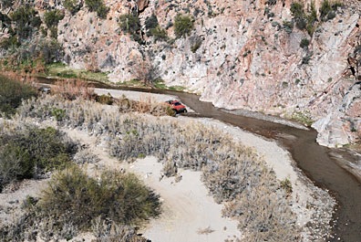
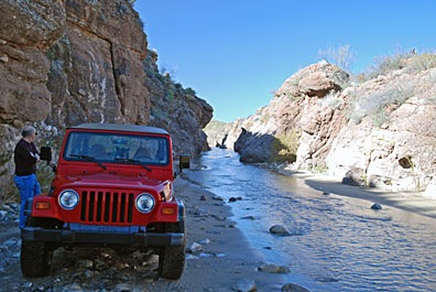
We made a few brief stops. Box Canyon was one of them. But there were motorcycles there with loud engines and we didn’t stay long. Instead, we continued upstream, into the narrow slot canyon. The water flowed from wall to wall within the canyon and I had the windshield wipers going as I slipped around in the soft sand. We stopped for a moment to take a photo of the way we’d come.

We passed through the first gate just short of Boyd Ranch, above the floodplain on our left. We passed through the second gate just before Fools Canyon. Right about there, a group of five sand rails (dune buggies) and a yellow Jeep caught up with us. (We weren’t rushing.) We pulled over to let them pass.

In many places, four wheel drive was required. So was high clearance. So unless you have a Jeep or similar vehicle or an ATV, this isn’t the kind of drive you’d want to make. You’re driving in the river, with water splashing up all around you, in many places. There’s quicksand there, so you want to keep moving anywhere the sand is soft. Gnarly tires are definitely a plus.

Desert Meets StreamWe passed many interesting spots where Sonoran desert meets year-round stream. The variations in the rock were amazing. I took quite a few photos. Some of them are in my Photo Gallery.

We were about two miles past Fools Canyon when the group that had passed us came back. One of the drivers stopped to report. “You can’t go much farther,” he said, “but it’s worth it. There are some old foundations up there.”

Mine Site
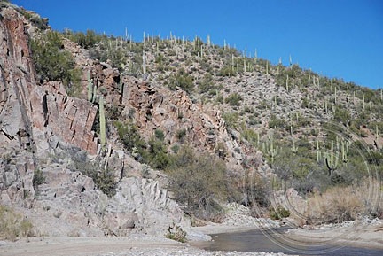
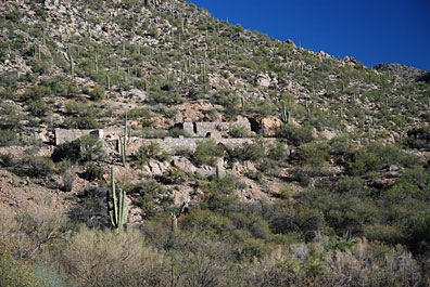
We continued on. The river was flowing through a canyon, but the way was still passable. We soon saw the remains of a mine site on the right side of the hill. We turned the Jeep into a promising canyon where other vehicles had driven but soon reached a dead end where rocks blocked our way. We parked, got out, and hiked up the hill.

It was an interesting mine site, with some seriously heavy-duty foundations. I don’t know much about mining, but I do know that they used gravity to process the ore. That’s what most of the “foundations” were for.

Tunnel
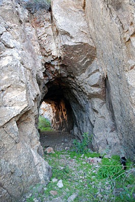
Following a narrow path for a better view down into the river, I came across a tunnel carved into the solid granite at the side of the hill. We passed through and continued onto the other side.

Mine RuinsA bit farther down the pathway, we found the remains of a wooden mining structure, as well as some partially buried railroad steel. Evidently, the path and tunnel had been used by ore carts or some similar conveyance. Most of the steel had been removed; the one piece we saw had been buried under a rockslide.

Truck in the River
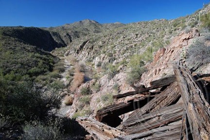
As we admired the view, we heard the sound of a vehicle. Down in the riverbed, a truck was driving downstream. It stopped only long enough for the driver to point out a mine shaft to his passenger, then continued on down the river. I don’t think they saw us or our Jeep.

We left a while later and spent a short time exploring the severely vandalized remains of a home across the river. Then we headed back, stopping long enough to take a few photos along the way.

We were gone about five hours and had covered about 40 miles roundtrip. We took Scenic Loop from just past Fools Canyon on the way back, minimizing our time in the riverbed.

I checked all the maps I have for the area and the mine does not appear on any of them, so I don’t know it’s name. I do know it well, however; I fly over it every time I take a tour up the Hassayampa River in my helicopter. It’s nice to know what it looks like close up.

PhotoJeeping: Off Constellation Road

Covering more miles of dirt and desert.

Yesterday, Jack the Dog and I took my Jeep out on Constellation Road. It’s a dirt road that winds into the desert northeast of Wickenburg, past numerous mining sites. It was named for the town of Constellation, which is on many maps. But I’d driven and flown the area extensively and cannot find a trace of the town where it is supposed to be.

Off Constellation RoadPhotoJeeping is like photowalking, but done in a Jeep. Sure, you get out and do some hiking now and then, but most transportation is by Jeep or other 4WD vehicle. I covered 40 miles yesterday, roundtrip, in about five hours. I made stops at a number of mining sites and more than a few “scenic” areas near the road. And, for the first time ever, I drove all the way out to the Williams Family Ranch on the Hassayampa River.

Along the way, I took plenty of photos — more than 150, in fact — and a bit of video.

This is one of the last photos I took on the way back. The light was getting good but I was exhausted. I really didn’t think I’d get back as quick as I did, but wasn’t interesting in hanging around for the light to get even better. This spot is about 8 miles out of Wickenburg, right at the beginning of the hills.

Photo Info:
Camera: Nikon D80
Focal Length: 35mm
Aperture: f/6.3
Shutter Speed: 1/160
Lat/Lon: 43.04841° / -112.6031767°

Photos from Our Flight to San Diego

The view from above.

In November, Mike and I took my helicopter to the San Diego area for business. The flights to and from San Diego were over some of the most interesting — and boring — desert terrain out there.

Our route to San Diego from Wickenburg (E25) took us southwest, skirting around the restricted area north of Yuma, where we landed for fuel. (Fuel there was $1.20/gallon cheaper than at my home base.) Then almost due west along I-8, over the Glamis Dunes and Imperial Valley, which lies below sea level. Finally, a climb over some mountains and a descent down to Gillespie Field (SEE).

On the return flight, we took a different route. We flew east along I-8, then northeast to the northern tip of the Salton Sea to Chiriaco Summit and then along I-10 to Blythe, where we refueled. (The fat guy is gone.) From there, we overflew Quartzsite before making a bee-line for Wickenburg.

You can see the approximate routes below; click the map for a larger view with readable labels.

Route of Flights

Mike’s got his private pilot certificate and 100 hours of flight time in helicopters, so he’s legal (per my insurance company) to fly passengers. So he did most of the flying. I had my door off for the Yuma to El Cajon part of the flight and took photos — mostly over the Glamis dunes. It was nice to be a passenger for a change — to be able to use my camera without left-handed contortions. I also had the POV.1 video going for part of the flight, although the sound crapped out part of the way.

Anyway, here are a few of the photos I took on the flight. You can find more of my aerial photos — as well as larger versions of these — in my photo gallery.

Glamis Sand DunesGlamis Sand Dunes

Formally known as the Algodones Dunes or the Imperial Sand Dunes Recreation Area, the Glamis Dunes is a huge series of sand dunes west of the Colorado River, northwest of Yuma, AZ in California. The dune field stretches 45 miles north to south and 6 miles east to West. This photo shows only a portion of the dunes, looking north from the I-8 area. The dunes are extremely popular for off-road vehicles; this photo was taken on a relatively quiet Friday morning.

Sand DunesSand Dunes

Here’s a closeup shot of the Algodones Dunes from the air. This shot was taken from about 500 feet above the ground, over I-8, just west of the Arizona-California border.

Desert FreewayDesert Freeway

The folks back east probably have no concept of the long distances of nothingness on a freeway that cuts through the desert. This shot of two tractor trailer trucks passing each other in the barren wasteland of the Imperial valley’s southern extremities might give them an idea.

Desert MountainsDesert Mountains

The mountains just seem to go on forever in this aerial shot of mountains in southwest Arizona, not far from Quartzsite. Lake afternoon light casts long shadows.

CAP CanalCAP Canal

The Central Arizona Project (CAP) snakes its way through the Arizona desert, bringing water from the Colorado River and its lakes to Phoenix and its suburbs. This shot was taken just north of Hope, AZ on our return flight to Wickenburg.

Forepaugh RanchForepaugh Ranch

This ranch is nestled at the base of two hills in Forepaugh, AZ, out of sight from the main road (Route 60) only a mile or so away. It reminds me of an earlier day of ranching, when remote ranches were self-sufficient homes on the range.

The Seeds I’ve Been Tweeting About

And the plant they come from.

The other day, the red Mexican Bird of Paradise plant outside my office window began shooting its seeds. Since then, I’ve been collecting them.

I like the seeds. They’re like pretty little rocks. The plant throws them all over the area at the end of its growing season, but they seldom sprout. They’re just too hard.

Butterfly in Mexican Bird of ParadiseThe red Mexican Bird of Paradise is a low-water plant that’s popular in Arizona. We have two of them on a drip irrigation system in our front yard. They grow slowly until the nighttime temperatures warm up, then grow like weeds. At the height of the season, they fill with red and yellow flowers. As shown here, the flowers attract butterflies in addition to the hummingbirds that are always attracted to red.

Time passes. The flowers fade and seed pods appear. You can see an example of one on the far left in the photo below. The seeds in the pods fatten up. Then the seeds and pods dry out. The pods split on their seams, twisting as they break apart, shooting the seeds all over. You can see a recently split pod in the middle in the photo below; there are still two seeds stuck in it. I collect the seeds because I like the way they look. There’s a bunch of them in the photo on the far right. They’re about the size of a very large pea.

Seed Pods

Red Mexican Bird of Paradise SeedsA close-up of the seeds reveals tiny imperfections and cracks. But don’t let the cracks fool you. These seeds are as hard as tiny rocks. That makes them difficult to germinate. So despite the fact that hundreds of them drop in our front yard each autumn, we’ve only had two plants sprout from seeds.

When the seeds are all dispersed and the nights get cold, the plant loses its leaves. In the dead of winter, it looks like a bunch of ugly sticks. In the spring, before things start to grow, we cut them back to a few inches above the ground. Then, as it warms, the entire cycle of life begins again.