A lengthy account of a trip for a hamburger.
Three-Niner-Lima’s attitude indicator was replaced for the second time in a month earlier this week. The first replacement unit I’d purchased had a “balancing problem.” It was a reconditioned unit ($970 vs $1,795 for a new unit) and the place I’d bought it from in Chandler repaired it at no cost.
The hobbs meter was replaced at the same time. A hobbs meter is like an odometer for an aircraft. It measures the amount of time the engine runs. It didn’t cost much to replace, but it can’t be preset with the previous meter’s number. So when I climbed into Three-Niner-Lima, on December 5, the meter read 0000.0. Very strange. The old one, which got terminally ill on my flight from Placerville to Mammoth CA, read 1068.5.
So it was two helicopter components that I needed to test that day. I wanted to give the new attitude indicator a thorough workout. And I wanted to make sure that the hobbs meter didn’t read 0000.0 when I got back from my test flight.
It was a beautiful morning when I took off from Wickenburg and headed west. My plan was to scout out the location of a house Mike and I were supposed to photograph in Forepaugh. The woman had given me a description that included phrases like “red roof,” “pasture of green grass,” and “round pen made of cut telephone poles.”The air was smooth and the wind was light, out of the south. I flew along highway 60, then altered course to fly over Forepaugh, where, as usual, nothing was going on. I headed for the first red-roofed house I could see. It had a round pen, but it wasn’t made out of telephone pole. And no green grass. A few more red-roofed houses were also the wrong ones. Then I caught a glimpse of green in the near distance. I flew over to investigate. Bingo.
All the time, of course, I was checking the attitude indicator. It was pointing straight up when I was flying straight and pointing to the appropriate side by the appropriate amount when I banked to the left or right. The first broken on had indicated I was doing aerobatics when I wasn’t. And the second broken one listed 5° to the right when I was flying straight. So far, this one was a major improvement.
I headed north, toward Robson’s Mining World off highway 71. Robson’s is a cluster of off-the-grid buildings nestled up against a small mountain range. It’s a picturesque place from the ground, with dense saguaro growth and other Sonoran desert vegetation around its quaint western buildings. Very quiet. I don’t fly over because I know the sound of my rotors would shatter the silence, which I consider one of the best features of the place.
Instead, I headed northeast along 71. There’s a place along the road where someone has spelled out “Congress Jct 15 mi” in rocks, complete with an arrow pointing to Congress. It’s hard to find sometimes and I decided to find a few landmarks near it so I’d be able to locate it any time I wanted to show someone. I found it and noted my landmarks.
The attitude indicator was still working fine.
I was done with what I’d planned to do, but I wasn’t ready to go back. I decided to fly along the back side of the mountains at Robson’s. I dropped down to about 300 feet AGL and flew across the empty desert, looking for interesting spots below me. I found a deep eroded washbed and began following that to the northwest. The wash widened. A few deer ran across it. I followed it with my eyes and realized that it went all the way to Alamo Lake.
Alamo Lake is a manmade lake (all Arizona lakes except one are manmade) north of 60, west of 93, and east of 95. It’s out there, in the middle of the desert, where the Bill Williams River, Santa Maria River, the Big Sandy Wash, Burro Creek, and Date Creek meet. The earthen dam was originally built for flood control downstream on the Bill Williams. I don’t think there are any canals or pipelines coming out of the lake and I don’t think the dam generates any power — except perhaps for the state park facility along the lake’s southern shore. The lake is popular with fisherman. It isn’t large enough for serious boating. Besides, it’s too far away from civilization. Heck, it takes about an hour and a half to drive there from Wickenburg. Add an hour from Phoenix and you have an inconvenient body of water.
Mike and I went camping there twice. The first time was in a tent, when we first came to Arizona to find a place to live. We were woken by coyotes, which we weren’t really familiar with, and Mike suggested that we sleep in the car. The car, at the time, was my Toyota MR-2, a microscopic two-seater. In my opinion, sleeping in that car was not an option.
The second time was in Mike’s old Suburban, with the horses. We camped in what the park people consider an equestrian campground. I think the single hitching post is what makes it equestrian. We couldn’t want for the ranger to bring water for the horses, so we rode them down to the lake. A completely silent electric-powered fishing boat glided into my horses view. It was his first experience with such a monstrous thing and he did what he usually did on first scary experiences: he got up on his hind legs and did a 180° turn, dumping me on the ground in the process. I still remember lying flat on my back on the sand (thank heaven it wasn’t rock), looking up at my horse’s face, which seemed to say: “What are you doing down there?”Anyway, Alamo Lake is a good place to get away to if you want to get away, especially if you like quiet. Other than that, leave it for the fishermen.
There are two main roads to get to Alamo Lake. The paved road, Alamo Lake Road, goes north from Wenden, which is about 50 miles west of Wickenburg. It crosses the valley, goes through Cunningham Pass, crosses another valley, goes through another pass, and ends up at the lake near the park entrance. The unpaved road, Alamo Road, goes west from highway 93, right around Date Creek. It’s well-maintained and follows the Date Creek wash, which cuts deep and wide into the desert on its way to the lake. Although it might be a shorter drive along Alamo Road from Wickenburg, it’s a dusty, dirty drive that requires 4WD in wet weather. So most people take the paved road.
Along Alamo Road (the unpaved road), about 5 miles short of the lake, is a place called Brown’s Crossing. It’s a crossroads out in the desert that used to have a store and gas station. Built to service the dam construction builders on their way to and from the dam in the 1960s (I guess Alamo Lake Road hadn’t been built yet), it was destroyed (I forgot how). The Wayside Inn was built nearby to replace it.
The Wayside Inn is a strange place. (And that is an understatement.) It’s a combination general store, bar, restaurant, pool hall, video rental place, and gas station in the middle of nowhere. Around it is a kind of town consisting of a collection of old, rickety, and somewhat sad trailers, motorhomes, and sheds. I bet about 100 people live there in the winter months. And it wouldn’t surprise me if most of them lived there during the heat of the summer, too. They seem pretty dug in and not the kind of people who have someplace else to go.
With the Wayside Inn as a destination, I followed the wash I was over, then Alamo Road. Then I dropped into Date Creek Wash, flying at about 200 AGL, which was just about level with the top of its cut. I saw plenty of animal tracks, as well as fences and corrals. Not many tire tracks. The rock formations near the end of the wash look like wet sand sculptures. In a few places, there are caves high in the rock walls. As I was climbing out of the canyon to go to the Inn, I thought I saw a cliff dwelling, and swung around for another look. Could be, but I’m not sure. I’d need to get out and explore. Another time, maybe.
An old airstrip had been carved out of the desert on one of the crossroads of Brown’s Crossing years before. It was not maintained and has various shrubs and other desert plants growing on it. Xs on either end tell pilots that it’s closed. I landed on it anyway, kicking up a huge cloud of dust. A man in a red shirt watched me land, then waited by a nearby fence for me to shut down and get out. When I apologized about the dust, he laughed.
This was actually my second time landing at the Wayside Inn. The first was during the summer, when I got a chance to fly a Bell 47 that was doing burro work for the BLM in the area. I’d arrived on a Wednesday, hot, hungry, and thirsty. The Bell’s fuel truck driver was parked on the old runway, reading a magazine. He told me that the restaurant was closed on Wednesdays. I finished my bottled water, then started on his before the Bell returned.
It was a Friday and the restaurant was open. The man in the red shirt told me where I could get through the fence, I followed his instructions, anxious to see what I’d missed that summer. And hungry. Along the way, I met the “doorman,” Charlie, a well-behaved pug who lived on a blanket beside the door.
I’ve already described what’s in the Inn, but I haven’t touched on its atmosphere. Imagine coming into a somewhat decrepit trailer park in the middle of the desert, miles from civilization, on a bright, sunny day. There’s no one around outside, but you hear the diesel generator that powers the place humming away nearby. You step up onto a porch where a cute ugly dog watches you expectantly, then step through an open doorway. Your eyes adjust to the relatively dim light and you see a bar with a television, a pool table, and a bunch of tables and chairs. You sit at the bar and take in the rest of the place, which is a mixture of practical and not-so-practical. Shelves of canned food, a strip of lights along the bar edge, fishing tackle, an ice cream freezer, a video game, shelves of videos for rent. Montel is on the television and although you can’t hear what’s being said, the picture caption tells all: “Racism in the same race.”There was a blond woman behind the bar. She was in her forties or fifties and her face was all made up as if she was ready to go out for a night on the town. She gave me a menu and took my drink order — iced tea since I was flying. Three other people were sitting at the bar, all men. Two of them were young, in their thirties, perhaps, and are probably fishermen. They were eating lunch. The other was older, the usual retired type you see around Arizona. He was drinking a beer.
I ordered a green chili burger and read about the history of the place on the back side of the menu. The older man, who was sitting two seats away from me, seemed as if he wanted to talk, so I started a conversation with him. I learned that he lived in Alaska during the summer and was staying in a camper on a mining claim north of the lake. I asked him how he got to the Inn from his place and he told me there were three roads, then started to go into detail about them. As I suspected, one of the roads wound through what he called “the jungle,” an area at the top end of the lake where you could cross when water levels were low. It got its name from the dead trees (probably cottonwoods) and dense vegetation in the area. It was the shortest route — probably only 10 or 15 miles compared to 40 or more on one of the other routes — but it required 4WD to get through sand and couldn’t be travelled safely when it was raining. When he asked, I told him I was from Wickenburg.
My food came and another waitress or bartender showed up. The man in the red shirt came in, too. We all chatted, talking about things like gambling in Laughlin, Schwan’s deliveries, helicopters, and places like Wickiup and Wickenburg. They told me about how Charlie the dog had reacted to that Bell 47 over the summer. He’d seen it come in for a landing and had run towards it, barking. The rotor wash had tumbled him away in a cloud of dust. He got to his feet and went at it again. But after a few landings, he’d lost interest. I hadn’t seen him coming toward me when I landed.
I asked if airplanes ever landed on the runway and was told that they usually just landed on the road. That started another conversation about one of the local residents who had converted a single-engine kit plane into a twin engine model that had a speed range of 25 to 125 miles an hour. The man in the red shirt had gone flying with him and had used up an entire disposable camera on the flight. The film, however, had been lost at a K-Mart one-hour processing place so they’d never seen the pictures.
It was almost 2 PM and I had to be at the airport to work at 3, so I paid my bill and left them. I took a photo of the outside of the place to remember it better. I’d had a good lunch in a weird place and would be back.

The entrance to the Wayside Inn. If you fly over, you can see its name on the roof.
Back in Three-Niner-Lima, I started up then stored a GPS waypoint so I could tell other pilots about the place. The coordinates are N 34° 14.72′ – W 113° 29.16′.
I took off and, since I was so close to the Santa Maria River (one of my favorite flights), I followed it upstream toward highway 93. I flew low for a while and was surprised to see a few houses down in the flood plain, not far from the lake. No signs of life, though. Just before I reached the deep canyon, I saw another cave that looked like it could have been a prehistoric dwelling. That one would definitely be worth checking out.
The rest of the trip was relatively uneventful. I flew out to 93, then followed that down almost all the way to Wickenburg. Along the way, I veered off to check out a few cattle tanks and people camping out in the desert. I got back to the airport with plenty of time to spare.
The attitude indicator worked fine and my new hobbs meter read 0001.5.
 I looked for a place to land and found a large, clear area in the middle of the wash. It had rained several days before and had snowed up in the mountains. Areas of the was were still wet. I set down on a high, sandy area where the sand looked packed. I lowered the collective slowly once I’d touched down, watching my skid sink into the sand. It sunk in about an inch. Mike said there was no sink on his side. Satisfied, I shut down.
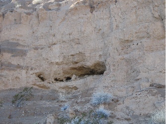 At the base of the cliff, I stopped to take a photo of the cave. It looked very promising. In fact, I was sure I could see signs of a manmade wall inside the cave.
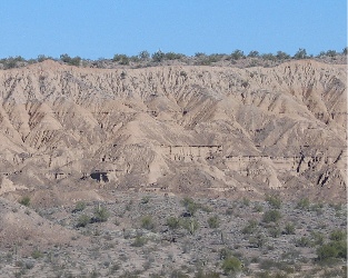 Disappointed, we made our way back down the hill. We stopped on a sunny spot and ate lunch, admiring the view across the wash, where years of erosion had eaten away the cliffs.
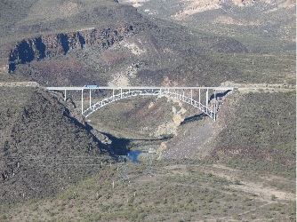 We followed the river east to route 93 and explored some of the rock formations there. Some people on ATVs looked up at us as we flew over. Then we headed up the road to Burro Creek. Mike wanted to see the campground from the air; we were thinking about spending a few days there at the end of the month. He shot these two excellent photos. The bridge over Burro Creek. (Yes, it is possible to fly under the bridge, but we didn’t do it that day. The bridge isn’t the problem; the power lines, which hang lower than the bridge, are what’s scary.)
 I wrote about my first landing at the Kofa Cafe in an article for wickenburg-az.com’s Day Trips section. I liked the restaurant’s big servings and down-to-earth atmosphere. I liked all the junk out on the front porch and in the yard. I liked eating with the truckers. I liked taking the helicopter someplace that wasn’t on an airport but didn’t get me in trouble. Three-Niner-Lima parked in the truck parking area the first time I visited the Kofa Cafe. The Cafe is the blue building.