Flying in a Heat Wave: Safe? Legal?

I explore the logic behind performance charts and what the FAA told me about flying in hot weather.
Upcoming Weather
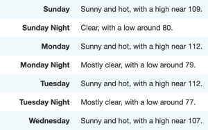
Next week’s weather. It’s going to be hot.

I have a Part 135 check ride coming up on Tuesday. Per the National Weather Service — my primary source of weather information — the forecast high in Wenatchee for that day is 112°F.

If you live in any country other than the metric-unfriendly US, that’s 44.4°C.
IGE Hover Chart
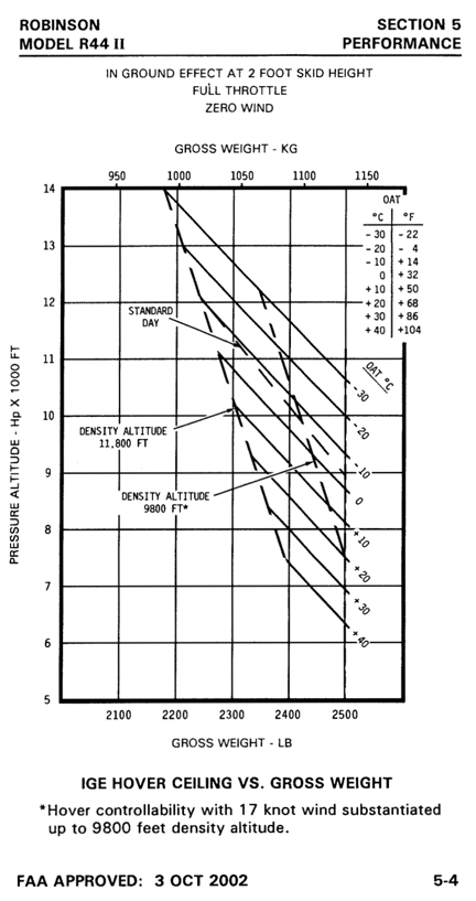
The IGE Hover Chart for an R44 Raven II does not chart any performance data for temperatures above 40°C.

The In Ground Effect (IGE) Hover charts for a Robinson R44 Raven II, which is what I fly, end at 40°C. That is, they do not provide any performance data for 44.4°C.

Now I learned to fly in Arizona and on a typical summer afternoon, 112°F was not uncommon. We flew in all kinds of heat. Hell, I remember landing at Bullhead City one day and reading 123°F on my outside air temperature (OAT) gauge. (And that was in a helicopter without air conditioning.) If the flight school I attended — which is still in business — didn’t fly when it was above 104°F (40°C), they wouldn’t be able to fly half the day about a third of the year. No one questioned whether it was safe or legal. We just did it.

Time went by. Someone suggested to me that flying when the temperature was above 40°C was not only unsafe but illegal. “You’re a test pilot when you do that,” more than a few people have told me. “Your insurance wouldn’t cover you in a crash,” another said, “because you’re operating outside of published data.”

Curious to see what other pilots thought about this, I put a poll on Twitter and gave the Pilots of Twitter 24 hours to respond. I also asked for comments. A lively discussion got going in the comments. It was also pointed out that I could have added “Unsafe but legal” as one of the options with the shared opinion that “the FAA gives you enough rope to hang yourself with.”

I do recall airplanes being grounded at Phoenix Sky Harbor airport one day when temperatures were “too hot” for some of the airliners, although it wasn’t clear from articles I read about how the limit was established.

Well, in an effort to head off a “gotcha” by my FAA examiner, I emailed him this morning to warn him of the heat:

A quick heads up.

We’re expecting high temperatures of 112°F on Tuesday. If you are of the school of thought that says we can’t fly when temperatures exceed 104°F because that’s the highest temperature on performance charts, we should probably plan to fly very early, before the temperature tops out. …

If you’re not of that school of thought — I learned to fly in Arizona so I’m not — we should be fine. The helicopter does have air conditioning, although I’ve never tested it in 112°F weather.

Please let me know what time you plan to arrive.

He replied, in part:

I am unaware of a temperature limitation that restricts operations of the R-44. We can complete the ground during the afternoon of the 28th so we can fly on the morning of the 29th to minimize the effects of the heat. …

So that’s telling me that it’s legal. (But he’s not taking any chances or doesn’t want to test my air conditioning.)
Never Exceed Speed
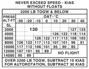
Here’s a limitations chart: Never Exceed Speed. If I extrapolated, I think operations at lower elevations would be fine, but I certainly wouldn’t exceed about 85 knots 44°C at 8000 feet. (Heck, the helicopter would be vibrating like crazy at that speed and elevation anyway.)

Is it safe? Well, as this “test pilot” could tell you, if you extrapolate the data in the charts, keeping in mind the aircraft’s gross weight and the altitude you would be operating at, it can be. Keep the aircraft light, don’t plan any high altitude landings, and keep your speed down.

Chances are, the helicopter will continue to operate in heat that you won’t want to be flying in anyway.

Morning Helicopter Flight to Quincy

Another video from the Flying M Air YouTube channel.

I was unexpectedly called out to do a cherry drying flight on Saturday morning. Here’s footage from the nose cam with narration added in production.

More Info:

Note: This is the 1080 FHD version of this video. There is an ad-free 4K version of this video for top-tier channel members That’s my thanks for their financial support to this channel. Become a channel member at the Access Premium Content level to watch 4K versions of channel videos.

Playing the Weather Game

Why I check the weather multiple times a day every day all summer long.

My main business — my bread and butter and steak and potatoes — is using my helicopter to dry cherries. I’ve written about this numerous places and even have YouTube videos about it, so I’m not going to go into detail here. You can find some of my blog posts about it by clicking the cherry drying tag.

Being a serious cherry drying pilot means watching the weather incessantly so you can be close to the helicopter when called out to fly. I watch the weather three ways:

  • National Weather Service Forecast. I don’t care what anyone says about their favorite source of weather information. In the U.S., all weather data comes from NOAA and is made available on the NWS website. That’s Weather.GOV, not Weather.COM. I have point forecasts set up for the three areas that interest me most: Malaga, Quincy, and Mattawa. I have bookmarks set up for all three on my laptop computer, desktop computer, iPhone, and iPad. Throughout the day, I consult them numerous times. When there’s rain forecasted for the near future, I also look at the hourly forecast to see what time of day the rain might come.

    Weather for this Week
    The forecast icons make it easy to see the weather at a glance.

  • Radar Image
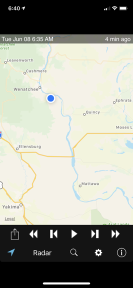
    Of course, there’s nothing on radar now, but if there was, this image would be full of gray, green, yellow, orange, or even red shading to show storm severity.

    Weather Radar. Again, I use a NOAA product to check the radar for the area. In this case, it’s the RadarUS app on my iPhone or iPad. When there’s rain in the area, I want to know where it is, how heavy it is, and which way it’s moving. This app can give me all of that information. I can even zoom in with a satellite image overlay to see how close it’s coming to the orchards I’m under contract to cover.

  • Sky watching. Wherever I am — although I’m usually at home this time of year — I watch the sky. Are there clouds? Do they look threatening? Is rain falling from them? What does that look like on radar? Which way are they moving? While I can’t see the Quincy or Mattawa areas from here — and they do both have different weather than we do locally — I can get a good idea of what’s going on in my immediate area where I have the most acreage to cover. I can also often see large storm cells over the Waterville Plateau that might be headed for Quincy.

    Sky Watching from Home
    This is the view from my house. I have a mostly unobstructed view from the southwest to the northeast so I can literally see the weather coming — unless it’s coming from the south. The view in this shot is looking mostly northwest.

The crazy thing is that the short term forecast changes every day. For example, last night, when I went to bed, the forecast showed a 20% chance of rain after 11 AM today (Tuesday). But this morning, as you can see in the above forecast image, that rain prediction is completely gone.

But it can just as easily come back.

Or rain without rain being in the forecast.

That’s what I call the Weather Game. You do everything you can to stay on top of the weather and the forecast is neither consistent nor reliable. I sometimes wonder why I bother.

In any case, this is part of my life until August when I’m done with cherry drying season. And even then, it’s hard to turn off the habit of checking the weather so often — I’m usually checking it regularly well into September.

Winter Helicopter Flight to McMinnville Part 2

Another video from the Flying M Air YouTube channel.

Here’s the second part of my March 2021 flight to McMinnville, starting west of Ellensburg, WA and running to the Yakima Reservation. This flight has both nosecam and instrument cam views, as well as cockpit narration and radio chatter. I’ll release additional parts of this flight throughout the summer.

Note: This is the 1080 HD version of this video. A ad-free 4K UHD version without the animated subscribe button is available to MEMBERS at the Access Premium Content level. That’s my thanks for their financial support to this channel.

Helicopter Flight Over Wenatchee

Another video from the Flying M Air YouTube channel.

Join me for a 20-minute flight from the maintenance hangar at Wenatchee Pangborn Memorial Airport to the Columbia River, up to the Rocky Reach Dam, and back down to Malaga. Along the way, I’ll tell you about what you’re seeing and tell you about my helicopter maintenance and ground handling wheels.

Note: This is the 1080 HD version of this video. A 4K UHD version without the animated subscribe button and Member Wall that also includes landing at my summer base is available to members at the Sponsor level or higher.