I return for a weekend-long rides gig.
Last year, I wrote extensively about the Big Sandy Shoot, an event held north of Wikieup, AZ by MG Shooters, Inc. I’d gone to the event at the urging of my friend Ryan, and although I did some helicopter rides, it wasn’t a terribly good gig for me. But it certainly was a fascinating experience.
A few months ago, the MG Shooters folks contacted me, asking me to come to this spring’s shoot. The rich guy with the helicopter who’d shown up last year and had given free rides had sold his helicopter. I wouldn’t have to compete with him. I checked my calendar, saw that Mike and I had the weekend free, and decided we’d try again. I didn’t expect to do many rides, but I thought it would be a nice opportunity to test out our camper in a real off-the-grid situation. We’d leave Jack the Dog and Alex the Bird at home with a house-sitter and just get away for a weekend. If I did rides, great. If not, I’d brought along a book to read and Mike could study for his helicopter check ride, which is later this week.
Getting There
The weather was bad on Thursday and Friday, with heavy rain throughout most of the day. This was good and bad. Good because the shooters would be able to use tracer rounds during the night shoots without worrying much about starting fires out in the otherwise dry desert. Bad because the shoot location is about 5 miles from pavement on the other side of the Big Sandy River. The Big Sandy River does not have a bridge at the crossing, so you have to drive across the river in whatever water is flowing. And the dirt roads often get a top layer the consistency of snot when they get wet.
Of course, I didn’t have to deal with this. I was flying in. What I had to deal with was the weather itself: clouds, rain, wind, etc. We waited until [too] late in the day to make our go decision. Mike pulled out with the camper in tow at about 5 PM and I went to the airport.
In Wickenburg, the sky was partly cloudy and the winds were no more than breezes. I’d checked the weather along the route 93 corridor where I’d be flying, all the way up to Wikieup and Kingman. It didn’t seem bad, but it certainly didn’t seem good. As any pilot who flies in remote areas can tell you, weather forecasting isn’t exactly perfect for areas where there aren’t any airports or cities. So although my destination was 60 miles from Wickenburg, I couldn’t get any solid weather information for it. I had to extrapolate based on what I was experiencing in Wickenburg and what was going on in Kingman, another 30 miles northwest of Wikieup. The radar images helped. And just looking out the window in the direction I had to fly helped.
The plan was for me to fly up there and scout out the river situation from the air. If the river was flowing too swiftly to drive across, I’d call Mike on the aviation radio he had with him and tell him. We’d set up camp at the Burro Creek campground about 30 miles south on route 93 for the night. I wasn’t sure how they’d feel about a helicopter landing down there, but was willing to find out if I had to. (Obviously, I wouldn’t land in the campground itself.)
Because a straight-line route would have put me in the mountains east of route 93, I decided to follow route 93 itself. (IFR: I follow roads.) There were two benefits for that. First, if weather closed in, I could land near a paved road where I could meet up with Mike or get a ride with someone else if I had to. Second, I could check out Burro Creek campground from the air to make sure there were potential landing zones and open camping spaces.
It was an uneventful flight. The winds were not much more than light breezes. Although there were a significant number of clouds at my altitude, none of them were near my flight path. Instead, they obscured the mountain tops on either side of the valleys I flew up. I never got within a mile or two of any of them.
I passed Burro Creek and saw that the campground was about 80% full. I also noted that they’d never painted the second bridge over the canyon there. (I’d taken a photographer from Utah to shoot the bridges from the air as the second one was being completed at least a year before.) I climbed over the mountains there and dropped down into the valley where the Big Sandy River flowed. It wasn’t flowing much at all. In some places, the riverbed was dry, in other places, there was about a foot of water flowing. It was a lot like the Hassayampa River, which flows mostly underground through Wickenburg. I overflew Wikieup, then concentrated on my GPS to locate the shoot site.
It was a good thing I had the waypoint programmed into my GPS. The shoot was quite a bit farther north and east than I remembered. It was in the foothills of the Aquarius Mountains. A line of clouds at my altitude hid the mountaintops from view. The shoot site was about 1/2 mile from the clouds. A bunch of people were set up on the flattened out ridge top with campers and shade structures.
Now, I’d been told that they’d put in two helipads since the previous year. And try as I might, I just couldn’t find them. I circled once, coming quite close to that cloud bank, then decided to land, shut down, and get directions from the ground. I used my cell phone to call Mike and leave him a message about the river conditions — I knew he was too far out for the radio — then landed on the southwest edge of the ridge.
 Turns out that the helipads were nothing more than just flattened out areas on the north side of the ridge. Someone had decided that the closer helipad would make a great campsite and had set up a ton of camping gear on it. Ed, the guy who runs the place, suggested that he move, but the guy camped out there wasn’t interested in that. He tried to say that it was muddier there than anywhere else. That simply wasn’t true, although the mud leading up to that spot was terrible. So Ed and I found another place on the east side of the ridge. It was higher and dryer and although it hadn’t been cleared for helicopter use, I had no trouble landing there. Best of all, it was closer to where the shooters and spectators would be hanging out, so I was more likely to get people coming over to me.
With the helicopter settled in and the light fading quickly, my thoughts turned to Mike. Last year, he’d gotten lost on his way in from route 93. I didn’t want him getting lost in the dark. So I found someone with a truck who was willing to take me down to the main road and guide him in. That’s when I saw how muddy the road was. It was almost frightening — especially one steep hill covered in reddish brown snotty mud.
We literally almost ran into Mike. He didn’t know I was in the truck, so he didn’t stop. My driver, Ron (I think), made a U-turn and tried to catch up with him. We were more than halfway back when Mike finally stopped and I switched vehicles. We followed Ron the rest of the way up, checked in at the registration area, then climbed to the ridge and parked the camper near the helicopter.
Night Shoot
We were just finishing the camper setup — which included parking its right wheels on five leveling blocks and using large stones to prevent it from rolling away — when the night shoot began.
 If you’ve never been to a machine gun shoot, you’re missing a really outrageous event. These guys have the same kinds of guns the military has/had for warfare and I think they have more ammo than the military issues to its soldiers. And they’re not afraid to shoot it. At night they use tracer rounds that clearly show the path of the bullets as streaks of red or green light. The sound of fire is deafening and every once in a while, it would be punctuated by the loud boom of a reactive target (i.e., stick of dynamite) going off.
At 10 PM, the shooting stopped. By that time, Mike and I were already in the camper, getting ready for bed. It started raining lightly outside. It got quiet and we slept pretty well.
The Big Day
In the morning, the low clouds were back, but never really drifted into our area. The big camp slowly came to life as shooters woke. The local 4H club was serving breakfast and the bacon smelled excellent. After breakfast in the camper, I went out with some rags to dry the dew off my helicopter. We hung a sign that said, “Helicopter Rides $35” on the back of the camper, which faced the rest of the camp. At 8 AM, I had my first passengers.
I flew much of the day. It wasn’t nonstop, but it wasn’t stop-and-go, either. Generally, I’d get three or four flights in between shutdowns. Then I’d get out and grab something to drink or take a pee or do something in the camper before the next few passengers showed up. Most flights had just two people on board — most of these guys were pretty “healthy” — and I made the flights a bit longer than I needed to. The later flights were a bit shorter — after all, I wanted to make money on this event — and included a view of the little waterfall in the foothills about a mile east of the camp.
 Meanwhile, the shooters were shooting. They started up at about 9:30 AM and stopped at noon for lunch. Then 1:00 PM to 5:00 PM when they stopped for dinner. They kicked off the 1 PM shoot with the detonation of a pig statue packed with explosives. I was in the air when they did it, but my passengers and I saw the smoke out in the target area. Mike said that the car alarms for all the cars and trucks had gone off.
We used our new fuel transfer tank to refuel the helicopter. It didn’t work quite as expected. Mike got tired of cranking after about 2/3 of the fuel had been pumped and made the fatal error of stopping. The fuel drained out of the hose and we couldn’t get the damn pump primed again. So the remaining 1/3 tank (about 8 gallons) remained in the transfer tank. Later, I made a fuel run to Kingman which took about 5 minutes longer than it needed to when I parked the helicopter about 3 feet farther away from the pumps than the hose would reach and had to start up to move it. (I hate when that happens.)
The weather threatened rain to the east and west of the site most of the day. On a few flights into the mountains on the east, I got drizzled on. We saw rainbows, too. But the clouds broke up around sunset. I stopped flying at 6 PM after taking at least 40 people for rides.
We made dinner in the camper and opened a bottle of wine. Outside, everyone was preparing for the night shoot. It got dark and people started shooting off flares. They’d shoot into the air like a fireworks rocket, then explode. A red light would glide to earth at the end of a small parachute, lighting up the range. Occasionally, one would land before it went out, setting a small bush on fire. But the earth was so wet that the fire soon went out.
The night shoot began loudly. Mike and I walked down the back of the firing line, past the shooters, taking photos and videos as we went. Thank heaven for ear plugs.
The Last Day
By morning, the folks who hadn’t left the night before were packing up to leave. There was another shoot scheduled, but only the hard-core shooters seemed interested. I flew another 10 or so passengers. The waterfall was drier and harder to spot in the canyon. Between flights, Mike and I packed up the camper.
I was on the ground when one of the shooters, a man who had made a canon out of a fire extinguisher, shot a red bowling ball over the range. That thing climbed at least 300 feet, with the wind whistling through its finger holes, before crashing to earth. He’d been shooting the bowling balls all weekend, but I always seemed to miss them. Seeing it was a treat.
Mike and I had lunch, hooked up the camper, and prepared to leave. I took Mike on a quick flight up in the mountains before dropping him off at the landing zone. I flew home the direct route, detouring only to peek into Bagdad Mine on my way back. Total flight time for the weekend: 6.2 hours. When I later tallied up the money, I discovered that I did a little better than breaking even. (Should have made the rides a little shorter.) But it was enough to come back.

 Turns out that the helipads were nothing more than just flattened out areas on the north side of the ridge. Someone had decided that the closer helipad would make a great campsite and had set up a ton of camping gear on it. Ed, the guy who runs the place, suggested that he move, but the guy camped out there wasn’t interested in that. He tried to say that it was muddier there than anywhere else. That simply wasn’t true, although the mud leading up to that spot was terrible. So Ed and I found another place on the east side of the ridge. It was higher and dryer and although it hadn’t been cleared for helicopter use, I had no trouble landing there. Best of all, it was closer to where the shooters and spectators would be hanging out, so I was more likely to get people coming over to me.
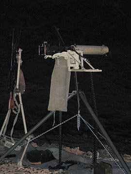 If you’ve never been to a machine gun shoot, you’re missing a really outrageous event. These guys have the same kinds of guns the military has/had for warfare and I think they have more ammo than the military issues to its soldiers. And they’re not afraid to shoot it. At night they use tracer rounds that clearly show the path of the bullets as streaks of red or green light. The sound of fire is deafening and every once in a while, it would be punctuated by the loud boom of a reactive target (i.e., stick of dynamite) going off.
 Meanwhile, the shooters were shooting. They started up at about 9:30 AM and stopped at noon for lunch. Then 1:00 PM to 5:00 PM when they stopped for dinner. They kicked off the 1 PM shoot with the detonation of a pig statue packed with explosives. I was in the air when they did it, but my passengers and I saw the smoke out in the target area. Mike said that the car alarms for all the cars and trucks had gone off.