About Helicopter Fuel Consumption

It’s only part of the cost of operations.

Among the stats recorded for this blog are the search phrases people use to find content here. I can’t tell you how many times I’ve found search phrases related to “helicopter mileage” or “helicopter miles per gallon” or “helicopter fuel burn.” It seems that a lot of people are really interested in learning how much fuel a helicopter burns.

It’s not just the blog, either. I get related questions every time I do a rides gig. I’d say that 1 out of every 10 adult passengers wants to know how many miles per gallon my helicopter gets or gallons per hour my helicopter burns.

Of course, a helicopter’s fuel burn varies based on its make and model — just like an SUV will burn more fuel than a compact car. Bigger engines burn more fuel.

Fuel burn also varies based on conditions, again just like a car. If I cruise alone on a cool day near sea level, the helicopter will be operating efficiently with a light weight to carry and burn less fuel than if I operate near maximum gross weight on a hot day. This is similar to a car’s “highway” and “city” MPG ratings.

Ready for my answer to the question?

My helicopter burns roughly 15 to 17 gallons per hour, depending on conditions.

Helicopters generally take one of two different kinds of fuel. Some helicopters with piston engines, including mine, burn AvGas, which is also known as 100LL, a high-octane, leaded fuel similar to what you might put in a car. (I actually “dispose of” spoiled AvGas in my lawnmower and ATV once in a while. My understanding is that the lead will damage a car’s catalytic converter so I’d never put AvGas in my Jeep or Honda.) Other helicopters with turbine engines, like a JetRanger, burn JetA, which is the same stuff they put in jet airplanes. (It’s also remarkably similar to diesel, although I’ve never put JetA in my truck.)

Aviation fuel prices vary the same way auto fuel prices vary. AvGas and JetA seldom cost the same. These days, my local airport sells AvGas for $5.14/gallon and JetA for $4.04/gallon. The least I’ve ever paid for AvGas was $2.43/gallon way back when I first started flying. The most was around $9/gallon when I needed to refuel at an airport with a fancy FBO that normally caters to business jets. Ouch.
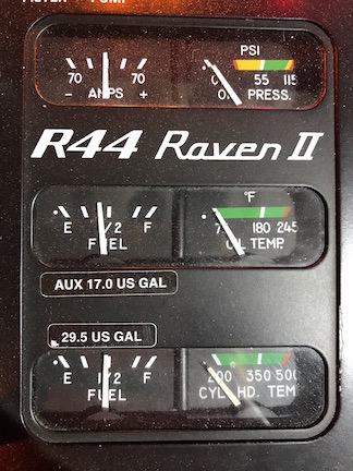
R44 Gauges
I have two tanks that supply the engine with fuel from a single feed (so there’s no need to switch tanks in flight) for a total of 46.5 gallons of usable fuel. (The Master switch is on but the engine is not running in this photo.)

My helicopter can hold about 46 gallons of fuel. I can fly for 2-1/2 to 3 hours on that, depending on conditions. If you figure I average about 100 knots when cruising — that’s 115 miles per hour or 185 kilometers per hour — I can cover about 300 miles on a full tank. Of course, that also depends on wind conditions; I’ll fly fewer miles with a headwind than with a tailwind or no wind.

One more thing. The reason most people seem interested in learning about fuel consumption is because they’re trying to figure out what it costs to fly a helicopter. (At rides gigs, they’re usually trying to figure out my profit.) What they fail to understand is that fuel is only a small part of what it costs to fly. I’ve blogged about this extensively here. Fuel currently accounts for less than a third of my operating costs.

So you can imagine how annoyed I get when people offer to just “pay for fuel” if I fly them somewhere. As if I’m interested in picking up two thirds of the cost of giving them a ride and throwing in my time for free, while forgoing any possibility of a “profit” to help cover the cost of operating my business.

(And what about the $14,000 I need to spend later this year to install a radio altimeter that I’ll never need?)

Anyway, I’m hoping that this post comes up in those searches now. It answers the question succinctly in a way that most people can’t fail to understand.
Freedom Day Comes and Goes without Notice

If I didn’t have it on my calendar, I’d likely forget its significance entirely.

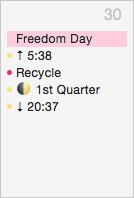
Freedom Day
You can see how I missed it; it’s just a tiny note on the calendar.

It was Tuesday, July 30, 2013 that my very favorable divorce decision came through. Although I thought at the time that it would be the end of the bullshit my wasband was sending my way during our crazy divorce, it was just the beginning of a new chapter. Some people are seriously delusional and make all kinds of bad decisions based on their delusions. My wasband is a textbook case of this for the period starting around January 1, 2012 through (likely) today.

I called it Freedom Day because I was finally free of sad sack old man who was holding me back from moving forward with life. I didn’t realize how much I’d been held back until I was free to make my own decisions without having to compromise or, worse yet, wait for a risk-adverse “partner” to provide input. In the four years since, I not only bought the land for my new home — which I did the very next day — but built a custom home to my specifications on it, doing much of the interior work myself. I’ve tripled the amount of contract work I do each year, building my flying business far beyond I ever thought I could. I’ve met new people, made new friends, and traveled to new places.

In short: I’ve accomplished far more in the past four years than I had in the previous 10.

I’ve since settled into the kind of laid back and flexible lifestyle I always imagined having in my later years of life, free to do what I want with my time. I’m living life on my terms and if that isn’t freedom, what is?

Freedom Day is on my calendar as a recurring annual event. I put it there back in 2013 because I was so happy to finally have my poisonous relationship behind me. But unlike other people who hold significant dates close — often too close — to their hearts and minds, my Freedom Day is little more than that calendar reminder. This year it came and went without me even noticing it.

And I think that speaks volumes about where I am in my life today.

Another No Fly Decision

Smoke in the area forces me to cancel a scenic flight.

I’ll start this one with a story.

Flashback: Grand Canyon 2004

When I flew for Papillon at the Grand Canyon, Mother Nature threw all kinds of weather at us. In the spring, it was wind, sometimes blowing as hard as 50 miles per hour, causing all kinds of mechanical turbulence on our prescribed tour routes over the forest and Canyon. In the early summer, it was heat and high density altitude, which made the departure and arrival in our rather confined landing zone challenging. Then there were the fast-moving monsoon storms that sped across the terrain, sometimes blocking our path across the canyon and forcing us to shut down when lightning near the airport made it unsafe to refuel. (And yes, we did fly within 20 miles of thunderstorms.) That lightning would often start fires in the forest along the Grand Canyon’s rims, filling the air with thick smoke that made it nearly impossible to see.

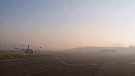
Special VFR at GCN
Here’s an early morning view on one of those smokey days at the Canyon. The R22 on the left is mine, parked at transient helicopter parking at Grand Canyon Airport. I used to commute to work by helicopter once in a while; I needed a special VFR clearance to get into the Class D airspace that day. The tall building in the haze is Papillon’s base with its tower.

Honestly: flying at the Grand Canyon is the best experience a helicopter pilot can get. There isn’t much that you don’t experience as far as flying conditions go.

On one late afternoon in August, the area was full of storms and smoke from numerous wildfires. I took off in trail behind at least six other helicopters with another four behind me for one of the short tours. The passengers had come off a bus and their tour had likely been booked years in advance. All 11 helicopters were flying with the same group.

When we reached the Dragon Corridor, where we were supposed to cross the Canyon, we found our way blocked by a thunderstorm that made it impossible to see the other side of the canyon. So one by one we made our radio calls, turned around, went back past the airport, and crossed over the Canyon in the Zuni Corridor. There was a short tour on that side that we’d been taught but Papillon didn’t sell. I’d never flown it, so I basically followed the helicopter in front of me, making the same calls he did when I reached vaguely recalled reporting points.

The air was thick with smoke. The visibility was definitely less than five miles, although it had to be more than three miles for flight to be legal. But maybe that’s what it was at the airport. It wasn’t that over the canyon. At one point, I lost sight of the strobe light of the helicopter in front of me and had to find my way back without him. (We did not have GPSs on board.) I only got a little lost and was very glad to finally see Grand Canyon Airport’s tower. I adjusted my course to put me where I was supposed to be, made my radio call, and landed.

They shut down flights for the day after that.

Afterwards, I went up to the Chief Pilot’s office. His name was Chuck and he’d always struck me as someone who was very reasonable. I complained about the visibility and asked him why we were taking people on scenic flights when we could barely see. His response stuck with me: “If they’re willing to pay and it’s safe to fly, we’ll fly them.”

I swore I’d never take that attitude with passengers in my tour business. Indeed, years later I turned down a flight I could have done because I was certain that wind and turbulence would have made my passengers miserable.

And I’ve turned down flight since. Today is one of those days.

Today: Smoke in the Wenatchee Valley

The hour-long tour for one of my client’s vice presidents and his out-of-town guests has been on my calendar for about two months. I have the passengers names and weights and have done my weight and balance calculations. I know where they want to go and what they want to see.

The smoke started blowing in last week, which is kind of weird because (1) there aren’t any fires nearby and (2) there isn’t much wind. Apparently the fires are mostly in British Columbia (Canada), which isn’t very far from here, was well as in northwestern Washington State, on the other side of the Cascades. There was a rumor going around that there’s a fire in Blewett Pass, which is actually quite close, but I can’t find any information anywhere about that, and I have good sources to check.

Smoke from the Airliner
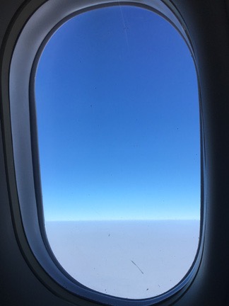
As this photo from my friend shows, the smoke was a thick blanket up to about 14,000-18,000 feet.

So the smoke is drifting down from Canada on a light breeze. It’s settling in the Columbia River Valley at Wenatchee. And elsewhere. A friend who who took a Horizon Airlines flight out on Thursday sent a picture from 20,000 feet and there was a blanket of smoke right beneath the plane. It was so bad I blogged about it.

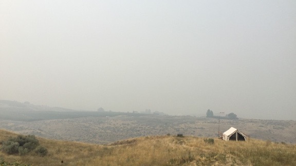
For the first few days, it was a light haze. But yesterday it settled in so thick that not only could I smell the smoke, but I couldn’t see the river from my house, let alone the airport on the shelf right above it. Sure enough, the airport was reporting 1-1/4 mile visibility. Instrument meteorological conditions (IMC), meaning that it wasn’t legal for me to fly without getting a special VFR clearance from Seattle.

Bad View
I shot this photo from my deck yesterday when the visibility was at its worse.

Foreflight Weather
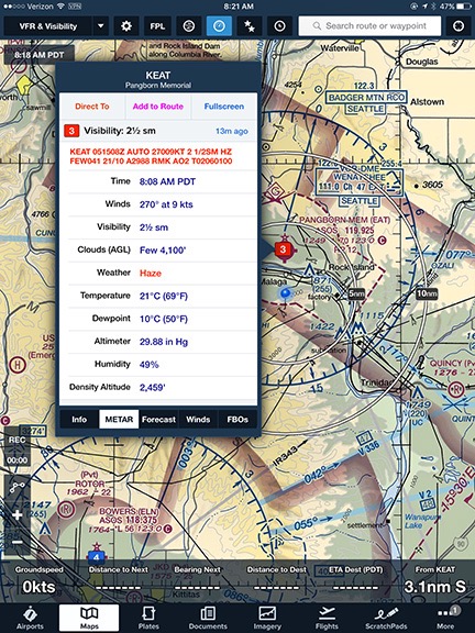
Turning on ForeFlight’s visibility layer displays visibility in miles at each airport that provides this data. Clicking the number displays details.

I emailed my client yesterday, asking him to check in with me an hour before the flight. But I wound up calling him this morning, two hours before the flight. I’d used ForeFlight, the basis of my electronic flight bag, to check conditions at Pangborn Memorial Airport, which I could barely see across the river. It was reporting visibility at 2-1/2 miles: IMC.

Could I fly in these conditions? Technically, yes. I could get a Special VFR clearance to leave my home (which is within Pangborn’s Class E airspace) and fly up to Baker Flats where my client would be waiting. That’s in Class G airspace where only 1/2 mile visibility is required for helicopters during the day. I could then do the whole tour, making sure I stayed out of class E airspace or get another clearance if I wanted to enter Class E. So yes, it’s legal.

But is it safe? Well, since I would always remain within sight of the ground and whatever’s at least a half mile in from of me and I can fly at virtually any speed to keep it safe, then yes, it’s safe.

So by Papillon’s standards — at least those back in 2004 when I flew there — I shouldn’t hesitate to do the flight. After all, it’s money in the bank, right?

I don’t think that way. It’s all about passenger experience. Other than me getting paid for a hour of flight time, what’s the benefit? The tour would be terrible — my passengers wouldn’t be able to see more than a mile or two during the entire flight. What’s “scenic” about that?

My client understood perfectly. He was happy to cancel. We agreed that we’d keep an eye on conditions and that if, by some miracle, a wind kicked up and blew some of the smoke out, we could try in the afternoon. Or maybe tomorrow. I’ve got nothing on my schedule. But it’s more likely that we won’t do it at all since his guests are leaving town on the 6 AM flight tomorrow morning. (Provided Horizon can get the last flight in tonight.)

In the meantime, I don’t mind staying home today. It’s better indoors with the windows shut than outside breathing that crap we’re importing from Canada.

Mango (or Cherry) Salsa

A nice Whole-30 compliant accompaniment for grilled meats or fish.

As I blogged the other day, I started the Whole30 Challenge on Monday. Part of the challenge — in my mind anyway — is preparing interesting foods that distract you from the fact that you’re missing out on favorites like dairy and whole grains.

A friend came over the other night with a nice piece of salmon. I fired up the Traeger, placed the seasoned salmon on a cedar plank, and cooked it outside while we chatted. I’d already prepared some mango salsa to go with it, following a recipe I’d found on the Traeger website. But that recipe called for honey or agave sweetener, which is verboten on Whole30. So I simply omitted it.

Here’s the recipe as I made it:

  • 1 cup mango, diced. I keep frozen mango in my freezer for smoothies and that’s what I used. It’s quick and easy to incorporate into recipes, including my mango chutney.
  • 1/4 onion, finely chopped. The original recipe called for a red onion and I didn’t have one.
  • 1 small jalapeño pepper, minced. The original recipe called for habanero pepper, which I believe is hotter, but I used what I had on hand.
  • Juice of 2 limes. In hindsight, I think I could have done it with just one lime.
  • 1/4 cup fresh cilantro, chopped.

Combine all ingredients. Cover and store in refrigerator until ready to use.

This was excellent on the salmon. It was also good with my egg and onion scramble this morning for breakfast.

Cherry Salsa
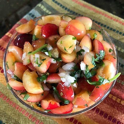
Cherry salsa made with fresh-picked rainier cherries. What could be better with a summer meal?

On Wednesday, I went cherry picking with a friend and brought home about 10 pounds (or more?) of Rainier cherries. The owner of the orchard where I pick often makes cherry salsa. I realized that her recipe was likely very much like the one above, but with cherries instead of mangos. So I made a batch. I’ll eat it with some grilled pork chops for dinner tonight. Yum.

Where There’s Smoke…

…well, there are no fires here.

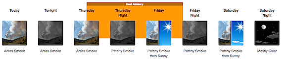
When you live out west, the weather forecast can include information related to smoke. And that’s the situation this week, for good reason:

Forecast
This is not the kind of forecast I like to see.

The smoke drifted in yesterday morning, looking like a low thin cloud layer. Throughout the day, it thickened and settled into the valley I can see from my house.

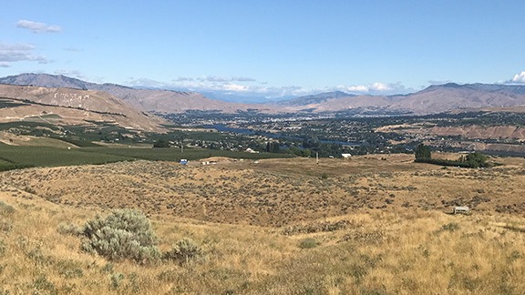
Normal View
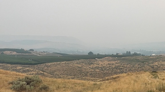
Smokey View
My normal view (top) includes glimpses of the North Cascades, at least 50 miles away. Add wildfire smoke and you get my view this morning (bottom), which is barely four miles.

As the northwest’s weather guru, Cliff Mass, blogged yesterday, the smoke is mostly from fires in British Columbia, which isn’t too far from here. There are two fires in northwestern Washington and I heard a rumor that there was one much closer at Blewett Pass, but have not been able to confirm that. Fortunately, they’re not here — although there’s plenty ready to burn if a spark or ember touched down.

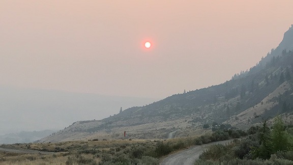
Sunrises and sunsets have been minor events lately, with the sun looking like a Sunkist navel orange as it hovers on the horizon. It reminds me of the sunsets back in New York that I admired so much. I remember the one on July 10, 1983 that I drove down to the West End 2 parking lot at Jones Beach to photograph. An orange ball like the one in the sky here today sunk into the western horizon, silhouetting Manhattan skyscrapers in the distance. I got more than photos that day, but that’s a story not worth telling anymore.

Smokey Sunrise, Untouched
Here’s what the sun looked like about 1/2 hour after sunrise. This is an unedited (except for cropping) cell phone photo.

Oddly, back in those days I never realized that that orange ball sunset was caused by air pollution. Ick.

I was supposed to make a day trip by helicopter to visit a friend of mine out on Lopez Island today. It’s an 80-minute flight and I can land in my friend’s yard. I haven’t seen him in months and was really looking forward to it. But when I checked the weather this morning and discovered that the smoke was moving out his way, too, I had second thoughts. My email to him at 6 AM asking whether there was smoke and his response confirming there was was enough for me to change my plans and stay home. If it’s smokey here and smokey there then it’s likely to be smokey en route. And the last thing I wanted to do today was spend nearly 3 hours in a helicopter flying through smoke. (The journey is usually almost as good as what awaited at the destination.)

So I’m home for the day. I went out this morning to pick blueberries and glean rainier cherries with a friend. But we were back by 11. It’s hot and sticky out in the filtered sunlight, with a level of humidity I like to avoid. I’ll do some work in my garage with my new jumbo fan pointed at me. When I get tired of that, I’ll come back upstairs, take a shower, have a snack, and do things in air conditioned comfort.

Or take a nap.

But you can bet I won’t be outside, breathing the dirty air sent down from Canada.