We “walk inside a mountain” near Flagstaff.
We spent Memorial Day weekend — or what was left of it after my Biltmore Apple Store gig — at our place on Howard Mesa. We bought 40 acres up there, fenced it in a few years ago, and added a septic system two years ago. This year, we’re adding a small, one-room cabin.
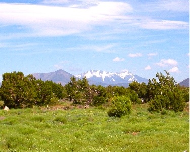 Howard Mesa was beautiful. Or maybe I should say that it was more beautiful than usual. The grass was knee-high and green and the seed tops swayed with the wind. The San Francisco Peaks were still snow-covered, off in the distance. Best of all, we seemed to have the whole place to ourselves — as usual.
We spent Sunday doing odd jobs and relaxing around the camper. We went out for dinner that night in a restaurant in Parks, about 35 miles from our place. The place, called Rack and Bull, had probably been set up as a moderate-to-high priced dining experience that featured wild game, lamb, and ribs. It had since succumbed to the need to attract a wider range of clientele. The menu wasn’t anything special and they offered pizza. But the decor was very nice, the service was excellent, the food was good, and the value for the dollar was right on target. Why can’t we have a few places like that in Wickenburg? Heck, Parks must have a fraction of the population. But let’s not go there.
On Sunday, after a nice long walk, we decided to hop in the truck and take 180 toward Flagstaff. The idea was to take the aerial tram at the Snowbowl to the top of the peak. But I had a booklet called 99 Things to Do in Northern Arizona and it suggested a few more interesting things (as well as many far less interesting things). The one I was thinking about was headed “Walk Into a Mountain.” It appeared that northwest of Flag was a mountain that had collapsed long ago, forming a natural amphitheater filled with interesting rock formations, trees, and not much else. The booklet compared its formations to the hoodoos at Bryce Canyon. Sounded interesting to me.
We saw the place on the right side of the road before we saw the promised signs for it. I’ve been up and down that road over 20 times and various times of the day and night and I can’t recall ever seeing that mountain. But there it was, red mountain, looking exactly as the description promised.
We pulled into a parking lot that had about six other vehicles in it. Jack the dog was with us, but there weren’t any NO DOGS or DOGS ON LEASH signs, so I stuck his leash in my pocket and let him run loose. He’s very well behaved on the trail — better than Spot ever was — and he absolutely loves hiking with us. He runs ahead, chases rabbits, then comes tearing back to us, only to take off in another direction. He probably runs four times the distrance we walk, but that’s okay. He’s younger and in better shape. Mike took a bottle of water, which he hung on his belt loop with a bungee cord. (How’s that for high-tech hiking equipment?) Then we started the 1-1/2 mile hike to the opening in the mountain.
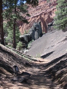 The trail, which was wide enough for hikers, bikers (the pedal kind, that is), or horseback riders, was smooth and covered with crushed red cinders. In places, it was heavily eroded, but not enough to make walking a problem. That was a good thing, because I hadn’t brought hiking shoes. I was wearing my red Keds and that’s probably the only kind of surface I could have walked 3 miles on. The trail climbed gently most of the way. It wound through the trees, then dropped into a smooth-bottomed wash and climbed toward the mountain in that. Soon, we were in a canyon with slopes of dark grey volcanic gravel on either side of us. It was fine stuff, like the red cinders we walked on. There were a few interesting formations right at the mountain’s entrance. Beyond them, we could see the red hoodoos inside the mountain.
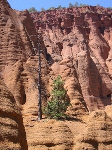 It appears to me that Red Mountain had once been a plain old mountain. Volcanic activity on one side had caused black lava to spew out of the ground. This undermined the mountain, causing a slide that took out about 1/3 of the mountain side. The result was the amphitheater the booklet told us about. Of course, this is all conjecture based on what it looked like. There was no interpretive sign in the parking area or elsewhere and no ranger to explain what we were seeing. I could have it completely wrong.
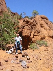 There are two ways into the mountain, both of which were described in the book. At the head of the wash we’d been following, someone had built a neat rock dam. A ladder climbed the six or eight feet up to the top of the dam where silt had backed up, raising the ground to the top of the dam. That’s how we went. Jack took the ladder like a champ. The other way was to climb up over a gray cinders covered slope. That’s probably the only way you could get in with a horse. (I know my horse doesn’t climb ladders.) Our way was easier. Inside the mountain’s amphitheater was exactly as the booklet had described. Lots of rock formations made of red sandstone carved by wind and water, with a bunch of dark gray formations just to make things interesting. We walked up to the head of the canyon, passing a family having lunch with their dogs. One dog, a Corgi, came yapping out after us, followed by a dog that looked like a mix of every dog breed in the world. Jack had some sniffing with them, then followed us.
We rested in the shade for a while, taking in the view. I took a few photos. The sun was high and the light was harsh. But it certainly did remind me of Bryce Canyon. After exploring the area for a while, we headed back out the way we’d come. Jack was unbelievable on the ladder, taking it just like one of the Lassie actors. The return hike seemed longer, but it was almost all downhill. There was enough shade to make it a comfortable walk, even in jeans and a long-sleeved shirt. Back in Wickenburg, it was in the 90s; up in the mountains near Flag, it was in the 70s. It was the same, strong sun — some people argue that it’s stronger at altitude because you’re closer to it (I can’t make this stuff up) — but the cool mountain air made it pleasant.
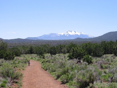 I took this photo of Jack as we neared the parking area. It’s the new desktop picture on my laptop. That’s the San Francisco Peaks in the background; you can see Jack running on the trail, tongue hanging out, on the left.
From here, we headed over to the Snowbowl, where we took the 7-mile road up to the lift. We had lunch at the restaurant there while Jack the Dog rested in the car. We didn’t take the lift because 1) it was open-air, 2) it was windy, and 3) it was 25°F with the wind chill at the top. Instead, we sat and enjoyed lunch on the outdoor patio, watching people climb aboard the lift and watching other people climb off, shedding blankets and rubbing the warmth back into their bodies. We’ll return in the hottest part of the summer, take the lift up, and hike back down. It’s an elevation change of 2,000 feet (9,500 to 11,500) and I’m sure it’ll get my blood flowing.
As for Red Mountain, I’d like to return one day with my good camera and a picnic lunch. It’s the kind of place where a photographer can spend the day, moving from place to place to capture the formations with just the right light.
Discover more from An Eclectic Mind
Subscribe to get the latest posts sent to your email.
