Not something you see every day.
I spent a few weeks in the Sacramento area of California — as I have been since 2013 when I brought my helicopter there for its first frost control contract — in late February and early March. I’ve gotten to know the area pretty well over the past five years and as I continue to explore new places, I also return to the old ones. Lake Berryessa, the largest lake in Napa County, is one of these places.
I first discovered it during a drive up Putah Creek, starting in Winters, CA. From there, I made a stop at the Lake Solano Campground (which I eventually stayed at for the first time this year) and noted its crazy collection of peacocks. Farther up the road, I passed numerous parking areas for fishing and hiking and picnicking. Still farther, the road crossed the creek, wound up a hill, and passed the Monticello Dam, which holds in the waters of Lake Berryessa. Penny and I have hiked in various places along the shore, driven much of the west side’s shoreline, and even flown over it numerous times in my helicopter.

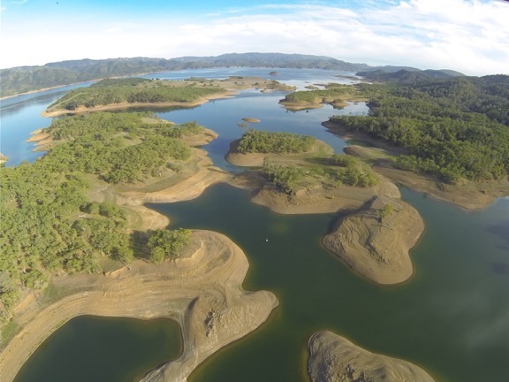
An aerial view of Lake Berryessa, shot with a GoPro on my helicopter back in March 2014. The water was very low.
For the first four years I’ve been in the area, the lake level was low — very low. This isn’t surprising given the serious drought that affected nearly all of California. All of the lakes I flew over were low. But this year things were different. This year, all the lakes are full, nearly full, or even — in some cases — overflowing. Lake Berryessa is one of the lakes with too much water.
Man-made lakes — basically, any lake that holds water in with a dam — usually have flood control features built in that guide excess water safely out of the lake and into a receiving stream or river. This is normally done with the use of a spillway that can be opened or is automatically utilized before the water level reaches the top of the dam.
Spillways come in different styles. The most common is a sort of water chute that excess water flows down, away from the dam. Most dams have this kind of spillway. The Oroville Dam, which has been in the news a lot lately, has spillways like this, one of which was severely damaged by floodwaters.
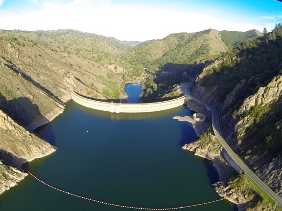
Another less common type is an open bell mouth spillway. That’s the type at Lake Berryessa. It’s a round concrete hole not far from the road and the dam. From Wikipedia:
Near the dam on the southeast side of the reservoir is an open bell-mouth spillway, 72 feet (22 m) in diameter, which is known as the Glory Hole. The pipe has a straight drop of 200 feet (61 m), and the diameter shrinks down to about 28 feet (8.5 m). The spillway has a maximum capacity of 48,000 cfs (1360 cms). The spillway operates when there is excess water in the reservoir; in 2017 after heavy rains it started flowing, for the first time since 2006.

In looking through my archive of photos from 2014, I found a GoPro photo of the dam from the air that clearly shows the Glory Hole when it isn’t in use.
It was in the news in February because the lake had finally filled, after 11 years, and water was flowing into the Glory Hole. Of course, I had to go see it. So when I got the helicopter into California and needed to a “maintenance flight” to check a few things, I headed over there. Sure enough, water was flowing into the hole and a small gathering of people along the road were looking in. I flew by a week later and the water was still flowing in.
I wanted to see it again from the ground, so I returned on Saturday. By that time, Penny and I were on our way home from nearly four months on the road so I had the Turtleback on my truck. Once again, I’m so glad I downgraded from my big fifth wheel; parking in the very crowded parking area was remarkably easy.
There were a lot of people there. It was, after all, Saturday and the Glory Hole had been on the news quite a bit. It made a good, easy, and free point of interest for sightseers.

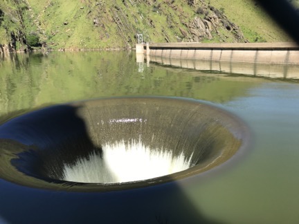
The Glory Hole, photographed from the road. That’s the dam to the right. The water is pretty close to the top.
Penny and I joined the crowd and walked along the road for a good look. The chain link fence made it difficult to get a good photo. The hole is right next to the road and pretty much fills the camera lens. But I did my best.
A guy was out there with a Phantom 4 drone so I decided to give my drone (AKA flying camera) a shot when he was done. I went pack to the truck, put Penny inside, and pulled out my drone. Within about 5 minutes, I had it all set up in a clear area between parked cars and the fence downstream from the dam. When I was sure the other drone had landed, I launched mine.
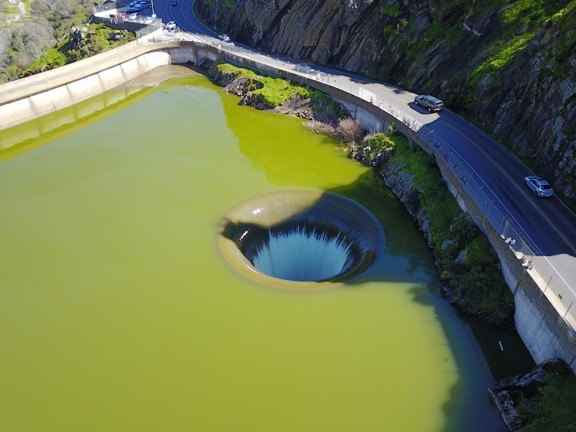
Understand that I’m still learning how to use my Mavic Pro. I’m also very careful. Immediately after launching, I took it up over the lake, away from people. Then I captured some still and video shots of the Glory Hole from the air, including a short pass where I flew directly over the hole with the camera pointing straight down.

I really don’t know why the water looks so green in this shot. I don’t think it’s the camera. It must be something to do with the light.
I had the drone out yesterday at @LakeBerryessa‘s Morning Glory Hole. A shame the water looks so green here. pic.twitter.com/aoQ960ZASI
— Maria Langer �� (@mlanger) March 12, 2017
I tweeted the video clip and got a lot of positive feedback about it. I also got a request to contact the folks at a video licensing company who want to represent me on the resale of the clip to news other media organizations. I’ll all for that, provided my FAA Commercial UAS Pilot certificate has come through; it’s not legal to sell drone photography without it. Need to get home and check my mail to see if the paperwork is there; I applied back in January so I should be good.
I need more practice using my Mavic and I intend to get some on my way home. I had it out again this morning from my campsite at Bodega Bay. I’m hoping to put together a little montage when I get home and share it here on the blog. Stay tuned.
How about doing something to show your appreciation? I’d love it if you’d add a comment at the end of this post to share your feedback with me and others. But I’d really love it if you’d visit my Support page and chip in a few dollars to help cover the cost of hosting this blog and motivate me to keep writing new, interesting content. It’ll only take a moment and I really would appreciate it!
Discover more from An Eclectic Mind
Subscribe to get the latest posts sent to your email.

You’re getting good at slow panning. That is probably the toughest thing to learn.
Thanks! I’m really practicing a lot. That isn’t even one of my better clips. Did some practice real estate shots of the casino I parked at Saturday night. I think they came out great. I need to make a “best of so far” reel.
Also, are you aware that you can set reaction speeds? Try this article. It’s long but there’s some good stuff in it: http://fromwhereidrone.com/dji-go-app-step-step-guide-every-menu-button/
I don’t suppose that you could hover straight down the opening and shoot up. ;) But I love the video that you shot.
I thought of going lower but it really spooked me. Flying over the ocean today spooked me, too. All it takes is for one motor to fail or a bird attack and that thing is going in the water.
It won’t shoot straight up. I think I can get a 30 degree up angle if I tweak one of the dozens of buried settings.
Great images. Good flying with the Mavic.
The green water is probably a ‘blue-green’ algal bloom. With lots of recent rainfall the water should be well oxygenated but blooms are more often seen in the hot months and early fall.
Your photo from 2014 shows the same greenish tinge, but not as extreme.
If you google ‘berryessa, algae’, you will see that this is a persistent problem for the northern half of the lake and when it gets bad the algae form large sticky ‘islands’ of green gloop, thick enough to slow boats.
Thanks for that info. I should have looked it up. Was just eager to get the post out this morning so I could hit the road.
Love the images and the story!!! Amazing to see all this, Maria!!
Thanks, Shirley! I was thrilled to see that I had a shot of the dam with the Glory Hole high and dry. Really helps put the story together.
You’re doing very well with the drone, Maria! Love the Glory Hole – is it man-made or a natural phenomenon?
Thanks, Joe! Definitely man-made. Part of the dam system.
See the drone videos and photos of Lake Berryessa filling and Glory Hole spilling at http://www.LakeBerryessaNews.com. More than 3,000,000 views on YouTube.
This is one shot where a drone makes a lot more sense than a helicopter. Even in a twin engine aircraft, I’d be thinking “sure hope those engines don’t hiccup” the whole time I was over that hole. Quite a drop to the bottom at 200 feet down. I imagine that if anyone went over the edge of that thing they’d never come out intact.
Neat perspective shot, thanks for sharing it!
Thanks and I agree. There are definitely photo jobs that a drone is much better for. Basically anything up close and personal. I flew over the area twice in my helicopter but wouldn’t ever get low enough to get shots like these. Just too close to spectators.
And a woman did fall down the hole back in 1997. As you surmised, she didn’t survive.