And another [safer] flight under the bridge.
Back in November 2014, I blogged about the time I was in a helicopter that flew under the Burro Creek Bridge on Route 93 at Burro Creek. It was probably on my mind back then as I was reviewing log book entries for a book I’m working on about my flying experiences. I just re-read that post and I do recommend it. It’s short — for me, anyway — and tells an interesting story that gives you some insight into the minds of helicopter owners and pilots.
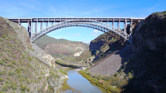
Plenty of room to fly under, no?
Anyway, yesterday I drove north on Route 93, starting my annual migration from my snowbirding stay in Arizona to my late winter/early spring work site in the Sacramento area of California. (Yes, my seven-month “vacation” is nearly over.) I gave myself about 10 days to make the trip and planned stops along the Colorado River near the Hoover Dam, Death Valley, and possibly Lake Tahoe. Or the California Coast. I don’t really know yet. One of the things I like most about my life these days is my unfettered ability to make and change plans on the spur of the moment.
I’d been thinking about the drive for a while, wondering what stops I could make along the way. Burro Creek was a no-brainer. There’s a BLM campground down along the creek about a mile or so off Route 93. I’d considered stopping there for an overnight stay on my way south from Vegas in November but had ultimately chosen a different route that kept me on the Colorado River. The campground isn’t much — in fact, the water is turned off there so the bathrooms are closed up and I’m not even sure if you’re allowed to use the dump station — but it does have ramadas (shade structures) at each campsite, along with picnic tables and a nice desert garden. And plenty of hiking opportunities.
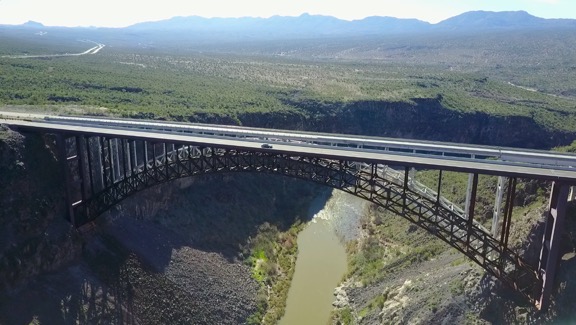
A view back toward the campground, looking southwest. That’s Route 93 south of the bridge in the distance.
Burro Creek Campground is about an hour north of Wickenburg, which is where I’d spent the previous two nights. Perfect timing for a break on my estimated three hour drive to Willow Beach on the Colorado River near Hoover Dam. I pulled in, drove down the cracked asphalt road to the campground, and parked in the day use area so the campground host wouldn’t try to hit me up for camping fees.
The Burro Creek Bridge — or should I say bridges? — is clearly visible from the campground. It’s a pair of two-lane truss arch bridges that are about 680 feet long about 390 feet over the floor of Burro Creek’s canyon. The first bridge was built back in 1966 and carried all northbound and southbound traffic. In 2005, as part of route 93’s widening project, they built a second almost identical span right beside it. The new bridge now handles northbound traffic while the old bridge handles southbound traffic. I’m glad they built a matching bridge. It really helps preserve the aesthetics.
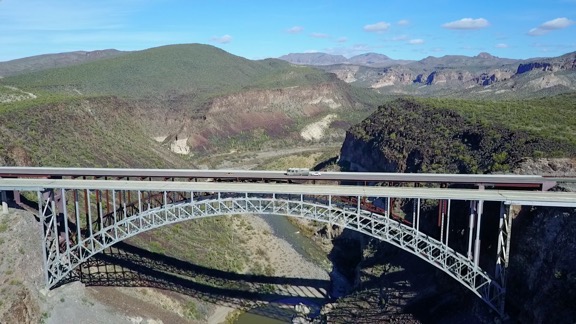
The two bridges are nearly identical, despite being built 40 years apart.
(A side note here: Route 93 between Wickenburg and I-40 near Kingman had the local nickname “Death Highway” because of the number of deadly accidents — often head-on collisions — that occurred there when it was just one lane in each direction. Widening it was long overdue since it handles nearly all auto and truck traffic between Phoenix and Las Vegas. Parts of it are still one lane in each direction. You can learn more about Route 93 in Arizona on Wikipedia.)
I had done a photo shoot of the new bridge back in 2005 with an aerial photography professional. It was a memorable flight, mostly because he did the shoot with a pair of Hassalblad medium format film cameras. These are extremely costly cameras and the reason he had two of them was so that when he finished shooting a roll of film, he could switch to the other camera instead of fumbling at an open aircraft door to reload film. I think each roll only had 12 shots. I distinctly recall hearing the mechanical sound of the shutter and his manual winding of the film though the intercom system since the microphone was so close to the camera. I orbited the bridges several times. I know he was disappointed with our timing; the second span wasn’t quite done but yet it wasn’t open enough to be dramatic. There was just a narrow gap maybe 50 feet wide in the middle of the roadway. We should have arrived about two weeks before for a more dramatic shot or two weeks afterward for a completed span.
I was thinking a lot about that photo shoot as I walked down to the creek with my Mavic Pro flying camera tucked away in my day pack. The construction company — or Arizona Department of Transportation? — had flown the photographer in to Phoenix from somewhere in the midwest for the shoot. He’d rented a car and drove to Wickenburg. I flew him up there with the doors on, then landed in the construction area to pull off his door and stow it in the back seat. We’d done the flight, circling around and and around. It was midday, but there were still shadows because of the angle of the sun in the deep canyon. I’d landed again to put the door back on and then we’d headed back to Wickenburg. The only reason we hadn’t done the whole flight with the door off was because I could get better speed in transit with the door on and it was at least a 30-minute flight. I’m thinking the whole job was about 1.5 hours of billable flight time, but without consulting my logbook, I can’t be sure. Total cost of those photos? Easily a few thousand dollars.
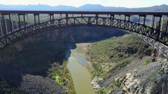
Really. Nearly identical.
I walked as far as I could — at least a half mile — getting almost under the power lines that spanned the canyon just southwest of the bridge. I was hoping to be on the other side of them so I wouldn’t have to worry about them interfering with drone operations, but Burro Creek was running full and fast and I’d gone as far as I could without getting too close to the canyon wall. I spread out my collapsable landing pad in one of the few boulder-free areas, and got to work setting up the Mavic and its controller for flight. I have it down to a science at this point and it only takes me about five minutes from the moment I take it out of the bag to the moment everything is powered up and the Mavic is in GPS mode.
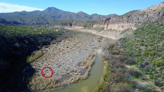
I grabbed this image of the video on the Mavic’s return flight. I circled where I’m standing with the landing pad. You can see the campground behind me.
I couldn’t tell how far above the canyon floor the power lines were. I knew they were lower than the bridge, but I also knew that we’d flown under them. They had to be at least 100 feet up. Still, when I launched the Mavic I kept it just 50 feet up until I knew it was on the other side of the wires. (I now estimate they’re at least 150 feet feet from the canyon floor, but likely more than 200.)
I spent the next half hour or so flying around near the bridge. I flew over it once and under it three times. I didn’t want it to distract drivers on the road, so didn’t fly anywhere where the average driver would see it. I had to bump up the maximum altitude for the flight over the bridge, but I figured that was okay because I was still within 400 feet of either the bridge roadway or canyon walls. Certainly nowhere where a manned aircraft should be flying — although I think I’ve already established that it was where a manned aircraft could be flying.
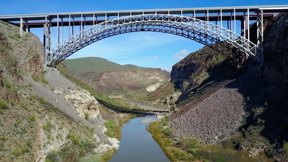
This photo was shot from under the power lines.
I switched batteries after two flights and used up 20% of the second battery before finishing up. Penny had very patiently waited nearby. She doesn’t mind the drone or its bee-like buzzing but stays clear of the landing pad when it’s coming or going.

Want to become a commercial drone pilot? Start by learning all about the FAA’s Part 107. This book will help. Buy the ebook edition on Amazon or from Apple. Or buy the paperback edition on Amazon.
When I was finished, I powered everything down, replaced the Mavic’s gyro lock and cover, and folded it up. Within a few minutes, I was ready for the return hike with everything stowed away in my day pack again.
I got a bunch of video shots, as well as some still shots. This blog post shows off mostly screen grabs from the video. Launching from the stream bed inside the canyon limited what I could do, keeping in mind that I had to keep the Mavic within sight during the flight (per FAA rules).
I think that if I’d launched from up alongside the roadway, level with the bridge, I could have gotten the same shots that Hassalblad photographer had captured twelve years before — for a lot less money. But there really wasn’t a good place to launch from that wouldn’t distract drivers. And it isn’t as if this was a real mission. It was just more practice.
I wonder what that Hassalblad photographer is doing these days. I seriously doubt he’s still using those cameras to take aerial photos.
Discover more from An Eclectic Mind
Subscribe to get the latest posts sent to your email.
