
A Jeep drive to an exploratory hike.
Kirk and I spent much of Wednesday morning clearing boxes of items out of my RV (AKA the “Mobile Mansion”) as part of a major cleanup. It was a big job made more manageable by a helper who kept me focused and moving. I suspect that if Kirk and I joined forces for any big job, we’d get it done in record time.
Afterwards, we went inside for a break and lunch. I whipped up some pizza dough and picked eggplant, zucchini, and tomatoes from my garden. By 1 PM, we were each making our own pizza masterpieces, which we later ate out in the shade on the deck.
That took us to 2 PM. Half the day was still ahead of us.
We’d talked about taking out the boat for a short ride, but it was windy down on the Columbia so we put it off for another day. Then Kirk suggested taking the Jeep up onto Jumpoff Ridge, where a road wound along the edge of the cliff. I’m always game for a Jeep ride, so we pulled out the Jeep, loaded Penny and some bottled water on board, and took off.
On Jumpoff Ridge
Jumpoff Ridge is the name of the cliff face due south of my home. It rises more than 1,000 feet from the shelf where my home sits. The side facing me is layered basalt columns that are strikingly beautiful, especially with golden first or last light shining on them. Topo maps and satellite images show a road up there that meanders along the top of the cliff. One of the local property owners, in an attempt to avoid contributing to road association fees, claimed he’d use that road to access his land — yes, his 20 acres does include the cliff face and a sliver of land on top. I’d been wanting to check out the road for at least a year and was looking forward to the drive up there.
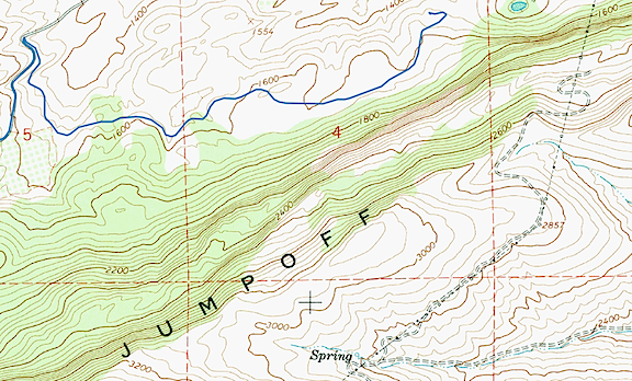
A topo map shows the steep cliff on the north side of Jumpoff Ridge. The road we planned to drive is indicated by the double dashed line atop the cliff. The blue track line to the right of the sharp turn is the road I live on, which was built after USGS topo maps were published.
I knew how to get to the road we sought. Follow Joe Miller Road to Stemilt Loop Road and turn left at the church. Then follow that to Jumpoff Ridge Road. From there, it turns to improved gravel. It’s a moderately steep climb through ponderosa pine with tantalizing glimpses of the orchard-filled land in the Stemilt Hill and Wenatchee Heights areas below. There are about a dozen lots, some of them with homes on them, at the top of the road. One of them belongs to one of my charter clients and I’ve landed and departed with the helicopter from his yard at least a dozen times over the past two or three years.
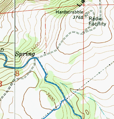
At the top of Jumpoff Ridge, the topo map showed a 4-way intersection. But there was no left turn to the radio facility.
That’s also where the road splits. A left hand turn at my client’s house would take us to the road we sought, but the only left hand turn we saw looked like my client’s driveway. We could see the antennas — marked “Radio Facility” on the topo map — beyond and knew that’s where we needed to be. But there didn’t seem to be a way to drive through. So we went straight, looking for another left hand turn.
We found it a while later, but it was gated and locked. We kept going, passing under the Bonneville power lines and a handful of other homes. (When people say I live “out there,” they should come visit these people. They’re way out there.) Realizing the road was not likely to take us where we wanted to go, we turned back and had a closer look at that gate. It was securely locked with signs warning against trespassing. The road was strictly for communications company and power company use.
I guess my freeloading neighbor had no idea what he was talking about when he claimed he’d use that road to access his property. (Or, more likely, he was just a lying sack of sh*t.)
We stopped to consult the map I’d preloaded onto my phone’s Gaia GPS app. I’d already told Kirk about Clear Lake, where I’d stopped in November with my friend Don. It had been frozen hard that pre-winter day, after an early hard freeze. Don had bowled rocks across its surface just to hear the weird echoing sound as they bounced and slid. I thought it was a good alternative destination. The map showed a road off the southwest-bound powerline road (which was not gated) that would “shortcut” to it. It even had a name: Rock Ridge Road. We headed off to find it.
The road climbed steeply up a rocky slope and joined up with the Bonneville Power lines. It veered off into the forest and rejoined the powerlines. Then there was our right hand turn, right where the map said it would be. But there was also an “Authorized Vehicles Only” sign. Really? Ugh.
Faced with the choice of going back or taking the longer way around, we kept moving forward. The road was a lot longer than I remembered. It joined and left the powerlines several times, mostly climbing. There were tall pines, surprisingly green grass, and large meadows. I could easily imagine elk grazing there.
My 1999 Jeep Wrangler drove like a champ. I’ve owned this vehicle since new and, quite frankly, I don’t take very good care of it. In fact, I think it’s safe to say that I routinely beat the crap out of it. It had been flashing the Check Engine light on rough terrain on and off, coupled with a stuttering engine, for months.. Earlier in July I’d finally had it checked and fixed. Turned out to be a wiring harness damaged by rodents — a much cheaper fix than I’d been prepared for. This was a good practice run for our upcoming camping trip to Glacier National Park and I was glad to see it running so smoothly.
After miles of rough road, we finally found and made the right hand turn that would take us down off the ridge: Schaller Road, according to the map. It was rocky, rough, and full of switchbacks. That dumped us onto Upper Basin Loop Road. We caught a glimpse of a pickup truck turning onto a road up ahead — the first vehicle we’d seen in over an hour — and kept on straight until we reached the turn for Clear Lake.
At Clear Lake
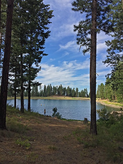
Clear Lake is a small reservoir in the woods.
Clear Lake is a very small reservoir in the Stemilt Basin. It likely collects and stores water for one of the dozens of Stemilt cherry, apple, or pear orchards in the Stemilt Hill area. The road ends at a locked gate close to the lake. We parked and got out for a walk. Penny was very happy to get out of the Jeep, where she’d been riding on Kirk’s lap since our departure from home. There was no one around and it was peaceful.
The topo map showed another larger lake to the west, on the other side of the ridge: Lily Lake. Although our time was somewhat limited — Kirk had a meeting later that evening in Cashmere and the drive had already taken longer than planned — we set off to see if we could catch a glimpse of the other lake. Like me, Kirk has kayaks and we’re always interested in finding new destinations for a leisurely paddle.
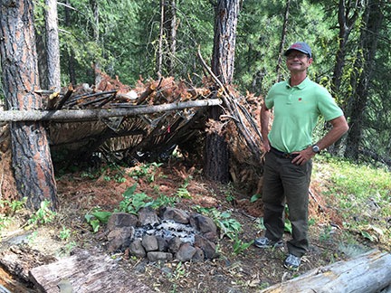
We stumbled upon this old lean-to in the woods up the hill from Clear Lake.
We followed a trail and then a road and then a trail o the west side of the lake and started the climb up the ridge. Near the top, we found an old lean-to made with branches and the remains of a campsite. But not much else.
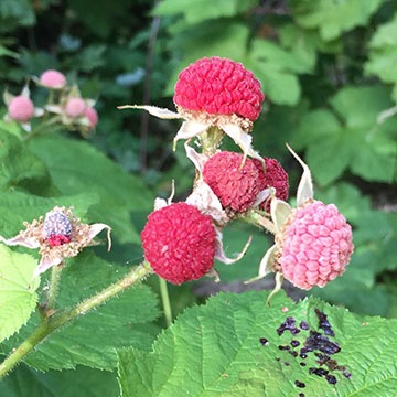
Ripening thimbleberries. While not as tasty as raspberries or blackberries, they do make a nice treat.
We dropped down and followed the road back to the southeast. There was another locked gate and we walked around it. That took us southwest on a road that small trees were already starting to reclaim. Thimbleberry bushes lined the road and Kirk and I picked and ate the reddest ones. A small creek roared in a steep but narrow canyon beside us. After about a quarter mile, the road dead-ended at a dam with a valve: the control for the underground pipeline that was filling Clear Lake from the creek. There was no road or trail beyond to Lily Lake.
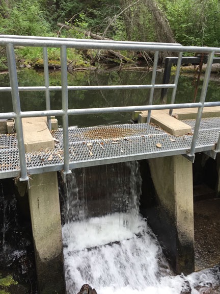
A concrete dam in the forest formed a small pond where a buried pipeline fed Clear Lake. Water over the spillway fed the creek we heard in the ravine beside the road.
After snapping a few photographs, we headed back to where the Jeep waited. We’d visit Lily Lake another day from a road on the other side of the ridge that I’d already spotted on the map. There were other lakes up that way and it would make a good day trip for us, giving me the Jeep outing I wanted with the hiking Kirk preferred. Win-win.
Heading Home
The trip home was uneventful. It was less than a mile back to pavement from Clear Lake. Then back to the church and Joe Miller Road and, eventually, my road.
Kirk snacked on some cold pizza as we loaded up his car. He headed out for his meeting. I heated the rest of the pizza in the oven and snacked on it while unwinding from the bumpy trip, glad to have found an excellent traveling companion for future adventures.
Curious about our route? Click here to see it and all the photos I took.
Discover more from An Eclectic Mind
Subscribe to get the latest posts sent to your email.
Interesting exploration, well-told. That lean-to den you found with Kirk looks like a classic ‘army cadet’ survival build.
Here in the UK there is little ‘mystery land’, everyone knows the person who owns every inch. The deeds will prove it. What we like about both the northwest of the US and the Canada beyond the 49th is this sense of vagueness about where the boundaries are.
My cousin in BC found his neighbour cutting down trees on land he thought he owned. The surveyor was called in. My cousin owned what he thought he did, plus ten more acres of the neighbour’s lot. In the UK that would have resulted in an expensive two-year law suit. But they had a beer, shared a meal and remained friends. So strange to us, where space is so precious.
There is SO MUCH land out here. We can drive for hours on back roads and not run into another soul. And hiking trails — they go on for ever and ever. But when it comes to property lines where people live, we usually know exactly where we stand. I don’t think lawsuits are too common, though.