A photo tour.
Earlier this month, my friend Jim’s cherry drying contract in Chelan, WA ended. He was faced with the task of bringing his helicopter and his truck back home to Coeur d’Alene.
His helicopter was running low on time — it would need a 100-hour/annual inspection within 6.5 hours. It was a 1.5 hour trip to Coeur d’Alene. He planned to fly home, pick up his wife, fly back to Chelan so she could drive the truck home, and then fly back to Coeur d’Alene. In other words, he would put 4.5 hours on it, leaving just 2 hours before maintenance was due. That’s cutting it pretty darn close.
My helicopter was relatively fresh out of maintenance and I was suffering from the RV version of cabin fever, so I volunteered to do a flight of two helicopters from Chelan to Coeur d’Alene and then fly him back to Chelan so he could drive the truck back. We agreed on a meeting time of about 5 PM.
I figured I’d use the flight to experiment with my three GoPro cameras. I wanted to give the wireless remote a good workout on the GoPro Hero 2, which I use as my “nosecam.”
Chelan is about 20 minutes from my base (at the time) in Wenatchee Heights. After rigging up the cameras and doing a preflight, I took off on a route that mostly followed the Columbia River.
I started having trouble with the GoPro remote right from the start. First, I discovered that the remote’s battery was too low to operate. This wasn’t a huge deal because I had a USB power supply and could plug it in. But it did irk me because I thought it was fully charged. What was worse, however, and couldn’t be resolved in flight, was that the remote back on the camera had apparently turned itself off before I used the remote to turn the camera on. The remote couldn’t find the back (and camera) and, thus, couldn’t turn on the camera. It wasn’t until I got to Chelan that I was able to resolve that problem.
The skidcam and cockpit cam worked fine, though.
I had the skidcam set up for one still photo every 5 seconds. In hindsight, I should have set it for every 2 seconds. But I did capture a bunch of nice shots, like this one as I departed my landing zone. The orchard I’m on contract for fills the frame; you can see my shadow:

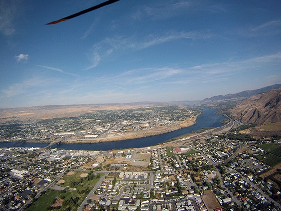
A bit further along on the flight, as I flew out of the Squilchuck Valley, the skidcam caught this image of South Wenatchee, the Columbia River, and East Wenatchee:
I should mention here that the skidcam ran until its battery died; I only shut it off briefly while I waited in Chelan and later in Coeur d’Alene. I have over 3,500 photos from that camera.
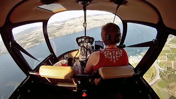
My route followed the Columbia River, flying mostly right over the main channel. The nosecam would have gotten some really rocking footage that probably wouldn’t have been too useable because of the high winds bouncing me around in the sky. But the stills would have looked good. Here’s a view from the cockpit cam shot not far past the Rocky Reach Dam:

If you’ve got a sharp eye, you might notice something in the front passenger seat. That’s Penny the Tiny Dog’s bed. Penny slept for most of the flight — as she usually does in the helicopter. But every once in a while, she’d poke her head up and look around. Here’s another shot as we came over the ridge and began our descent to Lake Chelan:
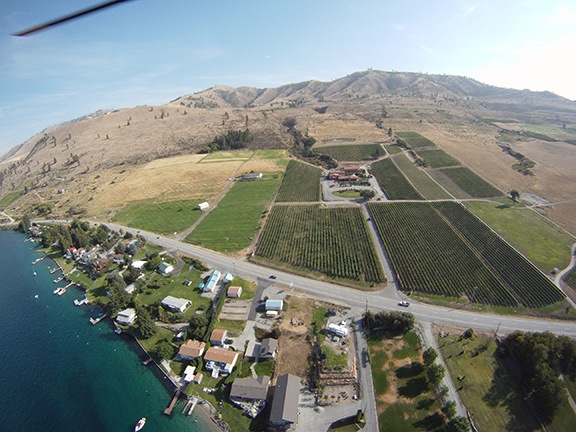
Normally, when I fly to Chelan Airport, I follow the river all the way. But I’d gotten a call from someone who wanted an engagement flight out to Tsillan Cellars Winery on the south shore of Lake Chelan. I wanted to scout the possible landing zones. I circled the winery once and decided that both offered landing zones would work. The one I’d use, however, was the one right at the end of the entry road, by the winery’s big sign. Showy and convenient and not too tight. Here’s a shot from the skidcam as I circled:
From there, I continued on to the airport, flying over downtown Chelan along the way. I landed in the field near Jim’s helicopter and began the shutdown process. While I was waiting for the engine to cool, I put Penny on her leash and dropped her gently onto the ground. She wandered into the frame of the skidcam as Jim pulled up beside me.

Jim topped off both of my fuel tanks with the fuel he had on his truck. There was no reason to drive all that fuel out to Coeur d’Alene later on. I fiddled with my cameras and got them running. We took off as a flight of two with Jim leading the way, heading almost due east.
Despite the fact that the airport is at least 500 feet over the river, we began climbing as soon as we departed. We had to clear the cliffs and climb up to the Waterville Plateau. I followed Jim, trying hard to keep my eyes on the red speck of his helicopter, concerned about catching up with him because of my helicopter’s slightly greater power. (More on that in a moment.) When we topped the cliff, he was easy to spot above the horizon; this nosecam still gives you an idea:

I was pleasantly surprised to find that although we had a tailwind, it wasn’t gusty and the flight was much smoother. The thought of spending an hour each way bouncing around the sky wasn’t appealing. But that wasn’t the case.
I soon learned that my Raven II helicopter is not faster than Jim’s Raven I. There are two possible reasons for this:
- His helicopter is lighter, weighing in at less than 1450 empty. My ship’s empty weight is 1515. I assume he had full fuel (as I did) and we weigh about the same. Not sure how much gear he had on board with him, but I’m certain that his flight weight was lighter than mine. Although probably not much.
- His chart for maximum manifold pressure allows him to pull at least an inch more power than I can in the same conditions. I have no idea why our charts are different.
In either case, he was able to get 5 to 10 knots more airspeed than me. It wasn’t long before his helicopter became a faint dot in the distance.
Meanwhile, the light was getting good and the combines were out harvesting the dry-farmed wheat up on the plateau. We paused enroute while I circled a field with two combines at work. This is where I really wish I’d set the camera for a shot every 2 seconds instead of 5. Although I got one so-so shot, I missed so many other possible shots:

Afterward, I was ahead of Jim for a short time. My skidcam and then my nosecam caught him passing me:


The landscape continued with rolling wheat fields, most of which were already harvested. It suddenly gave way to Banks Lake, a dammed coulee filled with water pumped up from the Columbia River at the Grand Coulee Dam. Here’s the last still clip from the nosecam — I’d mistakenly inserted a 2GB SD card instead of the usual 16GB SD card so I only got about 30 minutes of video. (Sheesh.) Jim told me, over the radio, that the rock formation in the lake is called Steamboat.

Although my skidcam kept shooting, it had shifted somewhat and was no longer level — if indeed it ever was. It produced this slanted view of the lake as we were crossing the cliffs on the other side:

Beyond that, my skidcam caught a few more images of combines out in the field. Here’s one corrected for the camera’s tilt:

After more relatively flat farmland, the landscape began to change. There were more and more trees and canyons mixed in with the farmland.

Soon we were flying along a bend in the Columbia River. Later, we were alongside the Spokane River.

By this time, Jim was so far ahead of me that I simply couldn’t see him. We finally determined, based on distance to KCOE, that he was four miles ahead of me. It wasn’t exactly a “flight of two helicopters” anymore.
A while later, we landed at Coeur d’Alene. Jim’s wife met us there. They exchanged hugs and he put his helicopter away in the hangar while Penny and I stretched our legs. Then he and I climbed back into my helicopter with Penny in the back seat and we took off on the flight home.
By this time, only the skidcam was still taking pictures. And because it was facing mostly into the sun, it didn’t get too many good shots. It’s a real shame because the light was really nice by then. Here’s a sample image shot somewhere over Washington at about 7:47 PM:

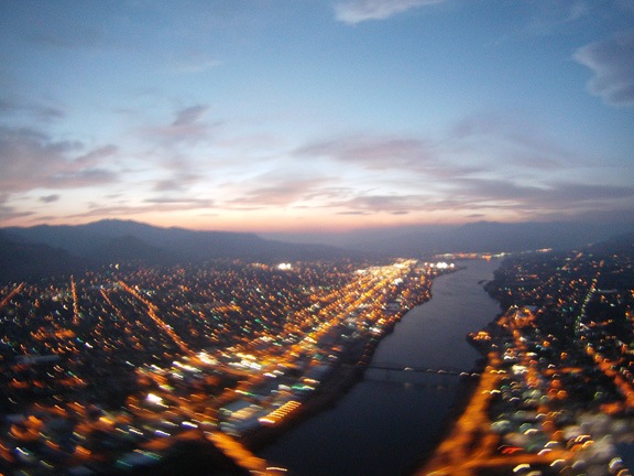
We chatted all the way back. When Iet him off at Chelan Airport, I had to shut down to take on more fuel. Then I took off back toward Wenatchee, where I was living at the time, and he drove off back toward Idaho.
My skidcam caught this image of Wenatchee as I crossed the Columbia River:
I touched down in my parking spot with just my landing light to guide me.
Discover more from An Eclectic Mind
Subscribe to get the latest posts sent to your email.