
I find that there’s more to flying helicopters than giving tours.
Lately, I’ve been getting calls from folks who want to use my helicopter for more than just transportation or tourism.
The first good assignment I got came a few months ago, when I flew a camera crew around the a carmaker’s test track in Arizona. I wrote about it in another blog entry. This past week, I did two more.
The first, on Tuesday, was for a professional photographer hired to take aerial and ground photographs of the new bridge being built over Burro Creek on state route 93. There’s already a beautiful bridge there and the construction crew is building a twin on the north side of it (the road runs pretty much east-west there). Burro Creek runs in a deep canyon there and the Sonoran desert landscape is breathtaking. The site is also far from civilization — about 55 miles north of Wickenburg and perhaps 20 miles south of Wickiup.
It was a cold morning when we left Wickenburg, so I left the helicopter’s doors on. It took us about 30 minutes at my top cruise speed (110-115 knots with two on board and full fuel) to reach the site. I set down in a fenced-in area where the construction folks were storing cactus to be replanted after work was done. I took the passenger door off while my client got his camera equipment out — a pair of Hasselblad medium format cameras with three different lenses. A construction truck pulled up and my client got out to talk to the driver. He came back and told me that the next time I landed, I could land on the new road right near the bridge. It was closed to traffic and was smoothly paved. We took off and began circling the bridges from various altitudes. My client snapped away, cranking the camera’s advance do-dad after each shot. He was perfectly at ease leaning out the door; he’d flown in many helicopters before. After about ten of fifteen minutes of that, I set down on the road near the bridge and shut down. (I had to set down on the edge of the road, as shown in the photo below, because the road was banked for a curve and the only real level spot I could find was at the very edge of the road.) My client climbed out, filled a smaller camera bag with equipment, and walked off to take his ground shots.
I pulled out my iPod and a book and settled down on the side of the road to read. Cars and trucks drove by and I wondered how many of them were headed to or from Wickenburg.
He was gone about 90 minutes. When he returned and finished fiddling around with his equipment, we climbed back on board and I fired the helicopter back up. The light had changed, so we did another 10 or 15 minutes of circles around the bridge at all different altitudes. Then he told me to head back and I broke off circling and headed back.He took some more photos on the way back — using up extra film on shots he thought he might be able to sell the construction folks. Then we set down on Eric Barnes’s dirt strip, on route 93 near the Santa Maria River, so I could put the door back on. With the door off, it was loud and my speed was limited to 100 knots. With it on, it was quieter and I could get it up to 120 knots. When we got back to Wickenburg, I’d put 1.4 hours on the Hobbs. My client paid for that, as well as for some waiting time.
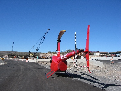
Two days later, I was in Aguila, doing a job for the maker of a “breadcrumb” communications system. Breadcrumb systems, as they were explained to me, create a wireless network that can be used for voice, data, or video communications. The folks who hired me had an impressive system they wanted to mount in the helicopter. The idea was to have me fly around with the system and a few techs on board to see how well the system stayed connected to other breadcrumbs on the ground and how well video that one of my passengers shot could be seen at ground-based stations.
As the photo here shows, I had to remove both doors on the pilot side so they could mount the unit’s antenna. The breadcrumb box itself was positioned at the feet of the passenger behind me; you can barely see it in this photo because it’s just a flat box standing on one end. Although the unit can be powered by batteries, my helicopter has a 28 volt DC port that looks like a cigarette lighter port. The breadcrumb had a cable that could take this voltage, filter it, and step it down to the 12 volts it needed. So they just plugged it into my DC port. The boss of the operation wasn’t happy about the positioning of the antenna — he wanted to dangle it somehow under the helicopter’s body — but we soon proved that it was fine.

One of the techs also had a GPS and, at first, they wanted to mount it on my tailcone. They claimed that in the work they’d done with RC helicopters, they’d found that there was too much interference from the main rotor disk for the GPS to get a good signal. When I told them that my handheld GPS worked in the cockpit cabin, they decided (to my relief) to give it a try. (For the record, I would not have let them mount it on my tailcone. That’s much too close to the tail rotor! We might have mounted it on a skid if we had to.)
My passengers climbed aboard and we took off, flying circles around their base of operations at Robson’s Mining World. One guy in the back did the video while the guy beside him kept reporting on the status of the breadcrumb: green, blinking green, green, green, etc. We kept in touch with other breadcrumbs on the system at all altitudes and even when we flew behind a mountain. We only lost touch once, and that was for only a few seconds. The video went down to the guys on the ground, who clustered around a laptop set up on the hood of a car in the parking area. We did this for about 20 minutes, then landed.
I didn’t realize it then, but I was done with my assignment. What followed was about an hour spent giving everyone there a ride. I took them three at a time and did a 4-minute ride around the base, climbing up the mountain behind Robson’s and descending back into the desert for landing in my designated landing zone. When everyone had their ride, they told me to shut down and have lunch with them. Some other folks would be taking photos of the setup while I was eating.
I ate outside, with the guys from Rotomotion. They build RC helicopter systems to be used for surveillance and unmanned observation. The company founder started the company when he got frustrated that he couldn’t fly an RC helicopter. (Having owned one for a while, I know exactly how he feels; I couldn’t fly mine, either.) He wrote a computer program that would fly the helicopter for him. His company now builds helicopters that work with his Linux-based software system. They had three helicopters with them: a small electric model (on the table in this photo), a medium diesel model, and a large model powered by a chain saw engine.

The software is extremely cool. Once the helicopter is airborne, the software takes over and can hold it in an absolutely perfect out of ground effect hover. You can also tell it to go to certain coordinates at a certain altitude and it’ll go. It uses wireless communications to control an onboard camera or other equipment. If it loses its radio control signal, it’s programmed to return to its home base. Although they have a routine for software-controlled take off, they need a reliable but small altimeter to judge distance from the ground before a good landing program can be written. I have no doubt that they’ll add this feature soon. These guys definitely know what they’re doing.
While the rest of the group went off to go shooting out in the desert, a small group of us remained to watch the RC helicopters fly. A police officer from Chandler had come up to get a demonstration and we just watched. He said that the system has many applications in law enforcement and he seemed excited about it.
I went home a while later and put my dusty helicopter away. I’d logged 1.6 hours for the assignment — not much, but enough to make it worthwhile. And the technology I’d seen while I was out there was well worth the time spent.
Discover more from An Eclectic Mind
Subscribe to get the latest posts sent to your email.